
SEISMOLOGY AND GEOLOGY ›› 2022, Vol. 44 ›› Issue (6): 1484-1502.DOI: 10.3969/j.issn.0253-4967.2022.06.008
• Research paper • Previous Articles Next Articles
RESEARCH ON SEMI-AUTOMATIC EXTRACTION METHOD OF SEISMIC SURFACE RUPTURES BASED ON HIGH-RESOLUTION UAV IMAGE: TAKING THE 2021 MS7.4 MADUO EARTHQUAKE IN QINGHAI PROVINCE AS AN EXAMPLE
LI Dong-chen1)( ), REN Jun-jie1,2,3),*(), ZHANG Zhi-wen1), LIU Liang4,5)
- 1)National Institute of Natural Hazards, Ministry of Emergency Management of China, Beijing 100085, China
2)Key Laboratory of Compound and Chained Natural Hazards Dynamics, Ministry of Emergency Management of China, Beijing 100085, China
3)Key Laboratory of Crustal Dynamics, China Earthquake Administration(CEA), Beijing 100085, China
4)National Disaster Reduction Center of China, MEM, Beijing 100124, China
5)Satellite Application Center for Disaster Reduction, MEM, Beijing 100124, China;
-
Received:2021-12-24Revised:2022-04-27Online:2022-12-20Published:2023-01-21 -
Contact:REN Jun-jie
基于高分辨率无人机影像的地震地表破裂半自动提取方法--以2021年MS7.4青海玛多地震为例
李东臣1)(), 任俊杰1,2,3),*(), 张志文1), 刘亮4,5)
- 1)应急管理部国家自然灾害防治研究院, 北京 100085
2)复合链生自然灾害动力学应急管理部重点实验室, 北京 100085
3)中国地震局地壳动力学重点实验室, 北京 100085
4)应急管理部国家减灾中心, 北京 100124
5)应急管理部卫星减灾应用中心, 北京 100124
-
通讯作者:任俊杰 -
作者简介:李东臣, 男, 1998年生, 现为应急管理部国家自然灾害防治研究院地球物理学专业在读硕士研究生, 主要从事机器学习、 计算机视觉与构造地貌研究, E-mail: lidongchen20@mails.ucas.ac.cn。 -
基金资助:国家自然科学基金(41941016);国家自然科学基金(U2139201);国家自然科学基金(41572193);应急管理部国家自然灾害防治研究院基本科研业务专项(ZDJ2017-24)
CLC Number:
Cite this article
LI Dong-chen, REN Jun-jie, ZHANG Zhi-wen, LIU Liang. RESEARCH ON SEMI-AUTOMATIC EXTRACTION METHOD OF SEISMIC SURFACE RUPTURES BASED ON HIGH-RESOLUTION UAV IMAGE: TAKING THE 2021 MS7.4 MADUO EARTHQUAKE IN QINGHAI PROVINCE AS AN EXAMPLE[J]. SEISMOLOGY AND GEOLOGY, 2022, 44(6): 1484-1502.
李东臣, 任俊杰, 张志文, 刘亮. 基于高分辨率无人机影像的地震地表破裂半自动提取方法--以2021年MS7.4青海玛多地震为例[J]. 地震地质, 2022, 44(6): 1484-1502.
share this article
Add to citation manager EndNote|Ris|BibTeX
URL: https://www.dzdz.ac.cn/EN/10.3969/j.issn.0253-4967.2022.06.008
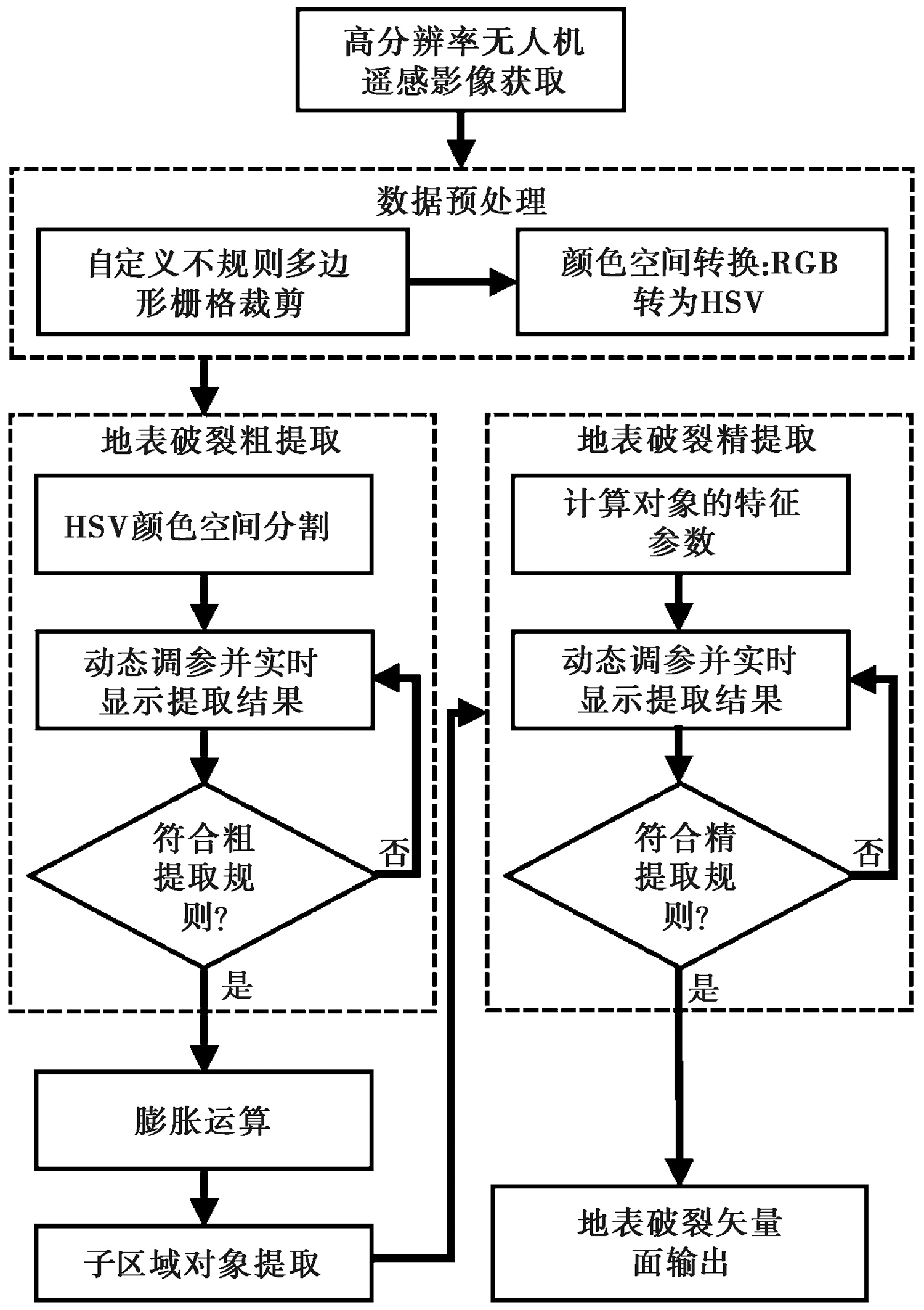
Fig. 1 Object-oriented “rough segmentation-fine extraction” method.
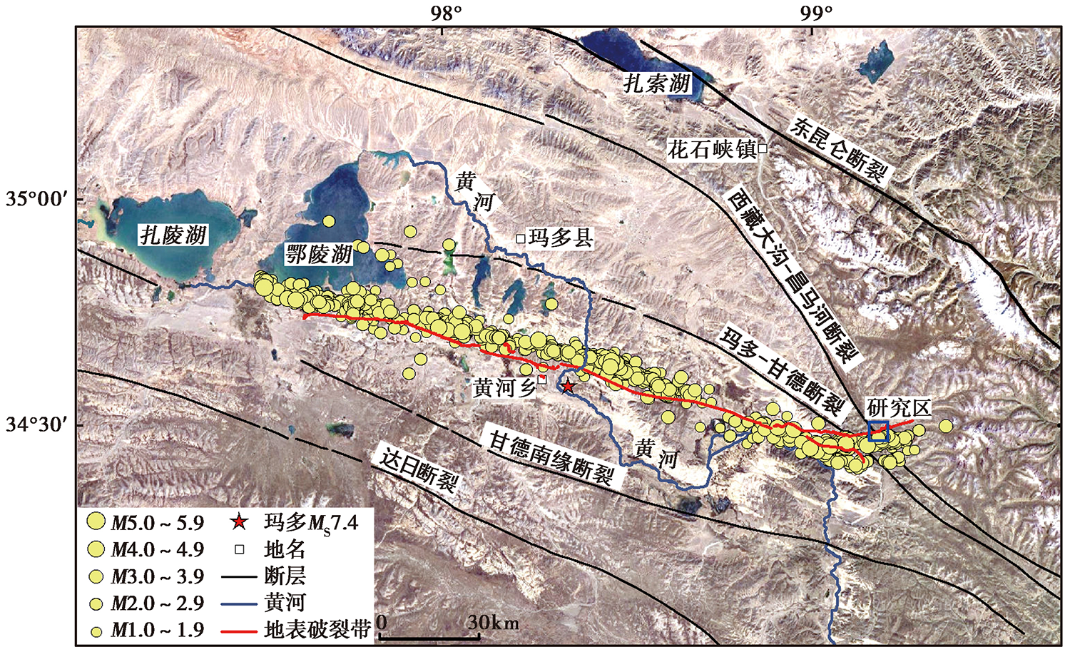
Fig. 2 Aftershock distribution and coseismic rupture zone of the 2021 MS7.4 Maduo earthquake, Qinghai.
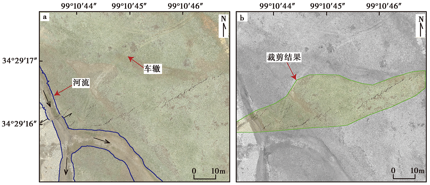
Fig. 3 Raster clipping result of custom irregular polygon.
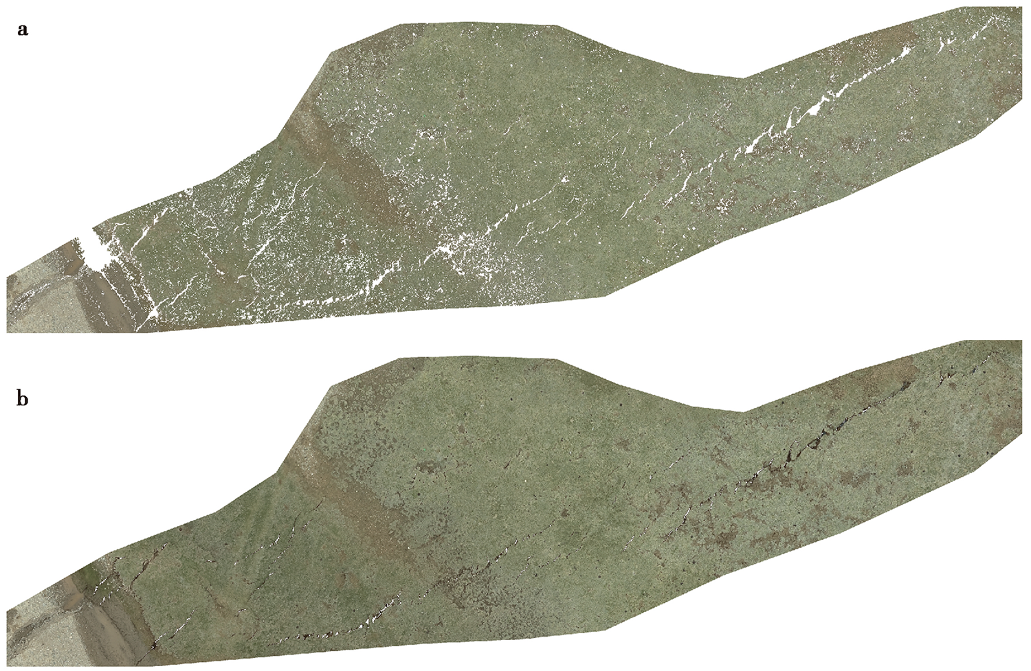
Fig. 4 The results of HSV color space color segmentation.
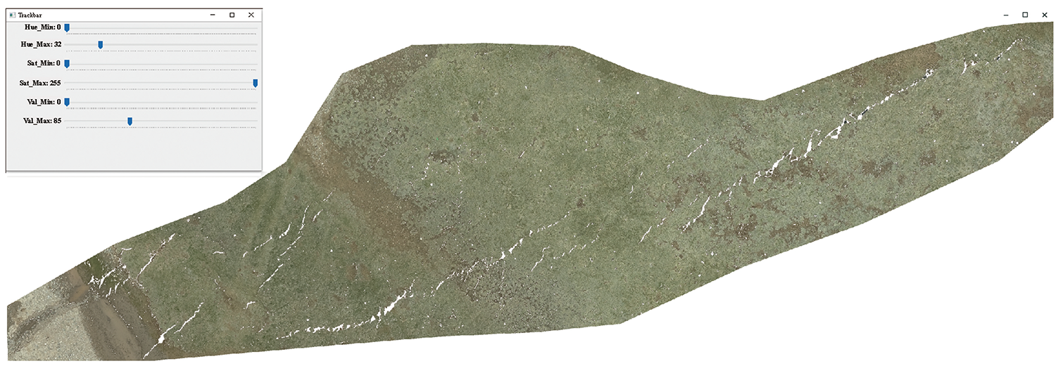
Fig. 5 The dynamic adjustment interface of coarse extraction.
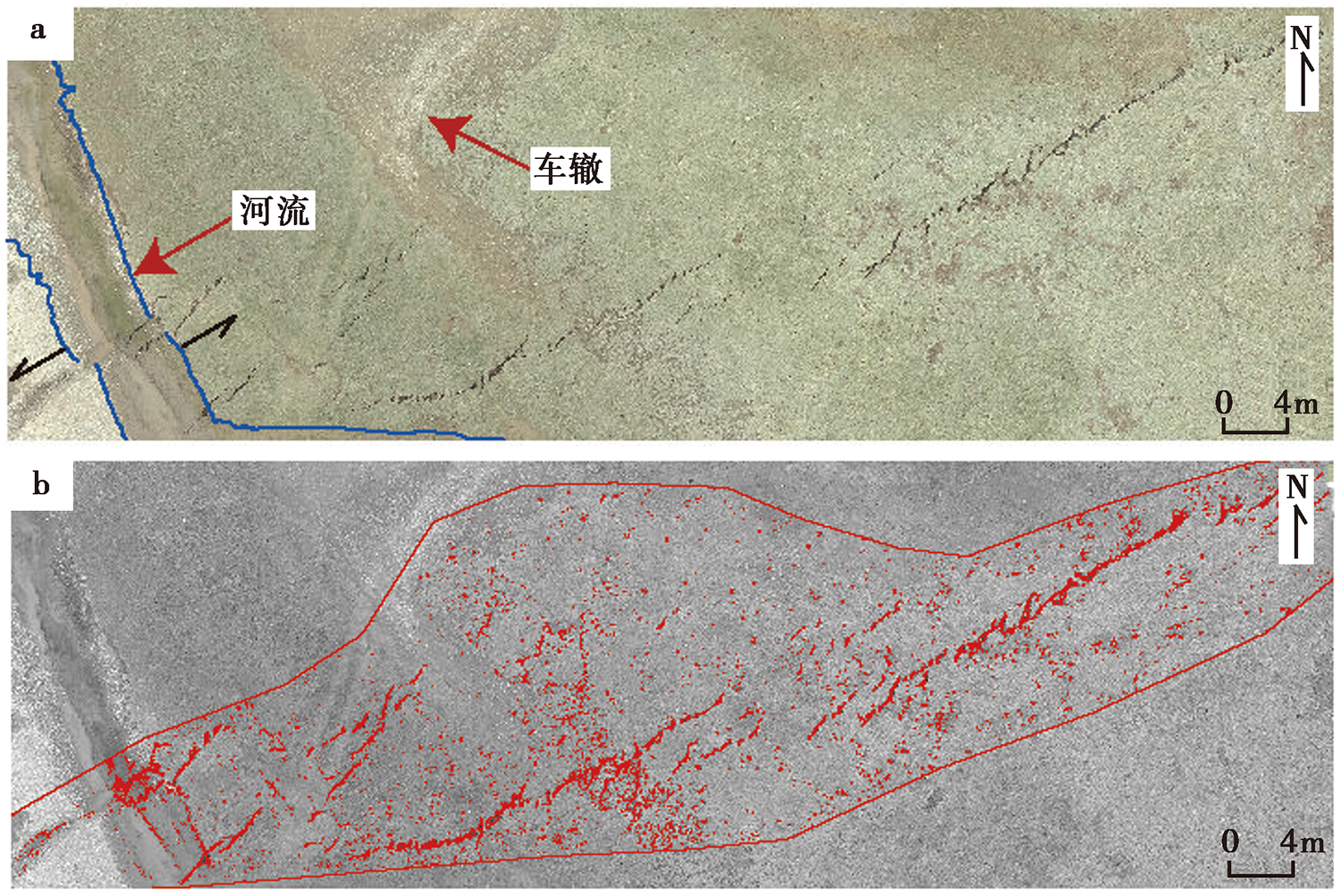
Fig. 6 The ROI area of coseismic surface ruptures.
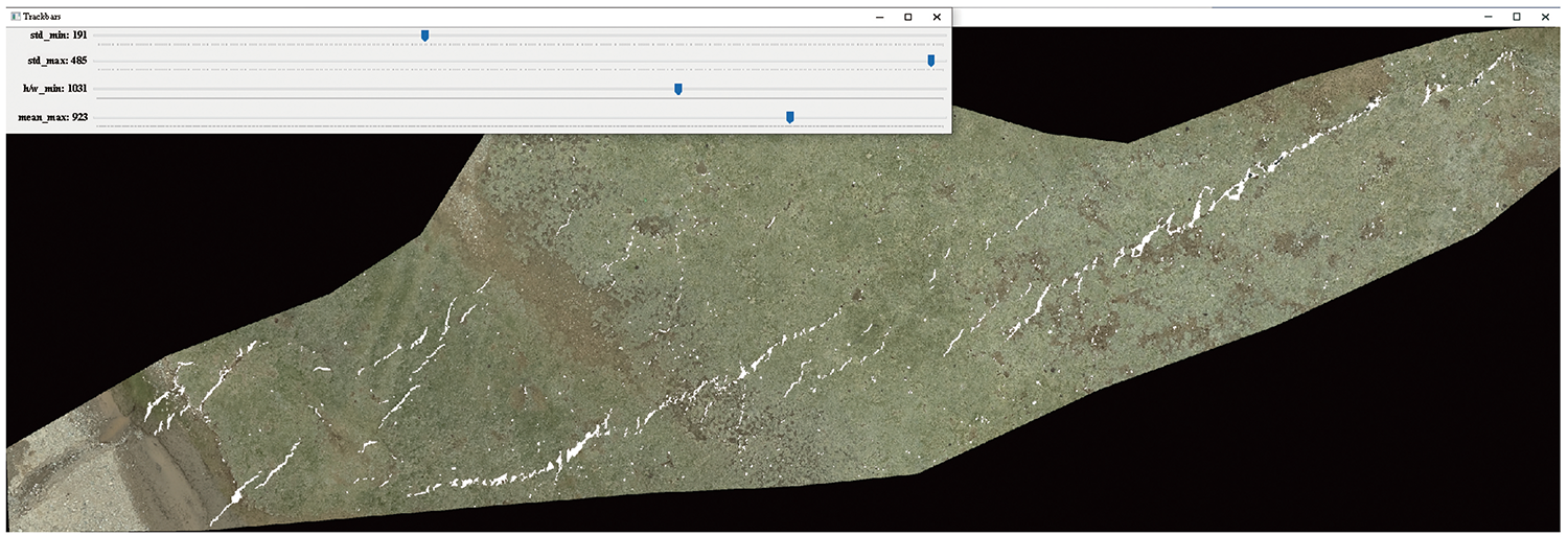
Fig. 7 The dynamic adjustment interface of fine extraction.
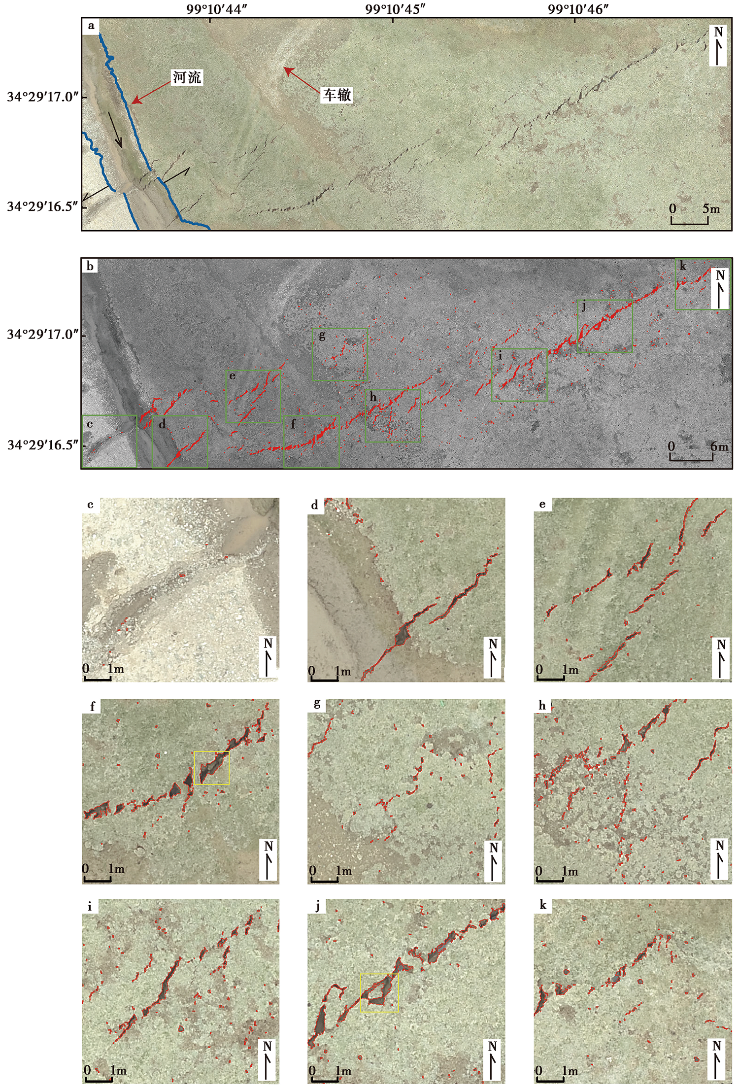
Fig. 8 Extraction results of surface rupture.

Fig. 9 Extraction results of image segmentation.

Fig. 10 Extraction results after demand changes.
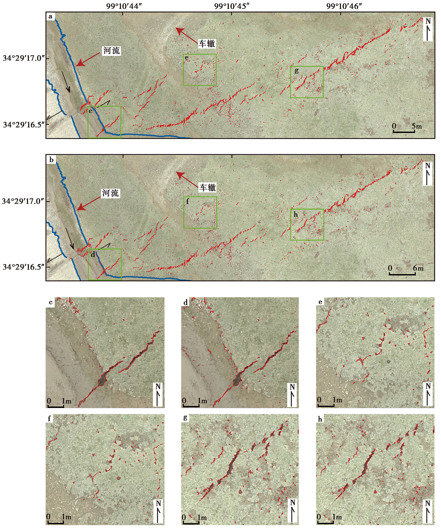
Fig. 11 Extraction results with or without expansion operation.
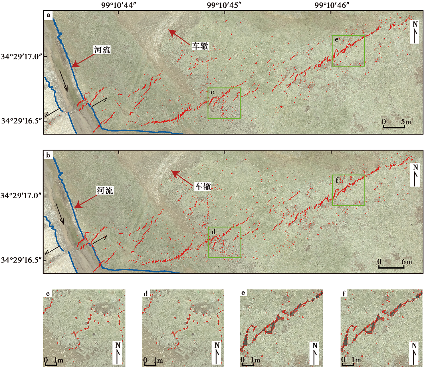
Fig. 12 Extraction results with different characteristic parameters.
| [1] | 陈立春, 王虎, 冉勇康, 等. 2010. 玉树 MS7.1 地震地表破裂与历史大地震[J]. 科学通报, 55(13): 1200-1205. |
| CHEN Li-chun, WANG Hu, RAN Yong-kang, et al. 2010. The MS7.1 Yushu earthquake surface ruptures and historical earthquakes[J]. Chinese Science Bulletin, 55(13): 1200-1205. (in Chinese) | |
| [2] | 邓起东. 2007. 中国活动构造图[CM]. 北京: 地震出版社. |
| DENG Qi-dong. 2007. Map of Active Tectonics in China [CM]. Seismological Press, Beijing. (in Chinese) | |
| [3] | 邓起东, 闻学泽. 2008. 活动构造研究: 历史、 进展与建议[J]. 地震地质, 30(1): 1-30. |
| DENG Qi-dong, WEN Xue-ze. 2008. A review on the research of active tectonics: History, progress and suggestions[J]. Seismology and Geology, 30(1): 1-30. (in Chinese) | |
| [4] |
郭庆华, 胡天宇, 刘瑾, 等. 2021. 轻小型无人机遥感及其行业应用进展[J]. 地理科学进展, 40(9): 1550-1569.
DOI |
|
GUO Qing-hua, HU Tian-yu, LIU Jin, et al. 2021. Advances in light weight unmanned aerial vehicle remote sensing and major industrial applications[J]. Progress in Geography, 40(9): 1550-1569. (in Chinese)
DOI |
|
| [5] | 胡焯源, 曹玉东, 李羊. 2017. 基于HSV颜色空间的车身颜色识别算法[J]. 辽宁工业大学学报(自然科学版), 37(1): 10-12. |
| HU Zhuo-yuan, CAO Yu-dong, LI Yang. 2017. Car color recognition algorithm based on HSV color space[J]. Journal of Liaoning University of Technology(Natural Science Edition), 37(1): 10-12. (in Chinese) | |
| [6] | 黄雪青. 2008. 基于高分辨率遥感影像的信息提取[D]. 重庆: 重庆大学. |
| HUANG Xue-qing. 2008. Information extraction based on high-resolution remote sensing images[D]. Chongqing University, Chongqing. (in Chinese) | |
| [7] | 鞠明明. 2013. 基于面向对象图像分析的围填海工程遥感信息提取技术研究[D]. 南京: 南京师范大学. |
| JU Ming-ming. 2013. Remote-sensing-based information extraction of reclamation project using object-oriented image analysis technique[D]. Nanjing Normal University, Nanjing. (in Chinese) | |
| [8] | 李海兵, 孙知明, 潘家伟, 等. 2014. 2014年于田 MS7.3 地震野外调查: 特殊的地表破裂带[J]. 地球学报, 35(3): 391-394. |
| LI Hai-bing, SUN Zhi-ming, PAN Jia-wei, et al. 2014. Field study of the 12 February 2014 Yutian MS7.3 earthquake: A special surface rupture zone[J]. Acta Geoscientica Sinica, 35(3): 391-394. (in Chinese) | |
| [9] | 李政国. 2008. 基于区域生长法的高空间分辨率遥感图像分割与实现[D]. 南宁: 广西大学. |
| LI Zheng-guo. 2008. The segmentation and realization of high spatial resolution remote sensing image based on region growing algorithm[D]. Guangxi University, Nanning. (in Chinese) | |
| [10] |
李智敏, 李文巧, 李涛, 等. 2021. 2021年5月22日青海玛多 MS7.4 地震的发震构造和地表破裂初步调查[J]. 地震地质, 43(3): 722-737. doi: 10.3969/j.issn.0253-4967.2021.03.016.
DOI |
| LI Zhi-min, LI Wen-qiao, LI Tao, et al. 2021. Seismogenic fault and coseismic surface deformation of the Maduo MS7.4 earthquake in Qinghai, China: A quick report[J]. Seismology and Geology, 43(3): 722-737. (in Chinese) | |
| [11] | 刘超, 雷启云, 余思汗, 等. 2021. 基于无人机摄影测量技术的地震地表破裂带定量参数提取: 以1709年中卫南M7½地震为例[J]. 地震学报, 43(1): 113-123. |
| LIU Chao, LEI Qi-yun, YU Si-han, et al. 2021. Using UAV photogrammetry technology to extract the quantitative parameters of earthquake surface rupture zone: A case study of the southern Zhongwei M7½ earthquake in 1709[J]. Acta Seismologica Sinica, 43(1): 113-123. (in Chinese) | |
| [12] | 陆可, 郑伯桢, 卢春盛, 等. 2021. 基于数学形态学改进的无人机影像配准算法[J]. 合肥工业大学学报(自然科学版), 44(10): 1406-1412, 1419. |
| LU Ke, ZHENG Bo-zhen, LU Chun-sheng, et al. 2021. Improved UAV image registration algorithm based on mathematical morphology[J]. Journal of Hefei University of Technology(Natural Science), 44(10): 1406-1412, 1419. (in Chinese) | |
| [13] | 罗朝阳, 张鹏超, 姚晋晋, 等. 2020. 一种基于形态学的边缘检测算法[J]. 计算机应用与软件技术, 37(2): 177-181, 247. |
| LUO Zhao-yang, ZHANG Peng-chao, YAO Jin-jin, et al. 2020. An edge detection algorithm based on morphology[J]. Computer Applications and Software, 37(2): 177-181, 247. (in Chinese) | |
| [14] | 潘家伟, 白明坤, 李超, 等. 2021. 2021年5月22日青海玛多 MS7.4 地震地表破裂带及发震构造[J]. 地质学报, 95(6): 1655-1670. |
| PAN Jia-wei, BAI Ming-kun, LI Chao, et al. 2021. Coseismic surface rupture and seismogenic structure of the 2021-05-22 Maduo(Qinghai) MS7.4 earthquake[J]. Acta Geologica Sinica, 95(6): 1655-1670. (in Chinese) | |
| [15] | 铁瑞, 王俊, 贾连军, 等. 2016. 强震地震数据统计及其地表破裂特性研究[J]. 世界地震工程, 32(1): 112-116. |
| TIE Rui, WANG Jun, JIA Lian-jun, et al. 2016. Data statistics of strong-moderate earthquake and characteristics research of ground rupture[J]. World Earthquake Engineering, 32(1): 112-116. (in Chinese) | |
| [16] | 王博, 王霞, 陈飞, 等. 2017. 航拍图像的路面裂缝识别[J]. 光学学报, 37(8): 126-132. |
| WANG Bo, WANG Xia, CHEN Fei, et al. 2017. Pavement crack recognition based on aerial image[J]. Acta Optica Sinica, 37(8): 126-132. (in Chinese) | |
| [17] | 王琪. 2011. 关于运动目标特征提取以及车辆颜色识别算法的研究[D]. 成都: 电子科技大学. |
| WANG Qi. 2011. Research on moving target feature extraction and vehicle color recognition algorithm[D]. University of Electronic Science and Technology of China, Chengdu. (in Chinese) | |
| [18] | 徐锡伟, 陈桂华. 2018. 活动断层避让问题探讨与建议[J]. 城市与减灾, (1): 8-13. |
| XU Xi-wei, CHEN Gui-hua. 2018. Discussion and suggestion on active fault avoidance[J]. City and Disaster Reduction, (1): 8-13. (in Chinese) | |
| [19] | 徐锡伟, 闻学泽, 叶建青, 等. 2008. 汶川 MS8.0地震地表破裂带及其发震构造[J]. 地震地质, 30(3): 597-629. |
| XU Xi-wei, WEN Xue-ze, YE Jian-qing, et al. 2008. The MS8.0 Wenchuan earthquake surface ruptures and its seismogenic structure[J]. Seismology and Geology, 30(3): 597-629. (in Chinese) | |
| [20] | 徐岳仁, 陈立泽, 申旭辉, 等. 2015. 基于GF-1卫星影像解译2014年新疆于田 MS7.3 地震同震地表破裂带[J]. 地震, 35(2): 61-71. |
| XU Yue-ren, CHEN Li-ze, SHEN Xu-hui, et al. 2015. Interpretating coseismic surface rupture zone of the 2014 Yutian MS7.3 earthquake using GF-1 satellite images[J]. Earthquake, 35(2): 61-71. (in Chinese) | |
| [21] | 徐志国, 梁姗姗, 张广伟, 等. 2021. 2021年5月22日青海玛多 MS7.4 地震发震构造分析[J]. 地球物理学报, 64(8): 2657-2670. |
| XU Zhi-guo, LIANG Shan-shan, ZHANG Guang-wei, et al. 2021. Analysis of seismogenic structure of Madoi, Qinghai MS7.4 earthquake on May 22, 2021[J]. Chinese Journal of Geophysics, 64(8): 2657-2670. (in Chinese) | |
| [22] | 杨莹辉, 陈强, 徐倩, 等. 2017. 汶川地震SAR形变场电离层影响校正与断层地表破裂线自动提取[J]. 地球物理学报, 60(8): 2948-2958. |
| YANG Ying-hui, CHEN Qiang, XU Qian, et al. 2017. SAR ionosphere signal correction for deformation field of Wenchuan earthquake and extraction of fault surface rupture trace[J]. Chinese Journal of Geophysics, 60(8): 2948-2958. (in Chinese) | |
| [23] | 袁兆德, 刘静, 李雪, 等. 2021. 2014年新疆于田 MS7.3 地震地表破裂带精细填图及其破裂特征[J]. 中国科学(D辑), 51(2): 276-298. |
| YUAN Zhao-de, LIU Jing, LI Xue, et al. 2021. Detailed mapping of the surface rupture of the 12 February 2014 Yutian MS7.3 earthquake, Altyn Tagh Fault, Xinjiang, China[J]. Science in China(Ser D), 51(2): 276-298. (in Chinese) | |
| [24] | 曾举, 李向新, 王涛. 2011. 基于Ecognition的高分辨率遥感影像水体提取研究[J]. 江西科学, 29(2): 263-266. |
| ZENG Ju, LI Xiang-xin, WANG Tao. 2011. Study on object-oriented extracting water from high resolution remote sensing image[J]. Jiangxi Science, 29(2): 263-266. (in Chinese) | |
| [25] | 张波, 何文贵, 方良好, 等. 2015. 1936年甘肃康乐6¾级地震地表破裂带调查[J]. 地震研究, 38(2): 262-271, 333. |
| ZHANG Bo, HE Wen-gui, FANG Liang-hao, et al. 2015. Surveys on surface rupture phenomena of Gansu Kangle M6¾ earthquake in 1936[J]. Journal of Seismological Research, 38(2): 262-271, 333. (in Chinese) | |
| [26] | 张志文, 任俊杰, 章小龙. 2021. 高精度无人机航测在2021年玛多 MS7.4 地震地表破裂精细研究中的应用[J]. 震灾防御技术, 16(3): 1-11. |
| ZHANG Zhi-wen, REN Jun-jie, ZHANG Xiao-long. 2021. Application of high-precision UAV aerial survey in the detailed study of surface rupture of Maduo MS7.4 earthquake in 2021[J]. Technology for Earthquake Disaster Prevention, 16(3): 1-11. (in Chinese) | |
| [27] | 赵慧, 汪云甲. 2012. 融合多尺度分割与CART算法的矸石山提取[J]. 计算机工程与应用, 48(22): 222-225, 248. |
| ZHAO Hui, WANG Yun-jia. 2012. Fusing muti-scale segmentation into CART algorithm on coal gangue extraction[J]. Computer Engineering and Applications, 48(22): 222-225, 248. (in Chinese) | |
| [28] |
Brooks B A, Minson S E, Glennie C L, et al. 2017. Buried shallow fault slip from the South Napa earthquake revealed by near-field geodesy[J]. Science Advances, 3(7): e1700525.
DOI URL |
| [29] |
Klinger Y, Xu X, Tapponnier P, et al. 2005. High-resolution satellite imagery mapping of the surface rupture and slip distribution of the MW-7.8, 14 November 2001 Kokoxili earthquake, Kunlun Fault, Northern Tibet, China[J]. Bulletin of the Seismological Society of America, 95(5): 1970-1987.
DOI URL |
| [30] |
Ren J, Zhang Z, Gai H, et al. 2021. Typical Riedel shear structures of the coseismic surface rupture zone produced by the 2021 MW7.3 Maduo earthquake, Qinghai, China, and the implications for seismic hazards in the block interior[J]. Natural Hazards Research, 1(4): 145-152.
DOI URL |
| [31] |
Ren Z, Zhang Z. 2019. Structural analysis of the 1997 MW7.5 Manyi earthquake and the kinematics of the Manyi Fault, central Tibetan plateau[J]. Journal of Asian Earth Sciences, 179: 149-164.
DOI URL |
| [32] |
Rodriguez P M, Quintana M A, Prado R M, et al. 2021. Near-field high-resolution maps of the Ridgecrest earthquakes from aerial imagery[J]. Seismological Research Letters, 93(1): 494-499.
DOI URL |
| [33] |
Smith A R. 1978. Color gamut transform pairs[J]. Computer Graphics, 12(3): 12-19.
DOI URL |
| [34] |
Suzuki S, Abe K. 1985. Topological structural analysis of digitized binary images by border following[J]. Computer Vision, Graphics, and Image Processing, 30(1): 32-46.
DOI URL |
| [35] |
Xu X, Wen X, Yu G, et al. 2009. Coseismic reverse- and oblique-slip surface faulting generated by the 2008 MW7.9 Wenchuan earthquake, China[J]. Geology, 37(6): 515-518.
DOI URL |
| [1] | QIAO Jun-xiang, SHI Feng, LI An, LI Tao, ZHANG Da, WANG Xin, Gesangdanzhen, SUN Hao-yue. COSEISMIC SURFACE RUPTURE OF THE MS6.8 DINGRI EARTHQUAKE IN XIZANG, CHINA, BASED ON GF IMAGERY INTERPRETATION [J]. SEISMOLOGY AND GEOLOGY, 2025, 47(3): 789-805. |
| [2] | SHI Feng, LIANG Ming-jian, LUO Quan-xing, QIAO Jun-xiang, ZHANG Da, WANG Xin, YI Wen-xing, ZHANG Jia-wei, ZHANG Ying-feng, ZHANG Hui-ping, LI Tao, LI An. SEISMOGENIC FAULT AND COSEISMIC SURFACE DEFORMATION OF THE DINGRI MS6.8 EARTHQUAKE IN XIZANG, CHINA [J]. SEISMOLOGY AND GEOLOGY, 2025, 47(1): 1-15. |
| [3] | ZHANG Bo-xuan, QIAN Li, LI Tao, CHEN Jie, XU Jian-hong, YAO Yuan, FANG Li-hua, XIE Chao, CHEN Jian-bo, LIU Guan-shen, HU Zong-kai, YANG Wen-xin, ZHANG Jun-long, PANG Wei. GEOLOGICAL DISASTERS AND SURFACE RUPTURES OF JANUARY 23, 2024 MS7.1 WUSHI EARTHQUAKE, XINJIANG, CHINA [J]. SEISMOLOGY AND GEOLOGY, 2024, 46(1): 220-234. |
| [4] | YOU Zi-cheng, BI Hai-yun, ZHENG Wen-jun, PENG Hui, LIANG Shu-min, DUAN Lei, QIN Yi-gen. FINE CHARACTERISTICS OF EARTHQUAKE SURFACE RUPTURE ZONE BASED ON HIGH-RESOLUTION REMOTE SENSING IMAGE: A CASE STUDY OF LITANG FAULT [J]. SEISMOLOGY AND GEOLOGY, 2023, 45(5): 1057-1073. |
| [5] | WANG Liao, XIE Hong, YUAN Dao-yang, LI Zhi-min, XUE Shan-yu, SU Rui-huan, WEN Ya-meng, SU Qi. THE SURFACE RUPTURE CHARACTERISTICS BASED ON THE GF-7 IMAGES INTERPRETATION AND THE FIELD INVESTIGA-TION OF THE 2022 MENYUAN MS6.9 EARTHQUAKE [J]. SEISMOLOGY AND GEOLOGY, 2023, 45(2): 401-421. |
| [6] | WU Zhong-hai, Baima Duoji, YE Qiang, HAN Shuai, SHI Ya-ran, Nima Ciren, GAO Yang. THE QUATERNARY NORMAL FAULTING AND RECENT CO-SEISMIC SURFACE RUPTURE AND RELATED SEISMOLOGICAL SIGNIFICANCE ALONG THE ARU CO GRABEN SYSTEM IN NORTHERN NGARI, TIBET [J]. SEISMOLOGY AND GEOLOGY, 2023, 45(1): 67-91. |
| [7] | LI Chuan-you, SUN Kai, MA Jun, LI Jun-jie, LIANG Ming-jian, FANG Li-hua. THE 2022 M6.8 LUDING EARTHQUAKE: A COMPLICATED EVENT BY FAULTING OF THE MOXI SEGMENT OF THE XIANSHUIHE FAULT ZONE [J]. SEISMOLOGY AND GEOLOGY, 2022, 44(6): 1648-1666. |
| [8] | YAO Wen-qian, WANG Zi-jun, LIU-ZENG Jing, LIU Xiao-li, HAN Long-fei, SHAO Yan-xiu, WANG Wen-xin, XU Jing, QIN Ke-xin, GAO Yun-peng, WANG Yan, LI Jin-yang, ZENG Xian-yang. DISCUSSION ON COSEISMIC SURFACE RUPTURE LENGTH OF THE 2021 MW7.4 MADOI EARTHQUAKE, QINGHAI, CHINA [J]. SEISMOLOGY AND GEOLOGY, 2022, 44(2): 541-559. |
| [9] | LIU Xiao-li, XIA Tao, LIU-ZENG Jing, YAO Wen-qian, XU Jing, DENG De-bei-er, HAN Long-fei, JIA Zhi-ge, SHAO Yan-xiu, WANG Yan, YUE Zi-yang, GAO Tian-qi. DISTRIBUTED CHARACTERISTICS OF THE SURFACE DEFORMATIONS ASSOCIATED WITH THE 2021 MW7.4 MADOI EARTHQUAKE, QINGHAI, CHINA [J]. SEISMOLOGY AND GEOLOGY, 2022, 44(2): 461-483. |
| [10] | GAI Hai-long, LI Zhi-min, YAO Sheng-hai, LI Xin. PRELIMINARY INVESTIGATION AND RESEARCH ON SURFACE RUPTURE CHARACTERISTICS OF THE 2022 QINGHAI MENYUAN MS6.9 EARTHQUAKE [J]. SEISMOLOGY AND EGOLOGY, 2022, 44(1): 238-255. |
| [11] | LI Zhi-min, LI Wen-qiao, LI Tao, XU Yue-ren, SU Peng, GUO Peng, SUN Hao-yue, HA Guang-hao, CHEN Gui-hua, YUAN Zhao-de, LI Zhong-wu, LI Xin, YANG Li-chen, MA Zhen, YAO Sheng-hai, XIONG Ren-wei, ZHANG Yan-bo, GAI Hai-long, YIN Xiang, XU Wei-yang, DONG Jin-yuan. SEISMOGENIC FAULT AND COSEISMIC SURFACE DEFORMATION OF THE MADUO MS7.4 EARTHQUAKE IN QINGHAI, CHINA: A QUICK REPORT [J]. SEISMOLOGY AND GEOLOGY, 2021, 43(3): 722-737. |
| [12] | LIANG Ming-jian, CHEN Li-chun, RAN Yong-kang, LI Yan-bao, WANG Dong, GAO Shuai-po, HAN Ming-ming, ZENG Di. LATE-QUATERNARY ACTIVITY OF THE YALAHE FAULT OF THE XIANSHUIHE FAULT ZONE, EASTERN MARGIN OF THE TIBET PLATEAU [J]. SEISMOLOGY AND GEOLOGY, 2020, 42(2): 513-525. |
| [13] | SHAO Yan-xiu, YUAN Dao-yang, LIU-ZENG Jing, Jerome Van der Woerd, LI Zhi-gang, WU Lei, LIU Fang-bin. THE PALEOSEISMIC SURFACE RUPTURE AT SOUTH OF CENTRAL ALTYN TAGH FAULT AND ITS TECTONIC IMPLICATION [J]. SEISMOLOGY AND GEOLOGY, 2020, 42(2): 435-454. |
| [14] | XU Liang-xin, RAN Yong-kang, LIANG Ming-jian, WU Fu-yao, GAO Shuai-po, WANG Hu. GEOMETRIC DISTRIBUTION AND CHARACTERISTICS OF THE SURFACE RUPTURE OF TWO HISTORICAL EARTHQUAKES IN THE BARKOL BASIN, XINJIANG [J]. SEISMOLOGY AND GEOLOGY, 2020, 42(1): 1-17. |
| [15] | XU Liang-xin, BIAN Ju-mei, HU Nan, TIAN Qin-hu, TIAN Wei-xin, DUAN Rui. THE ACTIVITY OF WESTERN LISHAN FAULT SINCE THE LATE PLEISTOCENE [J]. SEISMOLOGY AND GEOLOGY, 2019, 41(3): 561-575. |
| Viewed | ||||||
|
Full text |
|
|||||
|
Abstract |
|
|||||
Copyright © SEISMOLOGY AND GEOLOGY, All Rights Reserved.
Tel: 010-62009049/9063 E-mail: dzdz@ies.ac.cn
Powered by Beijing Magtech Co., Ltd.