
SEISMOLOGY AND GEOLOGY ›› 2026, Vol. 48 ›› Issue (3): 651-684.DOI: 10.3969/j.issn.0253-4967.20250002
• Review • Previous Articles Next Articles
BEDROCK CHANNEL WIDTH IN ACTIVE OROGENIC BELTS: CONTROLLING FACTORS AND IMPLICATIONS FOR LANDSCAPE EVOLUTION
ZHANG Yi-hui( ), ZHANG Hui-ping, ZHAO Xu-dong
State Key Laboratory of Earthquake Dynamics and Forecasting ,Institute of Geology, China Earthquake Administration
-
Received:2025-01-02Revised:2025-05-21Online:2026-06-20Published:2026-07-09
活动造山带地区基岩河道宽度控制因素及其对地貌演化指示意义
张熠辉(), 张会平, 赵旭东
地震动力学与强震预测全国重点实验室(中国地震局地质研究所)
-
作者简介:张熠辉, 女, 1996年生, 2025年于中国地震局地质研究所获构造地质学专业博士学位, 主要研究方向为构造地貌, E-mail: 1758701559@qq.com。
-
基金资助:地球深部探测与矿产资源勘查国家科技重大专项(2024ZD1000703)

Cite this article
ZHANG Yi-hui, ZHANG Hui-ping, ZHAO Xu-dong. BEDROCK CHANNEL WIDTH IN ACTIVE OROGENIC BELTS: CONTROLLING FACTORS AND IMPLICATIONS FOR LANDSCAPE EVOLUTION[J]. SEISMOLOGY AND GEOLOGY, 2026, 48(3): 651-684.
张熠辉, 张会平, 赵旭东. 活动造山带地区基岩河道宽度控制因素及其对地貌演化指示意义[J]. 地震地质, 2026, 48(3): 651-684.
share this article
Add to citation manager EndNote|Ris|BibTeX
URL: https://www.dzdz.ac.cn/EN/10.3969/j.issn.0253-4967.20250002
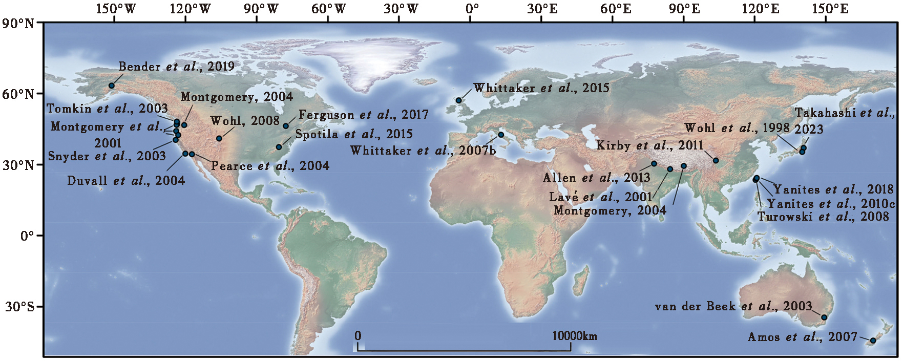
Fig. 1 Examples of global river channel width studies.
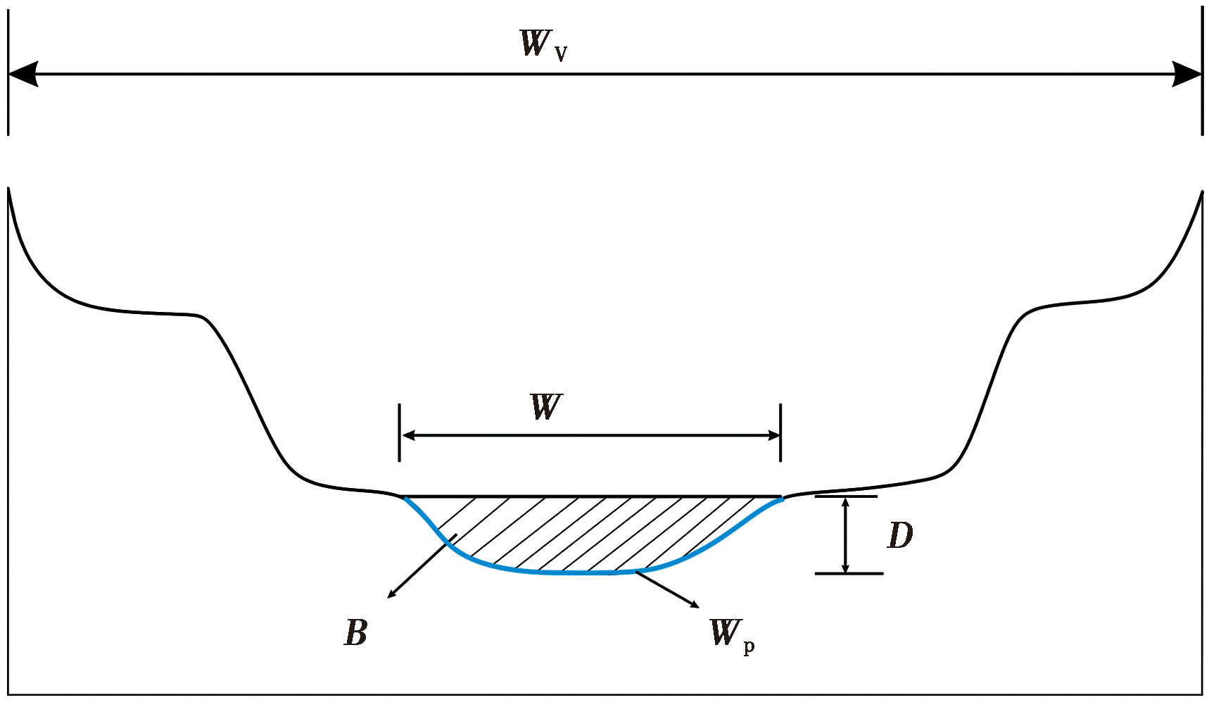
Fig. 2 River channel geometry parameters.
| 地区 | 水力几何表达式 | 文献 |
|---|---|---|
| Satsop River, 华盛顿州 | W=0.007A0.47, 基岩河道 W=0.005A0.49, 冲积河道 | Montgomery et al., |
| Willapa River, 华盛顿州 | W=0.054 7A0.32, 基岩河道 W=0.020A0.39, 冲积河道 | |
| Sullivan and Larson Creek, 俄勒冈州 | W=0.015A0.42, 基岩河道 W=0.034A0.33, 冲积河道 | |
| Knowles Creek, 俄勒冈州 | W=0.002A0.53, 基岩河道 W=0.05A0.32, 冲积河道 | |
| Yuba River, 加尼福尼亚州 | W=0.008A0.37, 基岩河道 W=0.003A0.45, 冲积河道 | |
| 门多西诺三联点, 加利福尼亚州北部 | W∝A0.4 | Snyder et al., |
| Clearwater River, 华盛顿州 | W=4.20A0.42 | Tomkin et al., |
| Lachlan River,澳大利亚东南部 | W∝0.0004A0.55, W∝0.001A0.53, W∝0.012A0.41 | van der Beek et al., |
| 圣伊内斯山脉, 加利福尼亚南部沿海地区 | W∝0.08A0.33(低抬升速率) W∝0.007A0.42(高抬升速率) W∝A0.4(全段) | Duvall et al., |
| 加利福尼亚州金山, 俄勒冈州沿海地区, 华盛顿州奥林匹克山脉, 内华达山脉, 弗吉尼亚州马里兰地区, 四川龙门山地区 | W=3.3A0.36 | Whipple, |
| 亚平宁山脉中部, 意大利 | W∝A0.35~0.5 | Whittaker et al., |
| 北港溪, 台湾 | W=0.002 3A0.5378 | Yanites et al., |
| 涪江, 四川 | W∝A0.57 | Kirby et al., |
| 杂谷脑河, 四川 | W∝A0.39 | |
| 湔江, 四川 | W∝A0.63 | |
| 黑水河、岷江, 四川 | W∝A0.36 | |
| San Gabriel Mountains, 加利福尼亚州 | W=3.18A0.27(低起伏度区域) W=4.06A0.22(高起伏度区域) | DiBiase et al., |
| 上西瓦利克山, 喜马拉雅山脉 | W∝A0.36 | Allen et al., |
| 中西瓦利克山, 喜马拉雅山脉 | W∝A0.72 | |
| 苏格兰高地地区 | W=4.54A0.3, 基岩河道 W=4.61A0.41, 冲积河道 | Whitbread et al., |
| Ontario and Québec, 加拿大 | W=6.62A0.4 | Ferguson et al., |
Table1 Hydraulic Geometry Coefficients of River Channel Width for Different Regions (modified from Wohl et al., 2008)
| 地区 | 水力几何表达式 | 文献 |
|---|---|---|
| Satsop River, 华盛顿州 | W=0.007A0.47, 基岩河道 W=0.005A0.49, 冲积河道 | Montgomery et al., |
| Willapa River, 华盛顿州 | W=0.054 7A0.32, 基岩河道 W=0.020A0.39, 冲积河道 | |
| Sullivan and Larson Creek, 俄勒冈州 | W=0.015A0.42, 基岩河道 W=0.034A0.33, 冲积河道 | |
| Knowles Creek, 俄勒冈州 | W=0.002A0.53, 基岩河道 W=0.05A0.32, 冲积河道 | |
| Yuba River, 加尼福尼亚州 | W=0.008A0.37, 基岩河道 W=0.003A0.45, 冲积河道 | |
| 门多西诺三联点, 加利福尼亚州北部 | W∝A0.4 | Snyder et al., |
| Clearwater River, 华盛顿州 | W=4.20A0.42 | Tomkin et al., |
| Lachlan River,澳大利亚东南部 | W∝0.0004A0.55, W∝0.001A0.53, W∝0.012A0.41 | van der Beek et al., |
| 圣伊内斯山脉, 加利福尼亚南部沿海地区 | W∝0.08A0.33(低抬升速率) W∝0.007A0.42(高抬升速率) W∝A0.4(全段) | Duvall et al., |
| 加利福尼亚州金山, 俄勒冈州沿海地区, 华盛顿州奥林匹克山脉, 内华达山脉, 弗吉尼亚州马里兰地区, 四川龙门山地区 | W=3.3A0.36 | Whipple, |
| 亚平宁山脉中部, 意大利 | W∝A0.35~0.5 | Whittaker et al., |
| 北港溪, 台湾 | W=0.002 3A0.5378 | Yanites et al., |
| 涪江, 四川 | W∝A0.57 | Kirby et al., |
| 杂谷脑河, 四川 | W∝A0.39 | |
| 湔江, 四川 | W∝A0.63 | |
| 黑水河、岷江, 四川 | W∝A0.36 | |
| San Gabriel Mountains, 加利福尼亚州 | W=3.18A0.27(低起伏度区域) W=4.06A0.22(高起伏度区域) | DiBiase et al., |
| 上西瓦利克山, 喜马拉雅山脉 | W∝A0.36 | Allen et al., |
| 中西瓦利克山, 喜马拉雅山脉 | W∝A0.72 | |
| 苏格兰高地地区 | W=4.54A0.3, 基岩河道 W=4.61A0.41, 冲积河道 | Whitbread et al., |
| Ontario and Québec, 加拿大 | W=6.62A0.4 | Ferguson et al., |

Fig. 3 Results of the study of river channel morphology in Siwaliks, India(modified from Allen et al., 2013).
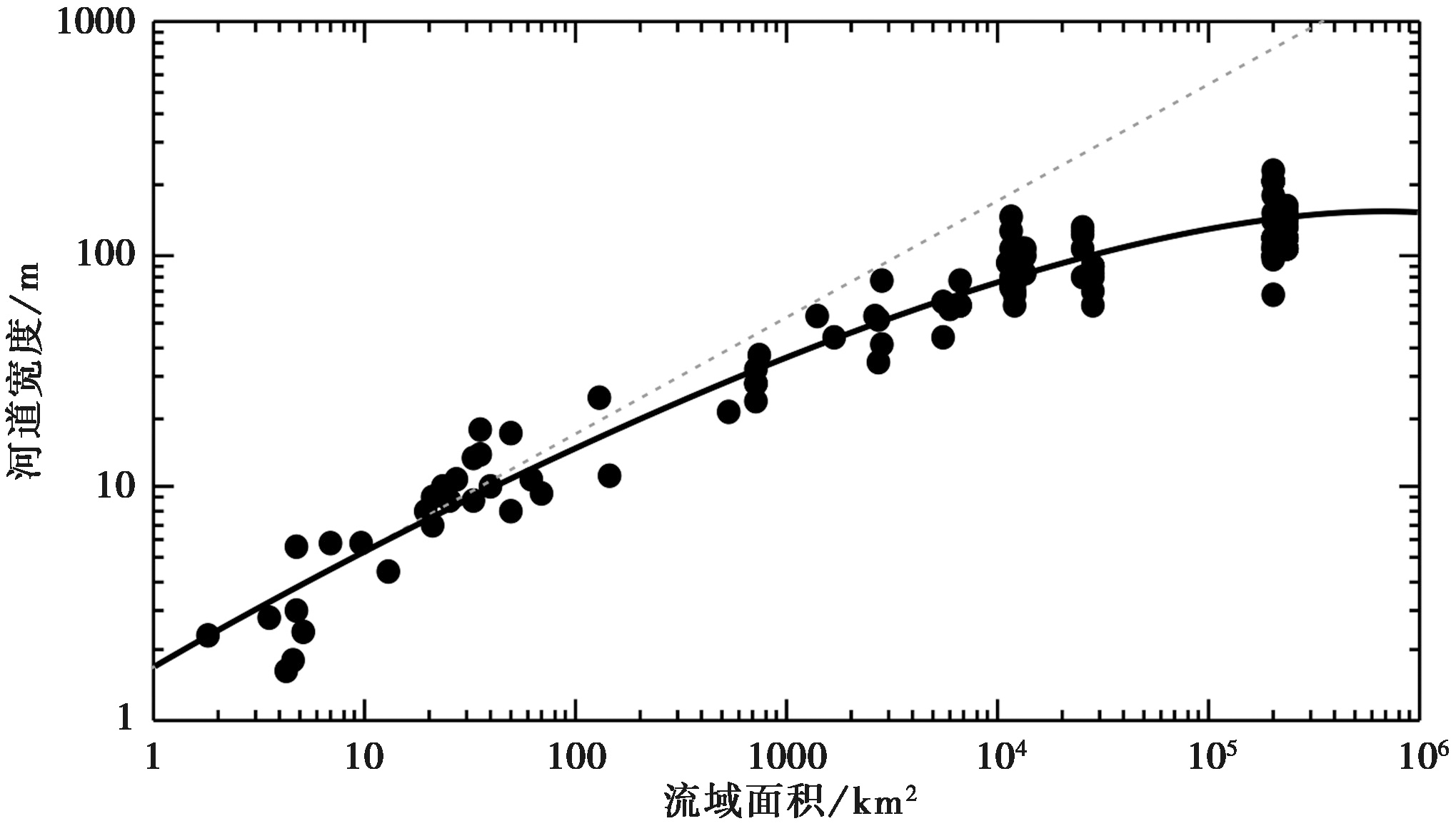
Fig. 4 Plot of river channel width versus drainage area in the Namcha Barwa Canyon, Yarlung Tsangpo(modified from Montgomery, 2004).
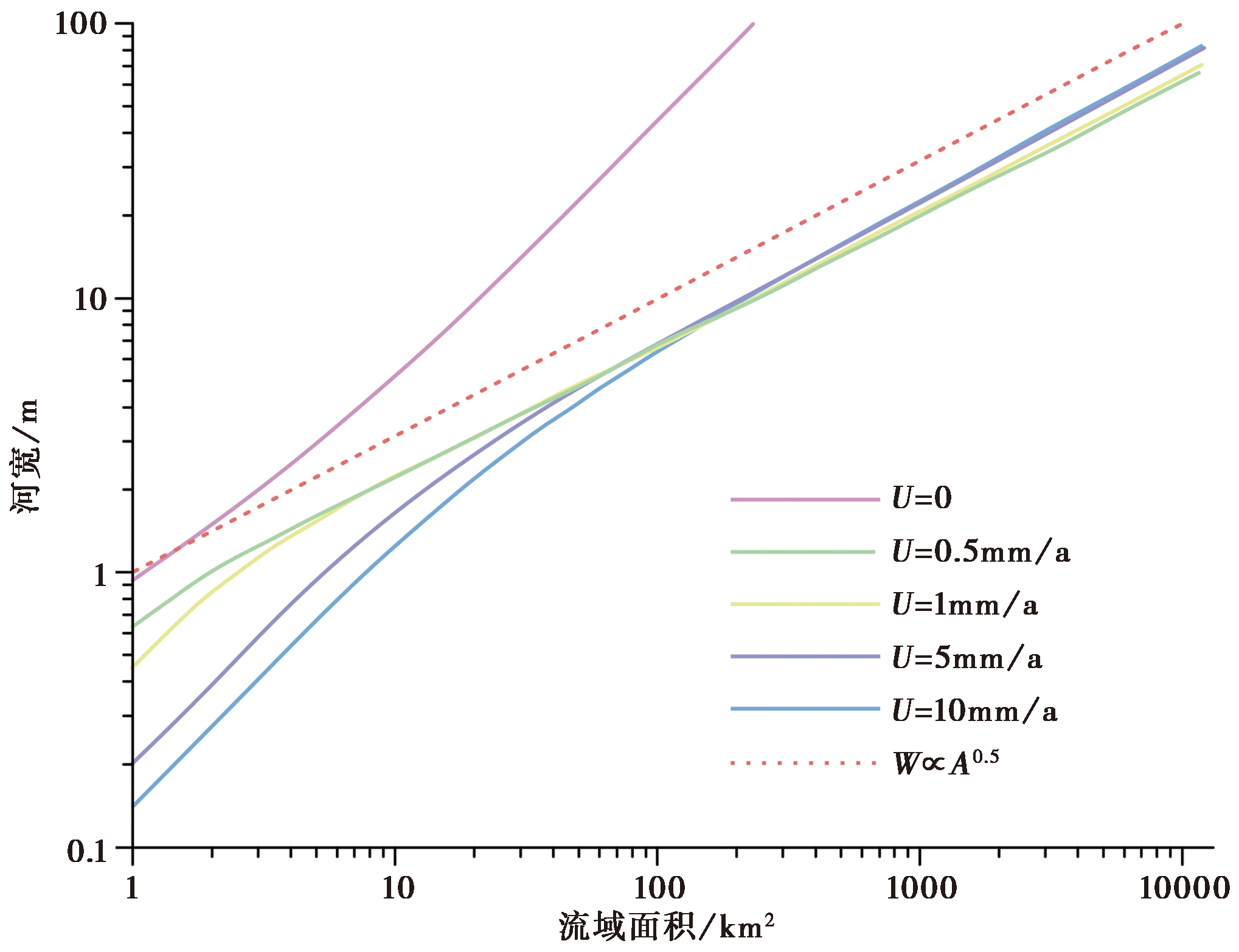
Fig. 5 Plot of river channel width versus drainage area under different uplift rates (modified from Turowski et al., 2007b).
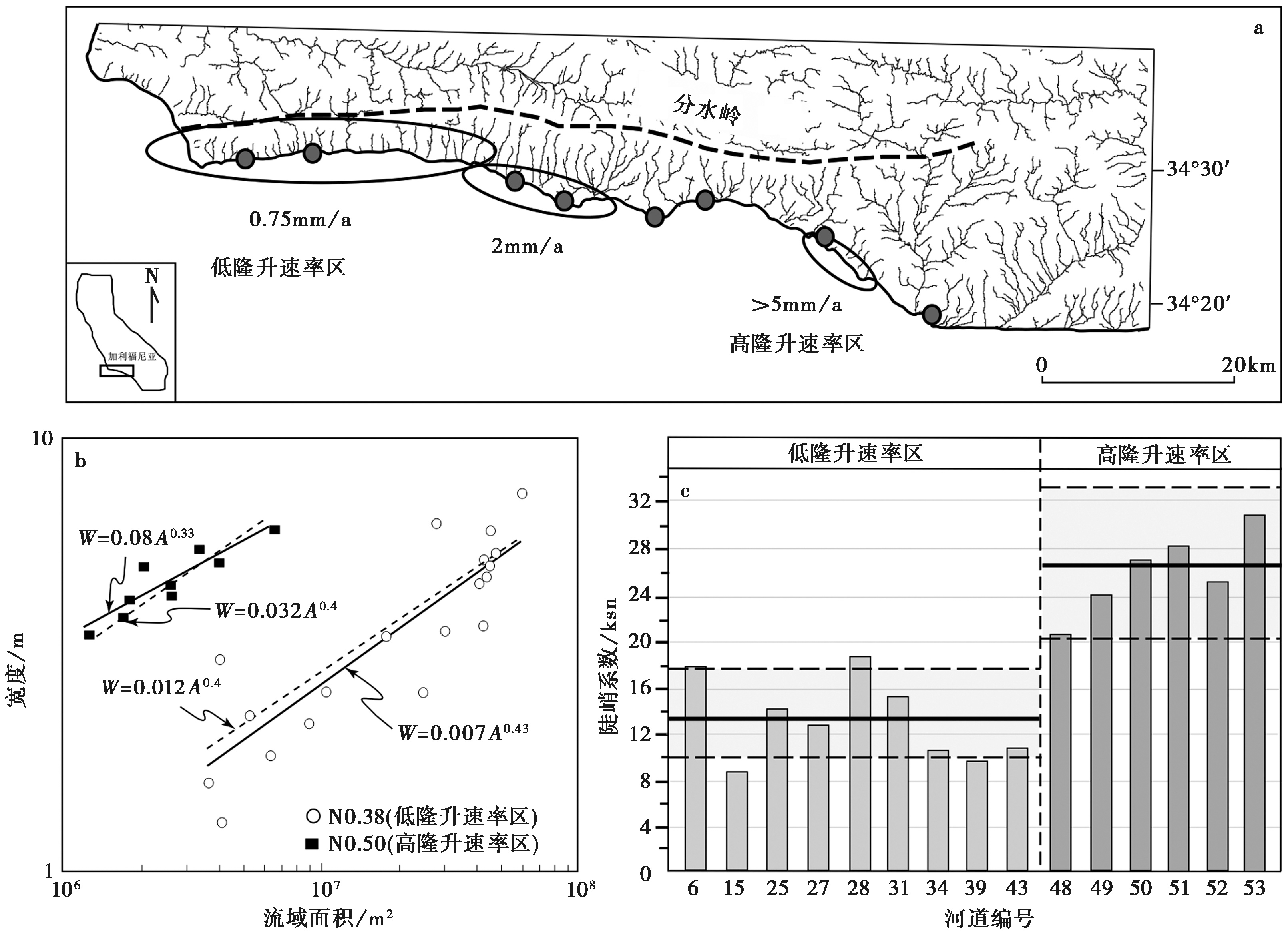
Fig. 6 Results of river channel width analysis in the Santa Ynez Mountains along the south coast of California(modified from Duvall et al., 2004).
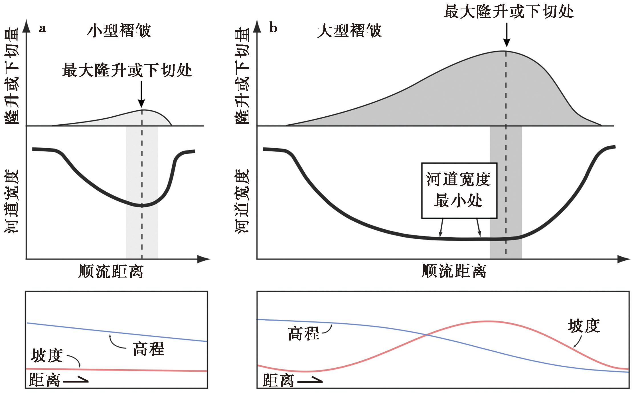
Fig. 7 Conceptual diagram of river channel width response to active folding(modified from Amos et al., 2007).
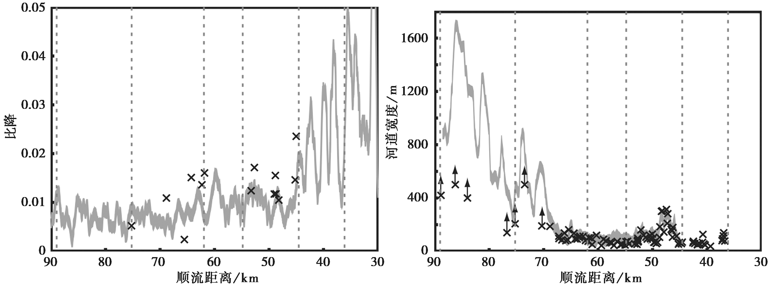
Fig. 8 Downstream trends of channel gradient and width in the Peikang River, Taiwan, China(modified from Yanites et al., 2010c).
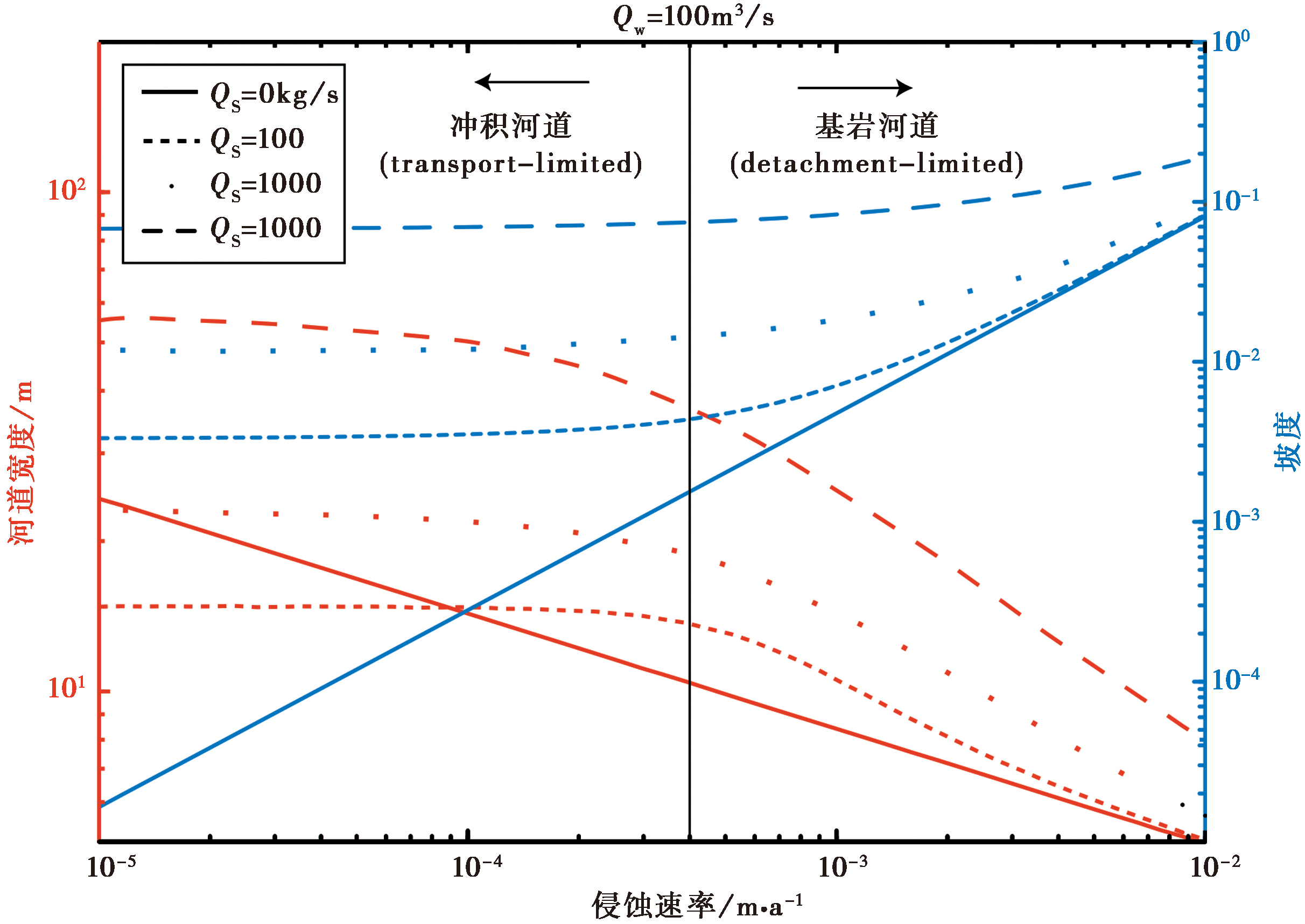
Fig. 9 Plot of river channel width and slope variation patterns against erosion rate under different sediment fluxes(modified from Yanites et al., 2010a).
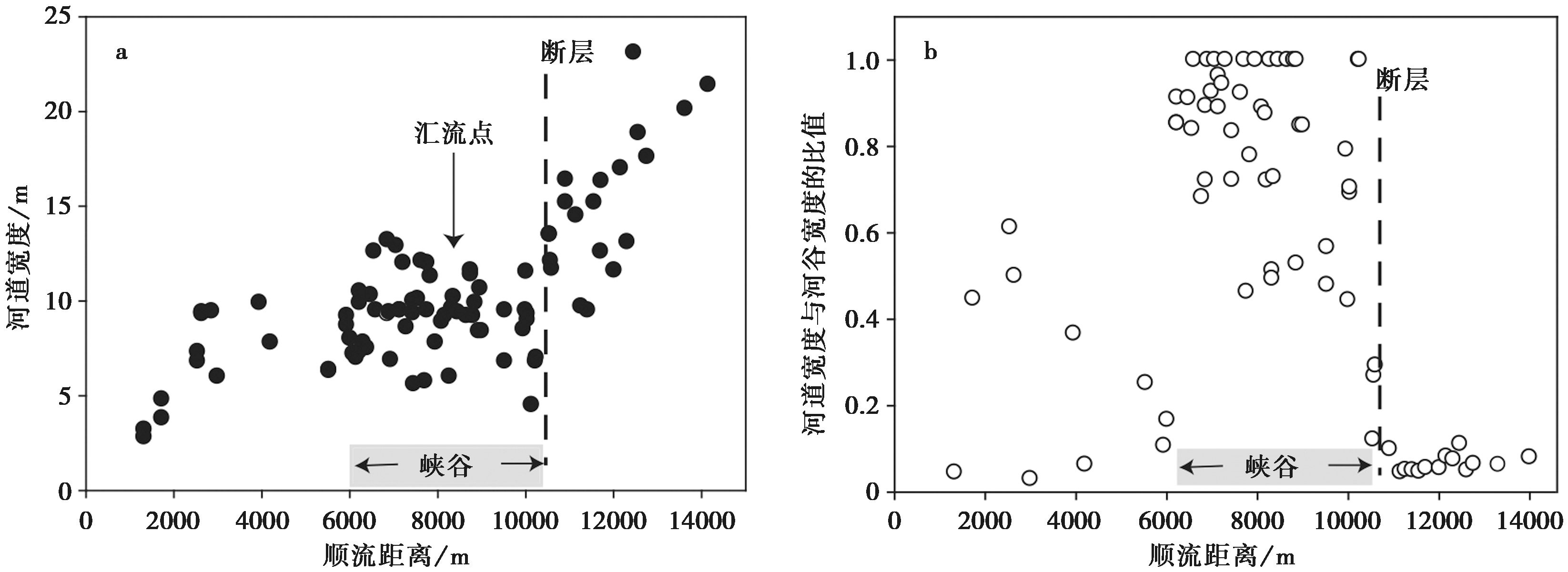
Fig. 10 Downstream trends of bankfull width in the Rio Torto(a); Downstream trend of the channel-to-valley width ratio(b)(modified from Whittaker et al., 2007a).
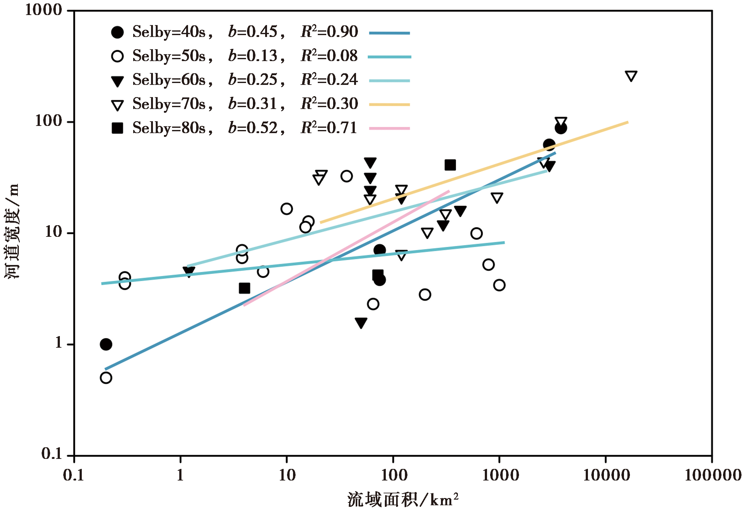
Fig. 11 Regression of hydraulic geometry coefficients for river channels categorized by Selby rock mass strength(modified from Wohl et al., 2008).
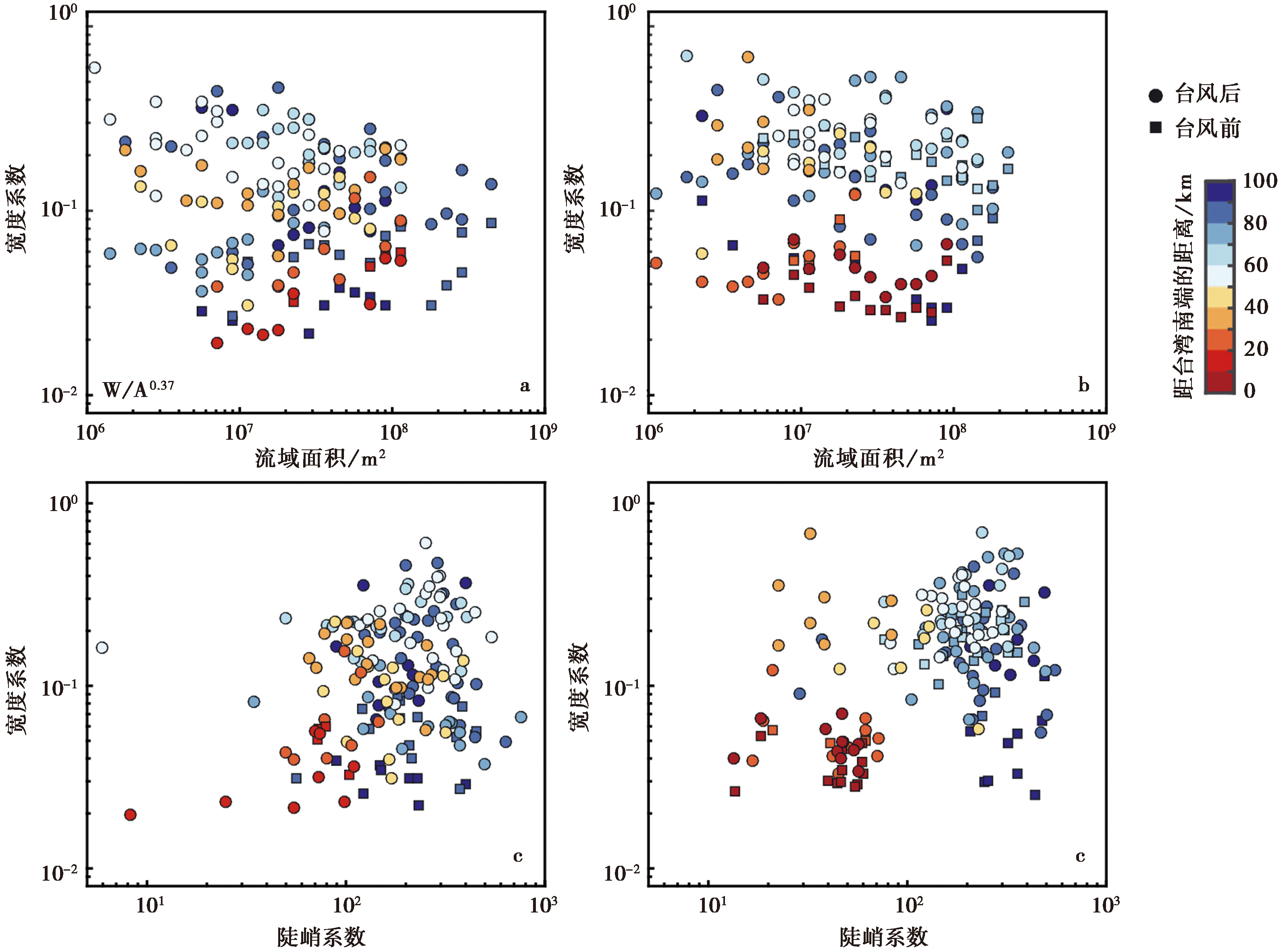
Fig. 12 Changes in channel morphology in Taiwan, China induced by Typhoon Morakot(modified from Yanites et al., 2018).
| [1] |
DOI URL |
| [2] |
DOI URL |
| [3] |
|
| [4] |
DOI URL |
| [5] |
|
| [6] |
|
| [7] |
DOI URL |
| [8] |
DOI URL |
| [9] |
DOI |
| [10] |
DOI URL |
| [11] |
|
| [12] |
PMID |
| [13] |
DOI |
| [14] |
|
| [15] |
DOI URL |
| [16] |
DOI URL |
| [17] |
|
| [18] |
|
| [19] |
DOI URL |
| [20] |
|
| [21] |
DOI URL |
| [22] |
DOI URL |
| [23] |
|
| [24] |
|
| [25] |
|
| [26] |
DOI URL |
| [27] |
DOI |
| [28] |
DOI URL |
| [29] |
DOI URL |
| [30] |
DOI URL |
| [31] |
|
| [32] |
DOI URL |
| [33] |
|
| [34] |
DOI |
| [35] |
|
| [36] |
DOI URL |
| [37] |
|
| [38] |
DOI URL |
| [39] |
DOI URL |
| [40] |
DOI URL |
| [41] |
DOI URL |
| [42] |
DOI URL |
| [43] |
DOI URL |
| [44] |
DOI URL |
| [45] |
|
| [46] |
DOI URL |
| [47] |
|
| [48] |
DOI URL |
| [49] |
DOI URL |
| [50] |
PMID |
| [51] |
DOI URL |
| [52] |
DOI URL |
| [53] |
DOI URL |
| [54] |
DOI URL |
| [55] |
DOI URL |
| [56] |
DOI URL |
| [57] |
DOI URL |
| [58] |
DOI URL |
| [59] |
DOI URL |
| [60] |
|
| [61] |
DOI URL |
| [62] |
DOI URL |
| [63] |
DOI URL |
| [64] |
DOI URL |
| [65] |
DOI URL |
| [66] |
DOI URL |
| [67] |
|
| [68] |
DOI URL |
| [69] |
|
| [70] |
DOI URL |
| [71] |
DOI URL |
| [72] |
DOI |
| [73] |
|
| [74] |
|
| [75] |
|
| [76] |
|
| [77] |
|
| [78] |
DOI URL |
| [79] |
DOI URL |
| [80] |
DOI URL |
| [81] |
|
| [82] |
|
| [83] |
|
| [84] |
DOI URL |
| [85] |
DOI URL |
| [86] |
DOI URL |
| [87] |
DOI URL |
| [88] |
DOI URL |
| [89] |
DOI URL |
| [90] |
DOI URL |
| [91] |
|
| [92] |
DOI URL |
| [93] |
DOI URL |
| [94] |
|
| [95] |
DOI URL |
| [96] |
|
| [97] |
DOI URL |
| [98] |
DOI URL |
| [99] |
|
| [100] |
DOI URL |
| [101] |
|
| [102] |
DOI URL |
| [103] |
DOI URL |
| [104] |
DOI URL |
| [105] |
DOI URL |
| [106] |
DOI URL |
| [107] |
DOI URL |
| [108] |
PMID |
| [109] |
DOI URL |
| [110] |
|
| [111] |
DOI URL |
| [112] |
DOI PMID |
| [113] |
DOI URL |
| [114] |
DOI URL |
| [115] |
DOI URL |
| [116] |
|
| [117] |
DOI URL |
| [118] |
|
| [119] |
DOI PMID |
| [120] |
|
| [121] |
DOI URL |
| [122] |
DOI URL |
| [123] |
DOI URL |
| [124] |
|
| [125] |
|
| [126] |
DOI PMID |
| [127] |
DOI URL |
| [128] |
DOI URL |
| [129] |
DOI URL |
| [130] |
|
| [131] |
|
| [132] |
DOI URL |
| [133] |
DOI URL |
| [134] |
|
| [135] |
|
| [136] |
|
| [137] |
|
| [138] |
|
| [139] |
DOI URL |
| [140] |
DOI URL |
| [141] |
|
| [142] |
DOI URL |
| [143] |
|
| [144] |
|
| [145] |
DOI URL |
| [146] |
DOI URL |
| [147] |
DOI URL |
| [148] |
DOI URL |
| [149] |
DOI URL |
| [150] |
DOI URL |
| [151] |
|
| [152] |
|
| [153] |
|
| [154] |
DOI URL |
| [155] |
|
| [156] |
DOI URL |
| [157] |
|
| [158] |
DOI URL |
| [159] |
DOI URL |
| [160] |
|
| [161] |
DOI URL |
| [162] |
DOI URL |
| [163] |
DOI URL |
| [164] |
DOI URL |
| [165] |
|
| [166] |
DOI URL |
| [167] |
DOI URL |
| [168] |
|
| [169] |
|
| [1] | LU Ben-tian, LI Zhi-gang, LIANG Hao, YANG Jing-jun, ZHENG Wen-jun. THE RESPONSE OF FLUVIAL LANDFORM TO THE EVOLU-TION OF FAULT STRUCTURE IN THE NORTHERN ZHONGTIAO MOUNTAINS FAULT [J]. SEISMOLOGY AND GEOLOGY, 2022, 44(4): 961-975. |
| Viewed | ||||||
|
Full text |
|
|||||
|
Abstract |
|
|||||
Copyright © SEISMOLOGY AND GEOLOGY, All Rights Reserved.
Tel: 010-62009049/9063 E-mail: dzdz@ies.ac.cn
Powered by Beijing Magtech Co., Ltd.