地震地质 ›› 2021, Vol. 43 ›› Issue (4): 1013-1029.DOI: 10.3969/j.issn.0253-4967.2021.04.018
杜浩国1)( ), 林旭川2),*(), 张建国1), 杜浩标3), 张方浩1), 杜竹泉4), 卢永坤1), 代博洋5)
收稿日期:2021-05-31
修回日期:2021-06-20
出版日期:2021-08-20
发布日期:2021-09-29
通讯作者:
林旭川
作者简介:杜浩国, 男, 1991年生, 2015年于东北大学获通信工程专业学士学位, 主要从事地震应急救援、 地震灾害损失评估研究, E-mail: 1364125834@qq.com。
基金资助:
DU Hao-guo1)(), LIN Xu-chuan2),*(), ZHANG Jian-guo1), DU Hao-biao3), ZHANG Fang-hao1), DU Zhu-quan4), LU Yong-kun1), DAI Bo-yang5)
Received:2021-05-31
Revised:2021-06-20
Online:2021-08-20
Published:2021-09-29
Contact:
LIN Xu-chuan
摘要:
地震后及时、 精准地获取区域的震害情况, 对科学有效地开展应急救援与灾害损失评估工作具有重要意义。 文中依托蚁群算法以及无人机高清遥感影像, 提出了一种高效识别区域建筑震害的新方法, 并在近期云南漾濞6.4级地震的应急工作中进行了应用与验证。 该方法通过改进蚁群算法中信息素浓度更新策略, 引入优化算子, 建立了更好的识别规则, 提高了震害识别的速度与准确性; 云南漾濞6.4级地震发生后, 以第一时间获取的漾濞县城无人机高分辨率影像为试验数据, 对区域震害的提取效果进行了验证, 并与蚁群算法及最大似然方法进行对比分析。 结果表明, 文中提出的基于改进蚁群算法与无人机高分辨率影像的震害识别方法可有效提高区域内被破坏建筑物的识别精度。
中图分类号:
杜浩国, 林旭川, 张建国, 杜浩标, 张方浩, 杜竹泉, 卢永坤, 代博洋. 基于改进蚁群算法与无人机影像的震害识别方法及其在漾濞地震中的应用[J]. 地震地质, 2021, 43(4): 1013-1029.
DU Hao-guo, LIN Xu-chuan, ZHANG Jian-guo, DU Hao-biao, ZHANG Fang-hao, DU Zhu-quan, LU Yong-kun, DAI Bo-yang. A SEISMIC DAMAGE IDENTIFICATION METHOD BASED ON IMPROVED ANT COLONY ALGORITHM AND UNMANNED AERIAL VEHICLE IMAGES AND ITS APPLICATION TO YANGBI EARTHQUAKE[J]. SEISMOLOGY AND EGOLOGY, 2021, 43(4): 1013-1029.
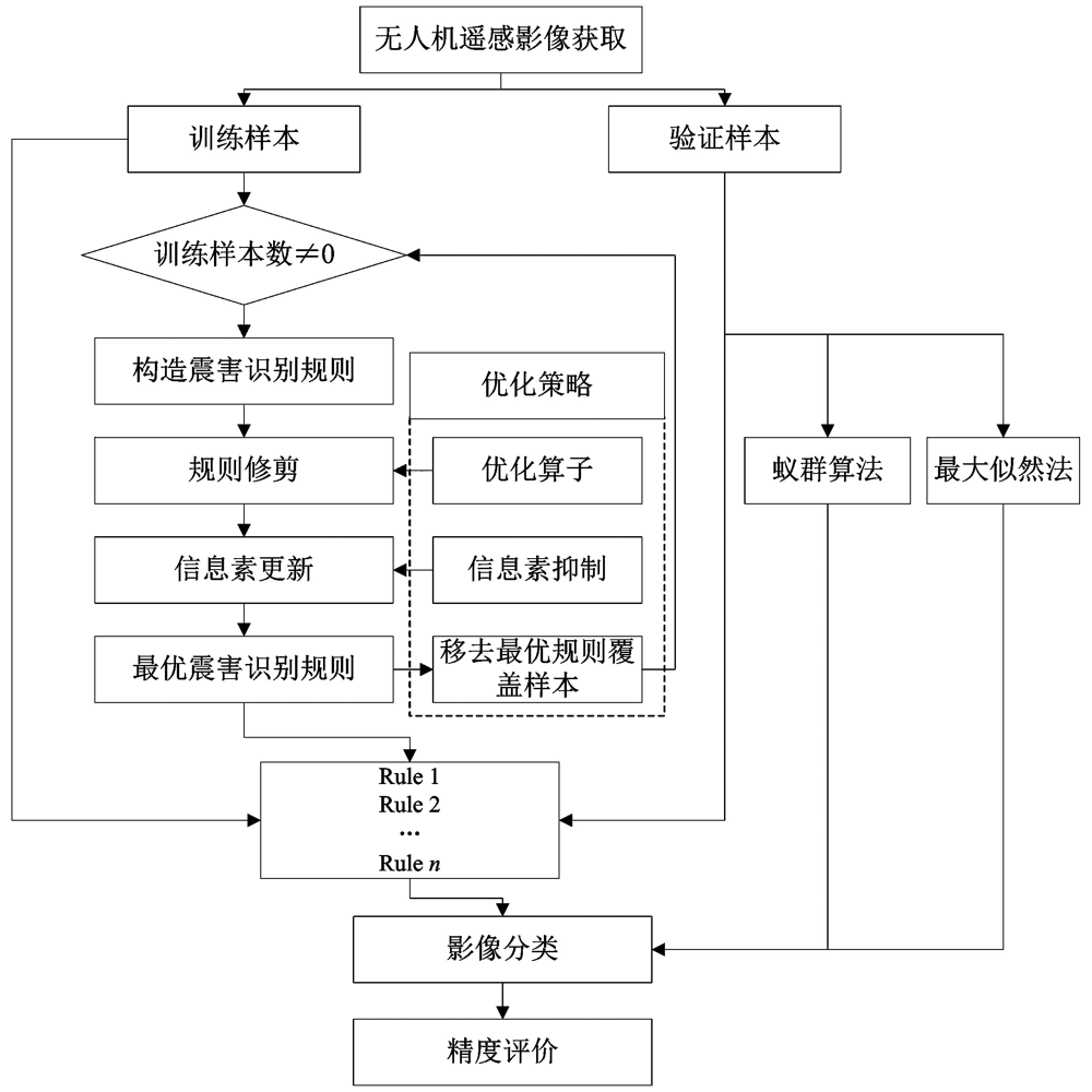
图1 基于改进蚁群算法的高分辨率影像震害识别流程图
Fig. 1 The flowchart of earthquake damage identification based on improved ant colony algorithm.
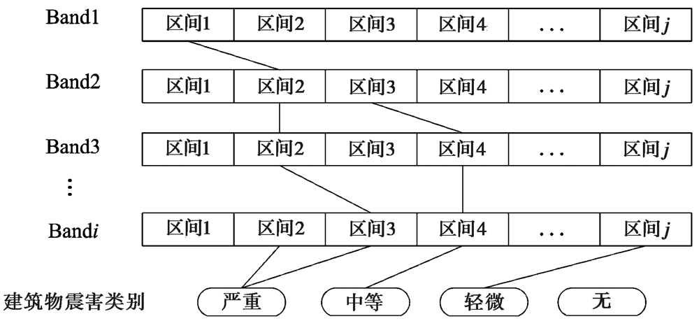
图2 识别规则对应的路径
Fig. 2 Route corresponding to classification rule.
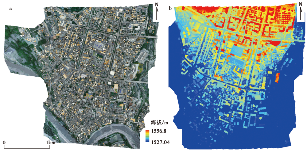
图3 a 漾濞县城无人机影像图; b 漾濞县城数字表面模型
Fig. 3 The UAV image(a) and the DSM(b) of Yangbi county seat.
| 飞行器性能 | 技术参数 | 飞行器性能 | 技术参数 |
|---|---|---|---|
| 型号 | 精灵4多光谱版 | 航拍架次 | 4架次 |
| 总重量 | 1 487g | 航向重叠度 | 70% |
| 飞行升限 | 200m | 旁向重叠图 | 65% |
| 续航时间 | ≤27min | 成像总面积 | 2km2 |
| 悬停精度 | 垂直方向±0.1m 水平方向±0.1m | 照片格式 | JPEG(可见光成像) TIFF(多光谱成像) |
| 倾斜角度 | -88° | 航拍照片数量 | 918张 |
| 飞行速度 | ≥20km/h | 单色传感器增益 | 1~8倍 |
| 影像传感器 | 6个1/2.9英寸CMOS, 包括1个用于可见光成像的彩色传感器和5个用于多光谱成像的单色传感器 | 滤光片 | 蓝(B): (450±16)nm 绿(G): (560±16)nm 红(R): (650±16)nm 红边(RE): (730±16)nm 近红外(NIR): (840±26)nm |
表1 多光谱影像采集设备参数
Table1 Multispectral image acquisition equipment parameters
| 飞行器性能 | 技术参数 | 飞行器性能 | 技术参数 |
|---|---|---|---|
| 型号 | 精灵4多光谱版 | 航拍架次 | 4架次 |
| 总重量 | 1 487g | 航向重叠度 | 70% |
| 飞行升限 | 200m | 旁向重叠图 | 65% |
| 续航时间 | ≤27min | 成像总面积 | 2km2 |
| 悬停精度 | 垂直方向±0.1m 水平方向±0.1m | 照片格式 | JPEG(可见光成像) TIFF(多光谱成像) |
| 倾斜角度 | -88° | 航拍照片数量 | 918张 |
| 飞行速度 | ≥20km/h | 单色传感器增益 | 1~8倍 |
| 影像传感器 | 6个1/2.9英寸CMOS, 包括1个用于可见光成像的彩色传感器和5个用于多光谱成像的单色传感器 | 滤光片 | 蓝(B): (450±16)nm 绿(G): (560±16)nm 红(R): (650±16)nm 红边(RE): (730±16)nm 近红外(NIR): (840±26)nm |
| 序号 | 震害等级 | 训练样本 | 验证样本 |
|---|---|---|---|
| 1 | 严重 | 217 | 404 |
| 2 | 中度 | 1 094 | 441 |
| 3 | 轻度 | 120 | 372 |
| 4 | 无破坏 | 250 | 831 |
| 合计 | 1 680 | 2 048 |
表2 训练样本和验证样本
Table2 The training data and test data samples
| 序号 | 震害等级 | 训练样本 | 验证样本 |
|---|---|---|---|
| 1 | 严重 | 217 | 404 |
| 2 | 中度 | 1 094 | 441 |
| 3 | 轻度 | 120 | 372 |
| 4 | 无破坏 | 250 | 831 |
| 合计 | 1 680 | 2 048 |
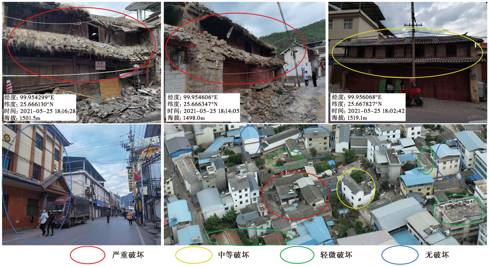
图4 部分训练样本的实地调研影像
Fig. 4 The field survey images of some training samples.
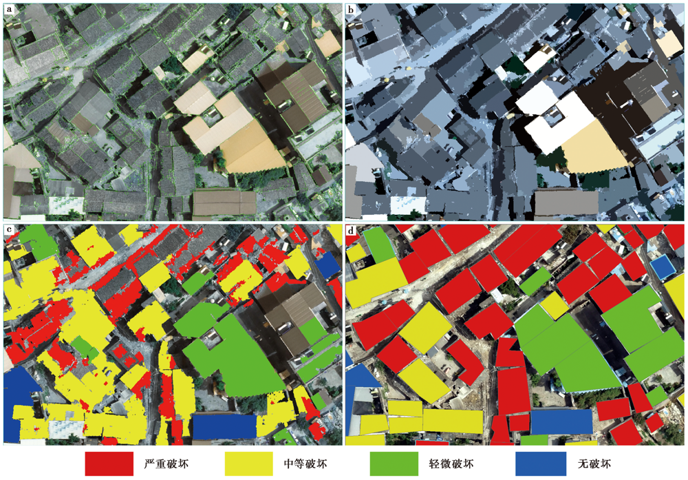
图5 a 建筑物轮廓检测结果; b 建筑物灰度化结果; c 建筑物损坏识别结果; d 建筑物震害等级识别结果
Fig. 5 Building contour test results(a), building grayscale results(b), building damage identification results(c), and identification result of building earthquake damage grade(d).
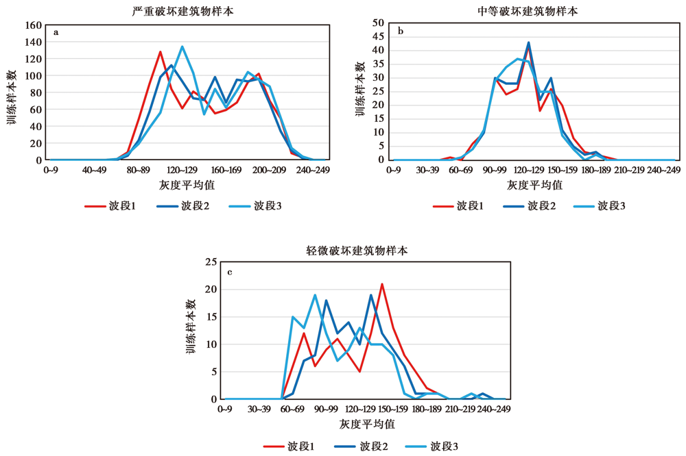
图6 训练样本的平均灰度值与建筑物数量统计
Fig. 6 The average grayscale value of training samples and building number statistics.
| 改进的蚁群算法 | 蚁群算法 | ||
|---|---|---|---|
| 规则1: | if 110<B1 and B2<120 and 100<B3 then 严重破坏 | 规则1: | if 110<B1<119 and 140<B2<149 and 120<B3<129 then 严重破坏 |
| 规则2: | if 110<B1 and 120<B3 then 中等破坏 | 规则2: | if 190<B1<199 and 100<B2<109 and 190<B3<199 then 中等破坏 |
| 规则3: | if 140<B1 and 130<B2 and B3<89 then 轻微破坏 | 规则3: | if 150<B1<159 and 90<B2<99 and 60<B3<69 then 轻微破坏 |
| 规则19: | if 100<B1 and 100<B2<159 and 120<B3 then 中等破坏 | 规则35: | if 180<B1<189 and 150<B2<99 and 60<B3<150 then 中等破坏 |
| 规则20: | if 99<B2<129 and B3<129 then 严重破坏 | 规则36: | if 90<B1<99 and 140<B2<149 and 120<B3<129 then 严重破坏 |
表3 改进的蚁群算法和蚁群算法挖掘的部分识别规则
Table3 Part of classification rules from improved ant colony algorithm and ant-miner algorithm
| 改进的蚁群算法 | 蚁群算法 | ||
|---|---|---|---|
| 规则1: | if 110<B1 and B2<120 and 100<B3 then 严重破坏 | 规则1: | if 110<B1<119 and 140<B2<149 and 120<B3<129 then 严重破坏 |
| 规则2: | if 110<B1 and 120<B3 then 中等破坏 | 规则2: | if 190<B1<199 and 100<B2<109 and 190<B3<199 then 中等破坏 |
| 规则3: | if 140<B1 and 130<B2 and B3<89 then 轻微破坏 | 规则3: | if 150<B1<159 and 90<B2<99 and 60<B3<69 then 轻微破坏 |
| 规则19: | if 100<B1 and 100<B2<159 and 120<B3 then 中等破坏 | 规则35: | if 180<B1<189 and 150<B2<99 and 60<B3<150 then 中等破坏 |
| 规则20: | if 99<B2<129 and B3<129 then 严重破坏 | 规则36: | if 90<B1<99 and 140<B2<149 and 120<B3<129 then 严重破坏 |
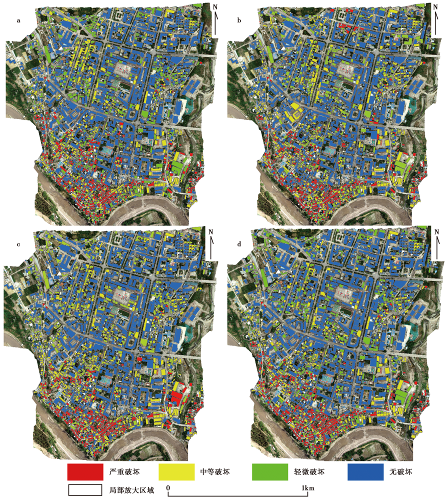
图7 a 改进的蚁群算法震害识别结果图; b 蚁群算法震害识别结果图; c 最大似然法震害识别结果图; d 目视解译结果
Fig. 7 Seismic damage identification results of improved ant colony algorithm(a), seismic damage identification results of ant colony algorithm(b), seismic damage identification results of maximum likelihood method(c), and visual interpretation results(d).
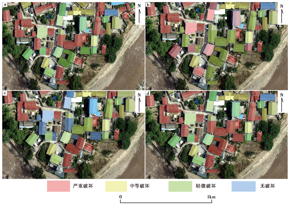
图8 a 改进的蚁群算法震害识别局部放大; b 蚁群算法震害识别局部放大; c 最大似然法震害识别局部放大; d 目视解译局部放大
Fig. 8 An improved ant colony algorithm for local amplification of seismic damage identification(a), ant colony algorithm for seismic damage identification local amplification(b), local amplification of earthquake damage identification by maximum likelihood method(c), and local magnification of visual interpretation(d).
| 震害识别等级 | 严重破坏/栋 | 中等破坏/栋 | 轻微破坏/栋 | 无破坏/栋 | 总和 | 生产精度/% |
|---|---|---|---|---|---|---|
| 严重破坏 | 353 | 15 | 8 | 18 | 394 | 89.59 |
| 中等破坏 | 13 | 384 | 21 | 21 | 439 | 87.47 |
| 轻微破坏 | 21 | 31 | 320 | 13 | 385 | 83.11 |
| 无破坏 | 17 | 11 | 23 | 779 | 830 | 93.85 |
| 总和 | 404 | 441 | 372 | 831 | 2 048 | |
| 使用精度/% | 87.37 | 87.07 | 86.02 | 93.74 | ||
| 总体精度 | 89.64% | Kappa系数 | 0.855 |
表4 漾濞县城区基于改进的蚁群优化算法震害识别精度评价结果
Table4 Accuracy evaluation results of seismic damage identification of Yangbi county seat based on improved ant colony optimization algorithm
| 震害识别等级 | 严重破坏/栋 | 中等破坏/栋 | 轻微破坏/栋 | 无破坏/栋 | 总和 | 生产精度/% |
|---|---|---|---|---|---|---|
| 严重破坏 | 353 | 15 | 8 | 18 | 394 | 89.59 |
| 中等破坏 | 13 | 384 | 21 | 21 | 439 | 87.47 |
| 轻微破坏 | 21 | 31 | 320 | 13 | 385 | 83.11 |
| 无破坏 | 17 | 11 | 23 | 779 | 830 | 93.85 |
| 总和 | 404 | 441 | 372 | 831 | 2 048 | |
| 使用精度/% | 87.37 | 87.07 | 86.02 | 93.74 | ||
| 总体精度 | 89.64% | Kappa系数 | 0.855 |
| 震害识别等级 | 严重破坏/栋 | 中等破坏/栋 | 轻微破坏/栋 | 无破坏/栋 | 总和 | 生产精度/% |
|---|---|---|---|---|---|---|
| 严重破坏 | 352 | 20 | 8 | 24 | 404 | 87.13 |
| 中等破坏 | 15 | 370 | 23 | 19 | 427 | 86.65 |
| 轻微破坏 | 22 | 33 | 323 | 15 | 393 | 82.18 |
| 无破坏 | 15 | 18 | 18 | 773 | 824 | 93.81 |
| 总和 | 404 | 441 | 372 | 831 | 2 048 | |
| 使用精度/% | 87.12 | 83.9 | 86.82 | 93.02 | ||
| 总体精度 | 88.76% | Kappa系数 | 0.843 |
表5 漾濞县城区基于蚁群算法震害识别精度评价结果
Table5 Evaluation results of earthquake damage identification of Yangbi county seat based on ant colony algorithm
| 震害识别等级 | 严重破坏/栋 | 中等破坏/栋 | 轻微破坏/栋 | 无破坏/栋 | 总和 | 生产精度/% |
|---|---|---|---|---|---|---|
| 严重破坏 | 352 | 20 | 8 | 24 | 404 | 87.13 |
| 中等破坏 | 15 | 370 | 23 | 19 | 427 | 86.65 |
| 轻微破坏 | 22 | 33 | 323 | 15 | 393 | 82.18 |
| 无破坏 | 15 | 18 | 18 | 773 | 824 | 93.81 |
| 总和 | 404 | 441 | 372 | 831 | 2 048 | |
| 使用精度/% | 87.12 | 83.9 | 86.82 | 93.02 | ||
| 总体精度 | 88.76% | Kappa系数 | 0.843 |
| 震害识别等级 | 严重破坏/栋 | 中等破坏/栋 | 轻微破坏/栋 | 无破坏/栋 | 总和 | 生产精度/% |
|---|---|---|---|---|---|---|
| 严重破坏 | 324 | 21 | 15 | 27 | 387 | 83.72 |
| 中等破坏 | 39 | 363 | 23 | 25 | 450 | 80.66 |
| 轻微破坏 | 24 | 33 | 315 | 35 | 407 | 77.39 |
| 无破坏 | 17 | 24 | 19 | 744 | 804 | 92.53 |
| 总和 | 404 | 441 | 372 | 831 | 2 048 | |
| 使用精度/% | 80.19 | 82.31 | 84.67 | 89.53 | ||
| 总体精度 | 85.25% | Kappa系数 | 0.795 |
表6 漾濞县城区基于最大似然法震害识别精度评价结果
Table6 Accuracy evaluation results of earthquake damage identification of Yangbi county seat based on maximum likelihood method
| 震害识别等级 | 严重破坏/栋 | 中等破坏/栋 | 轻微破坏/栋 | 无破坏/栋 | 总和 | 生产精度/% |
|---|---|---|---|---|---|---|
| 严重破坏 | 324 | 21 | 15 | 27 | 387 | 83.72 |
| 中等破坏 | 39 | 363 | 23 | 25 | 450 | 80.66 |
| 轻微破坏 | 24 | 33 | 315 | 35 | 407 | 77.39 |
| 无破坏 | 17 | 24 | 19 | 744 | 804 | 92.53 |
| 总和 | 404 | 441 | 372 | 831 | 2 048 | |
| 使用精度/% | 80.19 | 82.31 | 84.67 | 89.53 | ||
| 总体精度 | 85.25% | Kappa系数 | 0.795 |
| [1] | 邓飞, 窦爱霞, 王晓青. 2018. 融合航空影像的震后机载LiDAR建筑物点云提取[J]. 遥感学报, 22(S1): 224-232. |
| DENG Fei, DOU Ai-xia, WANG Xiao-qing. 2018. Fusion of aerial imagery and airborne LiDAR data for post-earthquake building point extraction[J]. National Remote Sensing Bulletin, 22(S1): 224-232. (in Chinese) | |
| [2] | 杜浩国, 陈亮, 林旭川, 等. 2019. 云南红河县城区房屋地震灾害三维仿真模拟方法[J]. 地震研究, 42(2): 218-229. |
| DU Hao-guo, CHEN Liang, LIN Xu-chuan, et al. 2019. 3D simulation method of housing earthquake disaster in Honghe County of Yunnan[J]. Journal of Seismological Research, 42(2): 218-229. (in Chinese) | |
| [3] | 杜浩国, 林旭川, 张方浩, 等. 2021. 基于蚁群优化算法的应急避难场所选址模型研究[J]. 自然灾害学报, 30(2): 89-101. |
| DU Hao-guo, LIN Xu-chuan, ZHANG Fang-hao, et al. 2021. Study on emergency shelter location model based on ant colony optimization algorithm[J]. Journal of Natural Disasters, 30(2): 89-101. (in Chinese) | |
| [4] | 范熙伟, 聂高众, 邓砚, 等. 2017. 基于摄影测量技术的房屋提取方法: 以中国西部地区乡村为例[J]. 地震地质, 39(4): 805-818. |
| FAN Xi-wei, NIE Gao-zhong, DENG Yan, et al. 2017. The extraction of house distribution based on photogrammetry method: Taking the countryside in the west of China for example[J]. Seismology and Geology, 39(4): 805-818. (in Chinese) | |
| [5] | 何曼芸, 程英蕾, 邱浪波, 等. 2017. 一种改进顶帽变换与LBP高程纹理的城区建筑物提取算法[J]. 测绘学报, 46(9): 1116-1122, 1146. |
| HE Man-yun, CHENG Ying-lei, QIU Lang-bo, et al. 2017. An algorithm of building extraction in urban area based on improved top-hat transformations and LBP elevation texture[J]. Acta Geodaetica et Cartographica Sinica, 46(9): 1116-1122, 1146. (in Chinese) | |
| [6] | 郭建兴, 张宇翔, 姬建中, 等. 2020. 利用居民地建筑物数据和高分遥感影像评估地震烈度的方法初探[J]. 地震地质, 42(4): 968-980. |
| GUO Jian-xing, ZHANG Yu-xiang, JI Jian-zhong, et al. 2020. A preliminary study on the method of seismic intensity assessment based on residential building data and high-resolution remote sensing images[J]. Seismology and Geology, 42(4): 968-980. (in Chinese) | |
| [7] | 井然, 宫兆宁, 朱文定, 等. 2020. 多尺度SLIC-GMRF与FCNSVM联合的高分影像建筑物提取[J]. 遥感学报, 24(1): 11-26. |
| JING Ran, GONG Zhao-ning, ZHU Wen-ding, et al. 2020. Extraction of buildings from remote sensing imagery based on multi-scale SLIC-GMRF and FCNSVM[J]. National Remote Sensing Bulletin, 24(1): 11-26. (in Chinese) | |
| [8] | 刘莹, 陶超, 闫培, 等. 2017. 图割能量驱动的高分辨率遥感影像震害损毁建筑物检测[J]. 测绘学报, 46(7): 910-917. |
| LIU Ying, TAO Chao, YAN Pei, et al. 2017. Graph cut energy driven earthquake-damaged building detection from high-resolution remote sensing images[J]. Acta Geodaetica et Cartographica Sinica, 46(7): 910-917. (in Chinese) | |
| [9] | 李强, 张景发, 龚丽霞, 等. 2018. SAR图像纹理特征相关变化检测的震害建筑物提取[J]. 遥感学报, 22(S1): 128-138. |
| LI Qiang, ZHANG Jing-fa, GONG Li-xia, et al. 2018. Extraction of earthquake-collapsed buildings based on correlation change detection of multi-texture features in SAR images[J]. National Remote Sensing Bulletin, 22(S1): 128-138. (in Chinese) | |
| [10] | 宋平, 聂高众, 邓砚, 等. 2016. 基于现场调查的地震灾害损失预评估--以云南省德宏傣族景颇族自治州为例[J]. 地震地质, 38(4): 1148-1159. |
| SONG Ping, NIE Gao-zhong, DENG Yan, et al. 2016. Pre-assessment of earthquake-induced losses based on field survey and kilometer grid dataset: A case study from Dehongdai-Jingpo Autonomous Prefecture[J]. Seismology and Geology, 38(4): 1148-1159. (in Chinese) | |
| [11] | 游永发, 王思远, 王斌, 等. 2019. 高分辨率遥感影像建筑物分级提取[J]. 遥感学报, 23(1): 125-136. |
| YOU Yong-fa, WANG Si-yuan, WANG Bin, et al. 2019. Study on hierarchical building extraction from high-resolution remote sensing imagery[J]. National Remote Sensing Bulletin, 23(1): 125-136. (in Chinese) | |
| [12] | 张景发, 李强, 焦其松, 等. 2017. 建筑物震害多源遥感特征与机理分析[J]. 地震学报, 39(2): 257-272. |
| ZHANG Jing-fa, LI Qiang, JIAO Qi-song, et al. 2017. Multi-source remote sensing characteristics and mechanism analysis of building earthquake damage[J]. Acta Seismologica Sinica, 39(2): 257-272. (in Chinese) | |
| [13] | 张景发, 李强, 张庆云, 等. 2018. 多源遥感图像的1976年MS7.8唐山大地震等烈度区判定[J]. 遥感学报, 22(S1): 162-173. |
| ZHANG Jing-fa, LI Qiang, ZHANG Qing-yun, et al. 2018. Intensity zone of the 1976 MS7.8 Tangshan earthquake based on multisource remote sensing images[J]. National Remote Sensing Bulletin, 22(S1): 162-173. (in Chinese) | |
| [14] | 张凌, 谭璇, 宋冬梅, 等. 2019. 基于马尔科夫随机场的单时相震害影像受损建筑物识别方法[J]. 地震地质, 41(5): 1273-1288. |
| ZHANG Ling, TAN Xuan, SONG Dong-mei, et al. 2019. Study on the MRF-based method for damaged buildings extraction from the single-phase seismic image[J]. Seismology and Geology, 41(5): 1273-1288. (in Chinese) | |
| [15] | He N J, Fang L Y, Plaza A. 2020. Hybrid first and second order attention Unet for building segmentation in remote sensing images[J]. Science China(Information Sciences), 63(4): 69-80. |
| [16] |
Hu Y B, Zhang J, Ma Y, et al. 2019. Deep learning classification of coastal wetland hyperspectral image combined spectra and texture features: A case study of Huanghe(Yellow)River estuary wetland[J]. Acta Oceanologica Sinica, 38(5): 142-150.
DOI URL |
| [17] |
Guo H D, Chen Y, Feng Q, et al. 2011. Assessment of damage to buildings and farms during the 2011 M9.0 earthquake and tsunami in Japan from remote sensing data[J]. Chinese Science Bulletin, 56(20): 2138-2144.
DOI URL |
| [18] | Guo C, Xu Q, Dong X J, et al. 2021. Geohazard recognition and inventory mapping using airborne LiDAR data in complex mountainous areas[J/OL][2021-07-08]. Journal of Earth Science, 1-29. http://kns.cnki.netkcmsdetail/42.1788.P.20210409.1737.002.html. |
| [19] | Li P, Tao X X. 2009. Integrating RS technology into a GIS-based earthquake prevention and disaster reduction system for earthquake damage evaluation[J]. Earthquake Engineering & Engineering Vibration, 8(1): 95-101. |
| [20] | Lin X C, Zhang H Y, Chen H F, et al. 2015. Field investigation on severely damaged aseismic buildings in 2014 Ludian earthquake[J]. Earthquake Engineering & Engineering Vibration, 14(1): 169-176. |
| [21] |
Wang X S, LI Y R, Cheng Y H. 2020. Hyperspectral image classification based on unsupervised heterogeneous domain adaptation CycleGan[J]. Chinese Journal of Electronics, 29(4): 608-614.
DOI URL |
| [22] |
Xie J L, Li Y S, Cai G L, et al. 2018. An improved Mahalanobis distance-based colour segmentation method for rural building recognition[J]. Journal of Mountain Science, 15(7): 1460-1470.
DOI URL |
| [23] |
Zhang G Y, Wang H B, Zhao W, et al. 2021. Application of improved multi-objective ant colony optimization algorithm in ship weather routing[J]. Journal of Ocean University of China, 20(1): 45-55.
DOI URL |
| [1] | 刘志惠, 郝洪涛, 胡敏章, 李忠亚, 汪健, 张新林, 王嘉沛. 2021年云南漾濞6.4级地震前的重力变化特征及其深部物质迁移过程探析[J]. 地震地质, 2025, 47(6): 1625-1648. |
| [2] | 杜浩国, 左小清, 林旭川, 肖本夫, 卢永坤, 和仕芳, 张方浩, 袁小祥, 陶天艳, 叶阳, 邓树荣, 赵正贤, 徐俊祖, 白仙富, 张原硕, 张露露. 基于震后无人机影像的单体建筑物纹理特征损伤检测——以2025年西藏定日县 MS6.8 地震为例[J]. 地震地质, 2025, 47(3): 949-968. |
| [3] | 万永革, 王昱茹, 靳志同. 2021年云南漾濞6.4级地震震源区地壳应力不均匀性研究[J]. 地震地质, 2023, 45(4): 1025-1040. |
| [4] | 王莹, 赵韬, 胡景, 刘春. 2021年云南漾濞6.4级地震序列重定位及震源机制解特征分析[J]. 地震地质, 2021, 43(4): 847-863. |
| [5] | 王凯英, 金明培, 黄雅, 党文杰, 李文涛, 卓燕群, 何昌荣. 2021年5月21日云南漾濞MS6.4地震序列的时空演化[J]. 地震地质, 2021, 43(4): 1030-1039. |
| [6] | 李传友, 张金玉, 王伟, 孙凯, 单新建. 2021年云南漾濞6.4级地震发震构造分析[J]. 地震地质, 2021, 43(3): 706-721. |
| 阅读次数 | ||||||
|
全文 |
|
|||||
|
摘要 |
|
|||||
