地震地质 ›› 2021, Vol. 43 ›› Issue (5): 1208-1232.DOI: 10.3969/j.issn.0253-4967.2021.05.011
方东1)( ), 胡敏章1,2),*(), 郝洪涛1)
收稿日期:2020-08-17
修回日期:2020-11-29
出版日期:2021-10-20
发布日期:2021-12-06
通讯作者:
胡敏章
作者简介:方东, 男, 1995年生, 2017年于安徽理工大学获测绘工程专业学士学位, 现为中国地震局地震研究所大地测量学与测量工程专业在读硕士研究生, 主要从事重力场及其变化方面的研究, E-mail: dong_fang1995@163.com。
基金资助:
FANG Dong1)(), HU Min-zhang1,2),*(), HAO Hong-tao1)
Received:2020-08-17
Revised:2020-11-29
Online:2021-10-20
Published:2021-12-06
Contact:
HU Min-zhang
摘要:
文中利用小波多尺度分析方法对青藏高原东南缘WGM2012布格重力异常进行5阶分解, 得到了该区域不同深度上的布格重力异常子集, 并据此研究了该区域的地壳构造、 物质运动及其孕震环境。结果表明: 2、 3阶小尺度重力异常反映了该地区的强震主要发生在高重力梯级带及活动地块边界上, 对比分析各尺度重力异常, 发现地震孕育不仅受控于中、 上地壳的断裂地块构造, 也与深部地壳的密度变化有关, 这种地壳深、 浅部相互作用的动力学过程可能是川滇地区地震孕育的重要条件; 4阶中尺度重力异常显示松潘-甘孜地块的东南缘存在1个低布格重力异常圈闭, 与巴颜喀拉地块地壳中存在着较厚的低速、 低阻层的观测结果一致, 推测可能与该地块东部岩石圈厚度大、 下地壳温度较高、 中下地壳部分岩体在高温下熔融有关。在攀枝花地区存在1个高布格重力异常圈闭, 推测可能是在攀西古裂谷时期, 深部高密度物质上涌过程中在中下地壳的物质残留所致; 5阶大尺度重力异常显示在川滇菱形块体呈区域性负重力异常, 为青藏高原东南缘 “下地壳流”的存在提供支持证据。
中图分类号:
方东, 胡敏章, 郝洪涛. 青藏高原东南缘重力场多尺度分析及其构造含义[J]. 地震地质, 2021, 43(5): 1208-1232.
FANG Dong, HU Min-zhang, HAO Hong-tao. MULTI-SCALE ANALYSIS OF THE GRAVITY FIELD IN THE SOUTHEASTERN QINGHAI-TIBET PLATEAU AND ITS TECTONIC IMPLICATIONS[J]. SEISMOLOGY AND EGOLOGY, 2021, 43(5): 1208-1232.
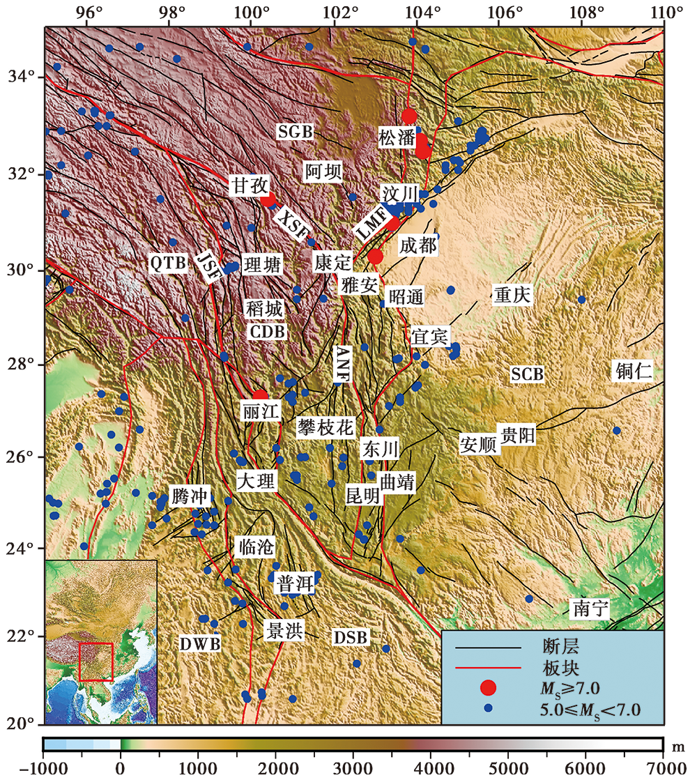
图 1 青藏高原东南缘的地质构造(1970—2020年) SGB 松潘-甘孜块体, SCB 华南块体, QTB 羌塘块体, CDB 川滇菱形块体, DWB 滇西块体, DSB 滇南块体, LMF 龙门山断裂, XSF 鲜水河断裂, ANF 安宁河断裂, JSF 金沙江断裂。地震数据来自中国地震台网中心
Fig. 1 Geological structures of the study area(1970—2020).
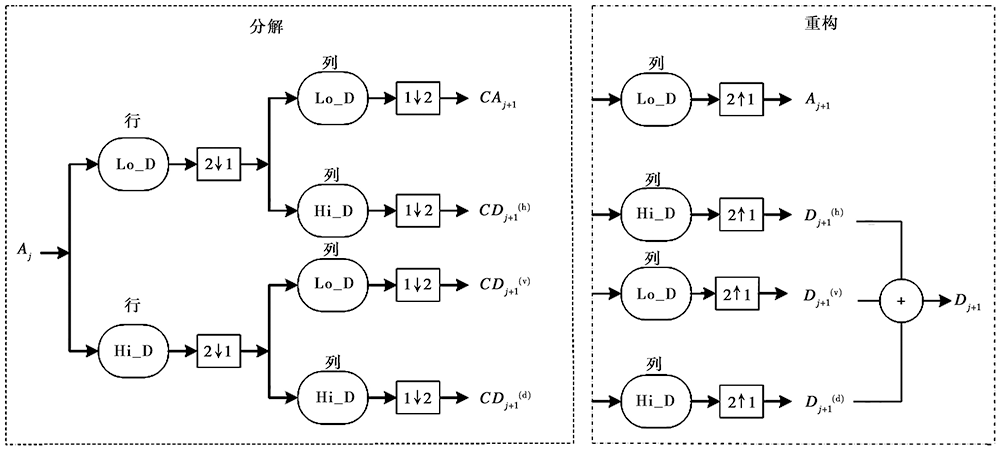
图 2 小波多尺度分解、 重构流程图
Fig. 2 Flow chart of wavelet multi-scale decomposition and reconstruction.
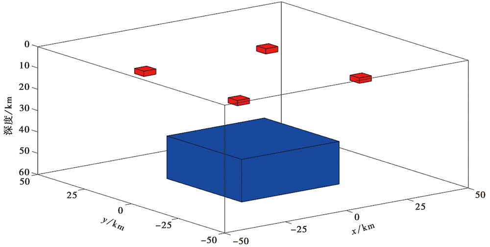
图 3 地质体试验模型
Fig. 3 Test model of geological masses.
| 模型 | 中心坐标/km | 尺寸大小/km | 剩余密度 /g·cm-3 | ||||
|---|---|---|---|---|---|---|---|
| X | Y | Z | 长 | 宽 | 高 | ||
| 棱柱1 | -25 | -25 | 10 | 5 | 5 | 2.5 | 0.4 |
| 棱柱2 | 25 | -25 | 10 | 5 | 5 | 2.5 | 0.4 |
| 棱柱3 | 25 | 25 | 10 | 5 | 5 | 2.5 | 0.4 |
| 棱柱4 | -25 | 25 | 10 | 5 | 5 | 2.5 | 0.4 |
| 棱柱5 | 0 | 0 | 50 | 40 | 40 | 20 | 0.6 |
表1 试验模型参数
Table1 Test model parameters
| 模型 | 中心坐标/km | 尺寸大小/km | 剩余密度 /g·cm-3 | ||||
|---|---|---|---|---|---|---|---|
| X | Y | Z | 长 | 宽 | 高 | ||
| 棱柱1 | -25 | -25 | 10 | 5 | 5 | 2.5 | 0.4 |
| 棱柱2 | 25 | -25 | 10 | 5 | 5 | 2.5 | 0.4 |
| 棱柱3 | 25 | 25 | 10 | 5 | 5 | 2.5 | 0.4 |
| 棱柱4 | -25 | 25 | 10 | 5 | 5 | 2.5 | 0.4 |
| 棱柱5 | 0 | 0 | 50 | 40 | 40 | 20 | 0.6 |
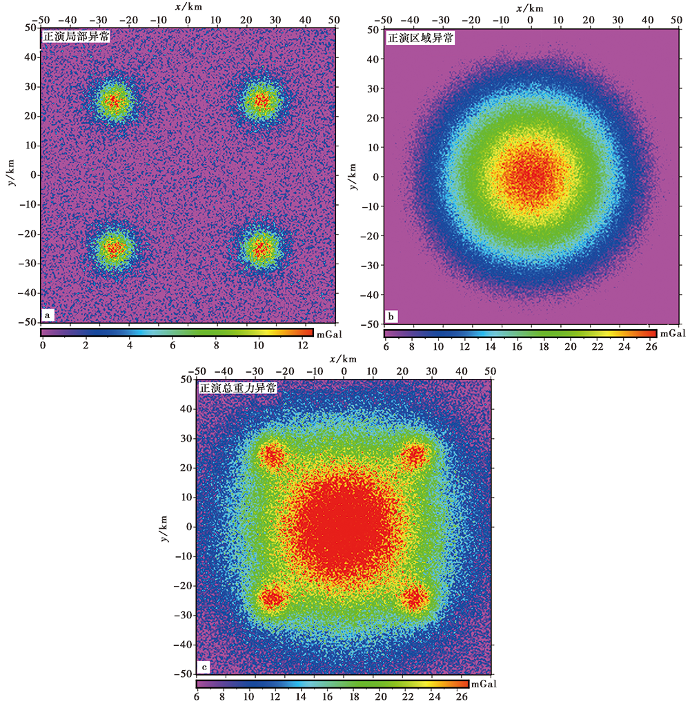
图 4 加入高斯随机噪声的试验模型正演重力异常
Fig. 4 The gravity anomalies of test model with Gaussian random noise.
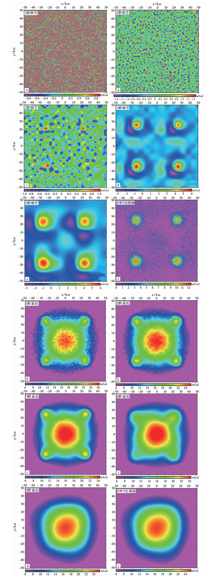
图 5 正演总重力异常多尺度分解结果
Fig. 5 Results of the forward total gravity anomaly by multi-scale decomposition.
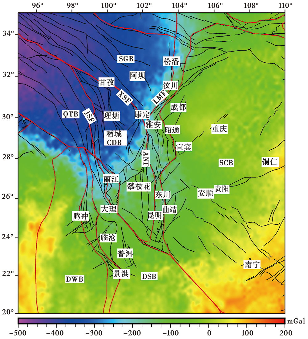
图 6 青藏高原东南缘布格重力异常
Fig. 6 Bouguer gravity anomaly in the study area.
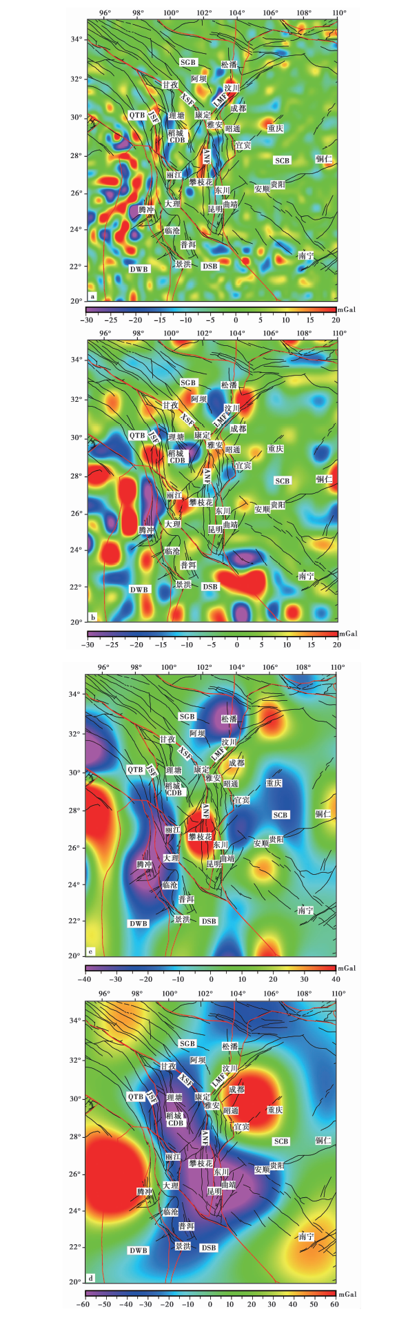
图 7 小波多尺度分解得到的2~5阶小波细节
Fig. 7 The 2nd to 5th order details by multi-scale wavelet decomposition.
| 阶次 | 近似场源深度/km | 备注 |
|---|---|---|
| 1 | 3.5 | 沉积层 |
| 2 | 12.6 | 上地壳 |
| 3 | 19.4 | 中上地壳 |
| 4 | 26.2 | 中下地壳 |
| 5 | 48.8 | 下地壳(平均莫霍面深度) |
表2 1~5阶小波细节近似场源深度
Table2 Approximated source depths of the 1~5 order details
| 阶次 | 近似场源深度/km | 备注 |
|---|---|---|
| 1 | 3.5 | 沉积层 |
| 2 | 12.6 | 上地壳 |
| 3 | 19.4 | 中上地壳 |
| 4 | 26.2 | 中下地壳 |
| 5 | 48.8 | 下地壳(平均莫霍面深度) |
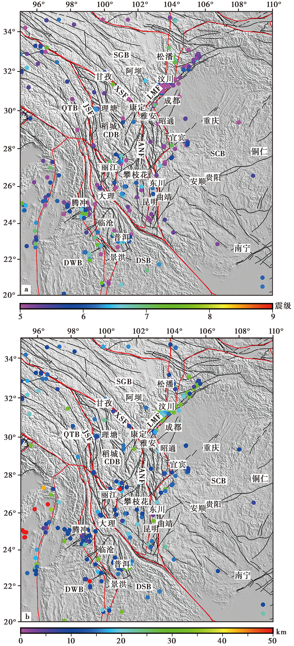
图 8 青藏高原东南缘地震震级(a)与震源深度(b)分布(1970—2020年) 地震数据来自中国地震台网中心
Fig. 8 Distribution of seismic magnitude(a)and depth(b)in the southeastern Qinghai-Tibet Plateau(1970—2020).
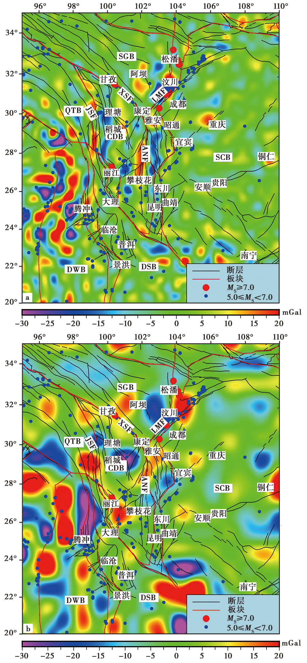
图 9 2、 3阶细节与5级以上地震震中位置的对比
Fig. 9 Comparison between the 2ndand 3rd order detail and the epicenter locations of the erathquakes over magnitude 5.
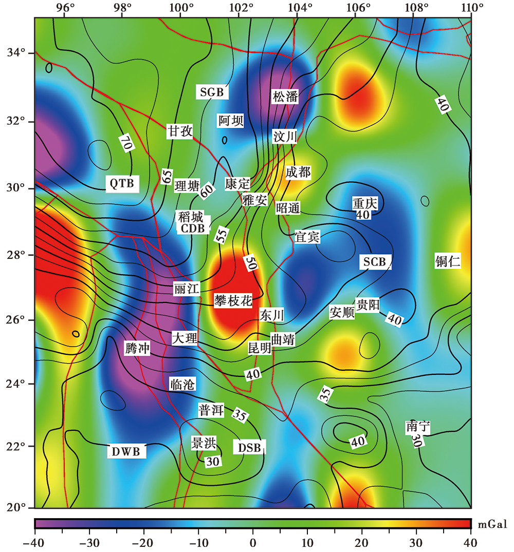
图 10 研究区域4阶细节与地壳厚度等值线(数据来源: CRUST1.0模型; 厚度单位: km)
Fig. 10 The 4th order detail and crustal thickness contours in the study area (data are from CRUST1.0 Model, unit: km).
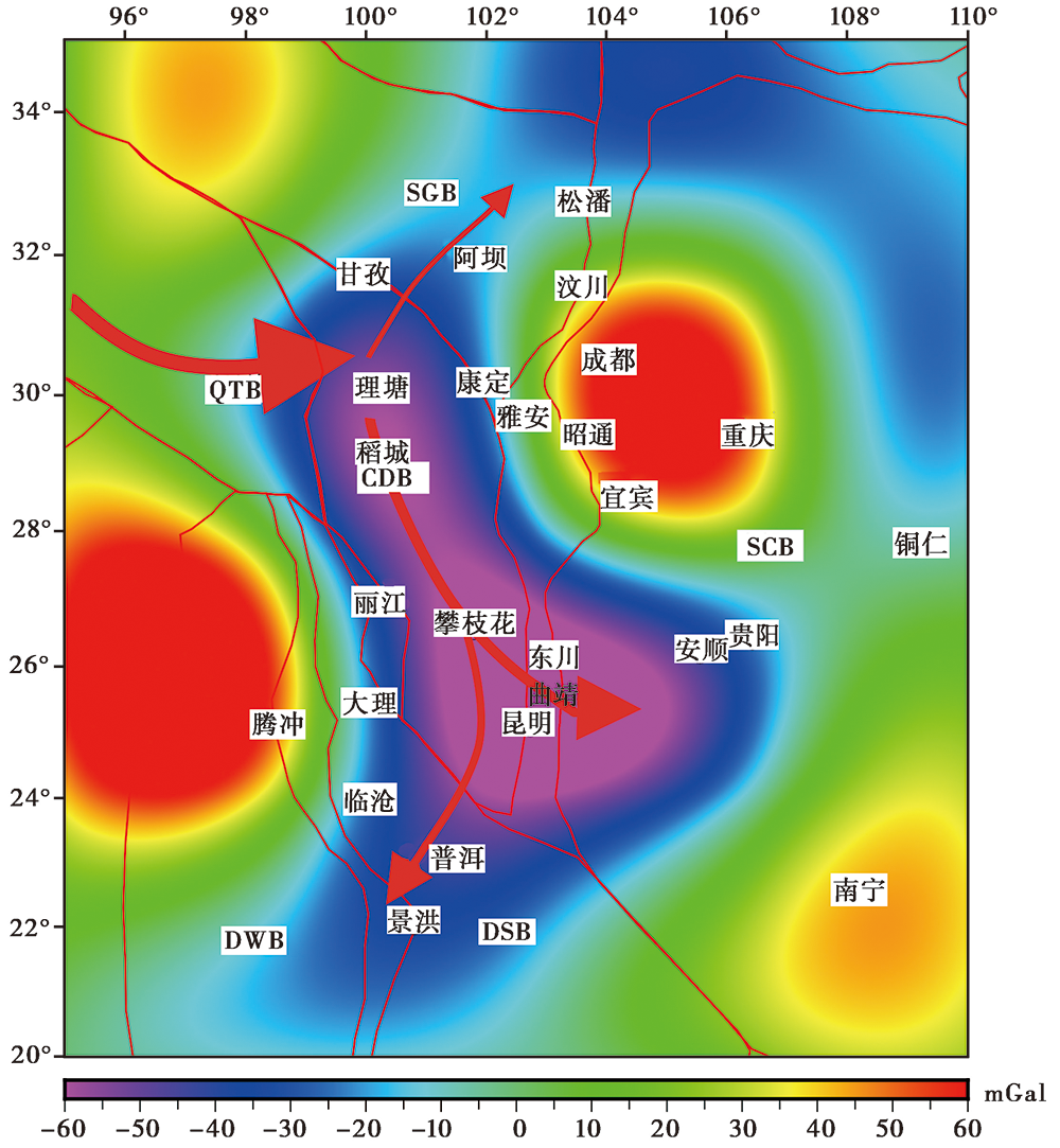
图 11 5阶小波细节反映的下地壳流流向(红色箭头)
Fig. 11 Flowing direction of the lower crustal flow showed in the 5th order detailed image(red arrow).
| [1] | 毕奔腾, 胡祥云, 李丽清, 等. 2016. 青藏高原东北部多尺度重力场及其地球动力学意义[J]. 地球物理学报, 59(2): 543-555. |
| BI Ben-teng, HU Xiang-yun, LI Li-qing, et al. 2016. Multi-scale analysis to the gravity field of the northeastern Tibetan plateau and its geodynamic implications[J]. Chinese Journal of Geophysics, 59(2): 543-555. (in Chinese) | |
| [2] | 邓起东, 程绍平, 马冀, 等. 2014. 青藏高原地震活动特征及当前地震活动形势[J]. 地球物理学报, 57(7): 2025-2042. |
| DENG Qi-dong, CHENG Shao-ping, MA Ji, et al. 2014. Seismic activities and earthquake potential in the Tibetan plateau[J]. Chinese Journal of Geophysics, 57(7): 2025-2042. (in Chinese) | |
| [3] | 邓起东, 张培震, 冉勇康, 等. 2003. 中国活动构造与地震活动[J]. 地学前缘, 10(S1): 66-73. |
| DENG Qi-dong, ZHANG Pei-zhen, RAN Yong-kang, et al. 2003. Active tectonics and earthquake avtivities in China[J]. Earth Science Frontiers, 10(S1): 66-73. (in Chinese) | |
| [4] | 刁博, 王家林, 程顺有. 2007. 重力异常小波多分辨分析分解阶次的确定[J]. 地球科学(中国地质大学学报), 32(4): 564-568. |
| DIAO Bo, WANG Jia-lin, CHENG Shun-you. 2007. The confirmation of decomposition level in wavelet multi-resolution analysis for gravity anomalies[J]. Earth Science(Journal of China University of Geosciences), 32(4): 564-568. (in Chinese) | |
| [5] | 侯遵泽, 杨文采. 1997. 中国重力异常的小波变换与多尺度分析[J]. 地球物理学报, 40(1): 85-95. |
| HOU Zun-ze, YANG Wen-cai. 1997. Wavelet transform and multi-scale analysis of gravity anomaly in China[J]. Chinese Journal of Geophysics, 40(1): 85-95. (in Chinese) | |
| [6] | 侯遵泽, 杨文采, 刘家琦. 1998. 中国大陆地壳密度差异多尺度反演[J]. 地球物理学报, 41(5): 642-651. |
| HOU Zun-ze, YANG Wen-cai, LIU Jia-qi. 1998. Multiscale inversion of the density contrast within the crust of China[J]. Chinese Journal of Geophysics, 41(5): 642-651. (in Chinese) | |
| [7] | 金胜, 魏文博, 汪硕, 等. 2010. 青藏高原地壳高导层的成因及动力学意义探讨: 大地电磁探测提供的证据[J]. 地球物理学报, 53(10): 2376-2385. |
| JIN Sheng, WEI Wen-bo, WANG Shuo, et al. 2010. Discussion of the formation and dynamic signification of the high conductive layer in Tibetan crust[J]. Chinese Journal of Geophysics, 53(10): 2376-2385. (in Chinese) | |
| [8] | 胡敏章, 金涛勇, 郝洪涛, 等. 2020. 青藏高原东南缘岩石圈有效弹性厚度及其构造意义[J]. 地球物理学报, 63(3): 969-987. |
| HU Min-zhang, JIN Tao-yong, HAO Hong-tao, et al. 2020. Lithospheric effective elastic thickness and its tectonics in the southeastern Qinghai-Tibet Plateau[J]. Chinese Journal of Geophysics, 63(3): 969-987. (in Chinese) | |
| [9] | 李德威. 2012. 东昆仑、 玉树、 汶川地震的发生规律和形成机理: 兼论大陆地震成因与预测[J]. 地学前缘, 17(5): 179-192. |
| LI De-wei. 2012. Occurrence and formation mechanism of the East Kunlun, Yushu and Wenchuan earthquakes: Concurrent discussion on the genesis and prediction of continental earthquakes[J]. Earth Science Frontier, 17(5): 179-192. (in Chinese) | |
| [10] | 李健, 周云轩, 许惠平. 2001. 重力场数据处理中小波母函数的选择[J]. 物探与化探, 25(6): 410-416. |
| LI Jian, ZHOU Yun-xuan, XU Hui-ping. 2001. The selection of wavelet generating functions in data-processing of gravity field[J]. Geophysical and Geochemcal Exploration, 25(6): 410-416. (in Chinese) | |
| [11] | 李雪垒, 胥颐, 汪晟. 2017. 腾冲火山区S波速度结构与岩浆活动特征[J]. 科学通报, 62(26): 3067-3077. |
| LI Xue-lei, XU Yi, WANG Sheng. 2017. Evidence of magma activity from S-wave velocity structure of the Tengchong volcanic area[J]. Chinese Science Bulletin, 62(26): 3067-3077. (in Chinese) | |
| [12] | 楼海, 王椿镛. 2005. 川滇地区重力异常的小波分解与解释[J]. 地震学报, 27(5): 515-523. |
| LOU Hai, WANG Chun-yong. 2005. Wavelet analysis and interpretation of gravity data in Sichuan-Yunnan region[J]. Acta Seismologica Sinica, 27(5): 515-523. (in Chinese) | |
| [13] | 潘素珍, 王夫运, 段永红, 等. 2015. 滇南及邻近地区基底结构: 镇康-泸西深地震测深剖面结果[J]. 地球物理学报, 58(11): 3917-3927. |
| PAN Su-zhen, WANG Fu-yun, DUAN Yong-hong, et al. 2015. Basement structure of southern Yunnan and adjacent areas: The Zhenkang-Luxi deep seismic sounding profile[J]. Chinese Journal of Geophysics, 58(11): 3917-3927. (in Chinese) | |
| [14] | 王椿镛, 韩渭宾, 吴建平, 等. 2003a. 松潘-甘孜造山带地壳速度结构[J]. 地震学报, 25(3): 229-241. |
| WANG Chun-yong, HAN Wei-bin, WU Jian-ping, et al. 2003a. Crustal structure beneath the Songpan-Garze orogenic belt[J]. Acta Seismologica Sinica, 25(3): 229-241. (in Chinese) | |
| [15] | 王椿镛, 楼海, 吴建平, 等. 2002. 腾冲火山地热区地壳结构的地震学研究[J]. 地震学报, 24(3): 231-242. |
| WANG Chun-yong, LOU Hai, WU Jian-ping, et al. 2002. Seismological study on the crustal structure of Tengchong volcanic-geothermal area[J]. Acta Seismologica Sinica, 24(3): 231-242. (in Chinese) | |
| [16] | 王椿镛, 吴建平, 楼海, 等. 2003b. 川西藏东地区的地壳P波速度结构[J]. 中国科学(D辑), 33(S1): 181-189. |
| WANG Chun-yong, WU Jian-ping, LOU Hai, et al. 2003b. Crustal P-wave velocity structure in eastern Sichuan and Tibet[J]. Science in China(Ser D), 33(S1): 181-189. (in Chinese) | |
| [17] | 王绪本, 余年, 高嵩, 等. 2017. 青藏高原东缘地壳上地幔电性结构研究进展[J]. 地球物理学报, 60(6): 2350-2370. |
| WANG Xu-ben, YU Nian, GAO Song, et al. 2017. Research progress in the electrical structure of the crust and upper mantle on the eastern margin of the Qinghai-Tibet Plateau[J]. Chinese Journal of Geophysics, 60(6): 2350-2370. (in Chinese) | |
| [18] |
解滔, 郑晓东, 康丽春, 等. 2015. 2013年4月20日芦山 MS7.0 地震前热红外亮温异常分析[J]. 地震地质, 37(1): 149-161. doi: 10.3969/j.issn.0253-4967.2015.01.012.
DOI |
| XIE Tao, ZHENG Xiao-dong, KANG Chun-li, et al. 2015. Possible thermal brightness temperature anomalies associated with Lushan(China)M7.0 earthquake on 20 April 2013 [J]. Seismology and Geology, 37(1): 149-161. (in Chinese) | |
| [19] | 玄松柏, 邢乐林, 谈洪波, 等. 2012. 中国大陆2000-2007年重力场变化多尺度分解[J]. 大地测量与地球动力学, 32(3): 7-16. |
| XUAN Song-bai, XING Yue-lin, TAN Hong-bo, et al. 2012. Wavelet multi-scale decomposition of gravity field variations during 2000-2007 in China mainland[J]. Journal of Geodesy and Geodynamics, 32(3): 7-16. (in Chinese) | |
| [20] | 杨文采, 侯遵泽, 于常青. 2015. 青藏高原地壳的三维密度结构和物质运动[J]. 地球物理学报, 58(11): 4223-4234. |
| YANG Wen-cai, HOU Zun-ze, YU Chang-qing. 2015. Three-dimensional density structure of the Tibetan plateau and crustal mass movement[J]. Chinese Journal of Geophysics, 58(11): 4223-4234. (in Chinese) | |
| [21] | 杨文采, 施志群, 侯遵泽, 等. 2001. 离散小波变换与重力异常多重分解[J]. 地球物理学报, 44(4): 99-106. |
| YANG Wen-cai, SHI Zhi-qun, HOU Zun-ze, et al. 2001. Discrete wavelet transform for multiple decomposition of gravity anomalies[J]. Chinese Journal of Geophysics, 44(4): 99-106. (in Chinese) | |
| [22] | 张龙, 胡毅力, 秦敏, 等. 2015. 云南腾冲火山区地壳及岩石圈厚度研究[J]. 地球物理学报, 58(5): 1622-1633. |
| ZHANG Long, HU Yi-li, QIN Min, et al. 2015. Study on crustal and lithosphere thicknesses of Tengchong volcanic area in Yunnan[J]. Chinese Journal of Geophysics, 58(5): 1622-1633. (in Chinese) | |
| [23] | 张培震, 邓起东, 张国民, 等. 2003. 中国大陆的强震活动与活动地块[J]. 中国科学(D辑), 33(S1): 12-20. |
| ZHANG Pei-zhen, DENG Qi-dong, ZHANG Guo-min, et al. 2003. Strong earthquake activity and active landmass in Mainland China[J]. Science in China(Ser D), 33(S1): 12-20. (in Chinese) | |
| [24] | 张培震, 邓起东, 张竹琪, 等. 2013. 中国大陆的活动断裂、 地震灾害及其动力过程[J]. 中国科学(D辑), 43(10): 1607-1620. |
| ZHANG Pei-zhen, DENG Qi-dong, ZHANG Zhu-qi, et al. 2013. Active faults, earthquake hazards and associated geodynamic processes in continental China[J]. Science in China(Ser D), 43(10): 1607-1620. (in Chinese) | |
| [25] | 张永谦, 王谦身, 滕吉文. 2010. 川西藏东地区的地壳均衡异常及其与地震分布的关系[J]. 地球物理学报, 53(11): 2631-2638. |
| ZHANG Yong-qian, WANG Qian-shen, TENG Ji-wen. 2010. Crustal equilibrium anomalies in eastern Sichuan and Tibet and their relationship with earthquake distribution[J]. Chinese Journal of Geophysics, 53(11): 2631-2638. (in Chinese) | |
| [26] |
Bai D, Unsworth M, Meju M A, et al. 2010. Crustal deformation of the eastern Tibetan plateau revealed by magnetotelluric imaging[J]. Nature Geoscience, 3(5): 358-362.
DOI URL |
| [27] |
Balmino G, Vales N, Bonvalot S, et al. 2012. Spherical harmonic modelling to ultra-high degree of Bouguer and isostatic anomalies[J]. Journal of Geodesy, 86(7): 499-520.
DOI URL |
| [28] |
Chung S, Lo C, Lee T Y, et al. 1998. Diachronous uplift of the Tibetan plateau starting 40Myr ago[J]. Nature, 394(6695): 769-773.
DOI URL |
| [29] |
Clark M K, Royden L H. 2000. Topographic ooze: Building the eastern margin of Tibet by lower crustal flow[J]. Geology, 28(8): 703-706.
DOI URL |
| [30] |
Dong H, Wei W B, Jin S, et al. 2016. Extensional extrusion: Insights into south-eastward expansion of Tibetan plateau from magnetotelluric array data[J]. Earth and Planetary Science Letters, 454:78-85.
DOI URL |
| [31] | Gan W, Zhang P, Shen Z, et al. 2007. Present-day crustal motion within the Tibetan plateau inferred from GPS measurements[J]. Journal of Geophysical Research: Solid Earth, 112(B8): B08416. |
| [32] |
Li T, Xiao X, Li G, et al. 1986. The crustal evolution and uplift mechanism of the Qinghai-Tibet plateau[J]. Tectonophysics, 127(3): 279-289.
DOI URL |
| [33] | Mallat S. 1988. Multiresolution representation and wavelets [D]. University of Pennsylvania, Philadelphia. |
| [34] |
Mallat S. 1989. Multifrequency channel decompositions of images and wavelet models[J]. IEEE Transactions on Acoustics Speech and Signal Processing, 37(12): 2091-2110.
DOI URL |
| [35] | Molnar P. 1988. A review of geophysical constraints on the deep structure of the Tibetan plateau, the Himalaya and the Karakoram, and their tectonic implications[J]. Philosophical Transactions of the Royal Society. Mathematical, Physical and Engineering Sciences, 326(1589): 33-88. |
| [36] |
Molnar P, England P, Martinod J, et al. 1993. Mantle dynamics, uplift of the Tibetan plateau and the Indian monsoon[J]. Reviews of Geophysics, 31(4): 357-396.
DOI URL |
| [37] |
Molnar P, Tapponnier P. 1975. Cenozoic tectonics of Asia: Effects of a continental collision: Features of recent continental tectonics in Asia can be interpreted as results of the India-Eurasia collision[J]. Science, 189(4201): 419-426.
PMID |
| [38] |
Mukhopadhyay B, Acharyya A, Dasgupta S, et al. 2009. Statistical analysis on yearly seismic moment release data to demarcate the source zone for an impending earthquake in the Himalaya[J]. Acta Geophysica, 57(2): 387-399.
DOI URL |
| [39] |
Royden L H, Burchfiel B C, King R W, et al. 1997. Surface deformation and lower crustal flow in eastern Tibet[J]. Science, 276(5313): 788-790.
PMID |
| [40] | Scholz C H. 1990. The mechanics of earthquakes and faulting [D]. Cambridge University, Kamblidge. |
| [41] |
Spector A, Grant F S. 1970. Statistical models for interpreting aeromagnetic data[J]. Geophysics, 35(2): 293-302.
DOI URL |
| [42] |
Tapponnier P, Peltzer G, Le Dain A Y, et al. 1982. Propagating extrusion tectonics in Asia: New insights from simple experiments with plasticine[J]. Geology, 10(12): 611-616.
DOI URL |
| [43] | Tian T, Zhang J, Jiang W, et al. 2020. Quantitative study of crustal structure spatial variation based on gravity anomalies in the eastern Tibetan plateau: Implication for earthquake susceptibility assessment[J]. Earth and Space Science, 7(3): 1-23. |
| [44] |
Unsworth M, Jones A G, Wei W, et al. 2005. Crustal rheology of the Himalaya and southern Tibet inferred from magnetotelluric data[J]. Nature, 438(7064): 78-81.
DOI URL |
| [45] |
Wu Y, Gao Y. 2019. Gravity pattern in southeast margin of Tibetan plateau and its implications to tectonics and large earthquakes[J]. Earth and Planetary Physics, 3(5): 425-434.
DOI URL |
| [46] |
Xu C, Liu Z, Luo Z, et al. 2017. Moho topography of the Tibetan plateau using multi-scale gravity analysis and its tectonic implications[J]. Journal of Asian Earth Sciences, 138:378-386.
DOI URL |
| [47] |
Xuan S, Shen C, Shen W, et al. 2018. Crustal structure of the southeastern Tibetan plateau from gravity data: New evidence for clockwise movement of the Chuan-Dian rhombic block[J]. Journal of Asian Earth Sciences, 159:98-108.
DOI URL |
| [48] |
Yao H, Beghein C, Der Hilst R D, et al. 2008. Surface wave array tomography in SE Tibet from ambient seismic noise and two-station analysis: Ⅱ. Crustal and upper-mantle structure[J]. Geophysical Journal International, 173(1): 205-219.
DOI URL |
| [49] |
Zhang P, Shen Z, Wang M, et al. 2004. Continuous deformation of the Tibetan plateau from global positioning system data[J]. Geology, 32(9): 809-812.
DOI URL |
| [50] | Zhao G, Wang L, Chen X, et al. 2010. The active fault belts in eastern Tibet margin inferred using magnetotellurics[J]. Geologica Acta, 8(1): 99-110. |
| [1] | 徐志萍, 张扬, 杨利普, 徐顺强, 姜磊, 唐淋, 林吉焱. 河南省及邻区主要活动断裂的深部构造特征[J]. 地震地质, 2022, 44(6): 1521-1538. |
| [2] | 王禹丹, 张景发, 田甜. 敦化-密山断裂带及周边地区的航磁特征与深部构造[J]. 地震地质, 2022, 44(2): 448-460. |
| [3] | 唐茂云, 刘静, 李翠平, 王伟, 张金玉, 许强. 青藏高原东南缘的新生代盆地古高度重建研究与进展[J]. 地震地质, 2021, 43(3): 576-599. |
| [4] | 孙翔宇, 詹艳, 赵凌强, 陈小斌, 李陈侠, 孙建宝, 韩静, 崔腾发. 东昆仑断裂带东端和2017年九寨沟7.0级地震区深部电性结构探测[J]. 地震地质, 2020, 42(1): 182-197. |
| [5] | 商咏梅, 杨彧, 杨晓松. 岩石圈主要各向异性矿物的CPO特征及其对岩石圈动力学研究的启示[J]. 地震地质, 2019, 41(3): 704-725. |
| [6] | 陈兆辉, 孟小红, 张双喜, 刘金钊, 王同庆, 张品, 韦少港. 青藏高原东南缘多尺度重力场变化特征及孕震机理分析[J]. 地震地质, 2019, 41(3): 690-703. |
| [7] | 王辉, 曹建玲, 徐化超. 中小地震震源机制解在青藏高原东南缘地区断层稳定性分析中的初步应用[J]. 地震地质, 2019, 41(3): 633-648. |
| [8] | 吴贵灵, 祝成宇, 王国灿, 张攀. 青藏高原东南缘地貌边界性质的界定及其对高原东南缘扩展模式的启示[J]. 地震地质, 2019, 41(2): 281-299. |
| [9] | 王虎, 冉勇康, 陈立春, 梁明剑, 高帅坡, 李彦宝, 徐良鑫. 安宁河断裂带南段滑动速率估计[J]. 地震地质, 2018, 40(5): 967-979. |
| [10] | 王鑫, 张景发, 姜文亮, 蒋洪波, 田甜, 高敏, 付萍杰. 郯庐断裂带南段重力异常及不同深度的横向构造特征[J]. 地震地质, 2016, 38(2): 370-385. |
| [11] | 罗佳宏, 马文涛. 三峡库区上地壳速度结构初步研究[J]. 地震地质, 2016, 38(2): 329-341. |
| [12] | 王鑫, 张景发, 付萍杰, 高敏. 沂沭断裂带重力场及地壳结构特征[J]. 地震地质, 2015, 37(3): 731-747. |
| [13] | 李永华, 徐小明, 张恩会, 高家乙. 青藏高原东南缘地壳结构及云南鲁甸、景谷地震深部孕震环境[J]. 地震地质, 2014, 36(4): 1204-1216. |
| [14] | 高云, 宋维琪, 刘仕友, 杨凯. 地震资料高阶累积量相关法砂体预测[J]. 地震地质, 2007, 29(1): 88-94. |
| [15] | 蒋靖祥, 尹光华, 温和平, 余建和. 库车坳陷的地震孕震环境初探[J]. 地震地质, 2002, 24(3): 346-354. |
| 阅读次数 | ||||||
|
全文 |
|
|||||
|
摘要 |
|
|||||
