地震地质 ›› 2022, Vol. 44 ›› Issue (3): 625-648.DOI: 10.3969/j.issn.0253-4967.2022.03.005
李梦圆1)( ), 蒋海昆2),*(), 宋金2), 王锦红1)
收稿日期:2021-05-06
修回日期:2021-07-10
出版日期:2022-06-20
发布日期:2022-08-02
通讯作者:
蒋海昆
作者简介:李梦圆, 女, 1995年生, 2021年于中国地震局地震预测研究所获固体地球物理专业硕士学位, 助理工程师, 主要研究方向为地震活动及相关影响因素研究, E-mail: 2994020855@qq.com。
基金资助:
LI Meng-yuan1)(), JIANG Hai-kun2),*(), SONG Jin2), WANG Jin-hong1)
Received:2021-05-06
Revised:2021-07-10
Online:2022-06-20
Published:2022-08-02
Contact:
JIANG Hai-kun
摘要:
2020年7—8月西藏波密易贡乡发生ML4.9显著震群, 1个月内共发生25次ML≥4.0地震, 引起了广泛关注。1970年以来的资料显示, 波密震群区域的地震活动时间基本集中于每年的7、 8月, 空间上主要分布于15km×20km的区域范围内, 最大震级基本稳定在ML4.5~5.0之间, 年均释放的地震能量大体相当于1次ML4.9地震。波密震群区域的地震活动与上半年降水规模及降水过程关系密切, 震群活动发生于降水量的峰值时段, 一般起始于当年首次较显著降水过程结束之后。地震活动水平与规模以上降水开始时间的早晚、 上半年规模以上降水的天数及4—6月降水量增加速率等反映降水规模和降水过程的因素呈正相关。波密震群区域的地震活动主要集中分布于近NE向勒曲藏布中段及两侧分支流域, 该区夏季成为周边水体快速汇聚的区域, 这为每年7、 8月流体触发地震活动提供了基本条件; 地震密集分布区域地表出露的岩石以石英砂岩、 粉砂岩为主, 相对而言具有更高的渗透率, 便于流体下渗引起地下介质孔隙压力增加; 地震密集区域被多条断层所围限, 断层一方面对地表聚集水体下渗扩散的区域具有一定围限作用, 另一方面又具有较好的流体导通性, 便于流体快速下渗, 其中张性断层更是如此。在流体自重及地表水体载荷压力的共同作用下, 流体沿断裂破碎带及具有较好渗透性的砂岩类岩石介质快速下渗, 导致地下断层、 裂隙及孔隙介质中的孔隙压力快速增大, 断层、 裂隙强度随之降低, 进而导致地震活动。不同深度处的孔隙压力随时间变化的模拟计算结果支持上述关于波密震群区域地震活动的机理解释。
中图分类号:
李梦圆, 蒋海昆, 宋金, 王锦红. 西藏波密的地震活动及季节性降雨的触发作用[J]. 地震地质, 2022, 44(3): 625-648.
LI Meng-yuan, JIANG Hai-kun, SONG Jin, WANG Jin-hong. SEISMICITY TRIGGERED BY SEASONAL RAINFALL: A CASE STUDY IN BOMI, TIBET[J]. SEISMOLOGY AND GEOLOGY, 2022, 44(3): 625-648.
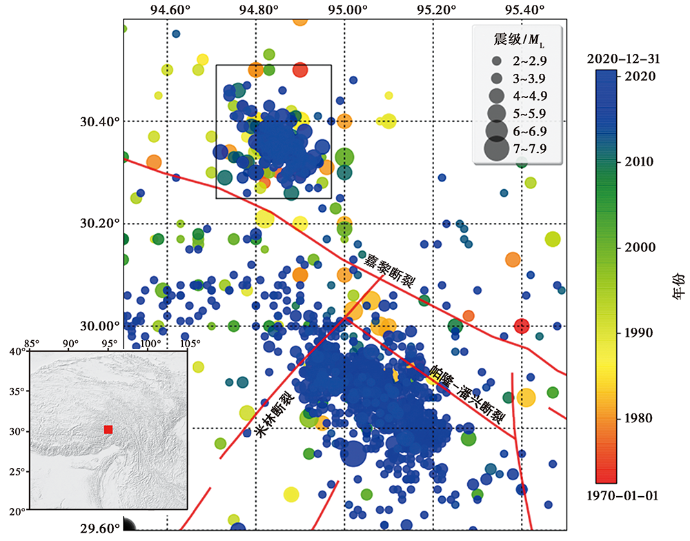
图 1 波密震群(图中方框所示)附近区域的主要断层及1970—2020年ML≥2.0地震的分布 图中方框为30.25°~30.50°N, 94.70°~94.95°E
Fig. 1 The distribution of earthquakes with ML≥2.0 in 1970—2020 and the major faults in the surrounding area of Bomi swarm.
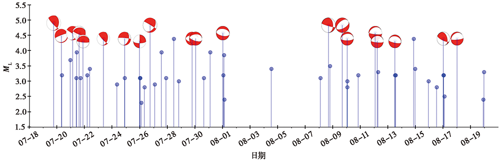
图 2 2020年波密震群ML≥2.0地震的M-t图及部分地震的震源机制解
Fig. 2 M-t diagram of the 2020 Bomi earthquake swarm with ML≥2.0 and focal mechanism solutions of some earthquakes.
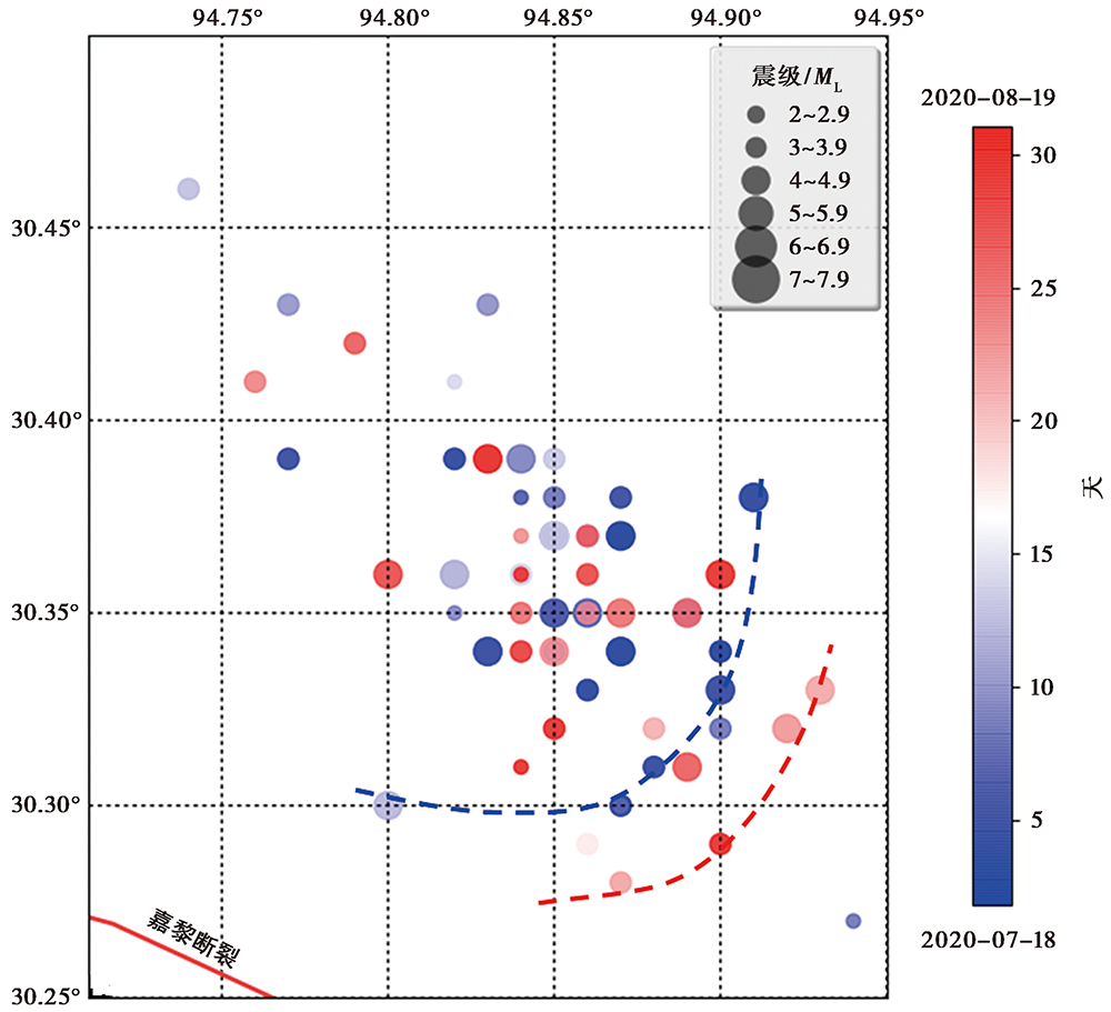
图 3 2020年波密震群ML≥2.0地震的空间分布(2020年7月18日—8月19日)
Fig. 3 Earthquake distribution of the 2020 Bomi swarm with ML≥2.0(from July 18 to August 19, 2020).
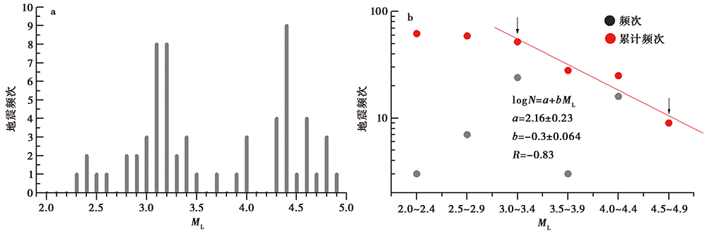
图 4 2020年波密震群(2020年7月18日—8月19日)的频次-震级统计(a)及G-R关系(b)
Fig. 4 Frequency-magnitude statistics(a)and G-R relationship(b) of the 2020 Bomi swarm(from July 18 to August 19, 2020).
| 序 号 | 月-日 | 时:分:秒 (BTC) | 北纬 /(°) | 东经 /(°) | ML | 深度 /km (CENC) | 深度 /km (CAP) | 节面Ⅰ | 节面Ⅱ | ||||
|---|---|---|---|---|---|---|---|---|---|---|---|---|---|
| φs | δ | λ | φs | δ | λ | ||||||||
| 0 | 07-19 | 18:15:45 | 30.37 | 94.87 | 4.9 | 8 | 3 | 135° | 75° | 70° | 10° | 25° | 142° |
| 1 | 07-20 | 07:36:36 | 30.34 | 94.87 | 4.5 | 8 | 4 | 250° | 80° | -87° | 55° | 10° | -105° |
| 2 | 07-21 | 03:21:36 | 30.38 | 94.91 | 4.6 | 9 | 3 | 120° | 85° | 60° | 21° | 30° | 170° |
| 07-21 | 10:15:18 | 30.30 | 94.87 | 4.0 | 8 | ||||||||
| 3 | 07-21 | 14:18:46 | 30.34 | 94.83 | 4.6 | 7 | 2 | 112° | 74° | 102° | 255° | 20° | 55° |
| 4 | 07-21 | 21:26:14 | 30.33 | 94.90 | 4.3 | 10 | 0 | 95° | 76° | 94° | 260° | 15° | 75° |
| 5 | 07-23 | 08:47:42 | 30.35 | 94.85 | 4.4 | 10 | 3 | 135° | 75° | 65° | 16° | 29° | 148° |
| 6 | 07-24 | 21:34:22 | 30.35 | 94.86 | 4.4 | 7 | 3 | 275° | 80° | -60° | 22° | 31° | 161° |
| 7 | 07-25 | 23:58:34 | 30.37 | 94.85 | 4.3 | 8 | 0° | 90° | -25° | 90° | 55° | -180° | |
| 8 | 07-26 | 17:58:55 | 30.39 | 94.84 | 4.8 | 8 | 3 | 300° | 85° | -60° | 39° | 30° | -170° |
| 07-27 | 13:50:18 | 30.43 | 94.83 | 4.0 | 10 | ||||||||
| 07-28 | 11:32:27 | 30.35 | 94.89 | 4.4 | 10 | ||||||||
| 9 | 07-29 | 19:07:10 | 30.36 | 94.82 | 4.4 | 9 | 5 | 268° | 45° | -95° | 95° | 45° | -85° |
| 10 | 07-30 | 01:27:51 | 30.30 | 94.80 | 4.4 | 8 | 5 | 105° | 60° | -80° | 266° | 31° | -107° |
| 07-31 | 02:38:36 | 30.39 | 94.85 | 4.0 | 9 | ||||||||
| 11 | 08-01 | 00:45:07 | 30.37 | 94.86 | 4.6 | 6 | 5 | 101° | 55° | -87° | 275° | 35° | -95° |
| 12 | 08-08 | 16:43:58 | 30.33 | 94.93 | 4.8 | 7 | 3 | 105° | 80° | 60° | 358° | 31° | 161° |
| 13 | 08-09 | 16:50:11 | 30.32 | 94.92 | 4.8 | 10 | 5 | 65° | 50° | -80° | 230° | 41° | -102° |
| 14 | 08-10 | 01:13:30 | 30.34 | 94.85 | 4.4 | 7 | 4 | 90° | 65° | -85° | 258° | 25° | -101° |
| 15 | 08-12 | 02:14:14 | 30.35 | 94.87 | 4.6 | 10 | 4 | 95° | 75° | -80° | 241° | 18° | -123° |
| 16 | 08-12 | 05:27:26 | 30.35 | 94.89 | 4.3 | 10 | 4 | 95° | 75° | -85° | 256° | 16° | -108° |
| 17 | 08-13 | 12:27:57 | 30.31 | 94.89 | 4.3 | 10 | 4 | 100° | 70° | -90° | 280° | 20° | -90° |
| 08-14 | 20:58:38 | 30.36 | 94.80 | 4.4 | 8 | ||||||||
| 18 | 08-17 | 00:40:38 | 30.36 | 94.90 | 4.4 | 10 | 3 | 115° | 65° | 65° | 243° | 35° | 132° |
| 19 | 08-18 | 00:31:51 | 30.39 | 94.83 | 4.4 | 9 | 4 | 85° | 75° | -80° | 231° | 18° | -123° |
表 1 2020年波密震群ML≥4.0地震及震源机制(据中国地震台网中心预警速报部)
Table 1 The focal mechanism solutions of the 2020 Bomi swarm(ML≥4.0)
| 序 号 | 月-日 | 时:分:秒 (BTC) | 北纬 /(°) | 东经 /(°) | ML | 深度 /km (CENC) | 深度 /km (CAP) | 节面Ⅰ | 节面Ⅱ | ||||
|---|---|---|---|---|---|---|---|---|---|---|---|---|---|
| φs | δ | λ | φs | δ | λ | ||||||||
| 0 | 07-19 | 18:15:45 | 30.37 | 94.87 | 4.9 | 8 | 3 | 135° | 75° | 70° | 10° | 25° | 142° |
| 1 | 07-20 | 07:36:36 | 30.34 | 94.87 | 4.5 | 8 | 4 | 250° | 80° | -87° | 55° | 10° | -105° |
| 2 | 07-21 | 03:21:36 | 30.38 | 94.91 | 4.6 | 9 | 3 | 120° | 85° | 60° | 21° | 30° | 170° |
| 07-21 | 10:15:18 | 30.30 | 94.87 | 4.0 | 8 | ||||||||
| 3 | 07-21 | 14:18:46 | 30.34 | 94.83 | 4.6 | 7 | 2 | 112° | 74° | 102° | 255° | 20° | 55° |
| 4 | 07-21 | 21:26:14 | 30.33 | 94.90 | 4.3 | 10 | 0 | 95° | 76° | 94° | 260° | 15° | 75° |
| 5 | 07-23 | 08:47:42 | 30.35 | 94.85 | 4.4 | 10 | 3 | 135° | 75° | 65° | 16° | 29° | 148° |
| 6 | 07-24 | 21:34:22 | 30.35 | 94.86 | 4.4 | 7 | 3 | 275° | 80° | -60° | 22° | 31° | 161° |
| 7 | 07-25 | 23:58:34 | 30.37 | 94.85 | 4.3 | 8 | 0° | 90° | -25° | 90° | 55° | -180° | |
| 8 | 07-26 | 17:58:55 | 30.39 | 94.84 | 4.8 | 8 | 3 | 300° | 85° | -60° | 39° | 30° | -170° |
| 07-27 | 13:50:18 | 30.43 | 94.83 | 4.0 | 10 | ||||||||
| 07-28 | 11:32:27 | 30.35 | 94.89 | 4.4 | 10 | ||||||||
| 9 | 07-29 | 19:07:10 | 30.36 | 94.82 | 4.4 | 9 | 5 | 268° | 45° | -95° | 95° | 45° | -85° |
| 10 | 07-30 | 01:27:51 | 30.30 | 94.80 | 4.4 | 8 | 5 | 105° | 60° | -80° | 266° | 31° | -107° |
| 07-31 | 02:38:36 | 30.39 | 94.85 | 4.0 | 9 | ||||||||
| 11 | 08-01 | 00:45:07 | 30.37 | 94.86 | 4.6 | 6 | 5 | 101° | 55° | -87° | 275° | 35° | -95° |
| 12 | 08-08 | 16:43:58 | 30.33 | 94.93 | 4.8 | 7 | 3 | 105° | 80° | 60° | 358° | 31° | 161° |
| 13 | 08-09 | 16:50:11 | 30.32 | 94.92 | 4.8 | 10 | 5 | 65° | 50° | -80° | 230° | 41° | -102° |
| 14 | 08-10 | 01:13:30 | 30.34 | 94.85 | 4.4 | 7 | 4 | 90° | 65° | -85° | 258° | 25° | -101° |
| 15 | 08-12 | 02:14:14 | 30.35 | 94.87 | 4.6 | 10 | 4 | 95° | 75° | -80° | 241° | 18° | -123° |
| 16 | 08-12 | 05:27:26 | 30.35 | 94.89 | 4.3 | 10 | 4 | 95° | 75° | -85° | 256° | 16° | -108° |
| 17 | 08-13 | 12:27:57 | 30.31 | 94.89 | 4.3 | 10 | 4 | 100° | 70° | -90° | 280° | 20° | -90° |
| 08-14 | 20:58:38 | 30.36 | 94.80 | 4.4 | 8 | ||||||||
| 18 | 08-17 | 00:40:38 | 30.36 | 94.90 | 4.4 | 10 | 3 | 115° | 65° | 65° | 243° | 35° | 132° |
| 19 | 08-18 | 00:31:51 | 30.39 | 94.83 | 4.4 | 9 | 4 | 85° | 75° | -80° | 231° | 18° | -123° |
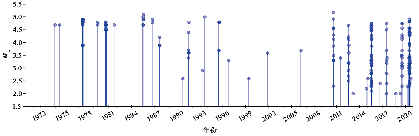
图 5 波密震群区域1970年以来ML≥2.0地震的M-t图
Fig. 5 M-t diagram of earthquake with ML≥2.0 in Bomi swarm region since 1970.
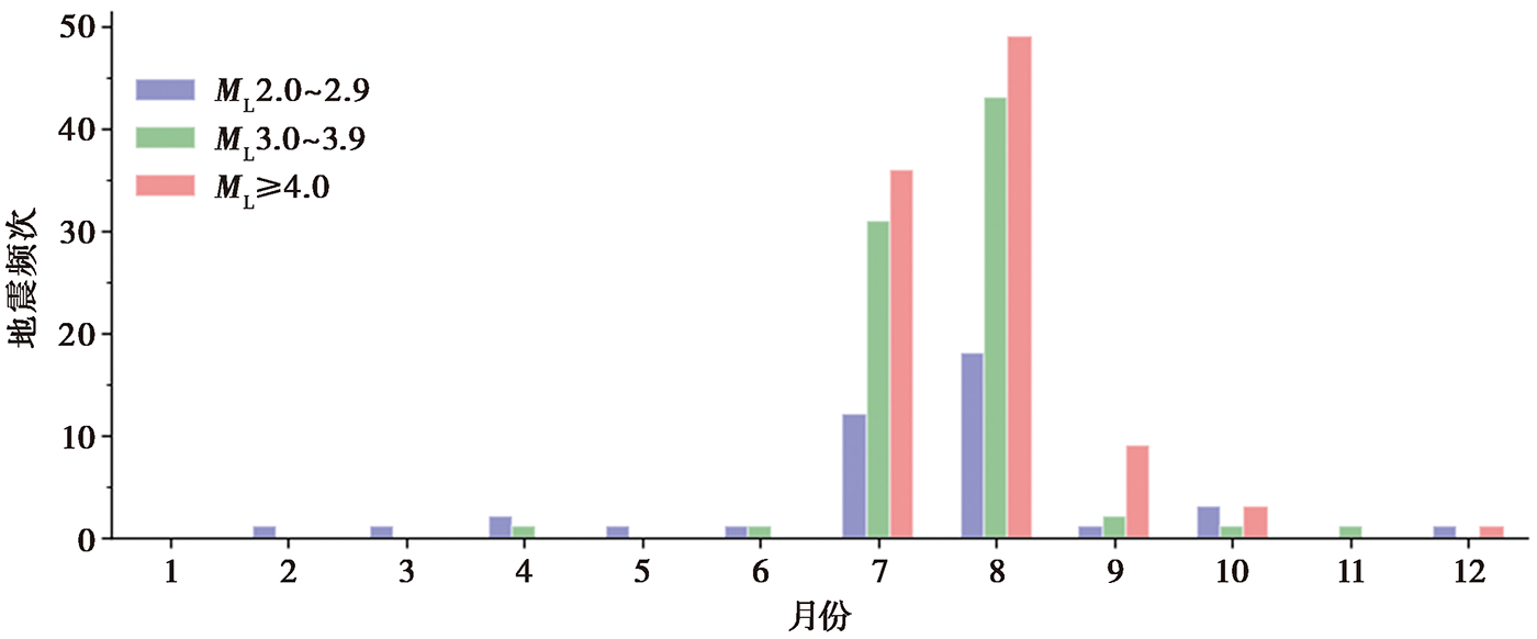
图 6 1970年以来波密震群区域按月统计的地震频次
Fig. 6 Monthly earthquake frequency in Bomi swarm region since 1970.
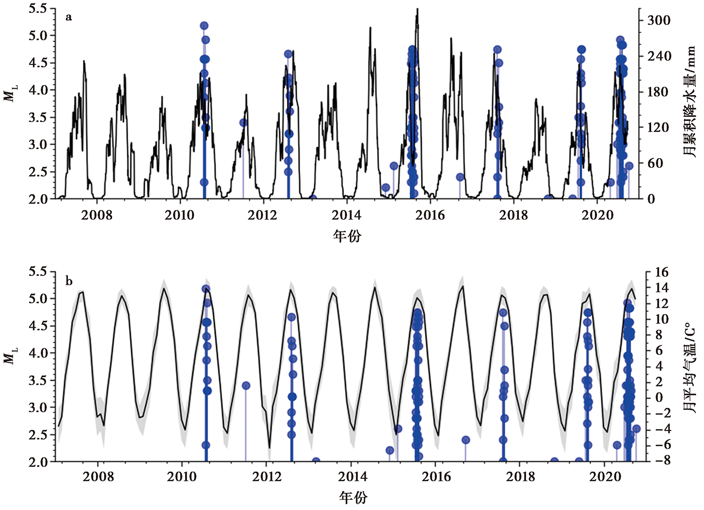
图 7 藏东南站30日累计、 1日滑动的降水量(a)、 气温(b)曲线及波密震群区域ML≥2.0地震的M-t图(蓝色)
Fig. 7 Moving averages with 30 days window and 1 day step for precipitation(a), monthly mean temperature(b) and the M-t diagram of earthquakes with ML≥2.0 in Bomi swarm region(blue).
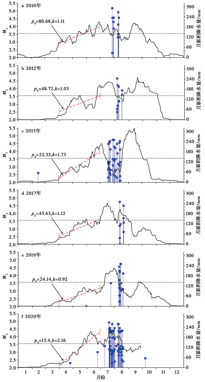
图 8 2007年以来有震年份的月降水量变化(黑)及波密震群区域ML≥2.0地震的M-t图(蓝) 月降水量为30日累计、 1日滑动计算结果; 水平虚线为2007—2020年月降水量均值+1倍标准差, 约为142mm
Fig. 8 Variations of monthly precipitation in years with earthquake activity since 2007(black) and the M-t diagram of earthquakes with ML≥2.0 in Bomi swarm region(blue).
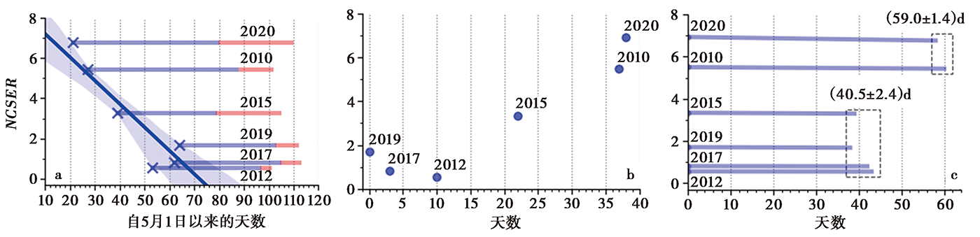
图 9 有震年的NCSER与规模以上降水开始的时间(a)、 上半年规模以上降水的天数(b)和规模以上降水开始至首次ML≥4.0地震之间时间间隔(c)之间的关系 “×”为规模以上降水开始时间; 阴影为85%置信概率条件下的拟合偏差范围; 蓝色水平线为规模以上降水开始至首次ML≥4.0地震之间的时间间隔, 红色水平线为ML≥4.0地震活动的持续时间
Fig. 9 The relationships between NCSER in years with earthquake activity and the starting time of precipitation above designated scale(a), the days of precipitation above designated scale in the first half year(b), and the time interval from the starting time of precipitation above designated scale to the first earthquake with ML≥4.0(c).
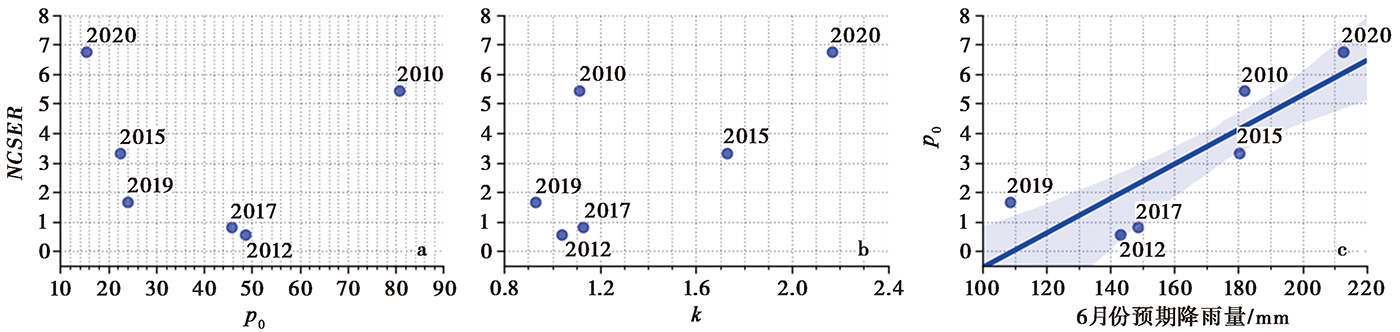
图 10 NCSER与3月累计降水量p0(a)、 4—6月降水量平均增加速率k(b)和6月预期降水量p(c)之间的关系 p=p0+kΔt, Δt=91, 为4月1日—6月30日之间的天数
Fig. 10 The relationships between NCSER in years with earthquake activity and the cumulative precipitation in March p0(a), the average increasing rate k of precipitation from April to June(b), and the expected precipitation p in June(c).
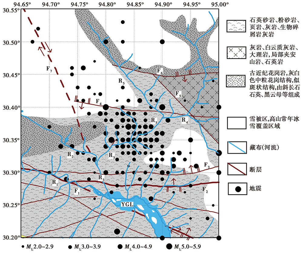
图 11 波密震群区域及附近断裂构造、 地表岩性、 水系及1970年以来ML≥2.0地震的分布 底图为1︰50万地质图, 其中断层F2、 F3、 F4和F7的相关信息来自1︰25万地质图①(①西藏自治区地质调查院,2005年,中华人民共和国地质图(H46CO0204),边坝县幅,1 :25万。)。棕色线条为断层, 断层的性质标注于图中(未标注者为性质不明)。粗线条为证据明确的活动断裂; 高山常年被冰雪覆盖区域的断层为推测结果, 用间断线表示。F1嘉黎-易贡藏布断裂, 右旋走滑; F2宗本-泽普断裂, N倾逆断; F3未命名断层, N倾正断; F4未命名断层, S倾逆断; F5未命名断层, 性质不明; F6隆格尔-纳木错-仲沙断裂, S倾逆断; F7色拉贡巴-汤木拉断裂, 右旋走滑。R1易贡藏布; R2道格藏布; R3勒曲藏布; R4那果龙藏布; R5若果藏布; YGL易贡湖
Fig. 11 Regional fault structures, lithology, river systems and distribution of earthquakes with ML≥2.0 since 1970 in Bomi swarm region and surrounding area.
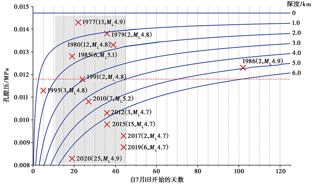
图 12 地下不同深度处孔隙压力随时间的变化(蓝色曲线) 红色水平点线指示孔隙压力p=0.011 8MPa, 通过不同深度孔隙压力曲线与红色水平点线相交的位置, 可粗略确定该深度处p≥0.011 8MPa的起始时间; “×”号为1970年以来有震群活动的年份中ML≥4.0地震开始的时间, 从上到下依时间顺序排列, 地震年份写于其后, 括号内为该震群ML≥4.0地震的频次及最大震级
Fig. 12 Variations of pore pressures at different depths with the time(blue curve).
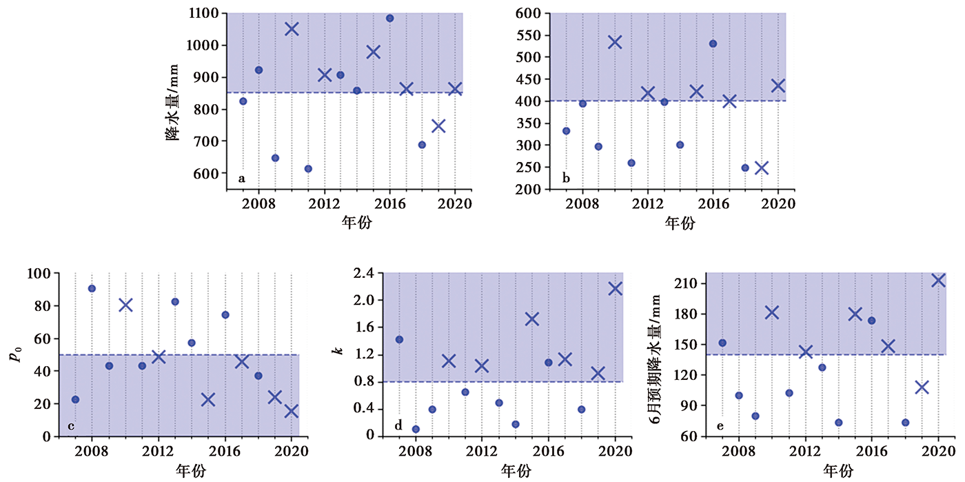
图 13 有震、 无震年份的降水量特征对比 a 年累计降水量; b 上半年累计降水量; c 4—6月月降水量变化p=p0+kΔt线性拟合参数p0值; d k值; e 6月预期降水量p值。 “×”号为有震年, 圆点为无震年。6月预期降水量p由p=p0+kΔt计算得到; Δt=91, 为4月1日—6月30日的天数
Fig. 13 Comparison on characteristics of precipitation in years with and without earthquake activities.
| [1] | 白玲, 李国辉, 宋博文. 2017. 2017年西藏米林6.9级地震震源参数及其构造意义[J]. 地球物理学报, 60(12): 4956—4963. |
| BAI Ling, LI Guo-hui, SONG Bo-wen. 2017. The source parameters of M6.9 Mainling, Tibet earthquake and its tectonic implications[J]. Chinese Journal of Geophysics, 60(12): 4956—4963 (in Chinese). | |
| [2] | 陈颙, 黄庭芳, 刘恩儒. 2009. 岩石物理学[M]. 合肥: 中国科学技术大学出版社. |
| CHEN Yong, HUANG Ting-fang, LIU En-ru. 2009. Rock Physics[M]. University of Science and Technology of China Press, Hefei (in Chinese). | |
| [3] | 刁守中, 蒋海昆, 徐学炎. 1990. 山东胜利油田角07井注水地震序列的演化及其机制[J]. 地震学报, 12(4): 399—406. |
| DIAO Shou-zhong, JIANG Hai-kun, XU Xue-yan. 1990. The evolution and mechanism of earthquake sequences induced by water injection in Jiao 7 Oil Well of Shengli Oil Field, Shandong Province[J]. Acta Seismologica Sinica, 12(4): 399—406 (in Chinese). | |
| [4] | 韩佳东, 杨建思, 刘莎, 等. 2019. 2017米林M6.9地震序列监测及南迦巴瓦地震活动性研究[J]. 地球物理学报, 62(6): 2059—2069. |
| HAN Jia-dong, YANG Jian-si, LIU Sha, et al. 2019. The 2017 Mainling M6.9 earthquake sequences monitoring and Namche Barwa seismicity analysis[J]. Chinese Journal of Geophysics, 62(6): 2059—2069 (in Chinese). | |
| [5] | 冀琴, 杨太保, 李霞. 2014. 念青唐古拉山东段八盖乡地区近40年冰川与气候变化研究[J]. 水土保持研究, 21(2): 306—310. |
| JI Qin, YANG Tai-bao, LI Xia. 2014. Study on relationship between glacier retreat and climate change in the eastern Nyainqentanglha in the past 40 years[J]. Research of Soil and Water Conservation, 21(2): 306—310 (in Chinese). | |
| [6] | 蒋海昆, 杨马陵, 孙学军, 等. 2011. 暴雨触发局部地震活动的一个典型例子: 2010年6月广西凌云-凤山交界3级震群活动[J]. 地球物理学报, 54(10): 2606—2619. |
| JIANG Hai-kun, YANG Ma-ling, SUN Xue-jun, et al. 2011. A typical example of locally triggered seismicity in the boundary area of Lingyun and Fengshan following the large rainfall event of June 2010[J]. Chinese Journal of Geophysics, 54(10): 2606—2619 (in Chinese). | |
| [7] | 李鸿儒, 白玲, 詹慧丽. 2021. 嘉黎断裂带活动性研究进展[J]. 地球与行星物理论评, 52(2): 182—193. |
| LI Hong-ru, BAI Lin, ZHAN Hui-li. 2021. Research progress of Jiali fault activity[J]. Reviews of Geophysics and Planetary Physics, 52(2): 182—193 (in Chinese). | |
| [8] | 任金卫, 单新建, 沈军, 等. 2001. 西藏易贡崩塌-滑坡-泥石流的地质地貌与运动学特征[J]. 地质论评, 47(6): 642—647. |
| REN Jin-wei, SHAN Xin-jian, SHEN Jun, et al. 2001. Geological characteristics and kinematies of the rock fall-landsilde in Yi’ong, southeastern Tibet[J]. Geological Review, 47(6): 642—647 (in Chinese). | |
| [9] | 沈大军, 陈传友. 1996. 青藏高原水资源及其开发利用[J]. 自然资源学报, 11(1): 8—14. |
| SHEN Da-jun, CHEN Chuan-you. 1996. Water resources of the Qing Hai-Xizang plateau and its exploitation[J]. Journal of Natural Resources, 11(1): 8—14 (in Chinese). | |
| [10] | 宋键, 唐方头, 邓志辉, 等. 2011. 喜马拉雅东构造结周边地区主要断裂现今运动特征与数值模拟研究[J]. 地球物理学报, 54(6): 1536—1548. |
| SONG Jian, TANG Fang-tou, DENG Zhi-hui, et al. 2011. Study on the characteristics and numerical simulation of the current movement of main faults in the area around the eastern Himalayan tectonic junction[J]. Chinese Journal of Geophysics, 54(6): 1536—1548 (in Chinese). | |
| [11] | 王晨旭, 熊永良, 张鲁鹏, 等. 2020. 尼泊尔地区季节性水文负荷对地震活动性的调制作用[J]. 大地测量与地球动力学, 40(6): 596—600. |
| WANG Chen-xu, XIONG Yong-liang, ZHANG Lu-peng, et al. 2020. Modulation of seismic activity by seasonal hydrological load in Nepal[J]. Journal of Geodesy and Geodynamics, 40(6): 596—600 (in Chinese). | |
| [12] | 王大纯, 张人权, 史毅宏等(编著). 1995. 水文地质学基础[M]. 北京: 地质出版社: 129. |
| WANG Da-chun, ZHANG Ren-quan, SHI Yi-hong, et al(eds). 1995. Fundamentals of Hydrogeology [M]. Geological Publishing House, Beijing: 129(in Chinese). | |
| [13] | 王志伟. 2020. 流体对断层带地震活动性的影响: 川滇地区若干实例研究[D]. 北京: 中国地震局地质研究所: 32. |
| WANG Zhi-wei. 2020. The influence of fluid on the seismicity of fault zones: Some case studies in Sichuan-Yunnan region[D]. Institute of Geology, China Earthquake Administration, Beijing: 32 (in Chinese). | |
| [14] | 杨锡金. 1985. 西藏南部山区河流的冰雪融水补给作用[J]. 冰川冻土, 7(3): 233—238. |
| YANG Xi-jin. 1985. The role of meltwater supply to the rivers in some mountains of south Tibet[J]. Journal of Glaciology and Geocryology, 7(3): 233—238 (in Chinese). | |
| [15] | 张捷, 况文欢, 张雄, 等. 2021. 全球油气开采诱发地震的研究现状与对策[J]. 地球与行星物理论评, 52(3): 239—265. |
| ZHANG Jie, KUANG Wen-huan, ZHANG Xiong, et al. 2021. Global review of induced earthquakes in oil and gas production fields[J]. Reviews of Geophysics and Planetary Physics, 52(3): 239—265 (in Chinese). | |
| [16] | Aki K, Fehler M, Aamodt R L, et al. 1982. Interpretation of seismic data from hydraulic fracturing experiments at the Fenton-hill, New-Mexico, hot dry rock geothermal site[J]. Journal of Geophysical Research: Solid Earth, 87(B2): 936—944. |
| [17] |
Andajani R D, Tsuji T, Snieder R, et al. 2020. Spatial and temporal influence of rainfall oncrustal pore pressure based on seismic velocity monitoring[J]. Earth, Planets and Space, 72: 1—17.
DOI URL |
| [18] | Beck J L. 1976. Weight-induced stresses and the recent seismicity at Lake Oroville, California[J]. Bulletin of the Seismological Society of America, 66(4): 1121—1131. |
| [19] |
Bell M L, Nur A. 1978. Strength changes due to reservoir-induced pore prossure and application to Lake Oroville[J]. Journal of Geophysical Research, 83: 4469—4483.
DOI URL |
| [20] | Bettinelli P, Avouac J, Flouzat M, et al. 2008. Seasonal variations of seismicity and geodetic strain in the Himalaya induced by surface hydrology[J]. Earth and Planetary Science Letters, 266(3-4): 332—344. |
| [21] | Bollinger L, Perrier F, Avouac J P, et al. 2007. Seasonal modulation of seismicity in the Himalaya of Nepal[J]. Geophysical Research Letters, 34(8): L08304. |
| [22] |
Brace W F. 1984. Permeability of crystalline rocks: New in situ measurements[J]. Journal of Geophysical Research, 89: 4327—4330.
DOI URL |
| [23] |
Brace W F, Kohlstedt D L. 1980. Limits on lithospheric stress imposed by laboratory experiments[J]. Journal of Geophysical Research, 85: 6248—6252.
DOI URL |
| [24] |
Godano C, Lippielloand E, de Arcangelis L. 2014. Variability of the b value in the Gutenberg-Richter distribution[J]. Geophysical Journal International, 199(3): 1765—1771.
DOI URL |
| [25] |
Chen L, Talwani P. 2001. Mechanism of initial seismicity following impoundment of the Monticello Reservoir, South Carolina[J]. Bulletin of the Seismological Society of America, 91(6): 1582—1594.
DOI URL |
| [26] | Gough D I, Gough W I. 1970a. Stress and deflection in the lithosphere near Lake Kariba-I[J]. Geophysical Journal of the Royal Astronomical Society, 21(1): 65—78. |
| [27] | Gough D I, Gough W I. 1970b. Load-induced earthquakes at Lake Kariba-II[J]. Geophysical Journal of the Royal Astronomical Society, 21(1): 79—101. |
| [28] | Gough D I, Gough W I. 1976. Time dependence and trigger mechanisms for the Kariba(Rhodesian)earthquakes[J]. Engineering Geology, 10(2-4): 211—217. |
| [29] | Gupta H K. 2002. A review of recent studies of triggered earthquakes by artificial water reservoirs with special emphasis on earthquakes in Koyna, India[J]. Earth-Science Reviews, 58(3-4): 279—310. |
| [30] | Hainazl S, Kraft T, Wassermann J, et al. 2006. Evidence for rainfall-triggered earthquakes acticity[J]. Geophysical Research Letters, 33(19): L19303.https://doi.grg/10/1029/2006GL027642. |
| [31] | Hardebeck J L, Nazarech J J, Hauksson E. 1998. The static stress changes triggering model: Constraints from two southern California aftershock sequences[J]. Journal of Geophysical Research: Solid Earth, 103(B10): 24427—24437. |
| [32] | Harris R A, Simpson R W. 1998. Suppression of large earthquakes by stress shadows: A comparison of Coulomb and rate-and-state failure[J]. Journal of Geophysical Research: Solid Earth, 103(B10): 24439—24451. |
| [33] |
Heki K. 2013. Snow load and seasonal variation of earthquake occurrence in Japan[J]. Earth and Planetary Science Letters, 207(1-4): 159—164.
DOI URL |
| [34] |
Hsu Y J, Kao H, Bürgmann R, et al. 2021. Synchronized and asynchronous modulation of seismicity by hydrological loading: A case study in Taiwan[J]. Science Advances, 7(16): 1—12. doi: 10.1126/sciadv.abf7282.
DOI |
| [35] |
Husen S, Bachmann C, Giardini D. 2007. Locally triggered seismicity in the central Swiss Alps following the large rainfall event of Augest 2005[J]. Geophysical Journal International, 171(3): 1126—1134.
DOI URL |
| [36] |
Jiménez M J, Garcı'a-Fernández M. 2000. Occurrence of shallow earthquakes following periods of intense rainfall in Tenerife, Canary Islands[J]. Journal of Volcanology and Geothermal Research, 103(1-4): 463—468.
DOI URL |
| [37] |
Johnson C W, Fu Y N, Burgmann R. 2017. Seasonal water storage, stress modulation, and California seismicity[J]. Science, 356(6343): 1161—1164.
DOI URL |
| [38] | King G C P, Stein R S, Lin J. 1994. Static stress changes and the triggering of earthquakes[J]. Bulletin of the Seismological Society of America, 84(3): 935—953. |
| [39] | Kisslinger C. 1991. Properties of aftershock sequences in southern California[J]. Journal of Geophysical Research: Solid Earth, 96(B7): 11947—11958. |
| [40] | Kraft T, Wassermann J, Schmedes E, et al. 2006. Meteorological triggering of earthquake swarms at Mt. Hochstaufen, SE-Germany[J]. Tectonophysics, 424(3-4): 245—258. |
| [41] |
Lei X L, Su J R, Wang Z W. 2020. Growing seismicity in the Sichuan Basin and its association with industrial activities[J]. Science China: Earth Sciences, 63(11): 1633—1660. doi: 10.1007/s11430-020-9646-x.
DOI URL |
| [42] | Matsumura K. 1986. On regional characteristics of seasonal variation of shallow earthquake activity in the world[J]. Bulletin of the Disaster Prevention Reaearch Institute, 36(2): 43—98. |
| [43] |
Mukhopadhyay B, Asgupta S. 2015. Earthquake swarms near eastern Himalayan Syntaxis along Jiali Fault in Tibet: A seismotectonic appraisal[J]. Geoscience Frontiers, 6(5): 715—722.
DOI URL |
| [44] |
Phillips W S. 2000. Precise microearthquake locations and fluid flow in the geothermal reservoir at Soultz-sous-Forets, France[J]. Bulletin of the Seismological Society of America, 90(1): 212—228.
DOI URL |
| [45] | Pradeep T, Steve A. 1984. Pore press diffusion and the mechanism of reservoir-induced seismicity[J]. Pure and Applied Geophysics, 85(122): 947—965. |
| [46] |
Rajendran K, Talwani P. 1992. The role of elastic, undrained, and drained responses in triggering earthquakes at Monticello Reservoir, South Carolina[J]. Bulletin of the Seismological Society of America, 82(4): 1867—1888.
DOI URL |
| [47] |
Reasenberg P A, Simpson R W. 1992. Response of regional seismicity to the static stress change produced by the Loma Prieta earthquake[J]. Science, 255(5052): 1687—1690.
PMID |
| [48] | Roeloffs E A. 1988. Fault stability changes induced beneath a reservoir with cyclic variations in water level[J]. Journal of Geophysical Research: Solid Earth, 93(B3): 2107—2124. |
| [49] |
Roth P, Pavoni N, Deichmann N. 1992. Seismotectonics of the eastern Swiss Alps and evidence for precipitation-induced variations of seismic activity[J]. Tectonophysics, 207(1-2): 183—197.
DOI URL |
| [50] | Saar M O, Manga M. 2003. Seismicity induced by seasonal groundwater recharge at Mt. Hood, Oregon[J]. Earth and Planetary Science Letters, 214(3-4): 605—618. |
| [51] | Stein R S. 1999. The role of stress transfer in earthquake occurrence[J]. Nature, 42: 605—609. |
| [52] | Talwani P, Chen L, Gahalaut K. 2007. Seismogenic permeability, ks[J]. Journal of Geophysical Research: Solid Earth, 112(B7309): 1—18. |
| [53] |
Talwani P. 1997. On the nature of reservoir-induced seismicity[J]. Pure and Applied Geophysics, 150: 473—492.
DOI URL |
| [54] |
Townend J, Zoback M D. 2000. How faulting keeps the crust strong[J]. Geology, 28(5): 399—402.
DOI URL |
| [55] |
Ueda T, Kato A. 2019. Seasonal variations in crustal seismicity in San-in district, southwest Japan[J]. Geophysical Research Letters, 46(6): 3172—3179.
DOI |
| [56] | Utsu T. 2002. Statistical features of seismicity[M]// Lee W H K( ed). InternationalHandbook of Earthquake and EngineeringSeismology, PartA. Amsterdam, Elservier, Academic Press: 719—732. |
| [57] |
Withers R J, Nyland E. 1978. Time evolution of stress under an artificial lake and its implication for induced seismicity[J]. Canadian Journal of Earth Sciences, 15(9): 1526—1534.
DOI URL |
| [58] |
Witherspoon P A, Gale J E. 1977. Mechanical and hydraulic properties of rocks related to induced seismicity[J]. Engineering Geology, 11(1): 23—55.
DOI URL |
| [59] | Zoback M D, Harjes H P. 1997. Injection-induced earthquakes and crustal stress at 9km depth at the KTB deep drilling site, Germany[J]. Journal of Geophysical Research: Solid Earth, 102(B8): 18477—18491. |
| [1] | 徐岳仁, 何宏林, 李文巧, 张伟恒, 田勤俭. 1303年洪洞地震宏观震中修订的新证据[J]. 地震地质, 2018, 40(5): 945-966. |
| [2] | 廖力, 李平恩, 杨建思, 刘盼, 奉建州. 从应力演化角度讨论龙门山区域7级强震序列对芦山地震的影响[J]. 地震地质, 2018, 40(2): 450-464. |
| [3] | 付芮, 单斌, 熊熊, 郑勇, 谢祖军, 刘成利, 房立华. 2014年云南鲁甸地震同震库仑应力对余震分布及周边断层的影响[J]. 地震地质, 2015, 37(4): 1084-1095. |
| [4] | 刘博研, 史保平. 汶川地震同震过程中断层间的相互作用及子事件触发[J]. 地震地质, 2015, 37(2): 357-373. |
| 阅读次数 | ||||||
|
全文 |
|
|||||
|
摘要 |
|
|||||
