地震地质 ›› 2022, Vol. 44 ›› Issue (5): 1203-1224.DOI: 10.3969/j.issn.0253-4967.2022.05.008
李树鹏1)( ), 祝意青2),*(), 贾媛1), 崔华伟1), 殷海涛1), 吴双1), 王锋吉1), 陆汉鹏1)
收稿日期:2021-09-24
修回日期:2021-11-03
出版日期:2022-10-20
发布日期:2022-11-28
通讯作者:
祝意青
作者简介:李树鹏, 男, 1991年生, 2017年于中国地质大学(武汉)获矿产普查与勘探专业硕士学位, 工程师, 主要从事流动重力观测方面的工作, E-mail: 570349661@qq.com。
基金资助:
LI Shu-peng1)(), ZHU Yi-qing2)(), JIA Yuan1), CUI Hua-wei1), YIN Hai-tao1), WU Shuang1), WANG Feng-ji1), LU Han-peng1)
Received:2021-09-24
Revised:2021-11-03
Online:2022-10-20
Published:2022-11-28
Contact:
ZHU Yi-qing
摘要:
2010-2020年间利用LCR-G相对重力仪及CG-5相对重力仪对沂沭断裂带地区进行了每0.5a一期的相对重力观测, 通过对重力观测数据、 水文资料和形变资料的处理分析, 发现: 1)2010年8月以来沂沭断裂带北段出现的多年期重力异常与该地区地下水位下降及地面沉降有强相关性, 地下水位变化对重力的影响可达-102.21μGal, 地面沉降产生的最大影响为190.56μGal, 二者叠加影响可达195.72μGal; 2)流动重力观测在基岩出露的山地丘陵区一般不存在非构造背景场干扰, 而当第四系平原地区的重力场出现大幅变化时, 应重点明确是否为水位变化、 地面沉降等因素导致; 3)深层承压水漏斗区往往伴随地面沉降及显著的重力变化, 浅层潜水下降一般不引起地面沉降, 但水体流失会引起地面一定的重力负值变化; 4)日常对流动重力测量资料进行校正时, 可根据测点近年受地下水及垂直形变干扰的量级变化规律计算其年均校正常数, 这对流动重力资料的分析、 应用以及相关研究具有一定的积极意义。
李树鹏, 祝意青, 贾媛, 崔华伟, 殷海涛, 吴双, 王锋吉, 陆汉鹏. 沂沭断裂带地区地下水及地面沉降对流动重力观测的影响[J]. 地震地质, 2022, 44(5): 1203-1224.
LI Shu-peng, ZHU Yi-qing, JIA Yuan, CUI Hua-wei, YIN Hai-tao, WU Shuang, WANG Feng-ji, LU Han-peng. INFLUENCE OF GROUNDWATER AND LAND SUBSIDENCE ON THE MOBILE GRAVIMETRY ALONG THE YISHU FAULT ZONE[J]. SEISMOLOGY AND GEOLOGY, 2022, 44(5): 1203-1224.
| 使用仪器 | 观测年月 | 点值平均精度/μGal | 使用仪器 | 观测年月 | 点值平均精度/μGal |
|---|---|---|---|---|---|
| G999, G1027 | 2010-03 | 13.6 | G999, G1027 | 2015-08 | 8.5 |
| G999, G1027 | 2010-08 | 12.1 | G999, G1027 | 2016-03 | 9.5 |
| G999, G1027 | 2011-03 | 11.5 | G999, G1027 | 2016-08 | 8.6 |
| G999, G1027 | 2011-08 | 10.3 | C451, C452 | 2017-03 | 14.8 |
| G999, G1027 | 2012-03 | 9.1 | C451, C452 | 2017-10 | 14.3 |
| G999, G1027 | 2012-08 | 9.4 | C451, C452 | 2018-03 | 14.6 |
| G999, G1027 | 2013-03 | 9.7 | C451, C452 | 2018-10 | 13.0 |
| G999, G1027 | 2013-08 | 7.9 | C451, C452 | 2019-03 | 14.7 |
| G999, G1027 | 2014-03 | 9.1 | C451, C452 | 2019-10 | 13.6 |
| G999, G1027 | 2014-08 | 8.3 | C216, C511 | 2020-03 | 9.5 |
| G999, G1027 | 2015-03 | 7.2 | C216, C511 | 2020-09 | 8.6 |
表1 山东省重力观测资料情况(LCR-G型及CG-5型重力仪)
Table1 Information of the gravity survey in Shandong Province(using LCR-G and CG-5 gravimeters)
| 使用仪器 | 观测年月 | 点值平均精度/μGal | 使用仪器 | 观测年月 | 点值平均精度/μGal |
|---|---|---|---|---|---|
| G999, G1027 | 2010-03 | 13.6 | G999, G1027 | 2015-08 | 8.5 |
| G999, G1027 | 2010-08 | 12.1 | G999, G1027 | 2016-03 | 9.5 |
| G999, G1027 | 2011-03 | 11.5 | G999, G1027 | 2016-08 | 8.6 |
| G999, G1027 | 2011-08 | 10.3 | C451, C452 | 2017-03 | 14.8 |
| G999, G1027 | 2012-03 | 9.1 | C451, C452 | 2017-10 | 14.3 |
| G999, G1027 | 2012-08 | 9.4 | C451, C452 | 2018-03 | 14.6 |
| G999, G1027 | 2013-03 | 9.7 | C451, C452 | 2018-10 | 13.0 |
| G999, G1027 | 2013-08 | 7.9 | C451, C452 | 2019-03 | 14.7 |
| G999, G1027 | 2014-03 | 9.1 | C451, C452 | 2019-10 | 13.6 |
| G999, G1027 | 2014-08 | 8.3 | C216, C511 | 2020-03 | 9.5 |
| G999, G1027 | 2015-03 | 7.2 | C216, C511 | 2020-09 | 8.6 |
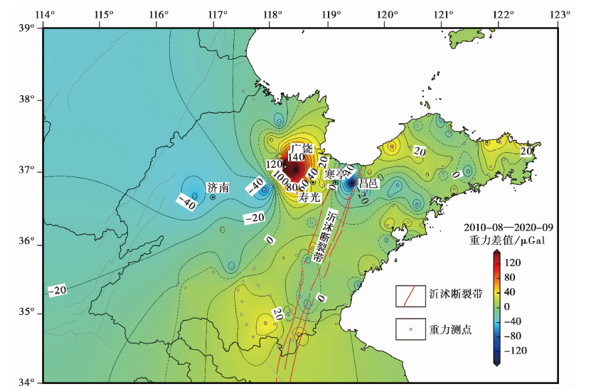
图1 2010-08-2020-09原始重力变化图
Fig. 1 Spatial variation of 2020-09 original gravity variation in comparison to the 2010-08 data.
| 震级/MS | 4 | 5 | 6 | 7 | 8 | |
|---|---|---|---|---|---|---|
| 重力变化量级/μGal | 胡敏章等( | 25 | 49 | 73 | 96 | 120 |
| 胡敏章等( | 28 | 50 | 72 | 93 | 115 | |
| 祝意青等( | ≥50 | ≥80 | ≥100 | ≥120 | ||
| 重力变化平面范围/km | 贾民育等( | 160 | 300 | 440 | 580 | |
| 祝意青等( | 100 | 200 | 400 | 600 | ||
| 胡敏章等( | 140 | 220 | 350 | 660 | ||
| 异常时间/a | 祝意青等( | 0.5~1 | 1~3 | 3~5 | ≥5 |
表2 重力变化与震级的定量指标
Table2 Quantitative indexes of gravity variation and seismic magnitude
| 震级/MS | 4 | 5 | 6 | 7 | 8 | |
|---|---|---|---|---|---|---|
| 重力变化量级/μGal | 胡敏章等( | 25 | 49 | 73 | 96 | 120 |
| 胡敏章等( | 28 | 50 | 72 | 93 | 115 | |
| 祝意青等( | ≥50 | ≥80 | ≥100 | ≥120 | ||
| 重力变化平面范围/km | 贾民育等( | 160 | 300 | 440 | 580 | |
| 祝意青等( | 100 | 200 | 400 | 600 | ||
| 胡敏章等( | 140 | 220 | 350 | 660 | ||
| 异常时间/a | 祝意青等( | 0.5~1 | 1~3 | 3~5 | ≥5 |
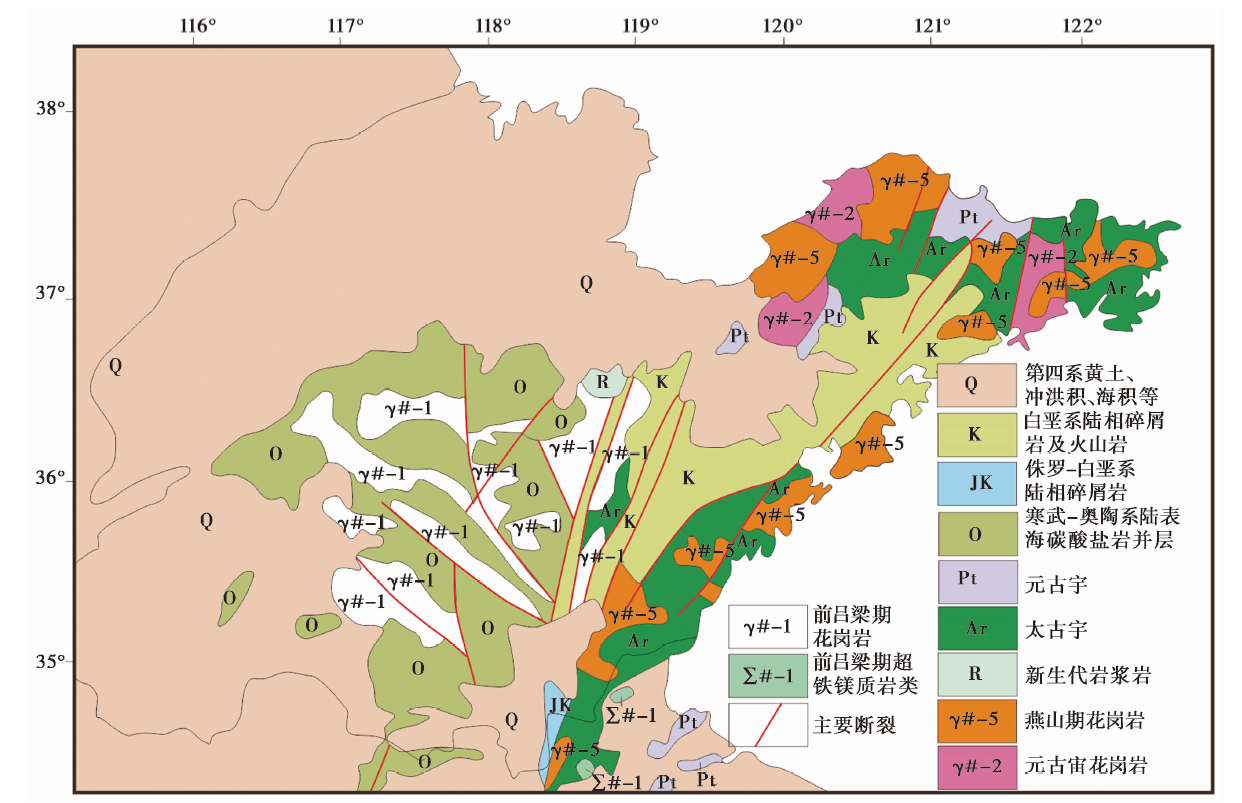
图2 沂沭断裂带及周边地区的地层分布图
Fig. 2 Strata distribution of Yishu fault zone and its surrounding areas.
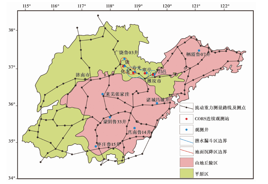
图3 山东省流动重力测量路线及观测井、 CORS站分布图
Fig. 3 The repeated gravimetry network, observation wells and CORS stations in Shandong Province.
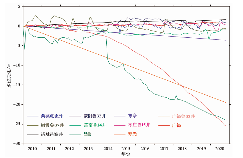
图4 观测井水位变化时序图
Fig. 4 Time sequence diagram of observed well water level variations.
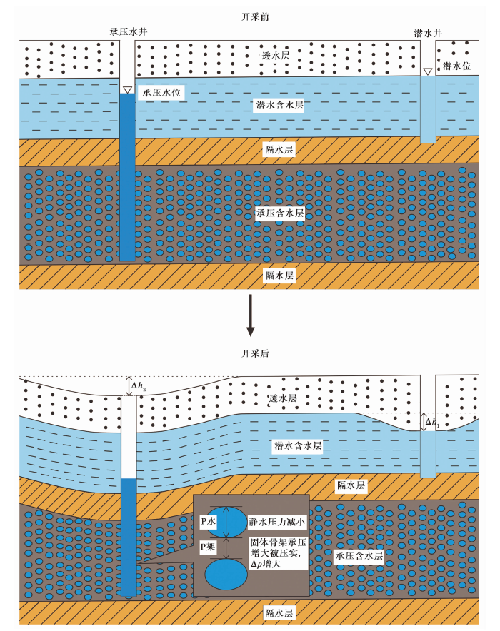
图8 地下水开采及地面沉降示意图
Fig. 8 Schematic diagram of groundwater exploitation and land subsidence process.
| 岩性分类 | 卵砾石 | 粗砂 | 中砂 | 细砂 | 粉细砂 | 粉砂 | 粉土 | 粉质黏土 | 黏土 |
|---|---|---|---|---|---|---|---|---|---|
| 山前平原 | 0.25 | 0.195 | 0.165 | 0.15 | 0.127 5 | 0.11 | 0.08 | 0.054 | 0.035 |
| 中东部平原 | 0.23 | 0.15 | 0.13 | 0.12 | 0.1 | 0.097 | 0.062 | 0.045 | 0.028 |
| 古黄河冲洪积平原 | 0.18 | 0.13 | 0.12 | 0.1 | 0.082 5 | 0.067 | 0.053 | 0.038 | 0.035 |
表3 岩性分类及单一岩性的μ值(钱永, 2007)
Table3 Lithologic classification and single lithologic μ values(adapted from QIAN Yong, 2007)
| 岩性分类 | 卵砾石 | 粗砂 | 中砂 | 细砂 | 粉细砂 | 粉砂 | 粉土 | 粉质黏土 | 黏土 |
|---|---|---|---|---|---|---|---|---|---|
| 山前平原 | 0.25 | 0.195 | 0.165 | 0.15 | 0.127 5 | 0.11 | 0.08 | 0.054 | 0.035 |
| 中东部平原 | 0.23 | 0.15 | 0.13 | 0.12 | 0.1 | 0.097 | 0.062 | 0.045 | 0.028 |
| 古黄河冲洪积平原 | 0.18 | 0.13 | 0.12 | 0.1 | 0.082 5 | 0.067 | 0.053 | 0.038 | 0.035 |
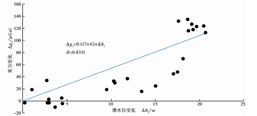
图5 重力变化与潜水位变化的相关性拟合
Fig. 5 Correlation fitting between gravity variation and water level variation.
| 观测井 | 广饶 | 昌邑市 | 寿光市 | 寒亭区 |
|---|---|---|---|---|
| 水位变化/m | 1.05 | -20.80 | -18.15 | -3.39 |
| 重力改正/μGal | 5.16 | -102.21 | -89.19 | -16.66 |
表4 地下水位校正结果统计表
Table4 Statistical table of groundwater level correction results
| 观测井 | 广饶 | 昌邑市 | 寿光市 | 寒亭区 |
|---|---|---|---|---|
| 水位变化/m | 1.05 | -20.80 | -18.15 | -3.39 |
| 重力改正/μGal | 5.16 | -102.21 | -89.19 | -16.66 |
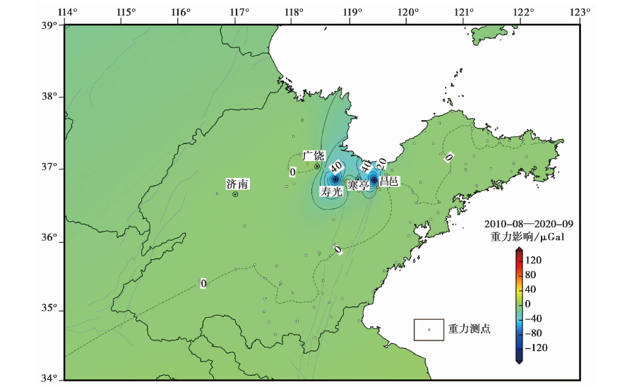
图6 潜水变化对重力观测影响的分布图
Fig. 6 Distribution of influence of phreatic variation on gravimetry.
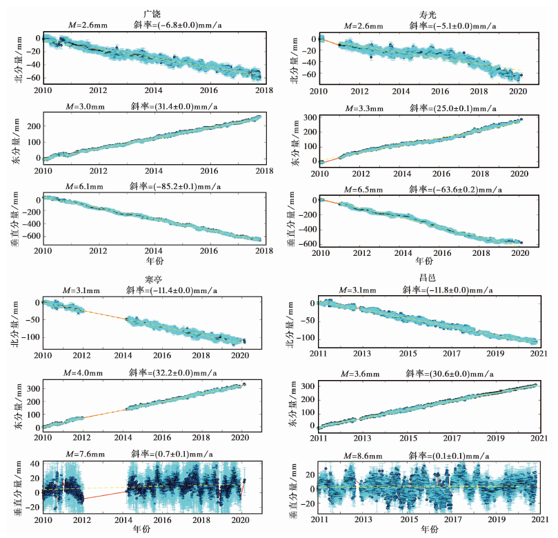
图7 广饶、 寿光、 寒亭、 昌邑CORS站的时变数据
Fig. 7 Time-varying data of CORS stations in Guangrao, Shouguang, Hanting and Changyi.
| CORS站 | 广饶 | 寿光 | 寒亭 | 昌邑 |
|---|---|---|---|---|
| 垂向年变/m | -85.2 | -63.6 | 0.7 | 0.1 |
| 垂向累计变化/mm | -866.2 | -646.6 | 7.1 | 1.0 |
| 重力改正量/μGal | 190.56 | 142.25 | -1.56 | -0.22 |
表5 地表形变及校正结果统计表
Table5 Statistical table of surface deformation and correction results
| CORS站 | 广饶 | 寿光 | 寒亭 | 昌邑 |
|---|---|---|---|---|
| 垂向年变/m | -85.2 | -63.6 | 0.7 | 0.1 |
| 垂向累计变化/mm | -866.2 | -646.6 | 7.1 | 1.0 |
| 重力改正量/μGal | 190.56 | 142.25 | -1.56 | -0.22 |
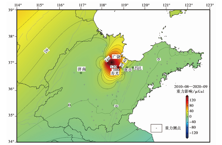
图9 地表形变对重力观测影响分布图
Fig. 9 Distribution diagram of influence of surface deformation on gravimetry.
| 测点 | 广饶 | 寿光 | 昌邑 |
|---|---|---|---|
| 重力实测变化/μGal | 196 | 19 | -130 |
| 地下水校正/μGal | -5.16 | 89.19 | 102.21 |
| 沉降校正/μGal | -190.56 | -142.25 | 0.22 |
| 综合干扰/μGal | 195.72 | 53.06 | -102.43 |
| 校正后重力变化/μGal | 0.28 | -34.06 | -27.57 |
表6 地下水及地面沉降校正结果
Table6 Correction results of groundwater and land subsidence
| 测点 | 广饶 | 寿光 | 昌邑 |
|---|---|---|---|
| 重力实测变化/μGal | 196 | 19 | -130 |
| 地下水校正/μGal | -5.16 | 89.19 | 102.21 |
| 沉降校正/μGal | -190.56 | -142.25 | 0.22 |
| 综合干扰/μGal | 195.72 | 53.06 | -102.43 |
| 校正后重力变化/μGal | 0.28 | -34.06 | -27.57 |
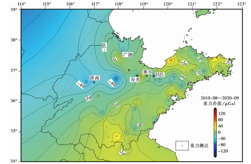
图10 2010-08-2020-09校正后的重力变化图
Fig. 10 Gravity variation of 2010-08-2020-09 after correction.
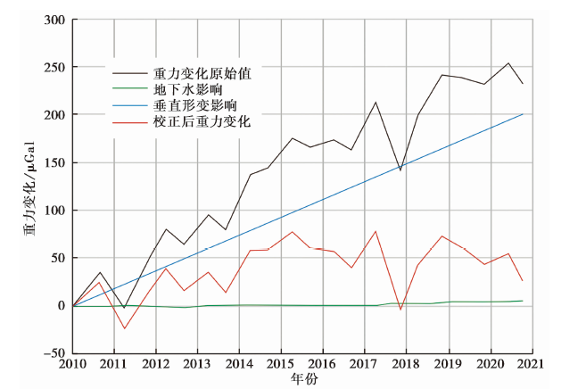
图11 广饶测点的重力变化时序图
Fig. 11 Time sequence diagram of gravity variation in Guangrao.
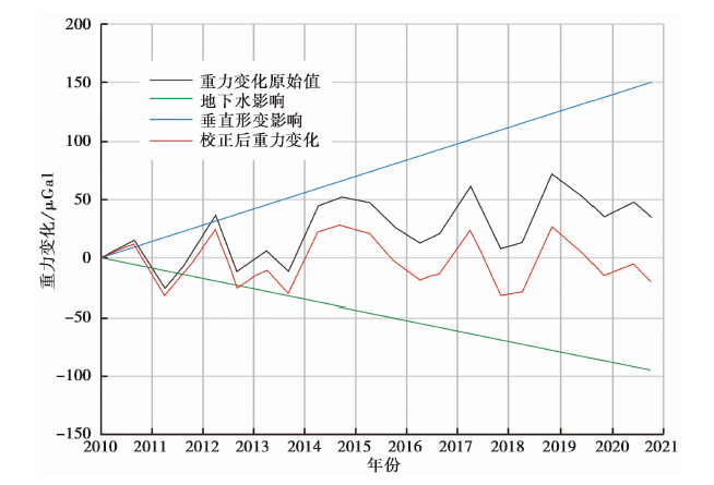
图12 寿光测点的重力变化时序图
Fig. 12 Time sequence diagram of gravity variation in Shouguang.
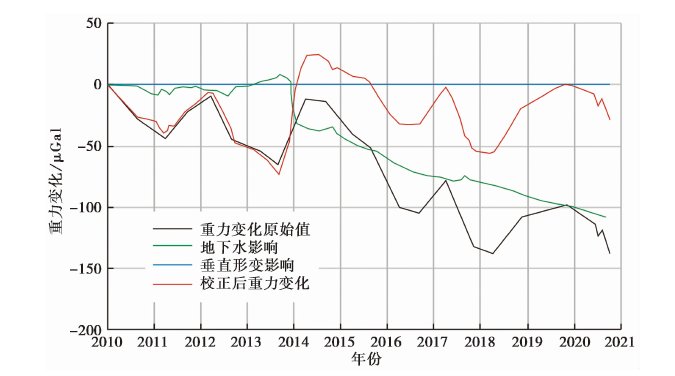
图13 昌邑测点的重力变化时序图
Fig. 13 Time sequence diagram of gravity variation in Changyi.
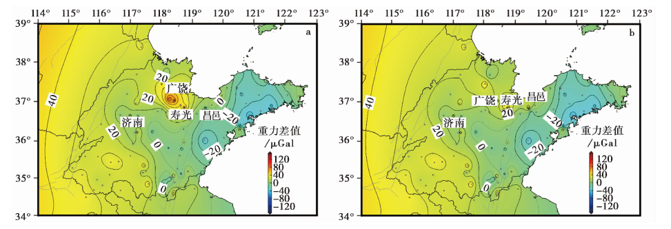
图14 2018-03-2021-03重力变化图 a 2018-03-2021-03重力变化图(校正前); b 2018-03-2021-03重力变化图(校正后)
Fig. 14 Spatial gravity variation of 2021-03 in comparison to the 2018-03 data.
| [1] |
曹滨. 2017. 潍坊北部地下水漏斗成因机理与演变规律研究[D]. 泰安: 山东农业大学.
|
|
|
|
| [2] |
晁洪太, 李家灵, 崔昭文, 等. 1995. 郯庐活断层与1668年郯城8.5级地震灾害[J]. 海洋地质与第四纪地质, 15(3): 69-80.
|
|
|
|
| [3] |
范尧, 黄旭, 陆海玉, 等. 2016. 松散介质型地下水库地下水系统特征与库容计算分析探讨[J]. 资源环境与工程, 30(3): 489-496.
|
|
|
|
| [4] |
胡斌, 祝意青, 徐云马, 等. 2005. 西安地区重力场时空变化特征研究[J]. 大地测量与地球动力学, 25(1): 86-90.
|
|
|
|
| [5] |
胡敏章, 郝洪涛, 李辉, 等. 2019. 地震分析预报的重力变化异常指标分析[J]. 中国地震, 35(3): 417-430.
|
|
|
|
| [6] |
华昌才, 果勇, 刘端法, 等. 1995. 首都圈地区重力场的时空变化[J]. 地震学报, 17(3): 347-352.
|
|
|
|
| [7] |
贾金生, 田冰, 刘昌明. 2003. Visual MODFLOW在地下水模拟中的应用--以河北省栾城县为例[J]. 河北农业大学学报, 26(2): 71-78.
|
|
|
|
| [8] |
贾民育, 游泽霖, 万素凡, 等. 1983. 地下水活动对精密重力测量的影响及排除方法[J]. 地壳形变与地震, 3(1): 50-67.
|
|
|
|
| [9] |
贾民育, 詹洁晖. 2000. 中国地震重力监测体系的结构与能力[J]. 地震学报, 22(4): 360-367.
|
|
|
|
| [10] |
李杰, 于澄, 朱成林, 等. 2018. 沂沭断裂带及附近地区垂直形变特征分析[J]. 地震, 38(1): 167-177.
|
|
|
|
| [11] |
李佩成. 1999. 黄土含水层给水度合理取值的研究[J]. 水力学报, 43(11): 38-41.
|
|
|
|
| [12] |
李树鹏, 张春鹏, 李国一, 等. 2020. 地下水漏斗对昌邑-新河相对重力观测的影响[J]. 大地测量与地球动力学, 40(11): 1129-1132.
|
|
|
|
| [13] |
刘咏明, 崔圆圆, 邵震. 2015. 黄河三角洲南部冲洪积扇区浅层地下水漏斗研究[J]. 山东国土资源, 31(12): 33-36.
|
|
|
|
| [14] |
马海丽. 2015. 黄河三角洲典型区地下水动态及其与土壤盐渍化的关系[D]. 济南: 济南大学.
|
|
|
|
| [15] |
裴源生, 李旭东, 赵勇, 等. 2020. 华北典型地下水大深埋区潜水层垂向补给特征及其给水度[J]. 南水北调与水利科技, 18(1): 176-193.
|
|
|
|
| [16] |
钱永. 2007. 开采条件下华北平原浅层地下水系统演变研究[D]. 北京: 中国地质科学院.
|
|
|
|
| [17] |
任虎兴. 2017. 华北平原古河道地裂缝的成因机理探讨[D]. 西安: 长安大学.
|
|
|
|
| [18] |
孙景林, 刘英昊, 宋芳. 2018. 潍坊市潍北区地下水模型研究[J]. 地下水, 40(2): 35-37.
|
|
|
|
| [19] |
孙晓明. 2007. 环渤海地区地下水资源可持续利用研究[D]. 北京: 中国地质大学.
|
|
|
|
| [20] |
孙晓明, 王卫东, 徐建国, 等. 2007. 环渤海地区地下水库开发利用前景[J]. 地质调查与研究, 30(1): 54-61.
|
|
|
|
| [21] |
王晓兵, 张为民, 钟敏. 2009. 净月潭水库蓄水对长春基准站绝对重力变化的影响[J]. 大地测量与地球动力学, 29(5): 72-75.
|
|
|
|
| [22] |
王志才, 王冬雷, 许洪泰, 等. 2015. 安丘-莒县断裂北段几何结构与最新活动特征[J]. 地震地质, 37(1): 176-191. doi: 10.3969/j.issn.0253-4967.2015.01.014.
DOI |
|
|
|
| [23] |
徐锡伟, 吴熙彦, 于贵华, 等. 2017. 中国大陆高震级地震危险区判定的地震地质学标志及其应用[J]. 地震地质, 39(2): 219-275. doi: 10.3969/j.issn.0253-4967.2017.02.001.
DOI |
|
|
|
| [24] |
殷海涛, 甘卫军, 黄蓓, 等. 2013. 日本M9.0巨震对山东地区地壳活动的影响研究[J]. 地球物理学报, 56(5): 1497-1505.
|
|
|
|
| [25] |
殷海涛, 李杰, 张玲, 等. 2008. 基于GPS观测网的山东地区地壳运动特征分析[J]. 工程地震学报, 30(3): 276-281.
|
|
|
|
| [26] |
岳建利, 何志堂, 祝意青, 等. 2008. 利用绝对重力测量对大地原点地下水沉降的研究[J]. 测绘科学, 33(S2): 22-24, 39.
|
|
|
|
| [27] |
张坤. 2017. 局部水文地质特征对地表重力观测影响研究[D]. 武汉: 中国地震局地震研究所.
|
|
|
|
| [28] |
张为民, 王勇. 2005. 洱海水位变化对下关基准点绝对重力观测的影响[J]. 大地测量与地球动力学, 25(4): 114-116.
|
|
|
|
| [29] |
张兆吉. 2009. 华北平原地下水可持续利用图集[M]. 北京: 科学出版社:72-75.
|
|
|
|
| [30] |
朱成林, 甘卫军, 李杰, 等. 2018. 日本 MW9.0 地震后沂沭断裂带两侧块体相对运动及对地震活动的影响[J]. 地球物理学报, 61(3): 988-999.
|
|
|
|
| [31] |
朱光, 王道轩, 刘国生, 等. 2001. 郯庐断裂带的伸展活动及其动力学背景[J]. 地质科学, 36(3): 269-278.
|
|
|
|
| [32] |
祝意青, 梁伟锋, 湛飞并, 等. 2012. 中国大陆重力场动态变化研究[J]. 地球物理学报, 55(3): 804-813.
|
|
|
|
| [33] |
祝意青, 申重阳, 张国庆, 等. 2018. 我国流动重力监测预报发展之再思考[J]. 大地测量与地球动力学, 38(5): 441-446.
|
|
|
|
| [34] |
DOI URL |
| [35] |
DOI URL |
| [36] |
DOI URL |
| [37] |
|
| [1] | 朱治国, 祝意青, 王东振, 艾力夏提·玉山. 2020年伽师MS6.4地震重力与地壳形变综合分析[J]. 地震地质, 2023, 45(1): 269-285. |
| [2] | 廖桂金, 叶东华, 邓志辉, 李翀, 唐国英, 胡伟明. 地震重力异常与地面沉降重力异常的特征分析[J]. 地震地质, 2022, 44(4): 895-908. |
| [3] | 王力伟, 王宝善, 叶秀薇, 张云鹏, 王小娜, 吕作勇. 基于人工地震资料的珠江口地区最小一维P波速度模型[J]. 地震地质, 2021, 43(1): 123-143. |
| [4] | 王璞, 王成虎, 王洪, 陈念, 周昊, 魏学勇. 利用孔壁竖向裂缝方位数据分析沂沭断裂带的地应力场特征[J]. 地震地质, 2020, 42(6): 1316-1334. |
| [5] | 刘晓东, 单新建, 张迎峰, 尹昊, 屈春燕. 基于强震记录的汶川地震同震形变场及滑动反演[J]. 地震地质, 2019, 41(4): 1027-1041. |
| [6] | 陈兆辉, 孟小红, 张双喜, 刘金钊, 王同庆, 张品, 韦少港. 青藏高原东南缘多尺度重力场变化特征及孕震机理分析[J]. 地震地质, 2019, 41(3): 690-703. |
| [7] | 李铁明, 徐云马, 杨永林, 冯胜涛. 鲜水河断裂带地区重力场动态变化及其与5级以上地震的关系[J]. 地震地质, 2018, 40(6): 1362-1379. |
| [8] | 陈鲲, 俞言祥, 高孟潭, 亢川川. 不同约束条件下2014年8月24日纳帕MW6.0地震峰值加速度震动图的对比[J]. 地震地质, 2018, 40(2): 440-449. |
| [9] | 朱成林, 甘卫军, 贾媛, 李杰, 殷海涛, 孔向阳. 沂沭断裂带两侧地区地震能量释放与块体相对运动的关系[J]. 地震地质, 2018, 40(2): 299-309. |
| [10] | 王庆林, 孙怀凤, 朱成林, 张继红, 唐廷梅. 基于长周期视电阻率时间序列的深部构造应力变化——以沂沭断裂带北段为例[J]. 地震地质, 2017, 39(1): 147-157. |
| [11] | 王鑫, 张景发, 付萍杰, 高敏. 沂沭断裂带重力场及地壳结构特征[J]. 地震地质, 2015, 37(3): 731-747. |
| [12] | 陈鲲, 俞言祥, 高孟潭, 高景春. 利用强震记录校正的芦山7.0级地震峰值加速度震动图[J]. 地震地质, 2013, 35(3): 627-633. |
| [13] | 朱桂芝, 石耀霖, 祝意青, 王庆良. 遗传有限元法反演西安地区的地层密度变化[J]. 地震地质, 2008, 30(2): 544-552. |
| [14] | 尹金辉, 郑勇刚, 刘粤霞. 液闪法测量断裂带水中3H计数效率的标定[J]. 地震地质, 2006, 28(4): 663-667. |
| [15] | 尹金辉, 郑勇刚, 刘粤霞. 古地震14C年龄的日历年代校正[J]. 地震地质, 2005, 27(4): 678-688. |
| 阅读次数 | ||||||
|
全文 |
|
|||||
|
摘要 |
|
|||||
