地震地质 ›› 2023, Vol. 45 ›› Issue (1): 153-171.DOI: 10.3969/j.issn.0253-4967.2023.01.009
靳立周1)( ), 王盈2), 常文斌3), 田颖颖1), 袁仁茂1),*()
收稿日期:2022-03-23
修回日期:2022-06-08
出版日期:2023-02-20
发布日期:2023-03-24
通讯作者:
* 袁仁茂, 男, 1972年生, 研究员, 主要研究方向为地质灾害、 活动构造, E-mail: yuanrenmao@ies.ac.cn。
作者简介:靳立周, 男, 1996年生, 2021年于中国地震局地质研究所获构造地质学专业硕士学位, 研究方向为地震地质灾害, E-mail: jinlizhou2021@163.com。
基金资助:
JIN Li-zhou1)(), WANG Ying2), CHANG Wen-bin3), TIAN Ying-ying1), YUAN Ren-mao1),*()
Received:2022-03-23
Revised:2022-06-08
Online:2023-02-20
Published:2023-03-24
摘要:
2018年10月11日和11月3日, 位于金沙江上游右岸的西藏江达县波罗乡白格村先后发生了2次特大规模的滑坡堵江事件, 经人工干预后险情得以解除。运用差分干涉合成孔径雷达(D-InSAR)技术对白格滑坡后缘的潜在危岩体进行了7.5d连续不间断的监测, 结果表明: 滑坡体上侧区域目前仍然不稳定, 具有再次发生滑坡堵江的危险。基于此, 文中利用颗粒流软件PFC2D模拟了滑坡后缘潜在危岩体在自身重力、 强降雨、 地震条件下的稳定性状况。模拟结果表明: 后缘潜在危岩体在静力作用下不会产生明显的失稳滑动, 在强降雨和强地震动条件下会发生失稳破坏, 可能会再次堵塞金沙江并形成堰塞湖。根据文中的模拟结果可对滑坡稳定性做出科学评价, 同时为以后类似滑坡的防灾减灾提供参考。
中图分类号:
靳立周, 王盈, 常文斌, 田颖颖, 袁仁茂. 基于D-InSAR和PFC2D技术的白格滑坡稳定性分析[J]. 地震地质, 2023, 45(1): 153-171.
JIN Li-zhou, WANG Ying, CHANG Wen-bin, TIAN Ying-ying, YUAN Ren-mao. STABILITY ANALYSIS OF THE BAIGE LANDSLIDE USING D-INSAR AND PFC2D MODELING[J]. SEISMOLOGY AND GEOLOGY, 2023, 45(1): 153-171.
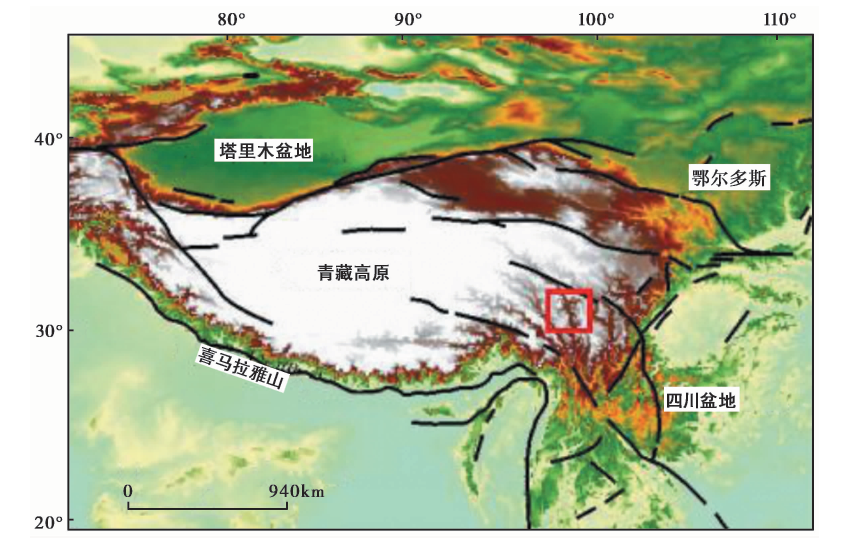
图1 白格区域构造背景图(改自Ren等, 2018) 红框为白格滑坡发生区域
Fig. 1 Tectonic setting of the Baige area(after Ren et al., 2018).
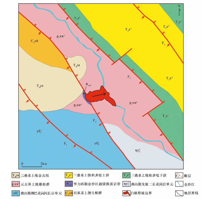
图2 滑坡区地质图
Fig. 2 Geology of the Baige landslide.
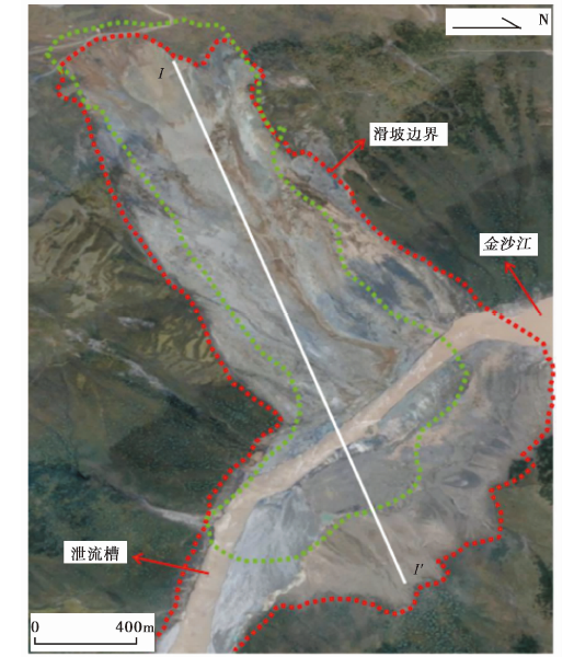
图3 白格滑坡全区地貌图 红色虚线代表2018年10月11日的滑坡边界, 绿色虚线代表2018年11月3日的滑坡边界
Fig. 3 Geomorphology of the Baige landslide.
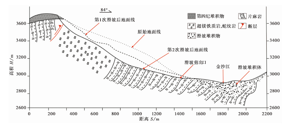
图4 白格滑坡地质剖面图(II')
Fig. 4 The geological section II' in the Baige landslide area.
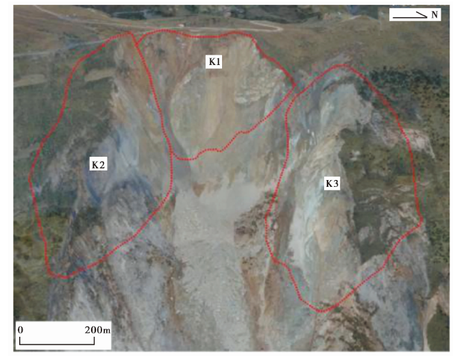
图5 滑坡后缘的危岩体 K1、 K2、 K3为滑坡后缘的变形体
Fig. 5 Unstable rocks of trailing edge of the Baige landslide.
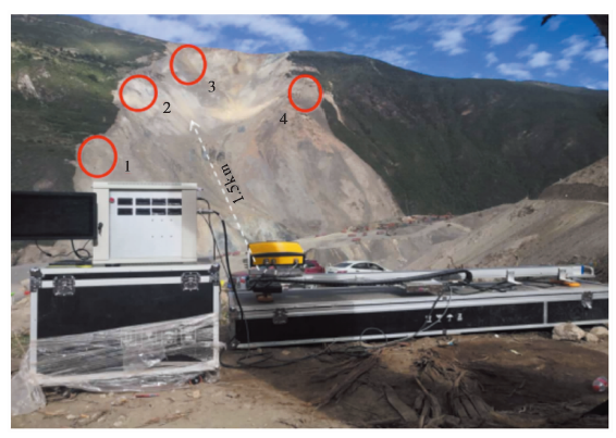
图6 雷达监测到的形变重点区域图
Fig. 6 The major deformation areas defected by radar.
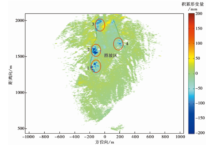
图7 雷达监测滑坡体的形变结果
Fig. 7 Landslide’s deformation detected by radar.
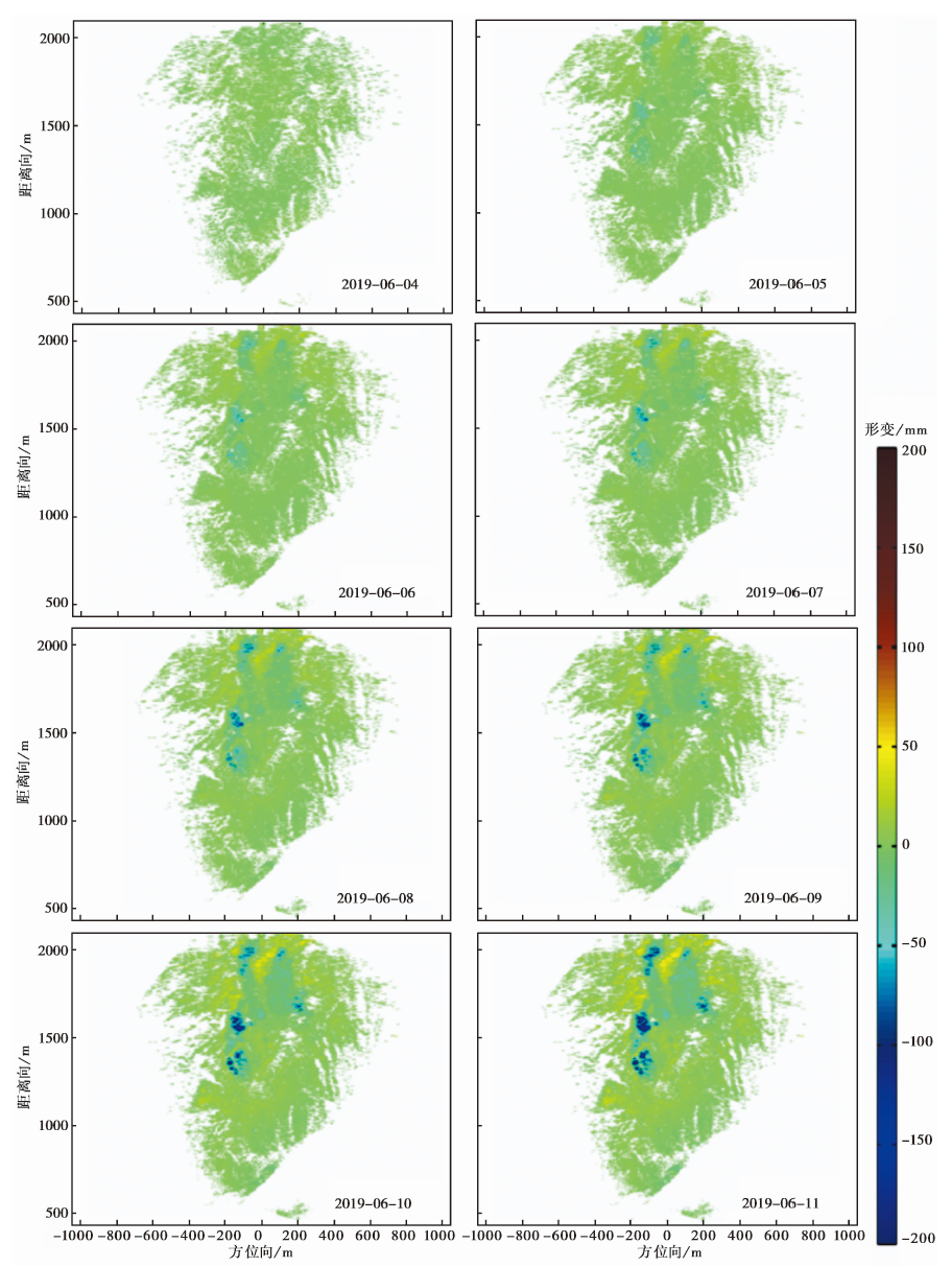
图8 金沙江白格滑坡地基雷达形变时间序列图
Fig. 8 Time-series deformation of the Baige landslide in Jinsha River defected by ground-based radar.
| 区域 | 点位 | 累积形变量/mm |
|---|---|---|
| 1 | (-176, 1352) | 222 |
| 2 | (-139, 1609) | 227 |
| 3 | (-97.5, 1969) | 207 |
| 4 | (206, 1675) | 170 |
表1 雷达监测点位的累积形变量
Table1 Cumulative deformation amount of the radar monitoring sites
| 区域 | 点位 | 累积形变量/mm |
|---|---|---|
| 1 | (-176, 1352) | 222 |
| 2 | (-139, 1609) | 227 |
| 3 | (-97.5, 1969) | 207 |
| 4 | (206, 1675) | 170 |
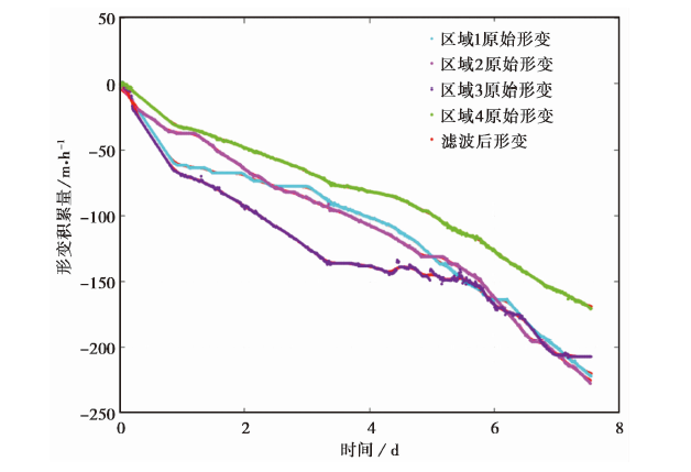
图9 区域形变累积曲线
Fig. 9 Accumulative deformation curves in the landslide area.
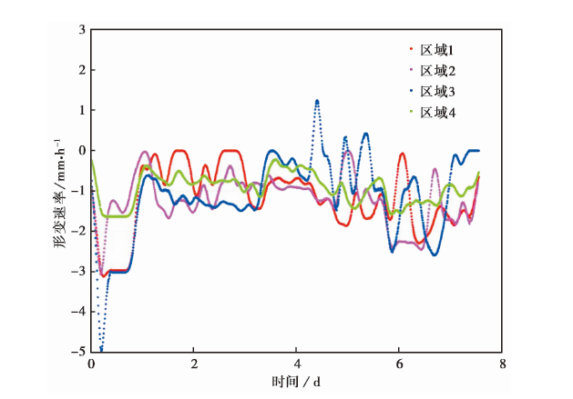
图10 区域形变速率曲线
Fig. 10 The regional deformation rate curves.
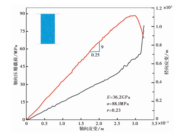
图11 PFC2D单轴压缩实验模型
Fig. 11 The uniaxial compression test of PFC2D.
| 类别 | 杨氏模量E/GPa | 单轴抗压强度UCS/MPa | 泊松比 |
|---|---|---|---|
| 室内单轴压缩试验 | 36.4 | 87.7 | 0.22 |
| PFC单轴压缩试验 | 36.2 | 88.1 | 0.23 |
表2 室内测定岩石强度参数
Table2 Rock strength parameters measured indoors
| 类别 | 杨氏模量E/GPa | 单轴抗压强度UCS/MPa | 泊松比 |
|---|---|---|---|
| 室内单轴压缩试验 | 36.4 | 87.7 | 0.22 |
| PFC单轴压缩试验 | 36.2 | 88.1 | 0.23 |
| 类别 | 自然情况 | 降雨情况 |
|---|---|---|
| 颗粒半径R/m | 0.15~0.5 | 0.15~0.5 |
| 颗粒数目 | 11 | 11 |
| 颗粒密度/kg·m-3 | ||
| 摩擦系数Fric | 0.45 | 0.40 |
| 法向黏结强度 | 1.8×10⁶ | 1.2×10⁶ |
| 切向黏结强度 | 9×10⁵ | 6×10⁵ |
| 平行黏结法向刚度 | 3×10⁸ | 2×10⁸ |
| 平行黏结切向刚度 | 1.5×10⁸ | 1×10⁸ |
表3 滑坡岩土体颗粒细观力学参数
Table3 Meso-mechanical parameters of rock and soil particles from landslide
| 类别 | 自然情况 | 降雨情况 |
|---|---|---|
| 颗粒半径R/m | 0.15~0.5 | 0.15~0.5 |
| 颗粒数目 | 11 | 11 |
| 颗粒密度/kg·m-3 | ||
| 摩擦系数Fric | 0.45 | 0.40 |
| 法向黏结强度 | 1.8×10⁶ | 1.2×10⁶ |
| 切向黏结强度 | 9×10⁵ | 6×10⁵ |
| 平行黏结法向刚度 | 3×10⁸ | 2×10⁸ |
| 平行黏结切向刚度 | 1.5×10⁸ | 1×10⁸ |
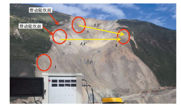
图12 滑坡后缘的滑动陡坎面
Fig. 12 The scarp at trailing edge of landslide.
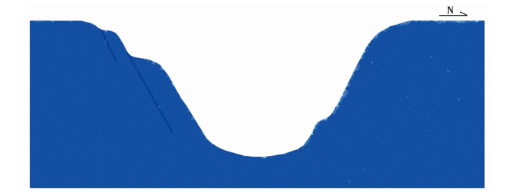
图13 Ball-Ball模型
Fig. 13 Ball-Ball model.
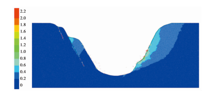
图14 静力作用下的边坡位移图
Fig. 14 Slop displacement diagram under the influence of static force.
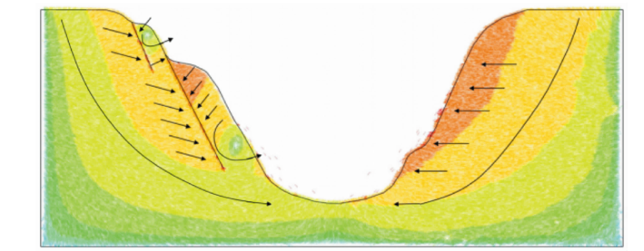
图15 静力作用下的边坡位移趋势图
Fig. 15 Tendency of slop displacement under the influence of static force.
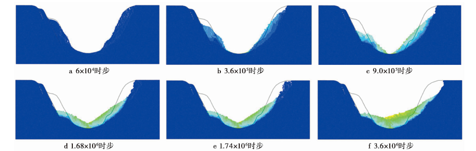
图16 强降雨作用下的边坡破坏颗粒位移云图
Fig. 16 Slop failure process under the influence of heavy rain.
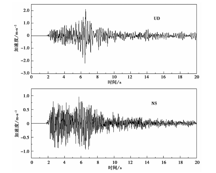
图17 地震动加速度时程曲线
Fig. 17 Time history curve of ground motion acceleration.
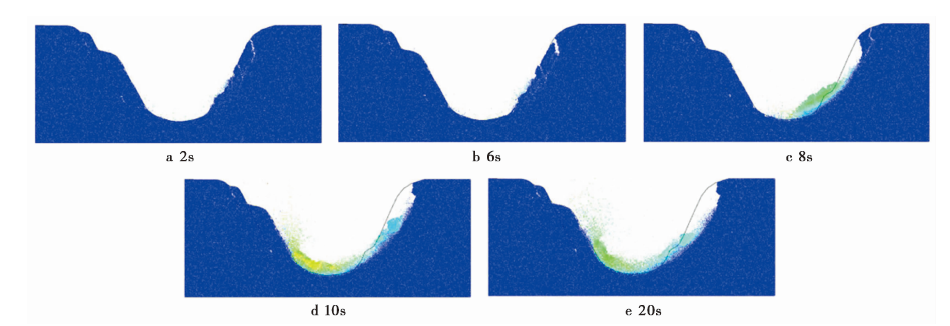
图18 地震作用下的颗粒位移云图
Fig. 18 Slop failure process under the influence of earthquake.
| [1] | 曹文, 李维朝, 唐斌, 等. 2017. PFC滑坡模拟二、 三维建模方法研究[J]. 工程地质学报, 25(2): 455462. |
| CAO Wen, LI Wei-chao, TANG Bin, et al. 2017. PFC study on building of 2D and 3D landslide models[J]. Journal of Engineering Geology, 25(2): 455462. (in Chinese) | |
| [2] | 柴贺军, 刘汉超, 张倬元. 2000. 中国堵江滑坡发育分布特征[J]. 山地学报, 18(S1): 5154. |
|
CHAI He-jun, LIU Han-chao, ZHANG Zhuo-yuan. 2000. The temporal-spatial distribution of damming landslides in China[J]. Journal of Mountain Science, 18(S1): 5154. (in Chinese)
DOI |
|
| [3] | 陈祖煜, 陈生水, 王琳, 等. 2020. 金沙江上游“11·03”白格堰塞湖溃决洪水反演分析[J]. 中国科学, 50(6): 763774. |
| CHEN Zu-yu, CHEN Sheng-shui, WANG Lin, et al. 2020. Back analysis of the breach flood of the “11.03” Baige barrier lake at the Upper Jinsha River[J]. Science in China, 50(6): 763774. (in Chinese) | |
| [4] | 邓建辉, 高云建, 余志球, 等. 2019. 堰塞金沙江上游的白格滑坡形成机制与过程分析[J]. 工程科学与技术, 51(1): 916. |
| DENG Jian-hui, GAO Yun-jian, YU Zhi-qiu, et al. 2019. Analysis on the formation mechanism and process of Baige landslides damming the upper reach of Jinsha River, China[J]. Advanced Engineering Sciences, 51(1): 916. (in Chinese) | |
| [5] | 冯文凯, 张国强, 白慧林, 等. 2019. 金沙江“10·11”白格特大型滑坡形成机制及发展趋势初步分析[J]. 工程地质学报, 27(2): 415425. |
| FENG Wen-kai, ZHANG Guo-qiang, BAI Hui-lin, et al. 2019. A preliminary analysis of the formation mechanism and development tendency of the huge Baige landslide in Jinsha River on October 11, 2018[J]. Journal of Engineering Geology, 27(2): 415425. (in Chinese) | |
| [6] | 郭晨, 许强, 彭双麒, 等. 2020. 无人机摄影测量技术在金沙江白格滑坡应急抢险中的应用[J]. 灾害学, 35(1): 203210. |
| GUO Chen, XU Qiang, PENG Shuang-qi, et al. 2020. Application research of UAV photogrammetry technology in the emergency rescue of Baige landslide[J]. Journal of Catastrophology, 35(1): 203210. (in Chinese) | |
| [7] | 胡卸文, 黄润秋, 施裕兵, 等. 2009. 唐家山滑坡堵江机制及堰塞坝溃坝模式分析[J]. 岩石力学与工程学报, 28(1): 181189. |
| HU Xie-wen, HUANG Run-qiu, SHI Yu-bing, et al. 2009. Analysis of blocking river mechanism of Tangjiashan landslide and dam-breaking mode of its barrier dam[J]. Journal of Rock Mechanics and Engineering, 28(1): 181189. (in Chinese) | |
| [8] | 雷远见, 王水林. 2006. 基于离散元的强度折减法分析岩质边坡稳定性[J]. 岩土力学, 27(10): 16931698. |
| LEI Yuan-jian, WANG Shui-lin. 2006. Stability analysis of jointed rock slope by strength reduction method based on UDEC[J]. Rock and Soil Mechanics, 27(10): 16931698. (in Chinese) | |
| [9] | 梁鑫, 郑立宁. 2011. 土石碎屑体稳定性离散元数值分析[J]. 铁道建筑, (2): 9193. |
| LIANG Xin, ZHENG Li-ning. 2011. Discrete element numerical analysis of the stability for soil-stone fragment body[J]. Railway Engineering, (2): 9193. (in Chinese) | |
| [10] | 刘婧雯, 黄博, 邓辉, 等. 2014. 地震作用下堆积体边坡振动台模型试验及抛出现象分析[J]. 岩土工程学报, 36(2): 307311. |
| LIU Jing-wen, HUANG Bo, DENG Hui, et al. 2014. Shaking table tests and throwing phenomenon of deposit slopes under earthquakes[J]. Chinese Journal of Geotechnical Engineering, 36(2): 307311. (in Chinese) | |
| [11] | 齐麟, 孔祥意, 袁鑫, 等. 2020. 基于D-InSAR技术的金沙江地区滑坡形变监测与分析[J]. 测绘与空间地理信息, 43(2): 175177, 181. |
| QI Lin, KONG Xiang-yi, YUAN Xin, et al. 2020. Monitoring and analysis of landslide deformation in Jinshajiang area based on D-InSAR technology[J]. Geomatics and Spatial Information Technology, 43(2): 175177, 181. (in Chinese) | |
| [12] | 石崇, 张强, 王盛年. 2012. 颗粒流(PFC5.0)数值模拟技术及应用[M]. 北京: 中国建筑工业出版社. |
| SHI Chong, ZHANG Qiang, WANG Sheng-nian. 2012. Numerical Simulation Technology and Application with Partical Flow Code(PFC5.0)[M]. China Building Industry Press, Beijing. (in Chinese) | |
| [13] | 王桂杰, 谢谟文, 邱骋, 等. 2010. D-InSAR技术在大范围滑坡监测中的应用[J]. 岩土力学, 31(4): 13371344. |
| WANG Gui-jie, XIE Mo-wen, QIU Cheng, et al. 2010. Application of D-InSAR technique to landslide monitoring[J]. Rock and Soil Mechanics, 31(4): 13371344. (in Chinese) | |
| [14] | 王立朝, 温铭生, 冯振, 等. 2019. 中国西藏金沙江白格滑坡灾害研究[J]. 中国地质灾害与防治学报, 30(1): 19. |
| WANG Li-chao, WEN Ming-sheng, FENG Zhen, et al. 2019. Researches on the Baige landslide at Jinsha River, Tibet, China[J]. The Chinese Journal of Geological Hazard and Control, 30(1): 19. (in Chinese) | |
| [15] | 许强, 黄润秋, 殷跃平, 等. 2009. 2009年6·5重庆武隆鸡尾山崩滑灾害基本特征与成因机理初步研究[J]. 工程地质学报, 17(4): 433444. |
| XU Qiang, HUANG Run-qin, YIN Yue-ping, et al. 2009. The Jiweishan landslide of June 5, 2009 in Wulong, Chongqing: Characteristics and failure mechanism[J]. Journal of Engineering Geology, 17(4): 433444. (in Chinese) | |
| [16] | 许强, 郑光, 李为乐, 等. 2018. 2018年10月和11月金沙江白格2次滑坡-堰塞堵江事件分析研究[J]. 工程地质学报, 26(6): 15341551. |
| XU Qiang, ZHENG Guang, LI Wei-le, et al. 2018. Study on successive landslide damming events of Jinsha River in Baige Village on October 11 and November 3[J]. Journal of Engineering Geology, 26(6): 15341551. (in Chinese) | |
| [17] | 殷跃平, 王文沛, 张楠, 等. 2017. 强震区高位滑坡远程灾害特征研究: 以四川茂县新磨滑坡为例[J]. 中国地质, 44(5): 827841. |
| YIN Yue-ping, WANG Wen-pei, ZHANG Nan, et al. 2017. Long runout geological disaster initiated by the ridge-top rockslide in a strong earthquake area: A case study of the Xinmo landslide in Maoxian County, Sichuan Province[J]. Geology in China, 44(5): 827841. (in Chinese) | |
| [18] | 赵程, 范宣梅, 杨帆, 等. 2020. 金沙江白格滑坡运动过程分析及潜在不稳定岩体预测[J]. 科学技术与工程, 20(10): 38603867. |
| ZHAO Cheng, FAN Xuan-mei, YANG Fan, et al. 2020. Movement of Baige landslide in Jinsha River and prediction of potential unstable rock mass[J]. Science Technology and Engineering, 20(10): 38603867. (in Chinese) | |
| [19] | 赵永辉, 涂国祥, 次仁德吉, 等. 2020. 中国西藏金沙江白格滑坡变形特征及破坏模式研究[J]. 西藏科技, (5): 6770, 72. |
| ZHAO Yong-hui, TU Guo-xiang, TSERING De-ji, et al. 2020. Research on deformation characteristics and failure mode on the Baige landslide at Jinsha River, Tibet, China[J]. Tibet’s Science and Technology, (5): 6770, 72. (in Chinese) | |
| [20] | 周健, 王家全, 曾远, 等. 2009. 土坡稳定分析的颗粒流模拟[J]. 岩土力学, 30(1): 8690. |
| ZHOU Jian, WANG Jia-quan, ZENG Yuan, et al. 2009. Simulation of slope stability analysis by particle flow code[J]. Rock and Soil Mechanics, 30(1): 8690. (in Chinese) | |
| [21] | 周礼, 范宣梅, 许强, 等. 2019. 金沙江白格滑坡运动过程特征数值模拟与危险性预测研究[J]. 工程地质学报, 27(6): 13951404. |
| ZHOU Li, FAN Xuan-mei, XU Qiang, et al. 2019. Numerical simulation and hazard prediction on movement process characteristics of Baige landslide in Jinsha River[J]. Journal of Engineering Geology, 27(6): 13951404. (in Chinese) | |
| [22] |
Cundall P A, Hart R D. 1992. Numerical modeling of discontinua[J]. Engineering Computations, 9(2): 101113.
DOI URL |
| [23] | Hao M H, Xu Q, Yang L, et al. 2014. Physical modeling and movement mechanism of landslide-debris avalanches[J]. Rock and Soil Mechanics, 35(S1): 127132. |
| [24] |
Manzella I, Labiouse V. 2013. Empirical and analytical analyses of laboratory granular flows to investigate rock avalanche propagation[J]. Landslides, 10(1): 2336.
DOI URL |
| [25] |
Li M H, Zhang L, Ding C, et al. 2020. Retrieval of historical surface displacements of the Baige landslide from time-series SAR observations for retrospective analysis of the collapse event[J]. Remote Sensing of Environment, 240:111695.
DOI URL |
| [26] |
Ren J, Xu X, Zhang S, et al. 2018. Surface rupture of the 1933 M7.5 Diexi earthquake in eastern Tibet: Implications for seismogenic tectonics[J]. Geophysical Journal International, 212(3): 16271644.
DOI URL |
| [27] |
Ouyang C J, An H C, Zhou S, et al. 2019a. Insights from the failure and dynamic characteristics of two sequential landslides at Baige village along the Jinsha River, China[J]. Landslides, 16(7): 13971414.
DOI |
| [28] |
Ouyang C J, Zhao W, An H C, et al. 2019b. Early identification and dynamic processes of ridge-top rockslides: Implications from the Su Village landslide in Suichang County, Zhejiang Province, China[J]. Landslides, 16(4): 799813.
DOI |
| [29] | Yuan R M, Tang C L, Hu J C, et al. 2014. Mechanism of the Donghekou landslide triggered by the 2008 Wenchuan earthquake revealed by discrete element modeling[J]. Natural Hazards and Earth System Sciences, 14(5): 11951205. |
| [1] | 韩江涛, 王天琪, 刘文玉, 刘国兴, 韩松, 刘立家. 阿尔山火山群深部“拱桥式”岩浆系统及其稳定性分析[J]. 地震地质, 2018, 40(3): 590-610. |
| [2] | 左荣虎, 屈春燕, 张国宏, 单新建, 宋小刚, 温少妍, 徐小波. 基于Sentinel-1A数据获取美国纳帕MW6.1地震同震形变场及断层滑动反演[J]. 地震地质, 2016, 38(2): 278-289. |
| [3] | 屈春燕, 单新建, 宋小刚, 张桂芳, 张国宏, 郭利民, 刘云华, 韩宇飞. D-InSAR技术应用于汶川地震地表位移场的空间分析[J]. 地震地质, 2010, 32(2): 175-190. |
| [4] | 单新建, 张国宏. 孕震区震前D-InSAR干涉形变场动态演化图像分析[J]. 地震地质, 2006, 28(3): 441-446. |
| 阅读次数 | ||||||
|
全文 |
|
|||||
|
摘要 |
|
|||||
