地震地质 ›› 2023, Vol. 45 ›› Issue (2): 305-320.DOI: 10.3969/j.issn.0253-4967.2023.02.001
徐博1)( ), 王萍1),*(), 王慧颖1), 郭桥桥1), 石灵璠1), 石宇翔2)
收稿日期:2022-06-14
修回日期:2022-07-16
出版日期:2023-04-20
发布日期:2023-05-18
通讯作者:
*王萍, 女, 1964年生, 研究员, 博士生导师, 从事活动构造、构造地貌、第四纪年代学等方面的研究, E-mail: 作者简介:徐博, 男, 1995年生, 现为中国地震局地质研究所构造地质学专业在读博士研究生, 研究方向为第四纪地质学, E-mail: xb@ies.ac.cn。
基金资助:
XU Bo1)(), WANG Ping1),*(), WANG Hui-ying1), GUO Qiao-qiao1), SHI Ling-fan1), SHI Yu-xiang2)
Received:2022-06-14
Revised:2022-07-16
Online:2023-04-20
Published:2023-05-18
摘要:
青藏高原东南部的河谷中广泛分布堰塞湖、溃决洪水和风成沙等不同类型的沉积物, 利用粒度和形貌指标识别沉积物类型的相关研究还处于探索阶段。为了解洪水沉积物的粒度特征、空间分异规律及颗粒表面的微形貌特征, 我们在雅鲁藏布江中游加查峡谷出口-派镇长约350km范围内的全新世早期溃决洪水滞留沉积物中采集了33个样品, 利用Malvern 3000型激光衍射粒度仪、Zeiss Signma扫描电子显微镜进行测试, 结合数字地貌(DEM)数据提取的河道宽度、陡峭系数, 对粒度特征的空间分布规律进行分析, 取得以下认识: 溃决洪水滞留沉积粒度的总体特征为细-粉砂(2.57~5.18Φ), 分选较差, 呈正偏、窄峰态; 通过端元建模得出2个端元模型: EM1端元可能代表高山峡谷区溃决洪水能量较高的冲积特征, EM2端元可用来指示溃决洪水滞留沉积的堆积过程。溃决洪水滞留沉积的石英颗粒表面的微观结构特征以机械成因的擦痕、贝壳状断口、上翻解理及解理台阶为主, 化学成因的溶蚀孔洞较为少见。作为半湿润季风区河谷地带爬坡沙丘的典型代表, 位于下游河段的丹娘佛掌沙丘与已知溃决洪水滞留沉积的粒度特征及石英颗粒表面的微形貌特征相似, 我们认为佛掌沙丘的沙源主要来自溃决洪水沉积。
中图分类号:
徐博, 王萍, 王慧颖, 郭桥桥, 石灵璠, 石宇翔. 雅鲁藏布江中游全新世溃决洪水滞留沉积物粒度及微观结构特征分析[J]. 地震地质, 2023, 45(2): 305-320.
XU Bo, WANG Ping, WANG Hui-ying, GUO Qiao-qiao, SHI Ling-fan, SHI Yu-xiang. GRAIN SIZE AND MICROSTRUCTURE CHARACTERISTICS OF HOLOCENE MEGAFLOOD SLACK WATER DEPOSITS IN THE MIDDLE REACHES OF THE YARLUNG TSANGPO RIVER[J]. SEISMOLOGY AND GEOLOGY, 2023, 45(2): 305-320.

图1 a 研究区位置; b 采样点分布
Fig. 1 Overview of the study area(a) and sand sampling sites(b).
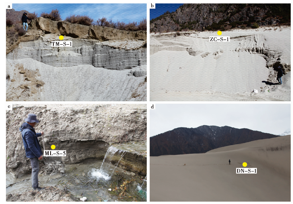
图2 沉积物的宏观特征及采样位置 a 平行层理, 洪水样TM-S-1, 采样地为塘麦村; b 平行层理, 洪水样ZC-S-1, 采样地为扎村; c 湖相纹层, ML-S-5, 采样地为米林北岸; d 风成沙丘, DN-S-1, 采样地为丹娘佛掌沙丘
Fig. 2 Macroscopic characteristics of flood deposition and schematic diagram of sampling points.
| 沙体类型 | 平均粒径Mz/Φ | 标准偏差SD | 偏度Sk | 峰态KG | ||||||||||||
|---|---|---|---|---|---|---|---|---|---|---|---|---|---|---|---|---|
| 平均值 | 最大值 | 最小值 | 平均值 | 最大值 | 最小值 | 平均值 | 最大值 | 最小值 | 平均值 | 最大值 | 最小值 | |||||
| 洪水(n=33) | 3.46 | 4.84 | 2.56 | 1.70 | 2.29 | 1.21 | 0.50 | 0.60 | 0.31 | 1.33 | 3.19 | 0.78 | ||||
| 湖泊(n=4) | 5.90 | 6.91 | 4.70 | 1.67 | 1.89 | 1.41 | 0.16 | 0.38 | -0.05 | 1.04 | 1.12 | 0.97 | ||||
| 风成(n=3) | 4.16 | 5.01 | 3.17 | 1.79 | 1.94 | 1.57 | 0.49 | 0.66 | 0.32 | 1.44 | 1.94 | 1.08 | ||||
| 河床(n=3) | 3.63 | 4.51 | 3.15 | 2.30 | 2.35 | 2.23 | 0.52 | 0.70 | 0.23 | 0.87 | 0.92 | 0.82 | ||||
表1 雅鲁藏布江不同类型沙体的粒度参数
Table1 Sediment grain-size distribution in various parts of Yarlung Tsangpo
| 沙体类型 | 平均粒径Mz/Φ | 标准偏差SD | 偏度Sk | 峰态KG | ||||||||||||
|---|---|---|---|---|---|---|---|---|---|---|---|---|---|---|---|---|
| 平均值 | 最大值 | 最小值 | 平均值 | 最大值 | 最小值 | 平均值 | 最大值 | 最小值 | 平均值 | 最大值 | 最小值 | |||||
| 洪水(n=33) | 3.46 | 4.84 | 2.56 | 1.70 | 2.29 | 1.21 | 0.50 | 0.60 | 0.31 | 1.33 | 3.19 | 0.78 | ||||
| 湖泊(n=4) | 5.90 | 6.91 | 4.70 | 1.67 | 1.89 | 1.41 | 0.16 | 0.38 | -0.05 | 1.04 | 1.12 | 0.97 | ||||
| 风成(n=3) | 4.16 | 5.01 | 3.17 | 1.79 | 1.94 | 1.57 | 0.49 | 0.66 | 0.32 | 1.44 | 1.94 | 1.08 | ||||
| 河床(n=3) | 3.63 | 4.51 | 3.15 | 2.30 | 2.35 | 2.23 | 0.52 | 0.70 | 0.23 | 0.87 | 0.92 | 0.82 | ||||
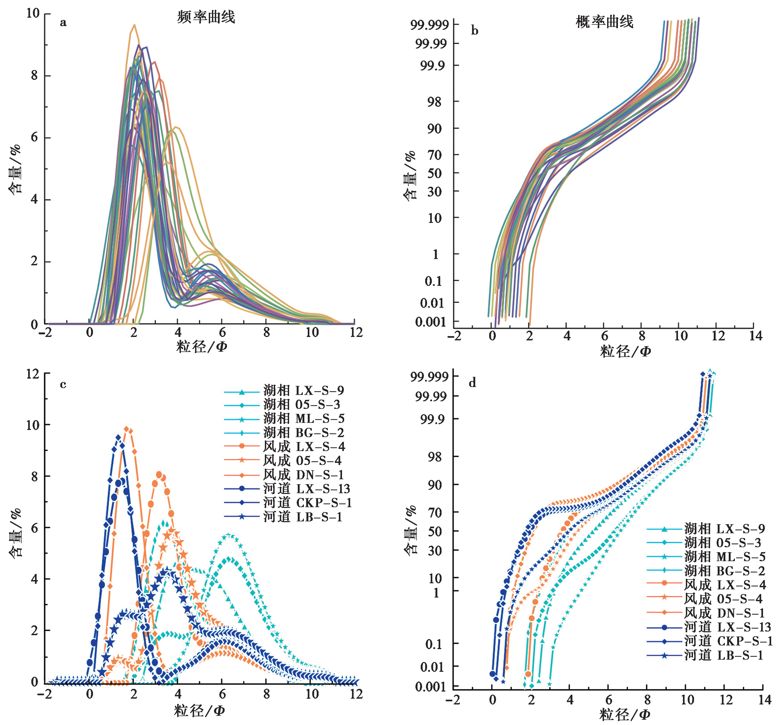
图3 粒度样品的频率分布曲线与概率累计曲线 a、b分别为洪水沙的频率曲线和概率曲线; c、d分别为湖层沙、风成沙和河流沙的频率曲线和概率曲线
Fig. 3 The frequency distribution curve and probability accumulation curve of the samples.
| 样品名 | Y1 | Y2 | Y3 | Y4 | 环境 | 样品名 | Y1 | Y2 | Y3 | Y4 | 环境 |
|---|---|---|---|---|---|---|---|---|---|---|---|
| TM-S-1 | 0.185 | 232.131 | -23.383 | 11.754 | 浊流 | GM-S-2 | 5.245 | 186.924 | -14.389 | 21.422 | 浊流 |
| NQ-S-1 | 1.942 | 256.314 | -26.230 | 13.343 | 浊流 | JC-S-3 | 6.418 | 354.833 | -40.179 | 9.468 | 河流 |
| DG-S-1 | 1.945 | 324.146 | -35.515 | 8.672 | 河流 | CK-S-1 | -2.052 | 282.990 | -28.122 | 11.958 | 浊流 |
| LX-S-1 | 5.392 | 337.911 | -38.298 | 10.166 | 浊流 | LX-S-3 | 8.789 | 400.733 | -47.709 | 8.443 | 河流 |
| LX-S-7 | -2.564 | 286.384 | -28.544 | 10.771 | 浊流 | LX-S-11 | 5.688 | 317.065 | -35.826 | 11.442 | 浊流 |
| WR-S-1 | -0.243 | 205.775 | -19.271 | 13.130 | 浊流 | GJ-S-1 | 1.843 | 224.526 | -22.454 | 14.258 | 浊流 |
| ZC-S-1 | 1.029 | 271.474 | -29.312 | 9.754 | 河流 | CKP-S-2 | 2.336 | 326.089 | -35.794 | 8.440 | 河流 |
| BZ-S-1 | -2.438 | 203.035 | -17.488 | 13.106 | 浊流 | LL-S-1 | 1.342 | 254.469 | -26.189 | 13.167 | 浊流 |
| LLN-S-3 | 1.342 | 254.469 | -26.189 | 13.167 | 浊流 | ZR-S-1 | 1.951 | 289.622 | -32.373 | 9.980 | 浊流 |
| MLD-S-2 | 2.880 | 241.458 | -24.602 | 13.412 | 浊流 | JCN-S-1 | -0.233 | 262.300 | -26.595 | 11.405 | 浊流 |
| ML-S-1 | -0.678 | 213.953 | -19.971 | 13.479 | 浊流 | MR-S-1 | 3.415 | 229.089 | -22.310 | 15.913 | 河流 |
| BG-S-2 | 0.025 | 285.931 | -28.392 | 10.114 | 浊流 | DN-S-1 | 7.292 | 321.464 | -35.278 | 15.513 | 浊流 |
表2 沉积环境结果
Table2 Sedimentary environment
| 样品名 | Y1 | Y2 | Y3 | Y4 | 环境 | 样品名 | Y1 | Y2 | Y3 | Y4 | 环境 |
|---|---|---|---|---|---|---|---|---|---|---|---|
| TM-S-1 | 0.185 | 232.131 | -23.383 | 11.754 | 浊流 | GM-S-2 | 5.245 | 186.924 | -14.389 | 21.422 | 浊流 |
| NQ-S-1 | 1.942 | 256.314 | -26.230 | 13.343 | 浊流 | JC-S-3 | 6.418 | 354.833 | -40.179 | 9.468 | 河流 |
| DG-S-1 | 1.945 | 324.146 | -35.515 | 8.672 | 河流 | CK-S-1 | -2.052 | 282.990 | -28.122 | 11.958 | 浊流 |
| LX-S-1 | 5.392 | 337.911 | -38.298 | 10.166 | 浊流 | LX-S-3 | 8.789 | 400.733 | -47.709 | 8.443 | 河流 |
| LX-S-7 | -2.564 | 286.384 | -28.544 | 10.771 | 浊流 | LX-S-11 | 5.688 | 317.065 | -35.826 | 11.442 | 浊流 |
| WR-S-1 | -0.243 | 205.775 | -19.271 | 13.130 | 浊流 | GJ-S-1 | 1.843 | 224.526 | -22.454 | 14.258 | 浊流 |
| ZC-S-1 | 1.029 | 271.474 | -29.312 | 9.754 | 河流 | CKP-S-2 | 2.336 | 326.089 | -35.794 | 8.440 | 河流 |
| BZ-S-1 | -2.438 | 203.035 | -17.488 | 13.106 | 浊流 | LL-S-1 | 1.342 | 254.469 | -26.189 | 13.167 | 浊流 |
| LLN-S-3 | 1.342 | 254.469 | -26.189 | 13.167 | 浊流 | ZR-S-1 | 1.951 | 289.622 | -32.373 | 9.980 | 浊流 |
| MLD-S-2 | 2.880 | 241.458 | -24.602 | 13.412 | 浊流 | JCN-S-1 | -0.233 | 262.300 | -26.595 | 11.405 | 浊流 |
| ML-S-1 | -0.678 | 213.953 | -19.971 | 13.479 | 浊流 | MR-S-1 | 3.415 | 229.089 | -22.310 | 15.913 | 河流 |
| BG-S-2 | 0.025 | 285.931 | -28.392 | 10.114 | 浊流 | DN-S-1 | 7.292 | 321.464 | -35.278 | 15.513 | 浊流 |
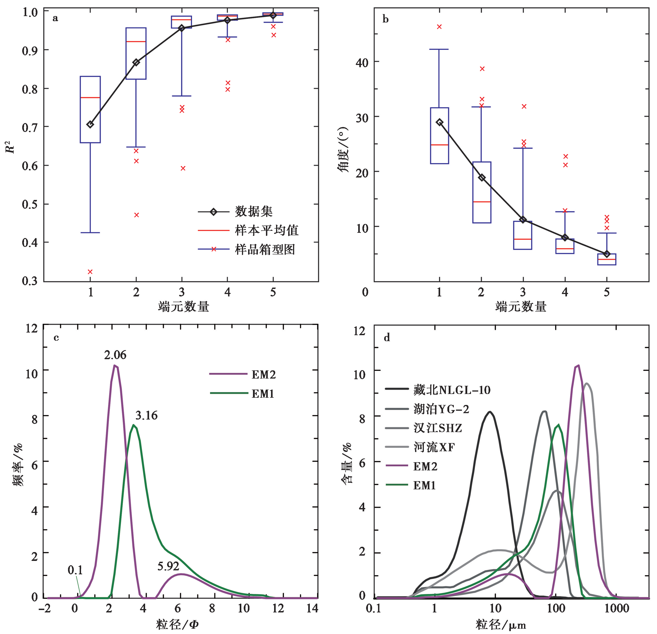
图4 雅鲁藏布江洪水沉积物粒度数据的端元分析结果 a 洪水沙端元数的复相关性; b 洪水沙粒度拟合端元数的角平均值; c 洪水沙拟合的2个端元粒度频率分布曲线; d 不同环境沉积物的粒度频率分布曲线对比
Fig. 4 End member analysis results of the grain size data of flood deposits.

图7 雅鲁藏布江中游洪水沙及丹娘沙丘石英颗粒的扫描电镜(SEM)图像 a 棱角状石英颗粒, 发育溶蚀孔洞, DG-S-2, 采样地为陇兰乡东; b 次棱角状石英颗粒, 发育贝壳状断口, CK-S-2, 采样地为冲康村; c 次棱角状石英颗粒, 发育上翻解理片, CK-S-2, 采样地为冲康村; d 次棱角状石英颗粒, 发育擦痕、解理台阶, TM-S-1, 采样地为诺米村; e 棱角状石英颗粒, 发育擦痕、贝壳状断口、“V”形坑, DN-S-1, 采样地为丹娘沙丘; f 棱角状石英颗粒, 发育擦痕、贝壳状断口, 可见溶蚀孔洞, DN-S-1, 采样地为丹娘沙丘
Fig. 7 Scanning electron microscope images of quartz grain surfaces.
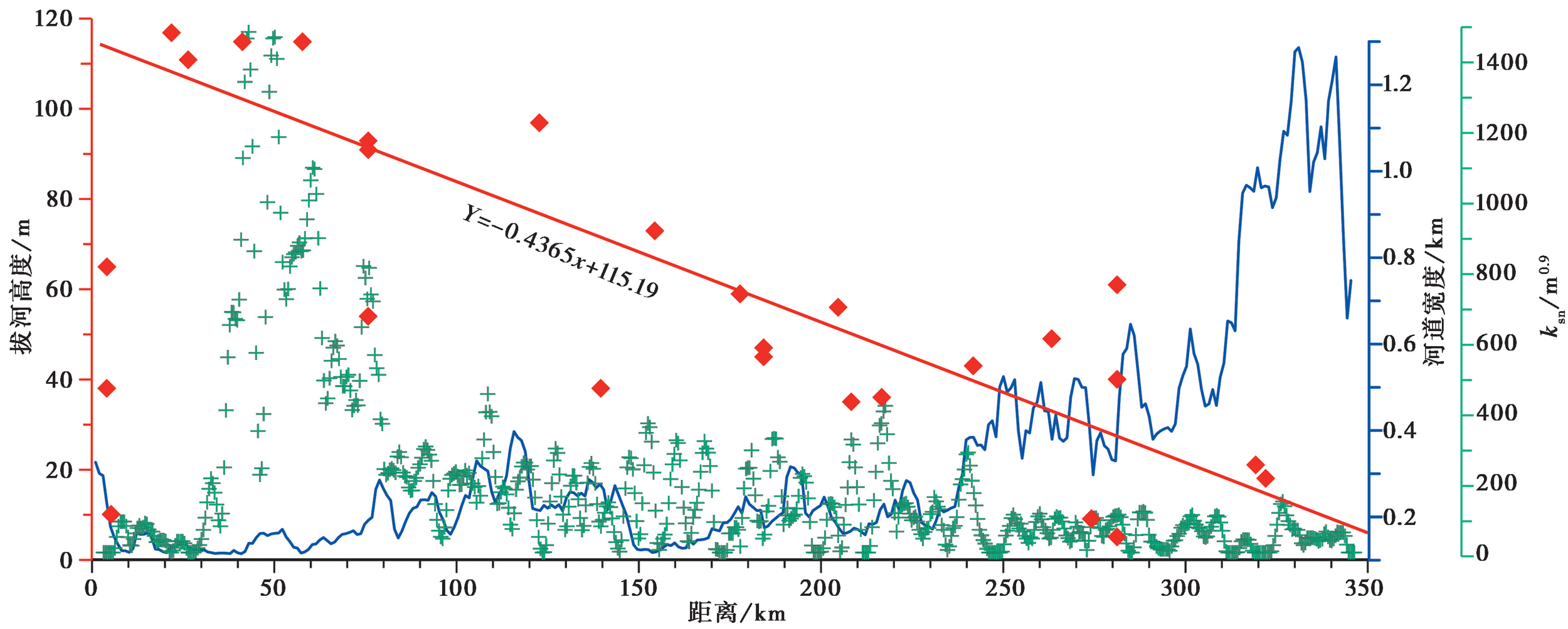
图5 雅鲁藏布江加查-派镇段的河流纵剖面特征图
Fig. 5 Longitudinal profile of the main stream of Yarlung Tsangpo River.
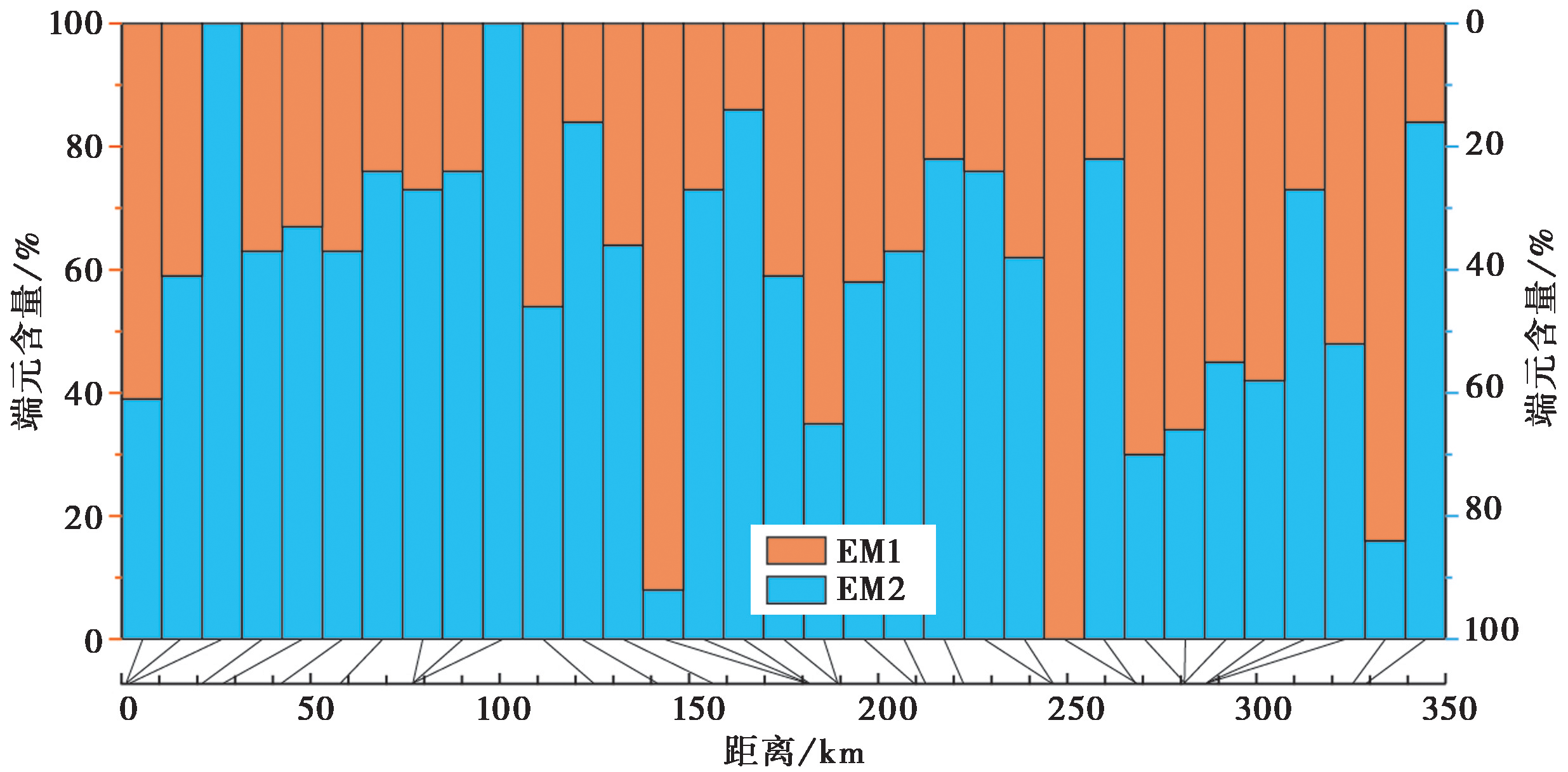
图6 雅鲁藏布江洪水沙粒度组分的端元含量
Fig. 6 End-member content for megaflood sand of Yarlung Tsangpo River.
| [1] |
郭永强, 黄春长, 庞奖励, 等. 2014. 汉江上游现代大洪水滞流沉积物的粒度分布特征研究[J]. 地理科学, 34(11): 1369-1376.
DOI |
|
GUO Yong-qiang, HUANG Chun-chang, PANG Jiang-li, et al. 2014. Grain size characteristics of modern flood slackwater deposits along the upper Hanjiang River[J]. Scientia Geographica Sinica, 34(11): 1369-1376. (in Chinese)
DOI |
|
| [2] | 江新胜, 徐金沙, 潘忠习. 2003. 鄂尔多斯盆地白垩纪沙漠石英沙颗粒表面特征[J]. 沉积学报, 21(3): 416-422. |
| JIANG Xin-sheng, XU Jin-sha, PAN Zhong-xi. 2003. Microscopic features on quartz sand grain surface in the Cretaceous desert of Ordos Basin[J]. Acta Sedimentologica Sinica, 21(3): 416-422. (in Chinese) | |
| [3] | 李长安, 张玉芬, 袁胜元, 等. 2009. 江汉平原洪水沉积物的粒度特征及环境意义: 以2005年汉江大洪水为例[J]. 第四纪研究, 29(2): 276-281. |
| LI Chang-an, ZHANG Yu-fang, YUAN Sheng-yuan, et al. 2009. Grain size characteristics and environmental significance of Hanjiang 2005 flood sediments[J]. Quaternary Sciences, 29(2): 276-281. (in Chinese) | |
| [4] | 刘东生. 1985. 黄土与环境[M]. 北京科学出版社. |
| LIU Dong-sheng. 1985. Loess and Environment[M]. Science Press, Beijing. (in Chinese) | |
| [5] | 潘美慧, 杨安娜, 伍永秋, 等. 2020. 雅江河谷佛掌沙丘表层沉积物粒度特征[J]. 自然资源学报, 35(12): 3076-3088. |
| PAN Mei-hui, YANG An-na, WU Yong-qiu, et al. 2020. Variation of grain sizes for surface sediments of Fozhang dune in Yarlung Zangbo River valley[J]. Journal of Nature Resources, 35(12): 3076-3088. (in Chinese) | |
| [6] | 孙东怀, 安芷生, 苏瑞侠, 等. 2001. 古环境中沉积物粒度组分分离的数学方法及其应用[J]. 自然科学进展, 11(3): 269-276. |
| SUN Dong-huai, AN Zhi-sheng, SU Rui-xia, et al. 2001. A mathematical method for the separation of grain size components of sediments in paleo-environment and its application[J]. Progress in Natural Science, 11(3): 269-276. (in Chinese) | |
| [7] | 田明中. 2009. 第四纪地质学与地貌学[M]. 北京: 地质出版社. |
| TIAN Ming-zhong. 2009. Quaternary Geology and Geomorphology[M]. Geological Publishing House, Beijing. (in Chinese) | |
| [8] | 王二七, 陈良忠, 陈智樑. 2002. 在构造和气候因素制约下的雅鲁藏布江的演化[J]. 第四纪研究, 22(4): 365-373. |
| WANG Er-qi, CHEN Liang-zhong, CHEN Zhi-liang. 2002. Tectonic and climatic element-controlled evolution of the Yarlung Zangbo River in southern Tibet[J]. Quaternary Sciences, 22(4): 365-373. (in Chinese) | |
| [9] |
王昊, 崔鹏, Paul A C. 2021. 高能洪水沉积研究综述[J]. 地学前缘, 28(2): 140-167.
DOI |
|
WANG Hao, CUI Peng, Paul A C. 2021. The sedimentology of high-energy outburst floods deposit: An overview[J]. Earth Science Frontiers, 28(2): 140-167. (in Chinese)
DOI |
|
| [10] | 王伟, 李安春, 徐方建, 等. 2009. 北黄海表层沉积物粒度分布特征及其沉积环境分析[J]. 海洋与湖沼, 40(5): 525-531. |
| WANG Wei, LI An-chun, XU Fang-jian, et al. 2009. Distribution of surface sediments and sedimentary environment in the North Yellow Sea[J]. Oceanologia et Limnologia Sinica, 40(5): 525-531. (in Chinese) | |
| [11] |
王勇, 韩广, 杨林, 等. 2017. 响水河中游右岸沙丘群粒度分布特征[J]. 中国沙漠, 37(1): 26-32.
DOI |
|
WANG Yong, HAN Guang, YANG Lin, et al. 2017. Grain size characteristics of sand dunes on the right bank of the middle Xiangshui River[J]. Journal of Desert Research, 37(1): 26-32. (in Chinese)
DOI |
|
| [12] | 吴庆隆. 2019. 金沙江、雅鲁藏布江发现史前巨大洪水事件[J]. 南京师大学报(自然科学版), 42(3): 163-164. |
| WU Qing-long. 2019. Giant prehistoric flood events were found in the Jinsha and Brahmaputra Rivers[J]. Journal of Nanjing Normal University(Natural Science Edition), 42(3): 163-164. (in Chinese) | |
| [13] | 杨晓燕, 夏正楷, 崔之久. 2005. 黄河上游全新世特大洪水及其沉积特征[J]. 第四纪研究, 25(1): 80-85. |
| YANG Xiao-yan, XIA Zheng-kai, CUI Zhi-jiu. 2005. Holocene extreme floods and its sedimentary characteristic in the upper reaches of the Yellow River[J]. Quaternary Sciences, 21(1): 80-85. (in Chinese) | |
| [14] | 杨晓云. 2015. 青藏高原北部那陵格勒河流域现代洪水过程和古洪水沉积物光释光年代学及粒度特征[D]. 青海: 青海师范大学. |
| YANG Xiao-yun. 2015. Modern flood process and the OSL dating and grain-size characteristic on palaeoflood deposits of Nalinggele Watershed, northern of the Qinghai-Tibet Plateau[D]. Qinghai Normal University, Qinghai. (in Chinese) | |
| [15] | 殷志强, 秦小光, 吴金水, 等. 2008. 湖泊沉积物粒度多组分特征及其成因机制研究[J]. 第四纪研究, 28(2): 161-169. |
| YIN Zhi-qiang, QIN Xiao-guang, WU Jin-shui, et al. 2008. Multimodal grain-size distribution characteristics and formation mechanism of lake sediments[J]. Quaternary Sciences, 28(2): 161-169. (in Chinese) | |
| [16] | 钟宁, 蒋汉朝, 李海兵, 等. 2020. 岷江上游新磨村湖相沉积物粒度端元反演及其记录的构造和气候事件[J]. 地质学报, 94(3): 968-981.<br |
| ZHONG Ning, JIANG Han-chao, LI Hai-bing, et al. 2020. End member inversion of Xinmocun lacustrine sediments in the upper reaches of the Minjiang River and its recorded tectonic and climate events[J]. Acta Geologica Sinica, 94(3): 968-981. (in Chinese) | |
| [17] |
朱诚, 于世永, 史威, 等. 1997. 南京江北地区全新世沉积与古洪水研究[J]. 地理研究, 16(4): 23-30.
DOI |
|
ZHU Cheng, YU Shi-yong, SHI Wei, et al. 1997. Holocene deposits and paleo-floods on the north bank of the Yangtze River, Nanjing area[J]. Geographical Research, 16(4): 23-30. (in Chinese)
DOI |
|
| [18] |
An Z S, Kukla G, Porter S C, et al. 1991. Late Quaternary dust flow on the Chinese Loess Plateau[J]. Catena, 18(2): 125-132.
DOI URL |
| [19] |
Ashley G M. 1978. Interpretation of polymodal sediments[J]. Journal of Geology, 86(4): 1-11.
DOI URL |
| [20] |
Bagnold R A, Barndorff O. 1980. The pattern of natural size distributions[J]. Sedimentology, 27(2): 199-207.
DOI URL |
| [21] | Baker V R. 1987. Paleoflood hydrology and extraordinary flood events[J]. Journal of Hydrology, 96(1-4): 79-99. |
| [22] | Baker V R. 2020. Global megaflood paleohydrology [G]∥Herget J, Fontana A(eds). Palaeohydrology: Traces, Tracks and Trails of Extreme Events. Cham: Springer: 3-28. |
| [23] |
Bianchi G G, Mccave I N. 1999. Holocene periodicity in North Atlantic climate and deep-ocean flow south of Iceland[J]. Nature, 397(6719): 515-517.
DOI URL |
| [24] |
Borgohain B, Mathew G, Chauhan N, et al. 2020. Evidence of episodically accelerated denudation on the Namche Barwa massif(eastern Himalayan syntaxis)by megafloods[J]. Quaternary Science Reviews, 245(362): 106410.
DOI URL |
| [25] |
Bretz J H. 1923. The channeled scablands of the Columbia plateau[J]. The Journal of Geology, 31(8): 617-649.
DOI URL |
| [26] |
Broecker W S, Kemmett J P, Flower B P, et al. 1989. Routing of meltwater from the Laurentide Ice Sheet during the Younger Dryas cold episode[J]. Nature, 341(1): 318-321.
DOI |
| [27] |
Carling P A. 2013. Freshwater megaflood sedimentation: What can we learn about generic processes?[J]. Earth-Science Reviews, 125(1): 87-113.
DOI URL |
| [28] |
Celina C. 1998. Late Holocene lake sedimentology and climate change in southern Alberta, Canada[J]. Quaternary Research, 49(1): 96-101.
DOI URL |
| [29] |
Ding Z L, Yu Z W, Rutter N W, et al. 1994. Towards an orbital time scale for Chinese loess deposits[J]. Quaternary Science Reviews, 13(1): 39-70.
DOI URL |
| [30] | Egli R. 2003. Analysis of the field dependence of remanent magnetization curves[J]. Journal of Geophysical Research: Solid Earth, 108(B2): 1-25. |
| [31] |
Fan J W, Jiang H C, Shi W, et al. 2020. A 450-year lacustrine record of recurrent seismic activities around the Fuyun Fault, Altay Mountains, Northwest China[J]. Quaternary International, 558(1): 75-88.
DOI URL |
| [32] |
Folk R L. 1966. A review of grain size parameters[J]. Sedimentology, 6(2): 73-93.
DOI URL |
| [33] |
Folk R L, Ward W C. 1957. Brazos River bar, a study in the significance of grain-size parameters[J]. Journal of Sedimentary Petrology, 27(1): 3-26.
DOI URL |
| [34] |
Gupta S, Collier J S, Palmerfelgate A, et al. 2007. Catastrophic flooding origin of shelf valley systems in the English channel[J]. Nature, 448(7151): 342-345.
DOI |
| [35] |
Korup O, Montgomery D R. 2008. Tibetan plateau river incision inhibited by glacial stabilization of the Tsangpo gorge[J]. Nature, 455(7214): 786-789.
DOI |
| [36] | Korup O, Tweed F. 2007. Ice, moraine, and landslide dams in mountainous terrain[J]. Quaternary Science Reviews, 26(25-28): 3406-3422. |
| [37] |
Kranck K, Smith P C, Milligan T G. 1996. Grain-size characteristics of fine-grained unflocculated sediments Ⅱ: ‘Multi-round’ distributions[J]. Sedimentology, 43(3): 597-606.
DOI URL |
| [38] |
Lang K A, Huntington K W, Montgomery D R. 2013. Erosion of the Tsangpo Gorge by megafloods, Eastern Himalaya[J]. Geology, 41(9): 1003-1006.
DOI URL |
| [39] |
Liu W, Carling P A, Hu K, et al. 2019. Outburst floods in China: A review[J]. Earth-Science Reviews, 197:102895.
DOI URL |
| [40] |
Mahaney W C, Kalm V. 2000. Comparative scanning electron microscopy study of oriented tillblocks, glacial grains and Devonian sands in Estonia and Latvia[J]. Boreas, 29(1): 35-51.
DOI URL |
| [41] |
Middleton G V. 1976. Hydraulic interpretation of sand size distribution[J]. Journal of Geology, 84(4): 405-426.
DOI URL |
| [42] |
Montgomery D R, Hallet B, Yuping L, et al. 2004. Evidence for Holocene megafloods down the Tsangpo River gorge, southeastern Tibet[J]. Quaternary Research, 62(2): 201-207.
DOI URL |
| [43] |
Paterson G A, Heslop D. 2015. New methods for unmixing sediment grain size data[J]. Geochemistry, Geophysics, Geosystems, 16(12): 4494-4506.
DOI URL |
| [44] |
Rea D K. 1994. The paleoclimatic record provided by eolian deposition in the deep sea: The geologic history of wind[J]. Reviews of Geophysics, 32(2): 159-195.
DOI URL |
| [45] | Rea D K, Hovan S A. 1995. Grain size distribution and depositional processes of the mineral component of abyssal sediments: Lessons from the North Pacific[J]. Paleoceanography and Paleoclimatology, 10(2): 251-258. |
| [46] | Sahu B K. 1964. Depositional mechanisms from the size analysis of clastic sediments[J]. Journal of Sedimentary Research, 34(1): 73-83. |
| [47] |
Srivastava P, Kumar A, Chaudary S, et al. 2017. Paleofloods records in Himalaya[J]. Geomorphology, 284(5-1): 17-30.
DOI URL |
| [48] |
Sun D H, Jan B, Rea D K, et al. 2004. Bimodal grain-size distribution of Chinese loess, and its palaeoclimatic implications[J]. Catena, 55(3): 325-340.
DOI URL |
| [49] |
Turzewski M D, Huntington K W, Leveque R J. 2019. The geomorphic impact of outburst floods: Integrating observations and numerical simulations of the 2000 Yigong flood, eastern Himalaya[J]. Journal of Geophysical Research: Earth Surface, 124(5): 1056-1079.
DOI URL |
| [50] | Visher G S. 1969. Gain size distribution and depositional processes[J]. Journal of Sedimentary Research, 39(3): 1074-1106. |
| [51] | Weltje G J. 1997. End-member modeling of composition data: Numerical-statistical algorithms for solving the explicit mixing problem[J]. Journal of Mathematical Geology, 29(4): 503-549. |
| [52] | Xiao J L, Zheng H B, Zhao H. 1992. Variation of winter monsoon intensity on the Loess Plateau, central China during the last 130, 000 years: Evidence from grain size distribution[J]. Quaternary Research, 31(1): 13-19. |
| [53] |
Yang A, Wang H, Liu W, et al. 2022. Two megafloods in the middle reach of Yarlung Tsangpo River since Last-glacial period: Evidence from giant bars[J]. Global and Planetary Change, 208:103726. https://doi.org/10.1016/j.gloplacha.2021.103726.
DOI URL |
| [54] |
Zhou N, Zhang C L, Wu X X, et al. 2014. The geomorphology and evolution of aeolian landforms within a river valley in a semi-humid environment: A case study from Mainling Valley, Qinghai-Tibet Plateau[J]. Geomorphology, 224(1): 27-38.
DOI URL |
| [1] | 李彦宝, 陈立春, 王虎, 曾蒂, 刘成龙. 雅鲁藏布江断裂带昂仁段晚第四纪活动证据[J]. 地震地质, 2019, 41(5): 1091-1104. |
| [2] | 李翠平, 王萍, 钱达, 唐茂云. 雅鲁藏布江大峡谷入口河段最近两期古堰塞湖事件的年龄[J]. 地震地质, 2015, 37(4): 1136-1146. |
| [3] | 刘强, 魏海泉, 许建东, 栾鹏, 孙春强, 潘波, 赵波, 于红梅. 吉林龙岗四海火山碎屑物粒度分析与地质意义[J]. 地震地质, 2009, 31(1): 112-121. |
| [4] | 杨清福, 史兰斌, 张羽, 陈波, 陈孝德. 长白山天池火山千年大喷发火山碎屑流堆积的粒度特征与地质意义[J]. 地震地质, 2007, 29(3): 480-491. |
| [5] | 叶先仁, 吴茂炳, 陶明信, 张铭杰. 西藏日喀则地区蛇绿岩的氦同位素研究[J]. 地震地质, 2003, 25(s1): 62-70. |
| 阅读次数 | ||||||
|
全文 |
|
|||||
|
摘要 |
|
|||||
