地震地质 ›› 2023, Vol. 45 ›› Issue (3): 652-667.DOI: 10.3969/j.issn.0253-4967.2023.03.004
刘伟1)( ), 白细民2), 吕少杰1), 史浙明1),*(), 齐之钰1), 何冠儒1)
收稿日期:2022-11-07
修回日期:2023-03-15
出版日期:2023-06-20
发布日期:2023-07-18
通讯作者:
* 史浙明, 男, 1988年生, 教授, 主要从事地下水方面的研究, E-mail: 作者简介:刘伟, 男, 1998年生, 现为中国地质大学(北京)地质学专业在读硕士研究生, 主要从事地下水对气压和固体潮的响应研究, E-mail: 1635474420@qq.com。
基金资助:
LIU Wei1)(), BAI Xi-min2), LÜ Shao-jie1), SHI Zhe-ming1),*(), QI Zhi-yu1), HE Guan-ru1)
Received:2022-11-07
Revised:2023-03-15
Online:2023-06-20
Published:2023-07-18
摘要:
研究井水位对气压信号的响应可揭示地下水运动规律、 含水层储水机制等众多水文地质信息, 也可为求解含水层的水力参数提供新的途径。相较于传统野外水文地质试验, 利用井水位气压响应求解参数的方法具有原位、 低成本、 低扰动的优势。文中以位于曲江断裂带的高大井为研究对象, 基于不同时间段内井水位对气压信号的响应, 计算了含水层的水力参数。结果表明: 不同观测时段内高大井所在含水层的渗透率为8.89×10⁻¹⁵~11.10×10⁻¹⁵m2, 导水系数为2.44×10⁻⁶~3.05×10⁻⁶m2/s, 总体变化不大, 说明地震后高大井含水层的渗透性并未发生显著改变, 曲江断裂带的渗透性相对比较稳定。利用气压响应方法计算的结果与前人利用固体潮响应和微水试验计算所得结果存在一定差异, 反映了利用不同井-含水层系统的响应模型反演的含水层水力参数所代表的空间尺度、 模型的适用性及参数范围的差异性。由于气压信号作用的频段更宽, 模型反演的参数更多, 且在不同水文地质条件下均能记录其响应, 使得气压响应模型的适用性更为广泛。
刘伟, 白细民, 吕少杰, 史浙明, 齐之钰, 何冠儒. 基于井水位气压效应计算含水层的水力参数[J]. 地震地质, 2023, 45(3): 652-667.
LIU Wei, BAI Xi-min, LÜ Shao-jie, SHI Zhe-ming, QI Zhi-yu, HE Guan-ru. HYDROLOGICAL PROPERTIES ESTIMATION BY WATER LEVEL IN RESPONSE TO BAROMETRIC PRESSURE[J]. SEISMOLOGY AND GEOLOGY, 2023, 45(3): 652-667.

图 1 高大井的位置及其周边的地质构造图
Fig. 1 Location of the Gaoda well and surrounding geological structures.
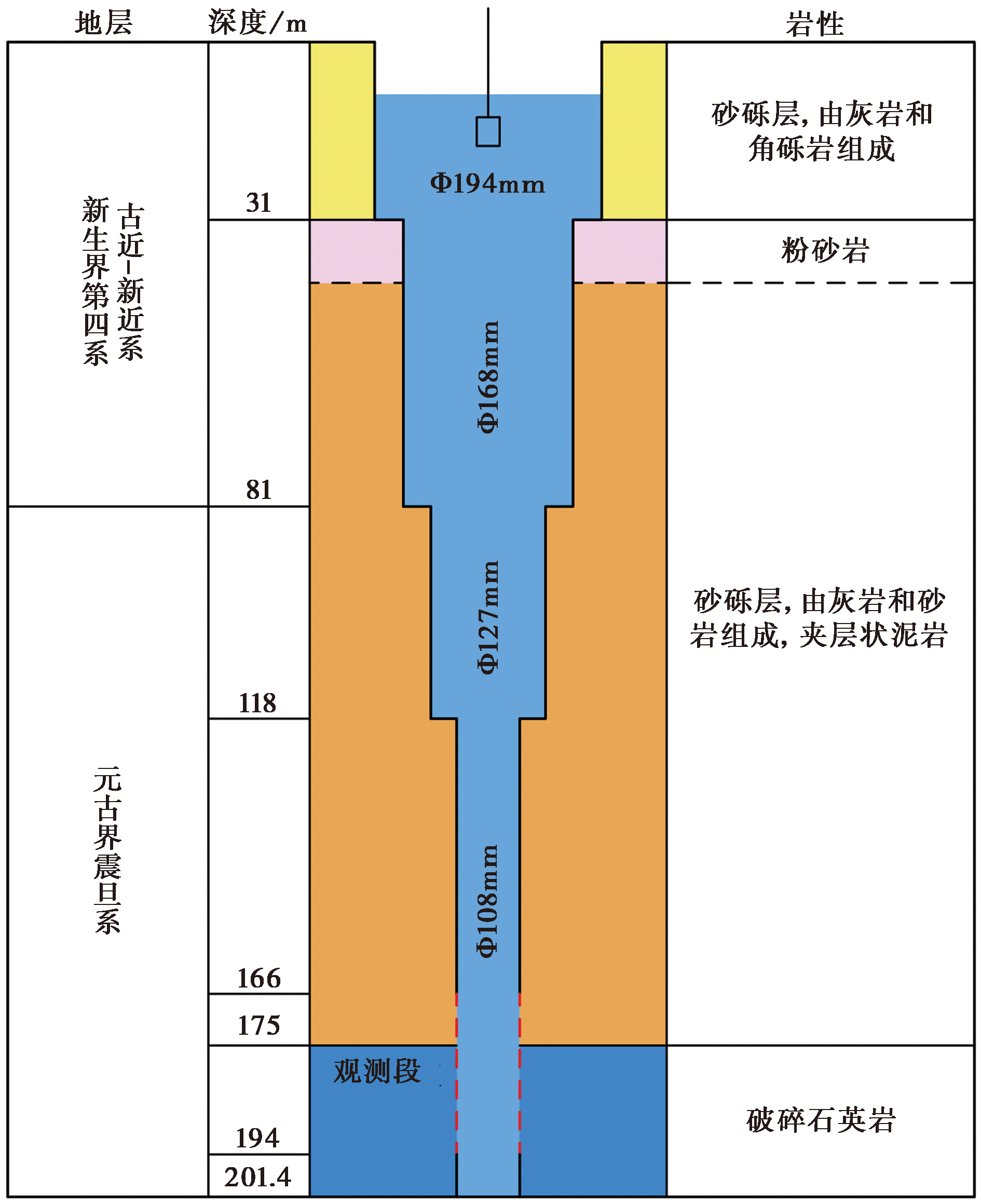
图 2 高大井的岩性及钻孔剖面示意图(改自张体移等, 2012; Ma et al., 2019)
Fig. 2 Lithology and wellbore structure of the Gaoda well(adapted from ZHANG Ti-yi et al., 2012; Ma et al., 2019).
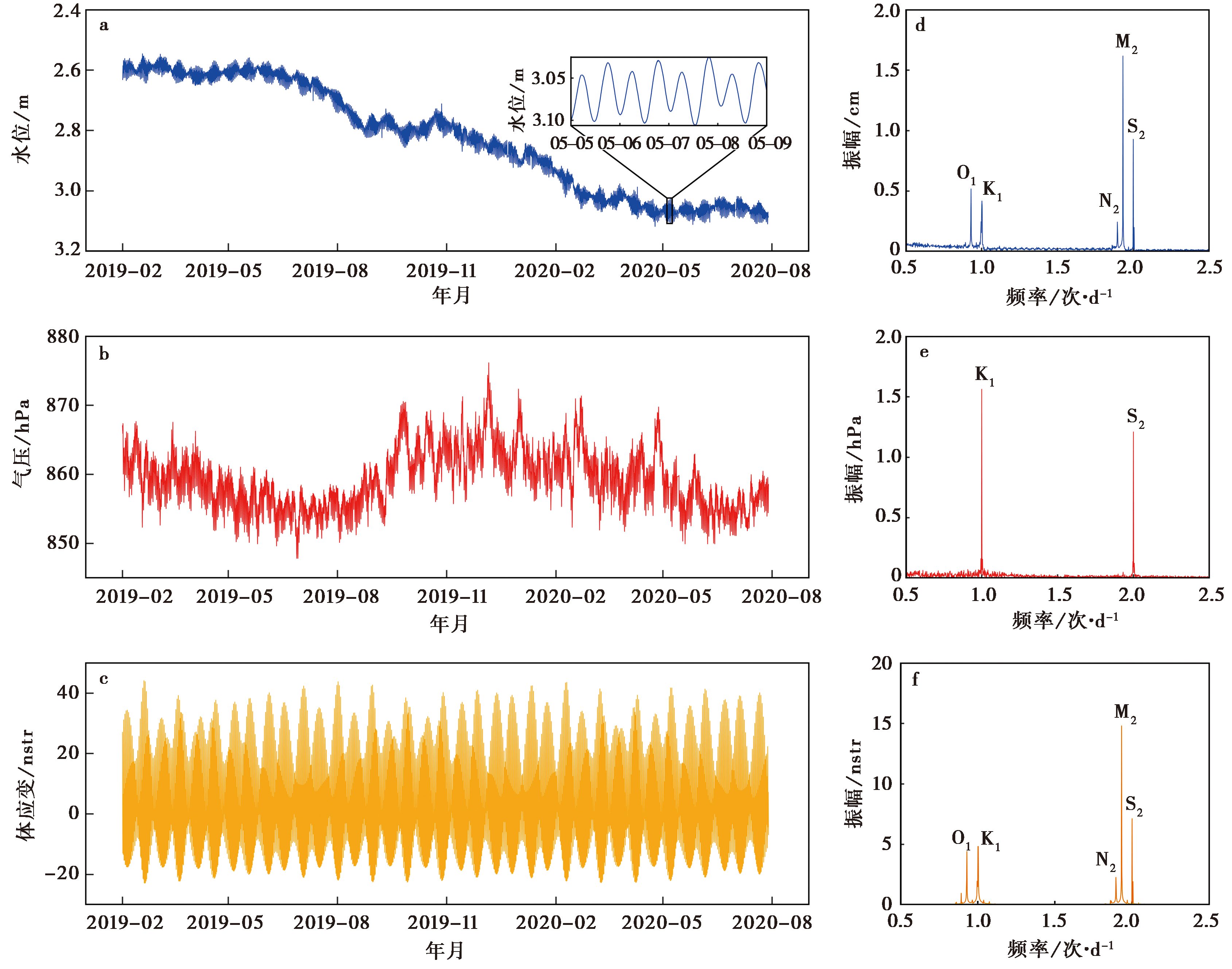
图 3 2019年2月—2020年7月高大井的水位、 气压和体应变时间序列及频谱分析图 a 水位; b 气压; c 体应变; d 水位振幅谱; e 气压振幅谱; f 体应变振幅谱
Fig. 3 Time series and spectral analysis plot of water level, barometric pressure, and volume strain in Gaoda well from February 2019 to July 2020.
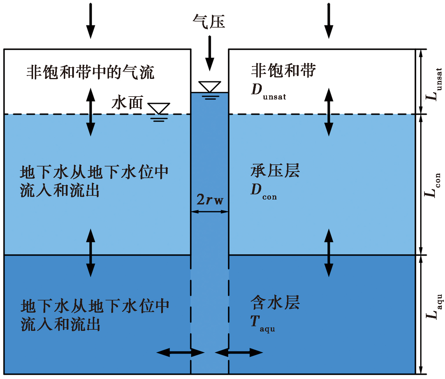
图 4 理想开放井-含水层系统对气压的响应示意图 (改自Rojstaczer, 1988; Hussein et al., 2013; Odling et al., 2015)
Fig. 4 Schematic of the response of an ideal open well-aquifer system to barometric pressure (adapted from Rojstaczer, 1988; Hussein et al., 2013; Odling et al., 2015).
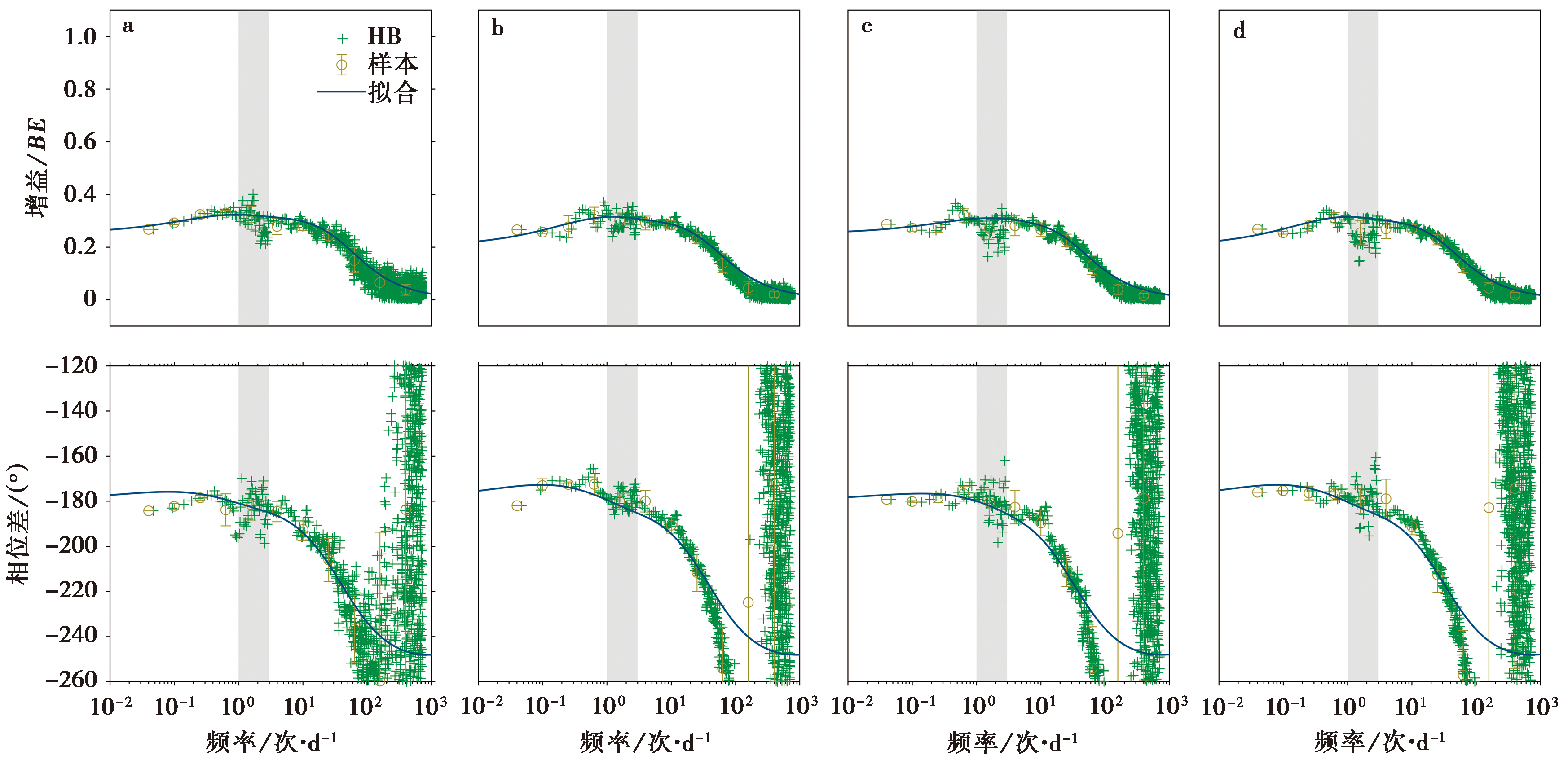
图 5 不同数据长度下高大井增益(Gain)和相位滞后(Phase)拟合曲线 a 数据长度为30d; b 数据长度为180d; c数据长度为1a; d 数据长度为1.5a。灰色段代表固体潮频段
Fig. 5 Gain and Phase lag fitting curves for different data lengths in Gaoda well.
| 数据长度 | Q/W | ( /2Dcon)/d | ( /Taqu)/d | BE | Tcf |
|---|---|---|---|---|---|
| 30d | 483.1087 | 5.3530 | 0.01108 | 0.32 | 0.75 |
| 180d | 344.1701 | 3.9793 | 0.01156 | 0.31 | 0.8 |
| 1a | 189.9513 | 2.5683 | 0.01352 | 0.31 | 0.75 |
| 1.5a | 339.0560 | 4.6928 | 0.01384 | 0.31 | 0.8 |
表 1 不同数据长度下高大井的拟合参数
Table 1 Fitting parameters of the Gaoda well with different data lengths
| 数据长度 | Q/W | ( /2Dcon)/d | ( /Taqu)/d | BE | Tcf |
|---|---|---|---|---|---|
| 30d | 483.1087 | 5.3530 | 0.01108 | 0.32 | 0.75 |
| 180d | 344.1701 | 3.9793 | 0.01156 | 0.31 | 0.8 |
| 1a | 189.9513 | 2.5683 | 0.01352 | 0.31 | 0.75 |
| 1.5a | 339.0560 | 4.6928 | 0.01384 | 0.31 | 0.8 |
| 数据长度 | σcon/s-1 | k/m2 | Taqu/m2·s-1 |
|---|---|---|---|
| 30d | 1.08×10⁻¹⁰ | 11.10×10⁻¹⁵ | 3.05×10⁻⁶ |
| 180d | 1.45×10⁻¹⁰ | 10.64×10⁻¹⁵ | 2.92×10⁻⁶ |
| 1a | 2.25×10⁻¹⁰ | 9.10×10⁻¹⁵ | 2.50×10⁻⁶ |
| 1.5a | 1.23×10⁻¹⁰ | 8.89×10⁻¹⁵ | 2.44×10⁻⁶ |
表 2 不同数据长度下高大井的越流系数、 渗透率和导水系数
Table 2 Leakage coefficient, permeability and transmissivity of the Gaoda well with different data lengths
| 数据长度 | σcon/s-1 | k/m2 | Taqu/m2·s-1 |
|---|---|---|---|
| 30d | 1.08×10⁻¹⁰ | 11.10×10⁻¹⁵ | 3.05×10⁻⁶ |
| 180d | 1.45×10⁻¹⁰ | 10.64×10⁻¹⁵ | 2.92×10⁻⁶ |
| 1a | 2.25×10⁻¹⁰ | 9.10×10⁻¹⁵ | 2.50×10⁻⁶ |
| 1.5a | 1.23×10⁻¹⁰ | 8.89×10⁻¹⁵ | 2.44×10⁻⁶ |
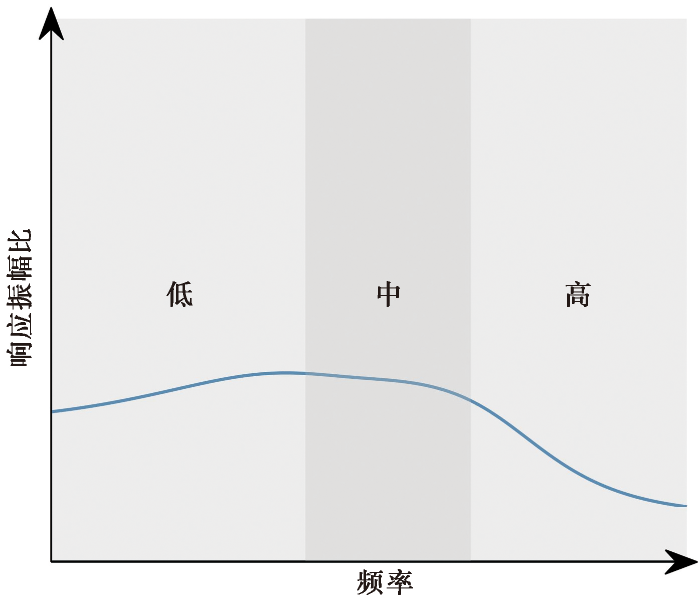
图 6 响应振幅比(增益)和频率之间的关系
Fig. 6 Relation between response amplitude ratio(Gain)and frequency.
| 试验方法 | σcon/s-1 | k/m2 | Taqu/m2·s-1 |
|---|---|---|---|
| 气压 | 1.67×10⁻¹⁰ | 1.00×10⁻¹⁴ | 2.75×10⁻⁶ |
| 固体潮 | 4.00×10⁻¹⁴ | 1.10×10⁻⁵ | |
| 微水试验 | 6.93×10⁻¹⁴ | 1.90×10⁻⁵ |
表 3 3种不同方法计算的高大井越流系数、 渗透率和导水系数(数据来源于Ma et al., 2019)
Table 3 Leakage coefficient, permeability, and transmissivity of the Gaoda well calculated by three different methods(data from Ma et al., 2019)
| 试验方法 | σcon/s-1 | k/m2 | Taqu/m2·s-1 |
|---|---|---|---|
| 气压 | 1.67×10⁻¹⁰ | 1.00×10⁻¹⁴ | 2.75×10⁻⁶ |
| 固体潮 | 4.00×10⁻¹⁴ | 1.10×10⁻⁵ | |
| 微水试验 | 6.93×10⁻¹⁴ | 1.90×10⁻⁵ |
| [1] |
方慧娜. 2013. 利用地下水位气压效应反演汶川地震前后含水层参数的研究[D]. 北京: 中国地质大学.
|
|
|
|
| [2] |
胡小静, 付虹, 卞跃跃, 等. 2022. 云南红河地区地下流体井-含水层系统特征研究[J]. 地震研究, 45(2): 300-307.
|
|
|
|
| [3] |
胡小静, 付虹, 李琼. 2018. 滇南地区近期水位趋势上升异常机理初探[J]. 地震学报, 40(5): 620-631.
|
|
|
|
| [4] |
荆振杰, 刘风香, 张井飞, 等. 2016. 曲江断裂南东段全新世滑动速率[J]. 世界地质, 35(3): 778-784.
|
|
|
|
| [5] |
孙小龙, 刘耀炜, 付虹, 等. 2020a. 我国地震地下流体学科分析预报研究进展回顾[J]. 地震研究, 43(2): 216-231.
|
|
|
|
| [6] |
孙小龙, 向阳, 李源. 2020b. 深井水位对地震波、 固体潮和气压的水力响应--以范县井为例[J]. 地震学报, 42(6): 719-731.
|
|
|
|
| [7] |
王洋, 张波, 侯建军, 等. 2015. 曲江断裂晚第四纪活动特征及滑动速率分析[J]. 地震地质, 37(4): 1177-1192. doi: 10.3969/j.issn.0253-4967.2015.04.019.
DOI |
|
|
|
| [8] |
张卉. 2021. 井-含水层系统对周期性荷载的响应及受地震影响的研究[D]. 北京: 中国地质大学.
|
|
|
|
| [9] |
张体移, 吴富焕, 毕青, 等. 2012. 通海高大水位异常与地震分析[J]. 云南大学学报(自然科学版), 34(S2): 86-92.
|
|
|
|
| [10] |
张昭栋, 郑金涵, 张广城. 1988. 水井含水层系统与水位观测系统对固体潮与地震波的响应[J]. 地震学报, 10(2): 171-182.
|
|
|
|
| [11] |
张昭栋, 郑金涵, 张广城, 等. 1989. 承压井水位对气压动态过程的响应[J]. 地球物理学报, 32(5): 539-549.
|
|
|
|
| [12] |
DOI URL |
| [13] |
DOI URL |
| [14] |
DOI URL |
| [15] |
DOI PMID |
| [16] |
DOI URL |
| [17] |
DOI URL |
| [18] |
DOI URL |
| [19] |
DOI URL |
| [20] |
DOI URL |
| [21] |
|
| [22] |
DOI URL |
| [23] |
DOI |
| [24] |
DOI URL |
| [25] |
|
| [26] |
DOI URL |
| [27] |
DOI URL |
| [28] |
DOI URL |
| [29] |
DOI URL |
| [30] |
DOI PMID |
| [31] |
|
| [32] |
|
| [33] |
DOI URL |
| [34] |
DOI URL |
| [35] |
DOI URL |
| [36] |
DOI URL |
| [37] |
PMID |
| [38] |
DOI URL |
| [39] |
DOI URL |
| [40] |
DOI PMID |
| [41] |
DOI URL |
| [1] | 李继业, 晏锐, 张思萌, 胡澜缤, 孟令蕾, 周晨. 井水位潮汐响应与小地震调制作用的关系[J]. 地震地质, 2023, 45(3): 668-688. |
| [2] | 陈敏, 唐小勇, 郭卫英, 贺曼秋, 巩浩波, 李光科, 陈雷, 杨林, 陈凯, 谭君, 贾鸿飞. 重庆大足井水位对邻井抽水的奇异响应及其机理[J]. 地震地质, 2012, (2): 359-364. |
| [3] | 顾申宜, 张慧, 解晓静, 刘阳. 海南井水位中期和中短期异常信息的提取方法及其特征分析[J]. 地震地质, 2010, 32(4): 638-646. |
| [4] | 车用太, 鱼金子, 张大维, 孙振, 简春林, 彭贵荣. 北京平原区基岩井水位的年动态特征及其成因分析[J]. 地震地质, 1994, 16(3): 255-263. |
| [5] | 张昭栋, 郑香媛, 殷积涛, 张教样. 井水位振荡试验及其结果[J]. 地震地质, 1992, 14(2): 183-188. |
| 阅读次数 | ||||||
|
全文 |
|
|||||
|
摘要 |
|
|||||
