| [1] |
DOI
|
|
BI Hai-yun, ZHENG Wen-jun, ZENG Jiang-yuan, et al. 2017. Application of SfM photogrammetry method to the quantitative study of active tectonics[J]. Seismology and Geology, 39(4): 656-674 (in Chinese).
|
| [2] |
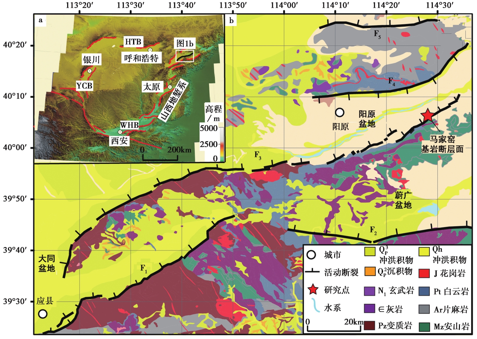
程绍平, 杨桂枝. 1996. 大同-阳原盆地南缘断裂带的晚第四纪分段和构造地貌变异[J]. 地震地质, 18(4): 289-300.
|
|
CHENG Shao-ping, YANG Gui-zhi. 1996. Late Quaternary segmentation and segmented variations in tectonic geomorphology of southern marginal fault zone of Datong-Yangyuan Basin[J]. Seismology and Geology, 18(4): 289-300 (in Chinese).
|
| [3] |
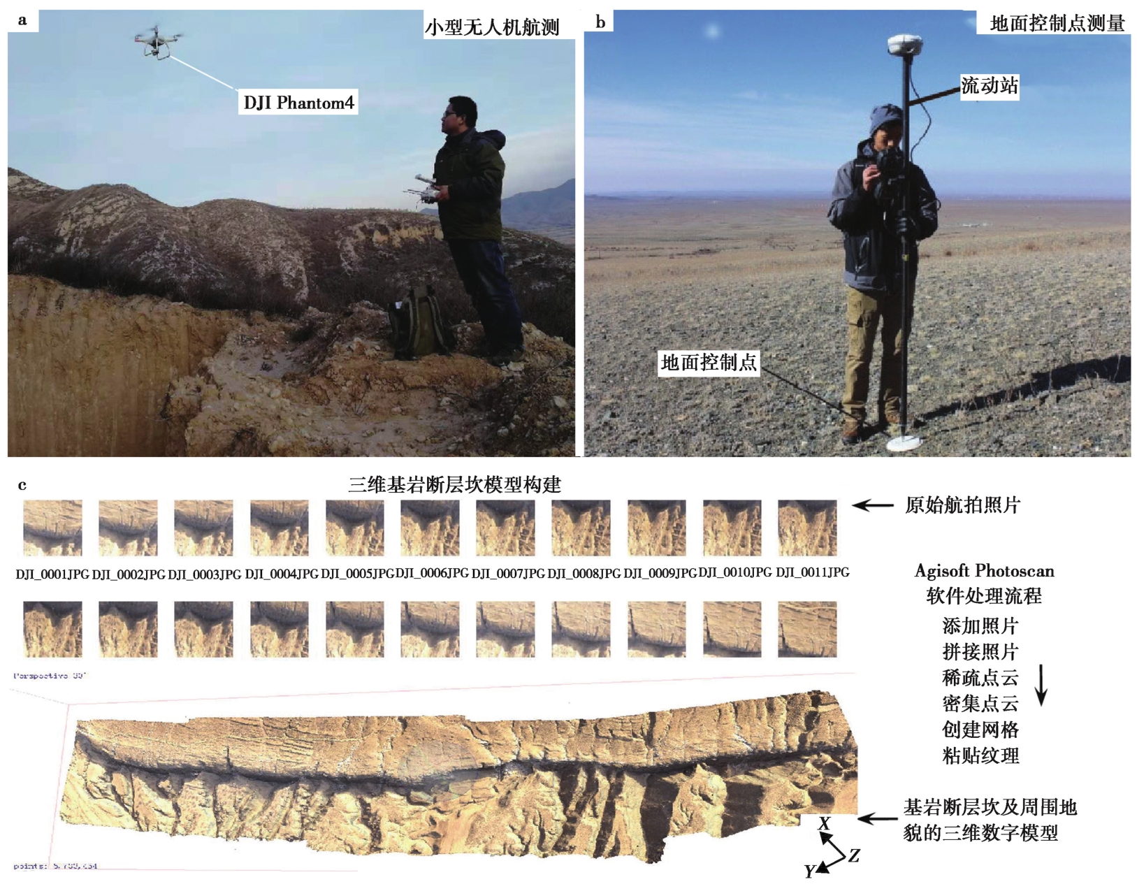
邓飞, 窦爱霞, 袁小祥. 2017. 轻小型无人机在房屋建筑结构类型调查中的应用[J]. 震灾防御技术, 12(4): 786-796.
|
|
DENG Fei, DOU Ai-xia, YUAN Xiao-xiang. 2017. Application of light-small unmanned aerial vehicle in investigating structural types of buildings[J]. Technology for Earthquake Disaster Prevention, 12(4): 786-796 (in Chinese).
|
| [4] |
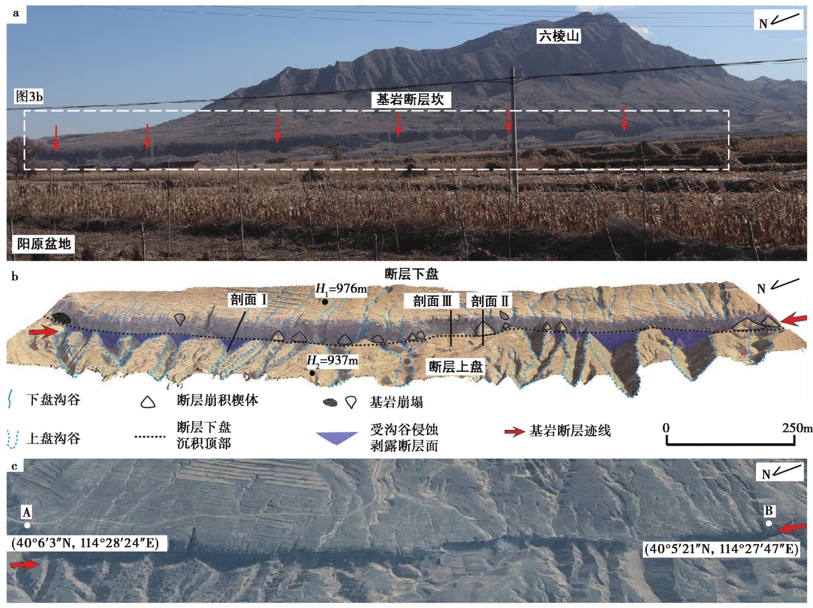
段瑞涛, 方仲景. 1995. 六棱山北麓断裂新活动特征[J]. 地震地质, 17(3): 207-213.
|
|
DUAN Rui-tao, FANG Zhong-jing. 1995. Neotectonic characteristics of the northern piedmont fault of the Liuleng Mountain[J]. Seismology and Geology, 17(3): 207-213 (in Chinese).
|
| [5] |
国家地震局“鄂尔多斯周缘断陷系活动断层研究组”. 1988. 鄂尔多斯地块周缘活动断裂系[M]. 北京: 地震出版社.
|
|
The Research Group on Active Fault System around Ordos Massif. 1988. Active Fault System around Ordos Massif[M]. Beijing: Seismological Press (in Chinese).
|
| [6] |
孙稳. 2018. 六棱山北麓断裂晚第四纪活动性[D]. 北京: 中国地震局地质研究所.
|
|
SUN Wen. 2018. Late Quaternary activity of Liu-Leng Mountain North Fault[D]. Institute of Geology, China Earthquake Administration, Beijing (in Chinese).
|
| [7] |
DOI
|
|
SUN Wen, HE Hong-lin, WEI Zhan-yu, et al. 2019. Interpretation and analysis of the fine fault geometry based on high-resolution DEM data derived from UAV photogrammetric-technique: A case study of Tangjiapo site on the Haiyuan Fault[J]. Seismology and Geology, 41(6): 1350-1365 (in Chinese).
|
| [8] |
尹功明, 徐锡伟, 孙瑛杰, 等. 1997. 河北省阳原六棱山北麓断裂古地震年代学的初步研究[J]. 中国地震, 13(1): 18-26.
|
|
YIN Gong-ming, XU Xi-wei, SUN Ying-jie, et al. 1997. Study on the paleoearthquake chronology of the northern piedmont fault of the Liulengshan range of Yangyuan, Hebei Province, China[J]. Earthquake Research in China, 13(1): 18-26 (in Chinese).
|
| [9] |
DOI
|
|
ZOU Jun-jie, HE Hong-lin, Yokoyama Yusuke, et al. 2019. Paleo-earthquake study methods on bedrock fault surface: history, current situation, suggestion and prospects[J]. Seismology and Geology, 41(6): 1539-1562 (in Chinese).
|
| [10] |
Benedetti L, Finkel R, Papanastassiou D, et al. 2002. Post-glacial slip history of the Sparta fault(Greece)determined by 36Cl cosmogenic dating: Evidence for non-periodic earthquakes [J]. Geophysical Research Letters, 29(8): 1-4.
|
| [11] |
Benedetti L C, van der Woerd J. 2014. Cosmogenic nuclide dating of earthquakes, faults, and toppled blocks[J]. Elements, 10(5): 357-361.
DOI
URL
|
| [12] |
Bubeck A, Wilkinson M, Roberts G P, et al. 2015. The tectonic geomorphology of bedrock scarps on active normal faults in the Italian Apennines mapped using combined ground penetrating radar and terrestrial laser scanning[J]. Geomorphology, 237: 38-51. doi: 10.1016/j.geomorph.2014.03.011.
DOI
URL
|
| [13] |
Carcaillet J, Manighetti I, Chauvel C. 2008. Identifying past earthquakes on an active normal fault(Magnola, Italy)from the chemical analysis of its exhumed carbonate fault plane[J]. Earth and Planetary Science Letters, 271(1-4): 145-158.
DOI
URL
|
| [14] |
Giaccio B, Galadini F, Sposato A, et al. 2002. Image processing and roughness analysis of exposed bedrock fault planes as a tool for paleoseismological analysis: results from the Campo Felice fault(central Apennines, Italy)[J]. Geomorphology, 49(3): 281-301.
DOI
URL
|
| [15] |
Goodall H J, Gregory L C, Wedmore L N J, et al. 2021. Determining histories of slip on normal faults with bedrock scarps using cosmogenic nuclide exposure data[J]. Tectonics, 40(3): e2020TC006457.
|
| [16] |
He H L, Wei Z Y, Densmore A. 2016. Quantitative morphology of bedrock fault surfaces and identification of paleo-earthquakes[J]. Tectonophysics, 693(8): 22-31.
DOI
URL
|
| [17] |
Manighetti I, Boucher E, Chauvel C, et al. 2010. Rare earth elements record past earthquakes on exhumed limestone fault planes[J]. Terra Nova, 22(6): 477-482.
DOI
URL
|
| [18] |
DOI
URL
|
| [19] |
Mitchell S G, Matmon A, Bierman P R, et al. 2001. Displacement history of a limestone normal fault scarp, northen Israel, from cosmogenic 36Cl[J]. Journal of Geophysical Research: Solid Earth, 106(B03): 4247-4264.
|
| [20] |
Mouslopoulou V, Moraetis D, Fassoulas C. 2011. Identifying past earthquakes on carbonate faults: advances and limitations of the ‘Rare Earth Element' method based on analysis of the Spili Fault, Crete, Greece[J]. Earth and Planetary Science Letters, 309(1-2): 45-55.
DOI
URL
|
| [21] |
Ouedraogo M M, Degre A, Debouche C, et al. 2014. The evaluation of unmanned aerial system-based photogrammetry and terrestrial laser scanning to generate DEMs of agricultural watersheds[J]. Geomorphology, 214:339-355. doi: 10.1016/j.geomorph.2014.02.016.
DOI
URL
|
| [22] |
Palumbo L, Benedetti L, Bourlès D, et al. 2004. Slip history of the Magnola fault(Apennines, Central Italy)from 36Cl surface exposure dating: evidence for strong earthquakes over the Holocene[J]. Earth and Planetary Science Letters, 225(1-2): 163-176.
|
| [23] |
Ren Z K, Zhang Z Q, Chen T, et al. 2015. Clustering of offsets on the Haiyuan Fault and their relationship to paleoearthquakes[J]. Geological Society of America Bulletin, 128(1-2): 3-18.
|
| [24] |
Schlagenhauf A, Gaudemer Y, Benedetti L. 2010. Using in situ Chlorine -36 cosmogenic nuclide to recover past earthquake histories on limestone normal fault scarps: A reappraisal of methodology and interpretations[J]. Geophysical Journal International, 182(1): 36-72.
|
| [25] |
Snavely N, Garg R, Seits S M, et al. 2008. Finding paths through the world's photos[J]. ACM Transactions on Graphics, 27(3): 1-11.
|
| [26] |
Stahl T, Tye A. 2019. Schmidt hammer and terrestrial laser scanning(TLS)used to detect single event displacements on the Pleasant Valley fault(Nevada, USA)[J]. Earth Surface Processes and Landforms, 45(2): 473-483.
DOI
URL
|
| [27] |
Wiatr T, Papanikolaou I D, Fernández-Steeger T M, et al. 2015. Bedrock fault scarp history: Insight from t-LiDAR backscatter behaviour and analysis of structure changes[J]. Geomorphology, 228: 421-431. doi: 10.1016/j.geomorph.2014.09.021.
DOI
URL
|
| [28] |
Zielke O, Arrowsmith J R, Ludwig L G, et al. 2012. High resolution topography derived offset along the 1857 Fort Tejon earthquake rupture trace, San Andreas Fault[J]. Seismological Society of America Bulletin, 102(3): 1135-1154.
DOI
URL
|
| [29] |
Zou J J, He H L, Yokoyama Y, et al. 2020. Seismic history of a bedrock fault scarp using quantitative morphology together with multiple dating methods: A case study of the Luoyunshan piedmont fault, southwestern Shanxi Rift, China[J]. Tectonophysics, 788(8): 228473. https: //doi.org/10.1016/j.tecto.2020.228473.
DOI
URL
|
| [30] |
Zou J J, He H L, Yokoyama Y, et al. 2021. Identification of paleoearthquakes and coseismic slips on a normal fault using high-precision quantitative morphology: Application to the Jiaocheng Fault in the Shanxi Rift, China[J]. Lithosphere, (S2): 2550879. doi: https://doi.org/10.2113/2021/2550879.
DOI
|
| [31] |
Zou J J, He H L, Yokoyama Y, et al. 2022. The exposure history of bedrock scarps on active normal faults in the northern Shanxi Rift using a combination of small unmanned aerial vehicle(s-UAV)and terrestrial laser scanning(TLS): A discussion of site selection for paleo-seismological study[J]. Geomorphology, 414(8): 108372.
DOI
URL
|
| [32] |
Zreda M, Noll J S. 1998. Ages of prehistoric earthquakes revealed by cosmogenic chlorine-36 in a bedrock fault scarp at Hebgen Lake[J]. Science, 282(5391): 1097-1099.
PMID
|
 ), 何宏林2,3),*(