地震地质 ›› 2023, Vol. 45 ›› Issue (4): 847-863.DOI: 10.3969/j.issn.0253-4967.2023.04.003
肖本夫1)( ), 袁小祥2,3),*(), 陈波4), 张露露1), 梁远玲1), 祁玉萍1), 杨璐遥1), 刘洋1)
收稿日期:2022-08-26
修回日期:2023-01-18
出版日期:2023-08-20
发布日期:2023-09-20
通讯作者:
*袁小祥, 男, 1983年生, 副研究员, 主要从事基于遥感的震害信息提取、 仿真与风险评估等方面的研究, E-mail: yuanxx@ief.ac.cn。
作者简介:基金资助:
XIAO Ben-fu1)(), YUAN Xiao-xiang2,3),*(), CHEN Bo4), ZHANG Lu-lu1), LIANG Yuan-ling1), QI Yu-ping1), YANG Lu-yao1), LIU Yang1)
Received:2022-08-26
Revised:2023-01-18
Online:2023-08-20
Published:2023-09-20
摘要:
地震灾害定量评估是震后地震应急处置的重要流程之一, 评估结果的准确性直接影响应急处置和决策的工作效率。文中构建了基于倾斜摄影技术的典型情景可视化震害定量评估流程, 建立了情景可视化震害解译标志, 并以2022年6月10日四川马尔康6.0级震群为例提取了极震区典型情景的可视化房屋震害信息, 实现了对极震区地震灾害定量评估, 同时结合现场震害调查结果验证了所提出方法的可行性和准确性。结果表明: 1)基于倾斜摄影技术构建的典型情景可视化模型可反映建筑物的顶部、 外墙和底部等部位的震害信息, 能够直观地反映震后地震的破坏情况, 与使用传统的准垂直视角震后遥感影像相比, 利用该模型可更加有效地提取建筑物承灾体的基础信息和震害信息; 2)按照等效震害指数对3类共计520栋房屋结构的地震破坏程度进行了定量评定, 其中, 藏式石木结构的等效震害指数为0.60, 砖混结构的等效震害指数为0.44, 钢筋混凝土框架结构的等效震害指数为0.37, 综合判定研究区的地震烈度为Ⅷ度(8度), 与现场调查结果一致; 3)结合现场房屋震害调查结果, 基于情景可视化震害提取得到的分类结果与现场调查震害分类结果的OA值和Kappa系数分别为92%和0.87, 基于无人机正射影像震害提取的分类结果与现场调查震害结果的OA值和Kappa系数分别为45%和0.25, 与基于无人机正射影像的震害定量评估方法相比, 基于情景可视化的震害定量评估方法在识别精度和准确度方面效果更好。基于倾斜摄影技术的典型情景可视化震害定量评估方法为将高精度无人机遥感数据用于建筑物震害定量评估工作提供了新的思路, 其结果可作为地震烈度评定、 地震应急救援和人员指挥调度的参考依据。
肖本夫, 袁小祥, 陈波, 张露露, 梁远玲, 祁玉萍, 杨璐遥, 刘洋. 基于倾斜摄影技术的典型情景可视化震害定量评估--以四川马尔康震群为例[J]. 地震地质, 2023, 45(4): 847-863.
XIAO Ben-fu, YUAN Xiao-xiang, CHEN Bo, ZHANG Lu-lu, LIANG Yuan-ling, QI Yu-ping, YANG Lu-yao, LIU Yang. QUANTITATIVE ASSESSMENT OF SEISMIC DAMAGE IN TYPICAL SCENARIOS BASED ON OBLIQUE AERIAL PHOTOGRAPHY: THE CASE OF THE MAERKANG EARTHQUAKE SWARM, SICHUAN, CHINA[J]. SEISMOLOGY AND GEOLOGY, 2023, 45(4): 847-863.
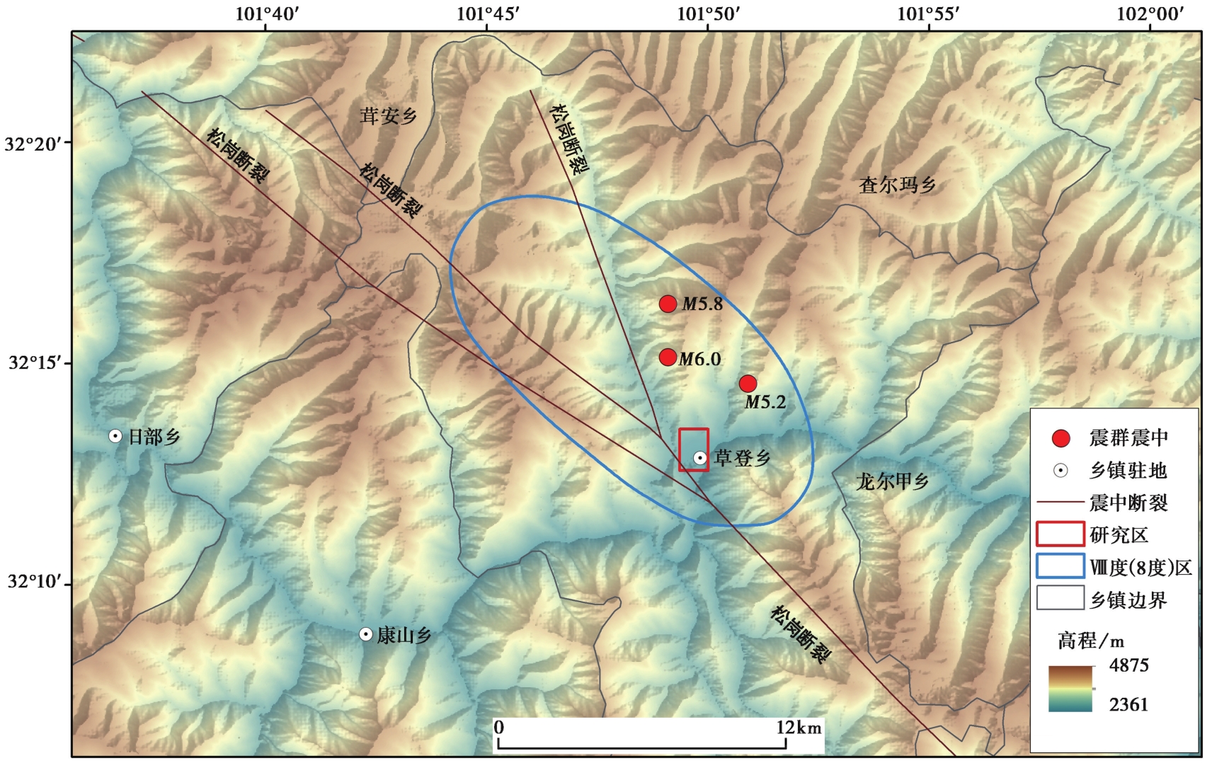
图 1 研究区的区域概况图
Fig. 1 Overview of the study area in the Maerkang M6.0 earthquake swarm.
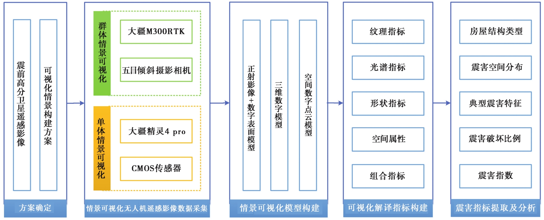
图 2 基于倾斜摄影技术的典型情景可视化震害定量评估技术流程
Fig. 2 Workflow of typical scenario visualization for seismic damage extraction based on oblique photography.
| 无人机参数指标 | M300 RTK技术参数 | 精灵4 Pro V2.0技术参数 |
|---|---|---|
| 重量 | 6.3kg(含2块电池) | 1.4kg |
| 最大飞行海拔高度 | 5000m(2110桨叶,起飞重量≤7kg) | 6000m |
| 悬停精度 | 垂直精度: ±0.1m;水平精度: ±0.1m | 垂直精度: ±0.1m;水平精度: ±0.3m |
| 最大旋转角速度 | 俯仰轴: 300°/s;航向轴: 100°/s | 俯仰轴: 250°/s;航向轴: 150°/s |
| 最大上升速度 | 运动模式: 6m/s;定位模式: 5m/s | 运动模式: 6m/s;定位模式: 5m/s |
| 最大下降速度 | 运动模式: 5m/s;定位模式: 4m/s | 运动模式: 4m/s;定位模式: 3m/s |
| 最大可承受风速 | 15m/s(7级风) | 10m/s(5级风) |
表 1 无人机系统的性能参数
Table 1 Specifications of UAV system
| 无人机参数指标 | M300 RTK技术参数 | 精灵4 Pro V2.0技术参数 |
|---|---|---|
| 重量 | 6.3kg(含2块电池) | 1.4kg |
| 最大飞行海拔高度 | 5000m(2110桨叶,起飞重量≤7kg) | 6000m |
| 悬停精度 | 垂直精度: ±0.1m;水平精度: ±0.1m | 垂直精度: ±0.1m;水平精度: ±0.3m |
| 最大旋转角速度 | 俯仰轴: 300°/s;航向轴: 100°/s | 俯仰轴: 250°/s;航向轴: 150°/s |
| 最大上升速度 | 运动模式: 6m/s;定位模式: 5m/s | 运动模式: 6m/s;定位模式: 5m/s |
| 最大下降速度 | 运动模式: 5m/s;定位模式: 4m/s | 运动模式: 4m/s;定位模式: 3m/s |
| 最大可承受风速 | 15m/s(7级风) | 10m/s(5级风) |
| 无人机荷载参数指标 | MS Smart2技术参数 | CMOS技术参数 |
|---|---|---|
| 镜头数量 | 5个 | 1个 |
| 传感器尺寸 | 22.3×14.9mm | 12.8×9.6mm |
| 照片尺寸 | 6000×4000Pix | 5472×3078Pix |
| 最小拍照间隔 | 0.2s | 2s |
| 有效像素 | 2430万(总像素>1.2亿) | 2000万 |
表 2 无人机倾斜摄影系统的性能参数
Table 2 Specifications of UAV photography system
| 无人机荷载参数指标 | MS Smart2技术参数 | CMOS技术参数 |
|---|---|---|
| 镜头数量 | 5个 | 1个 |
| 传感器尺寸 | 22.3×14.9mm | 12.8×9.6mm |
| 照片尺寸 | 6000×4000Pix | 5472×3078Pix |
| 最小拍照间隔 | 0.2s | 2s |
| 有效像素 | 2430万(总像素>1.2亿) | 2000万 |
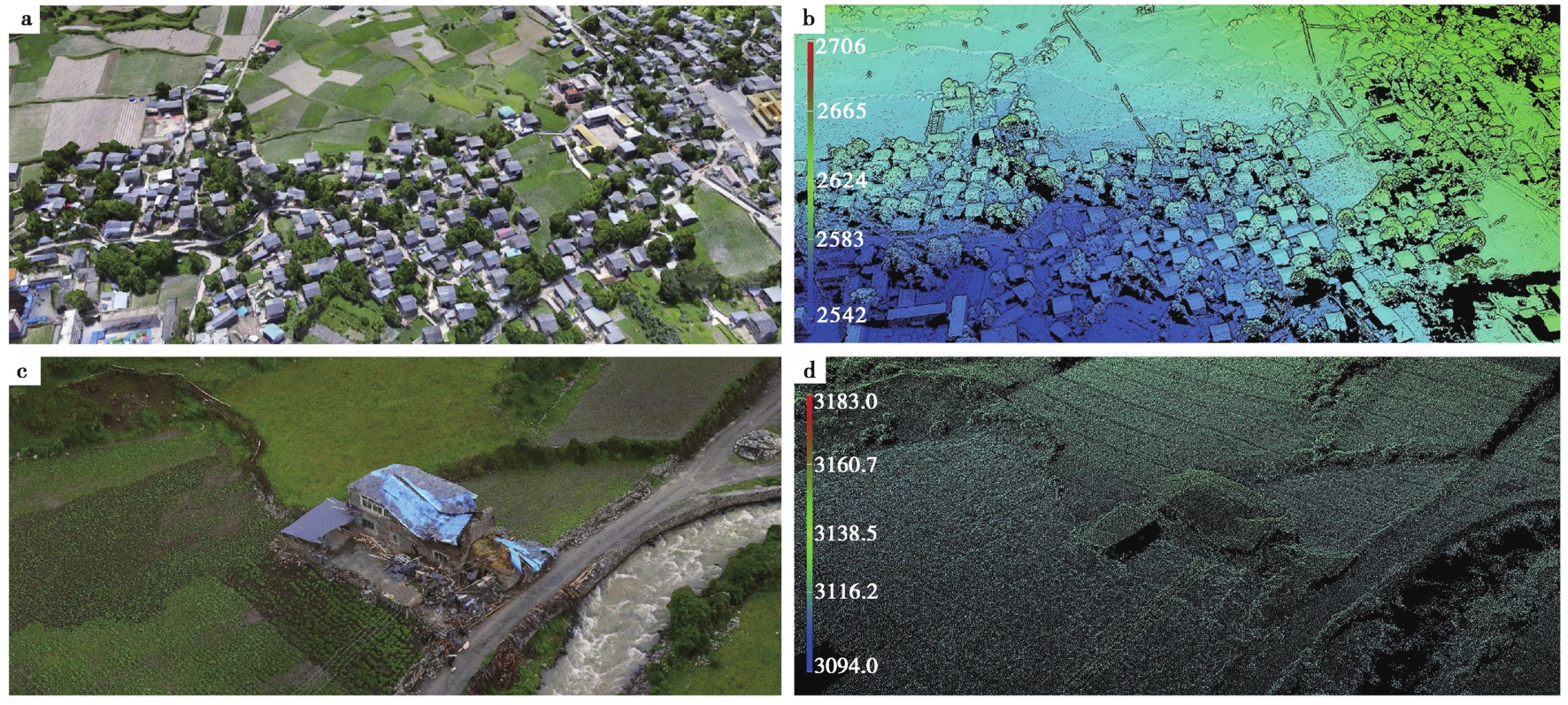
图 3 马尔康市草登乡典型情景可视化 a 建筑物群体情景可视化模型; b 建筑物群体情景可视化点云模型; c 建筑物单体情景可视化模型; d 建筑物单体情景可视化点云模型
Fig. 3 Typical scenario visualization of Caodeng Town, Maerkang City.
| 破坏等级 | 情景可视化解译指标 | 典型震害(正射视角) | 典型震害(倾斜视角) |
|---|---|---|---|
| 基本完好 | 建造规整,房屋轮廓清晰,建筑物与周边环境纹理或色调分界清晰,周边环境色调过渡自然,侧立面整齐,外墙和窗户无破坏。 | | |
| 轻微破坏 | 建造规整,房屋轮廓清晰,建筑物与周边环境纹理或色调分界清晰,屋顶覆盖的少数片石因轻微位移呈相对亮斑状,侧立面整齐,少数外墙出现一般性裂缝,极少数窗户有破坏。 | | |
| 中等破坏 | 建筑物与周边环境纹理或色调过度相对模糊,屋顶覆盖的多数片石因明显位移或轻微落瓦呈明显亮斑状。部分外墙有少数“X”型裂缝和墙皮脱落,纹理不规则,部分窗户出现变形和破坏。 | | |
| 严重破坏 | 屋顶覆盖的多数片石因明显位移或落瓦呈明显亮斑状,部分屋顶坍塌导致纹理模糊或点云差异。侧立面不规整,多数外墙有贯穿性裂缝和墙皮脱落现象,纹理极不规则,多数窗户出现变形和破坏。 | | |
| 毁坏 | 屋顶覆盖的片石因明显位移或落瓦呈明显亮斑状,屋顶部分坍塌或整体坍塌,导致纹理混乱或点云明显差异,侧立面残缺或极不规整。 | | |
表 3 情景可视化震害的解译标志
Table 3 Scenario visualization of seismic damage interpretation sign
| 破坏等级 | 情景可视化解译指标 | 典型震害(正射视角) | 典型震害(倾斜视角) |
|---|---|---|---|
| 基本完好 | 建造规整,房屋轮廓清晰,建筑物与周边环境纹理或色调分界清晰,周边环境色调过渡自然,侧立面整齐,外墙和窗户无破坏。 | | |
| 轻微破坏 | 建造规整,房屋轮廓清晰,建筑物与周边环境纹理或色调分界清晰,屋顶覆盖的少数片石因轻微位移呈相对亮斑状,侧立面整齐,少数外墙出现一般性裂缝,极少数窗户有破坏。 | | |
| 中等破坏 | 建筑物与周边环境纹理或色调过度相对模糊,屋顶覆盖的多数片石因明显位移或轻微落瓦呈明显亮斑状。部分外墙有少数“X”型裂缝和墙皮脱落,纹理不规则,部分窗户出现变形和破坏。 | | |
| 严重破坏 | 屋顶覆盖的多数片石因明显位移或落瓦呈明显亮斑状,部分屋顶坍塌导致纹理模糊或点云差异。侧立面不规整,多数外墙有贯穿性裂缝和墙皮脱落现象,纹理极不规则,多数窗户出现变形和破坏。 | | |
| 毁坏 | 屋顶覆盖的片石因明显位移或落瓦呈明显亮斑状,屋顶部分坍塌或整体坍塌,导致纹理混乱或点云明显差异,侧立面残缺或极不规整。 | | |
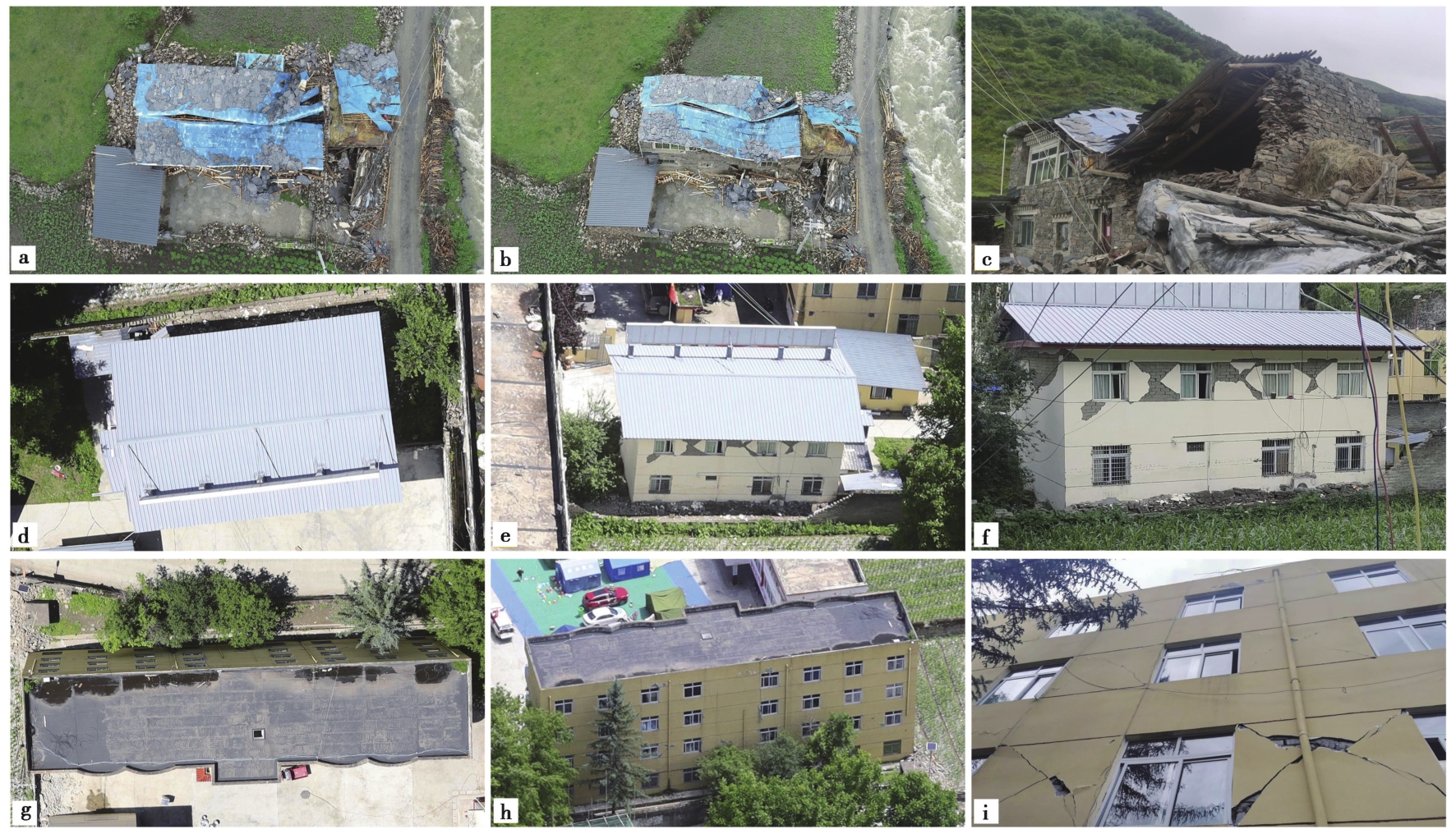
图 4 不同结构类型典型建筑的正射、 倾斜摄影、 现场调查影像 a、 d、 g 正射影像; b、 e、 h 倾斜摄影影像; c、 f、 i 现场调查照片
Fig. 4 Orthophoto, oblique photography, and field survey images of typical buildings of different structural types.
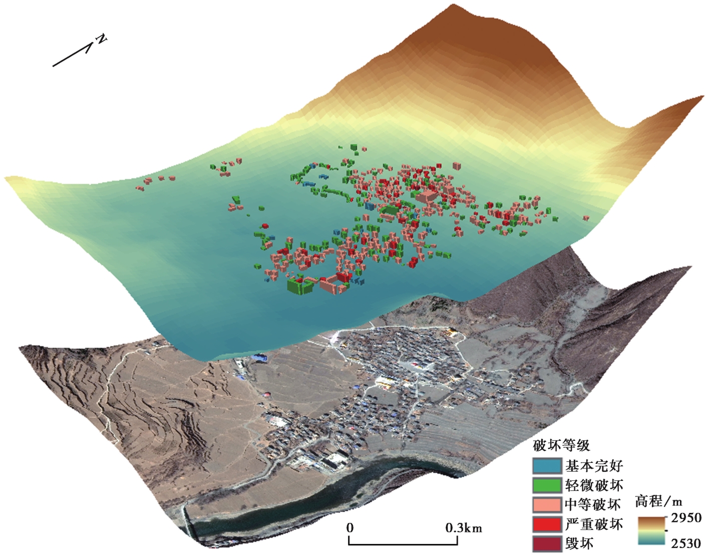
图 5 研究区典型情景可视化震害评估结果分布图
Fig. 5 Distribution of visualized seismic damage assessment results for typical scenarios in the study area.
| 分类精度评价 | 现场调查 | |||||||
|---|---|---|---|---|---|---|---|---|
| 毁坏 | 严重破坏 | 中等破坏 | 轻微破坏 | 基本完好 | 合计 | UA/% | ||
| 情景可视化解译 | 毁坏 | 6 | 0 | 0 | 0 | 0 | 6 | 100 |
| 严重破坏 | 0 | 36 | 0 | 0 | 0 | 36 | 100 | |
| 中等破坏 | 0 | 16 | 276 | 0 | 0 | 292 | 95 | |
| 轻微破坏 | 0 | 1 | 11 | 145 | 2 | 159 | 91 | |
| 基本完好 | 0 | 0 | 1 | 10 | 16 | 27 | 59 | |
| 合计 | 6 | 53 | 288 | 155 | 18 | 520 | ||
| PA/% | 100 | 68 | 96 | 94 | 89 | |||
表 4 建筑物情景可视化震害评估结果与现场调查结果的分类精度(按栋进行统计)
Table 4 Classification accuracy of earthquake damage assessment results from building scenario visualization and field survey results(statistics by building)
| 分类精度评价 | 现场调查 | |||||||
|---|---|---|---|---|---|---|---|---|
| 毁坏 | 严重破坏 | 中等破坏 | 轻微破坏 | 基本完好 | 合计 | UA/% | ||
| 情景可视化解译 | 毁坏 | 6 | 0 | 0 | 0 | 0 | 6 | 100 |
| 严重破坏 | 0 | 36 | 0 | 0 | 0 | 36 | 100 | |
| 中等破坏 | 0 | 16 | 276 | 0 | 0 | 292 | 95 | |
| 轻微破坏 | 0 | 1 | 11 | 145 | 2 | 159 | 91 | |
| 基本完好 | 0 | 0 | 1 | 10 | 16 | 27 | 59 | |
| 合计 | 6 | 53 | 288 | 155 | 18 | 520 | ||
| PA/% | 100 | 68 | 96 | 94 | 89 | |||
| 分类精度评价 | 现场调查 | |||||||
|---|---|---|---|---|---|---|---|---|
| 毁坏 | 严重破坏 | 中等破坏 | 轻微破坏 | 基本完好 | 合计 | UA/% | ||
| 正射遥感影像解译 | 毁坏 | 6 | 0 | 0 | 0 | 0 | 6 | 100 |
| 严重破坏 | 0 | 24 | 2 | 0 | 0 | 26 | 92 | |
| 中等破坏 | 0 | 15 | 137 | 2 | 0 | 154 | 89 | |
| 轻微破坏 | 0 | 9 | 82 | 49 | 1 | 141 | 35 | |
| 基本完好 | 0 | 5 | 67 | 104 | 17 | 193 | 9 | |
| 合计 | 6 | 53 | 288 | 155 | 18 | 520 | ||
| PA/% | 100 | 45 | 48 | 32 | 94 | |||
表 5 建筑物正射遥感影像震害评估结果与现场调查结果的分类精度(按栋进行统计)
Table 5 Classification accuracy of seismic damage assessment results from orthophoto remote sensing images of buildings and field survey results(statistics by building)
| 分类精度评价 | 现场调查 | |||||||
|---|---|---|---|---|---|---|---|---|
| 毁坏 | 严重破坏 | 中等破坏 | 轻微破坏 | 基本完好 | 合计 | UA/% | ||
| 正射遥感影像解译 | 毁坏 | 6 | 0 | 0 | 0 | 0 | 6 | 100 |
| 严重破坏 | 0 | 24 | 2 | 0 | 0 | 26 | 92 | |
| 中等破坏 | 0 | 15 | 137 | 2 | 0 | 154 | 89 | |
| 轻微破坏 | 0 | 9 | 82 | 49 | 1 | 141 | 35 | |
| 基本完好 | 0 | 5 | 67 | 104 | 17 | 193 | 9 | |
| 合计 | 6 | 53 | 288 | 155 | 18 | 520 | ||
| PA/% | 100 | 45 | 48 | 32 | 94 | |||
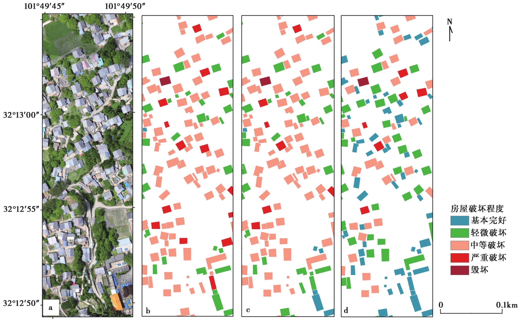
图 6 研究区局部建筑物震害破坏信息的评估结果 a 研究区局部遥感影像; b 现场调查震害评定结果; c 情景可视化震害评估结果; d 正射遥感影像震害评估结果
Fig. 6 Assessment results of localized building seismic damage information in the study area.
| [1] |
杜浩国, 林旭川, 张建国, 等. 2021. 基于改进蚁群算法与无人机影像的震害识别方法及其在漾濞地震中的应用[J]. 地震地质, 43(4): 1013-1029. doi: 10.3969/j.issn.0253-4967.2021.04.018.
DOI |
|
|
|
| [2] |
范熙伟, 聂高众, 邓砚, 等. 2017. 基于摄影测量技术的房屋提取方法: 以中国西部地区乡村为例[J]. 地震地质, 39(4): 805-818. doi: 10.3969/j.issn.0253-4967.2017.04.014.
DOI |
|
|
|
| [3] |
国家市场监督管理总局, 国家标准化管理委员会. 2020. 中国地震烈度表(GB/T 17742-2020)[S]. 北京: 中国标准出版社.
|
|
State Administration for Market Regulation, Inspection and Quarantine of the People's Republic of China, Standards Administration of China. 2020. The Chinese Seismic Intensity Scale(GB/T 17742-2020)[S]. Standards Press of China, Beijing(in Chinese) (in Chinese).
|
|
| [4] |
刘静, 陈涛, 张培震, 等. 2013. 机载激光雷达扫描揭示海原断裂带微地貌的精细结构[J]. 科学通报, 58(1): 41-45.
|
|
|
|
| [5] |
帅向华, 刘钦, 甄盟, 等. 2018. 倾斜摄影技术在云南鲁甸地震现场的应用研究[J]. 震灾防御技术, 13(1): 158-167.
|
|
|
|
| [6] |
孙家抦. 2013. 遥感原理与应用(第3版)[M]. 武汉: 武汉大学出版社.
|
|
|
|
| [7] |
王晓青, 窦爱霞, 丁香, 等. 2015. 地震烈度应急遥感评估研究与应用进展[J]. 地球信息科学学报, 17(12): 1536-1544.
DOI |
|
|
|
| [8] |
王晓青, 窦爱霞, 孙国清, 等. 2013. 基于综合震害指数的玉树地震烈度遥感评估研究[J]. 地震, 33(2): 1-10.
|
|
|
|
| [9] |
肖本夫, 吴今生, 毛利, 等. 2021. 基于深度学习网络的地震地质灾害识别研究: 以四川九寨沟7.0级地震为例[J]. 震灾防御技术, 16(4): 617-624.
|
|
|
|
| [10] |
袁小祥, 王晓青, 丁香, 等. 2017. 基于无人机影像的九寨沟地震建筑物震害定量评估[J]. 中国地震, 33(4): 582-589.
|
|
|
|
| [11] |
袁小祥, 王晓青, 窦爱霞, 等. 2012. 基于地面LiDAR玉树地震地表破裂的三维建模分析[J]. 地震地质, 34(1): 39-46. doi: 10.3969/j.issn.0253-4967.2012.01.005.
DOI |
|
|
|
| [12] |
张景发, 李强, 张庆云, 等. 2018. 多源遥感图像的1976年 MS7.8 唐山大地震等烈度区判定[J]. 遥感学报, 22(S1): 162-173.
|
|
|
|
| [13] |
张永久, 彭立国, 程万正. 2006. 马尔康地震序列震源参数研究[J]. 中国地震, 22(1): 85-93.
|
|
|
|
| [14] |
中国地震局. 2018. 地震灾害遥感评估建筑物破坏(DB/T 75-2018)[S]. 北京: 中国标准出版社.
|
|
China Earthquake Administration. 2018. Earthquake Disaster Assessment based on Remote Sensing: Building Damage(DB/ T 75-2018)[S]. Standards Press of China, Beijing (in Chinese).
|
|
| [15] |
中华人民共和国国家质量监督检验检疫总局, 中国国家标准化管理委员会. 2009. 建(构)筑物地震破坏等级划分(GB/T 24335-2009)[S]. 北京: 中国标准出版社.
|
|
General Administration of Quality Supervision, Inspection and Quarantine of the People's Republic of China,Standards Administration of China. 2009. Classification of Earthquake Damage to Buildings and Special Structures(GB/T 24335-2009)[S]. Standards Press of China, Beijing (in Chinese).
|
|
| [16] |
DOI |
| [17] |
DOI URL |
| [18] |
DOI |
| [19] |
DOI URL |
| [20] |
|
| [21] |
DOI URL |
| [22] |
DOI URL |
| [23] |
DOI URL |
| [24] |
|
| [25] |
DOI URL |
| [26] |
|
| [27] |
DOI |
| [28] |
DOI URL |
| [29] |
DOI |
| [30] |
DOI URL |
| [31] |
DOI URL |
| [32] |
Sharma,
DOI URL |
| [33] |
DOI URL |
| [34] |
DOI |
| [35] |
|
| [36] |
DOI URL |
| [37] |
DOI URL |
| [38] |
DOI URL |
| No related articles found! |
| 阅读次数 | ||||||
|
全文 |
|
|||||
|
摘要 |
|
|||||
