地震地质 ›› 2023, Vol. 45 ›› Issue (5): 1147-1169.DOI: 10.3969/j.issn.0253-4967.2023.05.007
徐如刚1,2,3)( ), 张新林4)(), 梁霄1), 孙鸿博1), 储飞1), 黄显良1,3), 谈洪波4), 汪健4)
收稿日期:2022-11-07
修回日期:2022-12-28
出版日期:2023-11-23
发布日期:2023-11-23
作者简介:徐如刚, 男, 1980年生, 2007年于中国地震局地震研究所获固体地球物理学专业硕士学位, 高级工程师, 主要从事重力数据处理与反演研究, E-mail: Rugang_xu@mail.ustc.edu.cn。
张新林, 男, 1980年生, 助理研究员, 主要从事重力观测数据解释和地震位错理论研究, E-mail: xinlinzhang2012@163.com。
共同第一作者
基金资助:
XU Ru-gang1,2,3)(), ZHANG Xin-lin4)(), LIANG Xiao1), SUN Hong-bo1), CHU Fei1), HUANG Xian-liang1,3), TAN Hong-bo4), WANG Jian4)
Received:2022-11-07
Revised:2022-12-28
Online:2023-11-23
Published:2023-11-23
摘要:
在地震重力区域监测网数据处理过程中, 相对重力仪的格值标定和基准控制通常采用本网内的绝对重力基准值, 由于仪器格值和控制基准的影响相互耦合, 难以定量分析格值、 基准控制对测网数据平差处理的影响。文中基于大别山金寨重力基线场的混合重力测量数据, 解耦了格值、 基准控制的影响, 获得了金寨重力基线场的初值。结果表明: 金寨重力基线场可以满足安徽地震重力测网仪器标定的需求, 对提升监测效率、 节约经济成本具有重要意义, 也可为其他基线场、 地震重力区域监测网数据处理提供参考。
徐如刚, 张新林, 梁霄, 孙鸿博, 储飞, 黄显良, 谈洪波, 汪健. 大别山金寨重力基线场混合重力测量试验与分析[J]. 地震地质, 2023, 45(5): 1147-1169.
XU Ru-gang, ZHANG Xin-lin, LIANG Xiao, SUN Hong-bo, CHU Fei, HUANG Xian-liang, TAN Hong-bo, WANG Jian. ANALYSIS FOR SYNTHETIC ADJUSTMENT OF ABSOLUTE AND RELATIVE GRAVITY OF JINZHAI GRAVITY BASELINE IN DABIE MOUNTAIN[J]. SEISMOLOGY AND GEOLOGY, 2023, 45(5): 1147-1169.
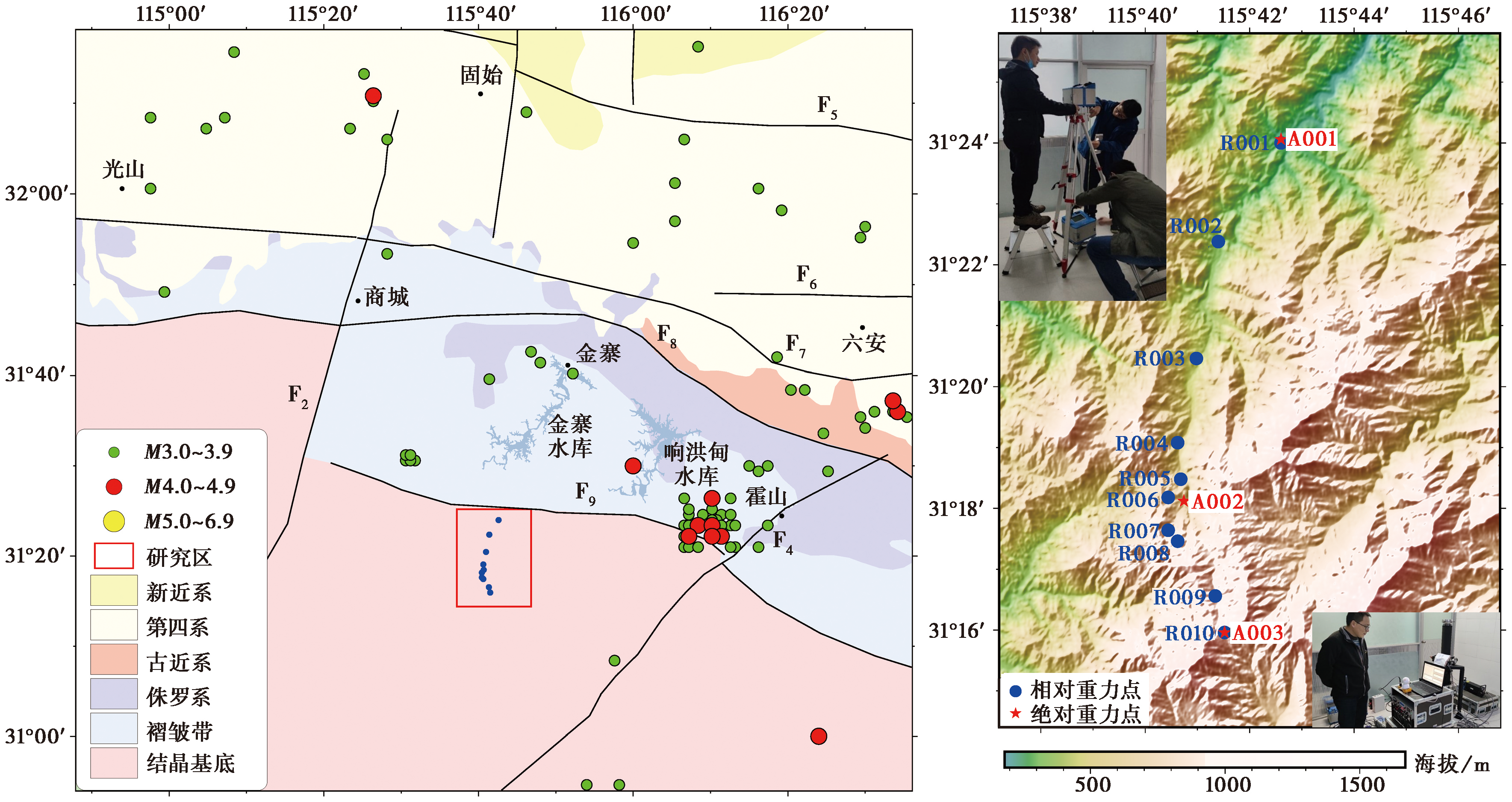
图1 金寨重力基线场周边区域的地层、 断裂构造与地震震中分布 F2商城-麻城断裂; F4落儿岭-土地岭断裂; F5肥中断裂; F6六安-合肥断裂; F7肥西-韩摆渡断裂; F8梅山-龙河口断裂; F9青山-晓天断裂
Fig. 1 Distribution of strata, fault structures, and earthquake epicenter around the Jinzhai gravity baseline and its adjacent area.
| 测点类型 | 点名 | 北纬/(°) | 东经/(°) | 高程/m |
|---|---|---|---|---|
| 绝对重力基准控制点 | A001 | 31.40 | 115.71 | 239.0 |
| A002 | 31.30 | 115.67 | 686.0 | |
| A003 | 31.26 | 115.69 | 1249.2 | |
| 相对重力联测基本点 | R001 | 31.40 | 115.71 | 238.0 |
| R002 | 31.37 | 115.69 | 331.0 | |
| R003 | 31.34 | 115.68 | 416.0 | |
| R004 | 31.31 | 115.67 | 541.0 | |
| R005 | 31.30 | 115.67 | 631.9 | |
| R006 | 31.30 | 115.67 | 776.7 | |
| R007 | 31.29 | 115.67 | 901.8 | |
| R008 | 31.29 | 115.67 | 1002.1 | |
| R009 | 31.27 | 115.68 | 1147.0 | |
| R010 | 31.26 | 115.69 | 1249.2 |
表1 金寨重力基线场重力基点的点位信息
Table 1 Gravity base point information in Jinzhai gravity baseline
| 测点类型 | 点名 | 北纬/(°) | 东经/(°) | 高程/m |
|---|---|---|---|---|
| 绝对重力基准控制点 | A001 | 31.40 | 115.71 | 239.0 |
| A002 | 31.30 | 115.67 | 686.0 | |
| A003 | 31.26 | 115.69 | 1249.2 | |
| 相对重力联测基本点 | R001 | 31.40 | 115.71 | 238.0 |
| R002 | 31.37 | 115.69 | 331.0 | |
| R003 | 31.34 | 115.68 | 416.0 | |
| R004 | 31.31 | 115.67 | 541.0 | |
| R005 | 31.30 | 115.67 | 631.9 | |
| R006 | 31.30 | 115.67 | 776.7 | |
| R007 | 31.29 | 115.67 | 901.8 | |
| R008 | 31.29 | 115.67 | 1002.1 | |
| R009 | 31.27 | 115.68 | 1147.0 | |
| R010 | 31.26 | 115.69 | 1249.2 |
| 测段 | 段差均值/mGal | 仪器互差/μGal | 仪器自差/μGal | 段差精度/μGal | |
|---|---|---|---|---|---|
| CG6-092 | CG6-090 | ||||
| A001—R001 | -0.0052 | 4.0 | 5.1 | 2.3 | 2.0 |
| R001—R002 | 25.1815 | 14.7 | 8.6 | 2.3 | 7.3 |
| R002—R003 | 23.2954 | 5.8 | 2.4 | 1.3 | 2.9 |
| R003—R004 | 29.5764 | 7.8 | 2.8 | 1.9 | 3.9 |
| R004—R005 | 19.8655 | 9.5 | 8.0 | 4.4 | 4.7 |
| R005—A002 | 10.0508 | 0.9 | 2.5 | 1.4 | 0.4 |
| A002—R006 | 16.8296 | 6.7 | 1.8 | 3.3 | 3.3 |
| R006—R007 | 27.1767 | 5.3 | 4.2 | 6 | 2.6 |
| R007—R008 | 20.8883 | 4.5 | 4.0 | 4.5 | 2.2 |
| R008—R009 | 28.0777 | 14.8 | 2.0 | 5.1 | 7.4 |
| R009—R010 | 24.2056 | 8.3 | 3.3 | 4.8 | 4.1 |
表2 金寨重力基线场的相对重力联测结果
Table 2 The results of relative gravity survey in the Jinzhai gravity baseline
| 测段 | 段差均值/mGal | 仪器互差/μGal | 仪器自差/μGal | 段差精度/μGal | |
|---|---|---|---|---|---|
| CG6-092 | CG6-090 | ||||
| A001—R001 | -0.0052 | 4.0 | 5.1 | 2.3 | 2.0 |
| R001—R002 | 25.1815 | 14.7 | 8.6 | 2.3 | 7.3 |
| R002—R003 | 23.2954 | 5.8 | 2.4 | 1.3 | 2.9 |
| R003—R004 | 29.5764 | 7.8 | 2.8 | 1.9 | 3.9 |
| R004—R005 | 19.8655 | 9.5 | 8.0 | 4.4 | 4.7 |
| R005—A002 | 10.0508 | 0.9 | 2.5 | 1.4 | 0.4 |
| A002—R006 | 16.8296 | 6.7 | 1.8 | 3.3 | 3.3 |
| R006—R007 | 27.1767 | 5.3 | 4.2 | 6 | 2.6 |
| R007—R008 | 20.8883 | 4.5 | 4.0 | 4.5 | 2.2 |
| R008—R009 | 28.0777 | 14.8 | 2.0 | 5.1 | 7.4 |
| R009—R010 | 24.2056 | 8.3 | 3.3 | 4.8 | 4.1 |
| 点位 | 观测日期 | 观测 组数 | 有效 组数 | 垂直梯度 /μGal·cm-1 | 梯度段差精度 /μGal | 墩面重力值 /μGal | 组间离散度 /μGal | 天气 |
|---|---|---|---|---|---|---|---|---|
| A001 | 2022-03-25 | 20 | 20 | -2.682 | 0.5297 | 97****** 7.71 | 1.08 | 小雨 |
| A002 | 2022-03-26 | 18 | 18 | -2.121 | 0.7654 | 97****** 2.04 | 1.12 | 晴 |
| A003 | 2022-03-27 | 18 | 18 | -3.014 | 0.8980 | 97****** 8.26 | 0.86 | 晴 |
表3 金寨重力基线场绝对重力及梯度观测结果
Table 3 The results of the absolute gravity and gravity gradient survey in the Jinzhai gravity baseline
| 点位 | 观测日期 | 观测 组数 | 有效 组数 | 垂直梯度 /μGal·cm-1 | 梯度段差精度 /μGal | 墩面重力值 /μGal | 组间离散度 /μGal | 天气 |
|---|---|---|---|---|---|---|---|---|
| A001 | 2022-03-25 | 20 | 20 | -2.682 | 0.5297 | 97****** 7.71 | 1.08 | 小雨 |
| A002 | 2022-03-26 | 18 | 18 | -2.121 | 0.7654 | 97****** 2.04 | 1.12 | 晴 |
| A003 | 2022-03-27 | 18 | 18 | -3.014 | 0.8980 | 97****** 8.26 | 0.86 | 晴 |
| 仪器 | 不同控制基准组合 | ||||
|---|---|---|---|---|---|
| 格值13 A001+A003 | 格值123 A001+A002+A003 | 格值12 A001+A002 | 格值23 A002+A003 | 格值WYB 武汉—宜昌—巴东 | |
| CG6-090 | 1.000169±0.000038 | 1.000158±0.000033 | 1.000382±0.000050 | 0.999973±0.000048 | 1.000186±0.000059 |
| CG6-092 | 0.999815±0.000038 | 0.999804±0.000033 | 1.000029±0.000050 | 0.999618±0.000048 | 0.999862±0.000059 |
表4 不同控制基准组合对应的仪器格值及精度
Table 4 The results of the gravimeter scale and its accuracy corresponding to different control benchmarks
| 仪器 | 不同控制基准组合 | ||||
|---|---|---|---|---|---|
| 格值13 A001+A003 | 格值123 A001+A002+A003 | 格值12 A001+A002 | 格值23 A002+A003 | 格值WYB 武汉—宜昌—巴东 | |
| CG6-090 | 1.000169±0.000038 | 1.000158±0.000033 | 1.000382±0.000050 | 0.999973±0.000048 | 1.000186±0.000059 |
| CG6-092 | 0.999815±0.000038 | 0.999804±0.000033 | 1.000029±0.000050 | 0.999618±0.000048 | 0.999862±0.000059 |
| 段名 | 基准 A001、A002 | 基准 A001、A002、A003 | 基准 A001、A003 | 基准 A002、A003 | ||||||||
|---|---|---|---|---|---|---|---|---|---|---|---|---|
| 段差/mGal | 互差/μGal | 精度/μGal | 段差/mGal | 互差/μGal | 精度/μGal | 段差/mGal | 互差/μGal | 精度/μGal | 段差/mGal | 互差/μGal | 精度/μGal | |
| A001—R001 | 0.006 | 3 | 1 | 0.006 | 3 | 1 | 0.006 | 3 | 1 | 0.006 | 3 | 1 |
| R001—R002 | -25.181 | 14 | 7 | -25.181 | 14 | 7 | -25.181 | 14 | 7 | -25.181 | 14 | 7 |
| R002—R003 | -23.295 | 5 | 2 | -23.295 | 5 | 2 | -23.295 | 5 | 2 | -23.295 | 5 | 2 |
| R003—R004 | -29.577 | 7 | 3 | -29.577 | 7 | 3 | -29.577 | 7 | 3 | -29.577 | 7 | 3 |
| R004—R005 | -19.865 | 9 | 4 | -19.865 | 9 | 4 | -19.865 | 9 | 4 | -19.865 | 9 | 4 |
| R005—A002 | -10.051 | 0 | 0 | -10.051 | 0 | 0 | -10.051 | 0 | 0 | -10.051 | 0 | 0 |
| A002—R006 | -16.829 | 6 | 3 | -16.829 | 6 | 3 | -16.829 | 6 | 3 | -16.829 | 6 | 3 |
| R006—R007 | -27.177 | 5 | 2 | -27.177 | 5 | 2 | -27.177 | 5 | 2 | -27.177 | 5 | 2 |
| R007—R008 | -20.888 | 4 | 2 | -20.888 | 4 | 2 | -20.888 | 4 | 2 | -20.888 | 4 | 2 |
| R008—R009 | -28.078 | 14 | 7 | -28.078 | 14 | 7 | -28.078 | 14 | 7 | -28.078 | 14 | 7 |
| R009—A003 | -24.205 | 8 | 4 | -24.205 | 8 | 4 | -24.205 | 8 | 4 | -24.205 | 8 | 4 |
表5 “格值1”不同基准控制段的差值及精度
Table 5 Section difference and its accuracy corresponding to “scale 1” and different control benchmarks
| 段名 | 基准 A001、A002 | 基准 A001、A002、A003 | 基准 A001、A003 | 基准 A002、A003 | ||||||||
|---|---|---|---|---|---|---|---|---|---|---|---|---|
| 段差/mGal | 互差/μGal | 精度/μGal | 段差/mGal | 互差/μGal | 精度/μGal | 段差/mGal | 互差/μGal | 精度/μGal | 段差/mGal | 互差/μGal | 精度/μGal | |
| A001—R001 | 0.006 | 3 | 1 | 0.006 | 3 | 1 | 0.006 | 3 | 1 | 0.006 | 3 | 1 |
| R001—R002 | -25.181 | 14 | 7 | -25.181 | 14 | 7 | -25.181 | 14 | 7 | -25.181 | 14 | 7 |
| R002—R003 | -23.295 | 5 | 2 | -23.295 | 5 | 2 | -23.295 | 5 | 2 | -23.295 | 5 | 2 |
| R003—R004 | -29.577 | 7 | 3 | -29.577 | 7 | 3 | -29.577 | 7 | 3 | -29.577 | 7 | 3 |
| R004—R005 | -19.865 | 9 | 4 | -19.865 | 9 | 4 | -19.865 | 9 | 4 | -19.865 | 9 | 4 |
| R005—A002 | -10.051 | 0 | 0 | -10.051 | 0 | 0 | -10.051 | 0 | 0 | -10.051 | 0 | 0 |
| A002—R006 | -16.829 | 6 | 3 | -16.829 | 6 | 3 | -16.829 | 6 | 3 | -16.829 | 6 | 3 |
| R006—R007 | -27.177 | 5 | 2 | -27.177 | 5 | 2 | -27.177 | 5 | 2 | -27.177 | 5 | 2 |
| R007—R008 | -20.888 | 4 | 2 | -20.888 | 4 | 2 | -20.888 | 4 | 2 | -20.888 | 4 | 2 |
| R008—R009 | -28.078 | 14 | 7 | -28.078 | 14 | 7 | -28.078 | 14 | 7 | -28.078 | 14 | 7 |
| R009—A003 | -24.205 | 8 | 4 | -24.205 | 8 | 4 | -24.205 | 8 | 4 | -24.205 | 8 | 4 |
| 段名 | 基准 A001、A002 | 基准 A001、A002、A003 | 基准 A001、A003 | 基准 A002、A003 | ||||||||
|---|---|---|---|---|---|---|---|---|---|---|---|---|
| 段差/mGal | 互差/μGal | 精度/μGal | 段差/mGal | 互差/μGal | 精度/μGal | 段差/mGal | 互差/μGal | 精度/μGal | 段差/mGal | 互差/μGal | 精度/μGal | |
| A001—R001 | 0.006 | 3 | 1 | 0.006 | 3 | 1 | 0.006 | 3 | 1 | 0.006 | 3 | 1 |
| R001—R002 | -25.187 | 5 | 2 | -25.187 | 5 | 2 | -25.187 | 5 | 2 | -25.187 | 5 | 2 |
| R002—R003 | -23.3 | 2 | 1 | -23.3 | 2 | 1 | -23.3 | 2 | 1 | -23.3 | 2 | 1 |
| R003—R004 | -29.583 | 2 | 1 | -29.583 | 2 | 1 | -29.583 | 2 | 1 | -29.583 | 2 | 1 |
| R004—R005 | -19.869 | 2 | 1 | -19.869 | 2 | 1 | -19.869 | 2 | 1 | -19.869 | 2 | 1 |
| R005—A002 | -10.053 | 2 | 1 | -10.053 | 2 | 1 | -10.053 | 2 | 1 | -10.053 | 2 | 1 |
| A002—R006 | -16.833 | 0 | 0 | -16.833 | 0 | 0 | -16.833 | 0 | 0 | -16.833 | 0 | 0 |
| R006—R007 | -27.182 | 4 | 2 | -27.182 | 4 | 2 | -27.182 | 4 | 2 | -27.182 | 4 | 2 |
| R007—R008 | -20.893 | 2 | 1 | -20.893 | 2 | 1 | -20.893 | 2 | 1 | -20.893 | 2 | 1 |
| R008—R009 | -28.084 | 4 | 2 | -28.084 | 4 | 2 | -28.084 | 4 | 2 | -28.084 | 4 | 2 |
| R009—A003 | -24.21 | 0 | 0 | -24.21 | 0 | 0 | -24.21 | 0 | 0 | -24.21 | 0 | 0 |
表6 “格值12”不同基准控制段的差值及精度
Table 6 Section difference and its accuracy corresponding to “scale 12” and different control benchmarks
| 段名 | 基准 A001、A002 | 基准 A001、A002、A003 | 基准 A001、A003 | 基准 A002、A003 | ||||||||
|---|---|---|---|---|---|---|---|---|---|---|---|---|
| 段差/mGal | 互差/μGal | 精度/μGal | 段差/mGal | 互差/μGal | 精度/μGal | 段差/mGal | 互差/μGal | 精度/μGal | 段差/mGal | 互差/μGal | 精度/μGal | |
| A001—R001 | 0.006 | 3 | 1 | 0.006 | 3 | 1 | 0.006 | 3 | 1 | 0.006 | 3 | 1 |
| R001—R002 | -25.187 | 5 | 2 | -25.187 | 5 | 2 | -25.187 | 5 | 2 | -25.187 | 5 | 2 |
| R002—R003 | -23.3 | 2 | 1 | -23.3 | 2 | 1 | -23.3 | 2 | 1 | -23.3 | 2 | 1 |
| R003—R004 | -29.583 | 2 | 1 | -29.583 | 2 | 1 | -29.583 | 2 | 1 | -29.583 | 2 | 1 |
| R004—R005 | -19.869 | 2 | 1 | -19.869 | 2 | 1 | -19.869 | 2 | 1 | -19.869 | 2 | 1 |
| R005—A002 | -10.053 | 2 | 1 | -10.053 | 2 | 1 | -10.053 | 2 | 1 | -10.053 | 2 | 1 |
| A002—R006 | -16.833 | 0 | 0 | -16.833 | 0 | 0 | -16.833 | 0 | 0 | -16.833 | 0 | 0 |
| R006—R007 | -27.182 | 4 | 2 | -27.182 | 4 | 2 | -27.182 | 4 | 2 | -27.182 | 4 | 2 |
| R007—R008 | -20.893 | 2 | 1 | -20.893 | 2 | 1 | -20.893 | 2 | 1 | -20.893 | 2 | 1 |
| R008—R009 | -28.084 | 4 | 2 | -28.084 | 4 | 2 | -28.084 | 4 | 2 | -28.084 | 4 | 2 |
| R009—A003 | -24.21 | 0 | 0 | -24.21 | 0 | 0 | -24.21 | 0 | 0 | -24.21 | 0 | 0 |
| 段名 | 基准 A001、A002 | 基准 A001、A002、A003 | 基准 A001、A003 | 基准 A002、A003 | ||||||||
|---|---|---|---|---|---|---|---|---|---|---|---|---|
| 段差/mGal | 互差/μGal | 精度/μGal | 段差/mGal | 互差/μGal | 精度/μGal | 段差/mGal | 互差/μGal | 精度/μGal | 段差/mGal | 互差/μGal | 精度/μGal | |
| A001—R001 | 0.006 | 3 | 1 | 0.006 | 3 | 1 | 0.006 | 3 | 1 | 0.006 | 3 | 1 |
| R001—R002 | -25.181 | 5 | 2 | -25.181 | 5 | 2 | -25.181 | 5 | 2 | -25.181 | 5 | 2 |
| R002—R003 | -23.295 | 2 | 1 | -23.295 | 2 | 1 | -23.295 | 2 | 1 | -23.295 | 2 | 1 |
| R003—R004 | -29.576 | 2 | 1 | -29.577 | 2 | 1 | -29.577 | 2 | 1 | -29.577 | 2 | 1 |
| R004—R005 | -19.865 | 2 | 1 | -19.865 | 2 | 1 | -19.865 | 2 | 1 | -19.865 | 2 | 1 |
| R005—A002 | -10.051 | 2 | 1 | -10.051 | 2 | 1 | -10.051 | 2 | 1 | -10.051 | 2 | 1 |
| A002—R006 | -16.829 | 0 | 0 | -16.829 | 0 | 0 | -16.829 | 0 | 0 | -16.829 | 0 | 0 |
| R006—R007 | -27.176 | 4 | 2 | -27.177 | 4 | 2 | -27.177 | 4 | 2 | -27.177 | 4 | 2 |
| R007—R008 | -20.888 | 2 | 1 | -20.888 | 3 | 1 | -20.888 | 3 | 1 | -20.888 | 3 | 1 |
| R008—R009 | -28.077 | 4 | 2 | -28.078 | 5 | 2 | -28.078 | 5 | 2 | -28.078 | 5 | 2 |
| R009—A003 | -24.205 | 0 | 0 | -24.205 | 0 | 0 | -24.205 | 0 | 0 | -24.205 | 0 | 0 |
表7 “格值13”不同基准控制段的差值及精度
Table 7 Section difference and its accuracy corresponding to “scale 13” and different control benchmarks
| 段名 | 基准 A001、A002 | 基准 A001、A002、A003 | 基准 A001、A003 | 基准 A002、A003 | ||||||||
|---|---|---|---|---|---|---|---|---|---|---|---|---|
| 段差/mGal | 互差/μGal | 精度/μGal | 段差/mGal | 互差/μGal | 精度/μGal | 段差/mGal | 互差/μGal | 精度/μGal | 段差/mGal | 互差/μGal | 精度/μGal | |
| A001—R001 | 0.006 | 3 | 1 | 0.006 | 3 | 1 | 0.006 | 3 | 1 | 0.006 | 3 | 1 |
| R001—R002 | -25.181 | 5 | 2 | -25.181 | 5 | 2 | -25.181 | 5 | 2 | -25.181 | 5 | 2 |
| R002—R003 | -23.295 | 2 | 1 | -23.295 | 2 | 1 | -23.295 | 2 | 1 | -23.295 | 2 | 1 |
| R003—R004 | -29.576 | 2 | 1 | -29.577 | 2 | 1 | -29.577 | 2 | 1 | -29.577 | 2 | 1 |
| R004—R005 | -19.865 | 2 | 1 | -19.865 | 2 | 1 | -19.865 | 2 | 1 | -19.865 | 2 | 1 |
| R005—A002 | -10.051 | 2 | 1 | -10.051 | 2 | 1 | -10.051 | 2 | 1 | -10.051 | 2 | 1 |
| A002—R006 | -16.829 | 0 | 0 | -16.829 | 0 | 0 | -16.829 | 0 | 0 | -16.829 | 0 | 0 |
| R006—R007 | -27.176 | 4 | 2 | -27.177 | 4 | 2 | -27.177 | 4 | 2 | -27.177 | 4 | 2 |
| R007—R008 | -20.888 | 2 | 1 | -20.888 | 3 | 1 | -20.888 | 3 | 1 | -20.888 | 3 | 1 |
| R008—R009 | -28.077 | 4 | 2 | -28.078 | 5 | 2 | -28.078 | 5 | 2 | -28.078 | 5 | 2 |
| R009—A003 | -24.205 | 0 | 0 | -24.205 | 0 | 0 | -24.205 | 0 | 0 | -24.205 | 0 | 0 |
| 段名 | 基准 A001、A002 | 基准 A001、A002、A003 | 基准 A001、A003 | 基准 A002、A003 | ||||||||
|---|---|---|---|---|---|---|---|---|---|---|---|---|
| 段差/mGal | 互差/μGal | 精度/μGal | 段差/mGal | 互差/μGal | 精度/μGal | 段差/mGal | 互差/μGal | 精度/μGal | 段差/mGal | 互差/μGal | 精度/μGal | |
| A001—R001 | 0.006 | 3 | 1 | 0.006 | 3 | 1 | 0.006 | 3 | 1 | 0.006 | 3 | 1 |
| R001—R002 | -25.176 | 5 | 2 | -25.176 | 5 | 2 | -25.176 | 5 | 2 | -25.176 | 5 | 2 |
| R002—R003 | -23.291 | 2 | 1 | -23.291 | 2 | 1 | -23.291 | 2 | 1 | -23.291 | 2 | 1 |
| R003—R004 | -29.571 | 2 | 1 | -29.571 | 2 | 1 | -29.571 | 2 | 1 | -29.571 | 2 | 1 |
| R004—R005 | -19.861 | 2 | 1 | -19.861 | 2 | 1 | -19.861 | 2 | 1 | -19.861 | 2 | 1 |
| R005—A002 | -10.049 | 2 | 1 | -10.049 | 2 | 1 | -10.049 | 2 | 1 | -10.049 | 2 | 1 |
| A002—R006 | -16.826 | 0 | 0 | -16.826 | 0 | 0 | -16.826 | 0 | 0 | -16.826 | 0 | 0 |
| R006—R007 | -27.171 | 4 | 2 | -27.171 | 4 | 2 | -27.171 | 4 | 2 | -27.171 | 4 | 2 |
| R007—R008 | -20.884 | 3 | 1 | -20.884 | 3 | 1 | -20.884 | 3 | 1 | -20.884 | 3 | 1 |
| R008—R009 | -28.072 | 4 | 2 | -28.072 | 4 | 2 | -28.072 | 4 | 2 | -28.072 | 4 | 2 |
| R009—A003 | -24.2 | 0 | 0 | -24.2 | 0 | 0 | -24.2 | 0 | 0 | -24.2 | 0 | 0 |
表8 “格值23”不同基准控制段的差值及精度
Table 8 Section difference and its accuracy corresponding to “scale 23” and different control benchmarks
| 段名 | 基准 A001、A002 | 基准 A001、A002、A003 | 基准 A001、A003 | 基准 A002、A003 | ||||||||
|---|---|---|---|---|---|---|---|---|---|---|---|---|
| 段差/mGal | 互差/μGal | 精度/μGal | 段差/mGal | 互差/μGal | 精度/μGal | 段差/mGal | 互差/μGal | 精度/μGal | 段差/mGal | 互差/μGal | 精度/μGal | |
| A001—R001 | 0.006 | 3 | 1 | 0.006 | 3 | 1 | 0.006 | 3 | 1 | 0.006 | 3 | 1 |
| R001—R002 | -25.176 | 5 | 2 | -25.176 | 5 | 2 | -25.176 | 5 | 2 | -25.176 | 5 | 2 |
| R002—R003 | -23.291 | 2 | 1 | -23.291 | 2 | 1 | -23.291 | 2 | 1 | -23.291 | 2 | 1 |
| R003—R004 | -29.571 | 2 | 1 | -29.571 | 2 | 1 | -29.571 | 2 | 1 | -29.571 | 2 | 1 |
| R004—R005 | -19.861 | 2 | 1 | -19.861 | 2 | 1 | -19.861 | 2 | 1 | -19.861 | 2 | 1 |
| R005—A002 | -10.049 | 2 | 1 | -10.049 | 2 | 1 | -10.049 | 2 | 1 | -10.049 | 2 | 1 |
| A002—R006 | -16.826 | 0 | 0 | -16.826 | 0 | 0 | -16.826 | 0 | 0 | -16.826 | 0 | 0 |
| R006—R007 | -27.171 | 4 | 2 | -27.171 | 4 | 2 | -27.171 | 4 | 2 | -27.171 | 4 | 2 |
| R007—R008 | -20.884 | 3 | 1 | -20.884 | 3 | 1 | -20.884 | 3 | 1 | -20.884 | 3 | 1 |
| R008—R009 | -28.072 | 4 | 2 | -28.072 | 4 | 2 | -28.072 | 4 | 2 | -28.072 | 4 | 2 |
| R009—A003 | -24.2 | 0 | 0 | -24.2 | 0 | 0 | -24.2 | 0 | 0 | -24.2 | 0 | 0 |
| 段名 | 基准 A001、A002 | 基准 A001、A002、A003 | 基准 A001、A003 | 基准 A002、A003 | ||||||||
|---|---|---|---|---|---|---|---|---|---|---|---|---|
| 段差/mGal | 互差/μGal | 精度/μGal | 段差/mGal | 互差/μGal | 精度/μGal | 段差/mGal | 互差/μGal | 精度/μGal | 段差/mGal | 互差/μGal | 精度/μGal | |
| A001—R001 | 0.006 | 3 | 1 | 0.006 | 3 | 1 | 0.006 | 3 | 1 | 0.006 | 3 | 1 |
| R001—R002 | -25.181 | 5 | 2 | -25.181 | 5 | 2 | -25.181 | 5 | 2 | -25.181 | 5 | 2 |
| R002—R003 | -23.295 | 2 | 1 | -23.295 | 2 | 1 | -23.295 | 2 | 1 | -23.295 | 2 | 1 |
| R003—R004 | -29.576 | 2 | 1 | -29.576 | 2 | 1 | -29.576 | 2 | 1 | -29.576 | 2 | 1 |
| R004—R005 | -19.865 | 2 | 1 | -19.865 | 2 | 1 | -19.865 | 2 | 1 | -19.865 | 2 | 1 |
| R005—A002 | -10.051 | 2 | 1 | -10.051 | 2 | 1 | -10.051 | 2 | 1 | -10.051 | 2 | 1 |
| A002—R006 | -16.829 | 0 | 0 | -16.829 | 0 | 0 | -16.829 | 0 | 0 | -16.829 | 0 | 0 |
| R006—R007 | -27.176 | 4 | 2 | -27.176 | 4 | 2 | -27.176 | 4 | 2 | -27.176 | 4 | 2 |
| R007—R008 | -20.888 | 2 | 1 | -20.888 | 2 | 1 | -20.888 | 2 | 1 | -20.888 | 2 | 1 |
| R008—R009 | -28.077 | 4 | 2 | -28.077 | 4 | 2 | -28.077 | 4 | 2 | -28.077 | 4 | 2 |
| R009—A003 | -24.205 | 0 | 0 | -24.205 | 0 | 0 | -24.205 | 0 | 0 | -24.205 | 0 | 0 |
表9 “格值123”不同基准控制段的差值及精度
Table 9 Section difference and its accuracy corresponding to “scale 123” and different control benchmarks
| 段名 | 基准 A001、A002 | 基准 A001、A002、A003 | 基准 A001、A003 | 基准 A002、A003 | ||||||||
|---|---|---|---|---|---|---|---|---|---|---|---|---|
| 段差/mGal | 互差/μGal | 精度/μGal | 段差/mGal | 互差/μGal | 精度/μGal | 段差/mGal | 互差/μGal | 精度/μGal | 段差/mGal | 互差/μGal | 精度/μGal | |
| A001—R001 | 0.006 | 3 | 1 | 0.006 | 3 | 1 | 0.006 | 3 | 1 | 0.006 | 3 | 1 |
| R001—R002 | -25.181 | 5 | 2 | -25.181 | 5 | 2 | -25.181 | 5 | 2 | -25.181 | 5 | 2 |
| R002—R003 | -23.295 | 2 | 1 | -23.295 | 2 | 1 | -23.295 | 2 | 1 | -23.295 | 2 | 1 |
| R003—R004 | -29.576 | 2 | 1 | -29.576 | 2 | 1 | -29.576 | 2 | 1 | -29.576 | 2 | 1 |
| R004—R005 | -19.865 | 2 | 1 | -19.865 | 2 | 1 | -19.865 | 2 | 1 | -19.865 | 2 | 1 |
| R005—A002 | -10.051 | 2 | 1 | -10.051 | 2 | 1 | -10.051 | 2 | 1 | -10.051 | 2 | 1 |
| A002—R006 | -16.829 | 0 | 0 | -16.829 | 0 | 0 | -16.829 | 0 | 0 | -16.829 | 0 | 0 |
| R006—R007 | -27.176 | 4 | 2 | -27.176 | 4 | 2 | -27.176 | 4 | 2 | -27.176 | 4 | 2 |
| R007—R008 | -20.888 | 2 | 1 | -20.888 | 2 | 1 | -20.888 | 2 | 1 | -20.888 | 2 | 1 |
| R008—R009 | -28.077 | 4 | 2 | -28.077 | 4 | 2 | -28.077 | 4 | 2 | -28.077 | 4 | 2 |
| R009—A003 | -24.205 | 0 | 0 | -24.205 | 0 | 0 | -24.205 | 0 | 0 | -24.205 | 0 | 0 |
| 段名 | 基准 A001、A002 | 基准 A001、A002、A003 | 基准 A001、A003 | 基准 A002、A003 | ||||||||
|---|---|---|---|---|---|---|---|---|---|---|---|---|
| 段差/mGal | 互差/μGal | 精度/μGal | 段差/mGal | 互差/μGal | 精度/μGal | 段差/mGal | 互差/μGal | 精度/μGal | 段差/mGal | 互差/μGal | 精度/μGal | |
| A001—R001 | 0.006 | 3 | 1 | 0.006 | 3 | 1 | 0.006 | 3 | 1 | 0.006 | 3 | 1 |
| R001—R002 | -25.182 | 6 | 3 | -25.182 | 6 | 3 | -25.182 | 6 | 3 | -25.182 | 6 | 3 |
| R002—R003 | -23.296 | 1 | 0 | -23.296 | 1 | 0 | -23.296 | 1 | 0 | -23.296 | 1 | 0 |
| R003—R004 | -29.577 | 1 | 0 | -29.577 | 1 | 0 | -29.577 | 1 | 0 | -29.577 | 1 | 0 |
| R004-R005 | -19.866 | 3 | 1 | -19.866 | 3 | 1 | -19.866 | 3 | 1 | -19.866 | 3 | 1 |
| R005—A002 | -10.051 | 2 | 1 | -10.051 | 2 | 1 | -10.051 | 2 | 1 | -10.051 | 2 | 1 |
| A002—R006 | -16.83 | 1 | 0 | -16.83 | 1 | 0 | -16.83 | 1 | 0 | -16.83 | 1 | 0 |
| R006—R007 | -27.177 | 3 | 1 | -27.178 | 3 | 1 | -27.177 | 3 | 1 | -27.177 | 3 | 1 |
| R007—R008 | -20.889 | 2 | 1 | -20.889 | 2 | 1 | -20.889 | 2 | 1 | -20.889 | 2 | 1 |
| R008—R009 | -28.079 | 5 | 2 | -28.078 | 5 | 2 | -28.079 | 5 | 2 | -28.079 | 5 | 2 |
| R009—A003 | -24.206 | 0 | 0 | -24.206 | 0 | 0 | -24.206 | 0 | 0 | -24.206 | 0 | 0 |
表10 “格值WYB”不同基准控制段的差值及精度
Table 10 Section difference and its accuracy corresponding to “scale WYB” and different control benchmarks
| 段名 | 基准 A001、A002 | 基准 A001、A002、A003 | 基准 A001、A003 | 基准 A002、A003 | ||||||||
|---|---|---|---|---|---|---|---|---|---|---|---|---|
| 段差/mGal | 互差/μGal | 精度/μGal | 段差/mGal | 互差/μGal | 精度/μGal | 段差/mGal | 互差/μGal | 精度/μGal | 段差/mGal | 互差/μGal | 精度/μGal | |
| A001—R001 | 0.006 | 3 | 1 | 0.006 | 3 | 1 | 0.006 | 3 | 1 | 0.006 | 3 | 1 |
| R001—R002 | -25.182 | 6 | 3 | -25.182 | 6 | 3 | -25.182 | 6 | 3 | -25.182 | 6 | 3 |
| R002—R003 | -23.296 | 1 | 0 | -23.296 | 1 | 0 | -23.296 | 1 | 0 | -23.296 | 1 | 0 |
| R003—R004 | -29.577 | 1 | 0 | -29.577 | 1 | 0 | -29.577 | 1 | 0 | -29.577 | 1 | 0 |
| R004-R005 | -19.866 | 3 | 1 | -19.866 | 3 | 1 | -19.866 | 3 | 1 | -19.866 | 3 | 1 |
| R005—A002 | -10.051 | 2 | 1 | -10.051 | 2 | 1 | -10.051 | 2 | 1 | -10.051 | 2 | 1 |
| A002—R006 | -16.83 | 1 | 0 | -16.83 | 1 | 0 | -16.83 | 1 | 0 | -16.83 | 1 | 0 |
| R006—R007 | -27.177 | 3 | 1 | -27.178 | 3 | 1 | -27.177 | 3 | 1 | -27.177 | 3 | 1 |
| R007—R008 | -20.889 | 2 | 1 | -20.889 | 2 | 1 | -20.889 | 2 | 1 | -20.889 | 2 | 1 |
| R008—R009 | -28.079 | 5 | 2 | -28.078 | 5 | 2 | -28.079 | 5 | 2 | -28.079 | 5 | 2 |
| R009—A003 | -24.206 | 0 | 0 | -24.206 | 0 | 0 | -24.206 | 0 | 0 | -24.206 | 0 | 0 |
| 点名 | 基准 A001、A002 | 基准 A001、A002、A003 | 基准 A001、A003 | 基准 A002、A003 | ||||
|---|---|---|---|---|---|---|---|---|
| 点值/mGal | 精度/mGal | 点值/mGal | 精度/mGal | 点值/mGal | 精度/mGal | 点值/mGal | 精度/mGal | |
| A001 | 331.9206 | 0.004 | 331.9227 | 0.004 | 331.9281 | 0.004 | 331.9139 | 0.0065 |
| R001 | 331.9254 | 0.0042 | 331.928 | 0.0041 | 331.9344 | 0.0043 | 331.9201 | 0.0062 |
| R002 | 306.7428 | 0.0043 | 306.7457 | 0.0041 | 306.7531 | 0.0044 | 306.7387 | 0.0058 |
| R003 | 283.446 | 0.0043 | 283.4493 | 0.0041 | 283.4577 | 0.0045 | 283.4433 | 0.0054 |
| R004 | 253.8679 | 0.0043 | 253.8716 | 0.004 | 253.881 | 0.0046 | 253.8665 | 0.005 |
| R005 | 234.0014 | 0.0042 | 234.0056 | 0.0038 | 234.016 | 0.0046 | 234.0014 | 0.0045 |
| A002 | 223.9492 | 0.004 | 223.9537 | 0.0035 | 223.9651 | 0.0046 | 223.9504 | 0.004 |
| R006 | 207.1198 | 0.0045 | 207.1255 | 0.0037 | 207.1358 | 0.0046 | 207.1225 | 0.0041 |
| R007 | 179.9429 | 0.005 | 179.9499 | 0.0039 | 179.9591 | 0.0045 | 179.9473 | 0.0042 |
| R008 | 159.0547 | 0.0054 | 159.0629 | 0.004 | 159.071 | 0.0044 | 159.0606 | 0.0041 |
| R009 | 130.9769 | 0.0058 | 130.9862 | 0.0039 | 130.9932 | 0.0042 | 130.9843 | 0.0041 |
| A003 | 106.7715 | 0.006 | 106.7816 | 0.0039 | 106.7878 | 0.004 | 106.7799 | 0.004 |
表11 “格值1”不同基准控制的点值及精度
Table 11 Gravity point value and its accuracy corresponding to “scale 1” and different control benchmarks
| 点名 | 基准 A001、A002 | 基准 A001、A002、A003 | 基准 A001、A003 | 基准 A002、A003 | ||||
|---|---|---|---|---|---|---|---|---|
| 点值/mGal | 精度/mGal | 点值/mGal | 精度/mGal | 点值/mGal | 精度/mGal | 点值/mGal | 精度/mGal | |
| A001 | 331.9206 | 0.004 | 331.9227 | 0.004 | 331.9281 | 0.004 | 331.9139 | 0.0065 |
| R001 | 331.9254 | 0.0042 | 331.928 | 0.0041 | 331.9344 | 0.0043 | 331.9201 | 0.0062 |
| R002 | 306.7428 | 0.0043 | 306.7457 | 0.0041 | 306.7531 | 0.0044 | 306.7387 | 0.0058 |
| R003 | 283.446 | 0.0043 | 283.4493 | 0.0041 | 283.4577 | 0.0045 | 283.4433 | 0.0054 |
| R004 | 253.8679 | 0.0043 | 253.8716 | 0.004 | 253.881 | 0.0046 | 253.8665 | 0.005 |
| R005 | 234.0014 | 0.0042 | 234.0056 | 0.0038 | 234.016 | 0.0046 | 234.0014 | 0.0045 |
| A002 | 223.9492 | 0.004 | 223.9537 | 0.0035 | 223.9651 | 0.0046 | 223.9504 | 0.004 |
| R006 | 207.1198 | 0.0045 | 207.1255 | 0.0037 | 207.1358 | 0.0046 | 207.1225 | 0.0041 |
| R007 | 179.9429 | 0.005 | 179.9499 | 0.0039 | 179.9591 | 0.0045 | 179.9473 | 0.0042 |
| R008 | 159.0547 | 0.0054 | 159.0629 | 0.004 | 159.071 | 0.0044 | 159.0606 | 0.0041 |
| R009 | 130.9769 | 0.0058 | 130.9862 | 0.0039 | 130.9932 | 0.0042 | 130.9843 | 0.0041 |
| A003 | 106.7715 | 0.006 | 106.7816 | 0.0039 | 106.7878 | 0.004 | 106.7799 | 0.004 |
| 点名 | 基准 A001、A002 | 基准 A001、A002、A003 | 基准 A001、A003 | 基准 A002、A003 | ||||
|---|---|---|---|---|---|---|---|---|
| 点值/mGal | 精度/mGal | 点值/mGal | 精度/mGal | 点值/mGal | 精度/mGal | 点值/mGal | 精度/mGal | |
| A001 | 331.9277 | 0.0025 | 331.9339 | 0.0036 | 331.9399 | 0.0036 | 331.9446 | 0.0059 |
| R001 | 331.9339 | 0.0026 | 331.9412 | 0.0037 | 331.9484 | 0.0037 | 331.9507 | 0.0056 |
| R002 | 306.7474 | 0.0027 | 306.7557 | 0.0038 | 306.7639 | 0.0039 | 306.7642 | 0.0052 |
| R003 | 283.4471 | 0.0027 | 283.4565 | 0.0038 | 283.4659 | 0.004 | 283.464 | 0.0049 |
| R004 | 253.8643 | 0.0027 | 253.8748 | 0.0037 | 253.8852 | 0.0041 | 253.8811 | 0.0045 |
| R005 | 233.995 | 0.0026 | 234.0069 | 0.0035 | 234.0184 | 0.0041 | 234.0119 | 0.004 |
| A002 | 223.942 | 0.0025 | 223.9549 | 0.0032 | 223.9676 | 0.0041 | 223.9589 | 0.0036 |
| R006 | 207.1092 | 0.0029 | 207.1255 | 0.0034 | 207.1369 | 0.004 | 207.1291 | 0.0037 |
| R007 | 179.927 | 0.0032 | 179.9467 | 0.0036 | 179.9569 | 0.004 | 179.9499 | 0.0037 |
| R008 | 159.0343 | 0.0034 | 159.0575 | 0.0036 | 159.0665 | 0.0038 | 159.0603 | 0.0037 |
| R009 | 130.9506 | 0.0037 | 130.9774 | 0.0036 | 130.985 | 0.0037 | 130.9798 | 0.0037 |
| A003 | 106.7402 | 0.0038 | 106.7692 | 0.0035 | 106.7761 | 0.0036 | 106.7714 | 0.0036 |
表12 “格值12”不同基准控制的点值及精度
Table 12 Gravity point value and its accuracy corresponding to “scale 12” and different control benchmarks
| 点名 | 基准 A001、A002 | 基准 A001、A002、A003 | 基准 A001、A003 | 基准 A002、A003 | ||||
|---|---|---|---|---|---|---|---|---|
| 点值/mGal | 精度/mGal | 点值/mGal | 精度/mGal | 点值/mGal | 精度/mGal | 点值/mGal | 精度/mGal | |
| A001 | 331.9277 | 0.0025 | 331.9339 | 0.0036 | 331.9399 | 0.0036 | 331.9446 | 0.0059 |
| R001 | 331.9339 | 0.0026 | 331.9412 | 0.0037 | 331.9484 | 0.0037 | 331.9507 | 0.0056 |
| R002 | 306.7474 | 0.0027 | 306.7557 | 0.0038 | 306.7639 | 0.0039 | 306.7642 | 0.0052 |
| R003 | 283.4471 | 0.0027 | 283.4565 | 0.0038 | 283.4659 | 0.004 | 283.464 | 0.0049 |
| R004 | 253.8643 | 0.0027 | 253.8748 | 0.0037 | 253.8852 | 0.0041 | 253.8811 | 0.0045 |
| R005 | 233.995 | 0.0026 | 234.0069 | 0.0035 | 234.0184 | 0.0041 | 234.0119 | 0.004 |
| A002 | 223.942 | 0.0025 | 223.9549 | 0.0032 | 223.9676 | 0.0041 | 223.9589 | 0.0036 |
| R006 | 207.1092 | 0.0029 | 207.1255 | 0.0034 | 207.1369 | 0.004 | 207.1291 | 0.0037 |
| R007 | 179.927 | 0.0032 | 179.9467 | 0.0036 | 179.9569 | 0.004 | 179.9499 | 0.0037 |
| R008 | 159.0343 | 0.0034 | 159.0575 | 0.0036 | 159.0665 | 0.0038 | 159.0603 | 0.0037 |
| R009 | 130.9506 | 0.0037 | 130.9774 | 0.0036 | 130.985 | 0.0037 | 130.9798 | 0.0037 |
| A003 | 106.7402 | 0.0038 | 106.7692 | 0.0035 | 106.7761 | 0.0036 | 106.7714 | 0.0036 |
| 点名 | 基准 A001、A002 | 基准 A001、A002、A003 | 基准 A001、A003 | 基准 A002、A003 | ||||
|---|---|---|---|---|---|---|---|---|
| 点值/mGal | 精度/mGal | 点值/mGal | 精度/mGal | 点值/mGal | 精度/mGal | 点值/mGal | 精度/mGal | |
| A001 | 331.9203 | 0.0028 | 331.9223 | 0.0029 | 331.9277 | 0.0027 | 331.9128 | 0.0046 |
| R001 | 331.9251 | 0.0029 | 331.9275 | 0.0029 | 331.9339 | 0.0028 | 331.919 | 0.0043 |
| R002 | 306.7426 | 0.003 | 306.7453 | 0.003 | 306.7527 | 0.0029 | 306.7378 | 0.0041 |
| R003 | 283.4461 | 0.003 | 283.4492 | 0.003 | 283.4575 | 0.003 | 283.4426 | 0.0038 |
| R004 | 253.8681 | 0.003 | 253.8715 | 0.0029 | 253.8808 | 0.0031 | 253.8659 | 0.0035 |
| R005 | 234.0017 | 0.0029 | 234.0055 | 0.0027 | 234.0159 | 0.0031 | 234.001 | 0.0032 |
| A002 | 223.9495 | 0.0028 | 223.9536 | 0.0025 | 223.9651 | 0.0031 | 223.9501 | 0.0028 |
| R006 | 207.1203 | 0.0032 | 207.1256 | 0.0027 | 207.1359 | 0.003 | 207.1224 | 0.0029 |
| R007 | 179.9436 | 0.0035 | 179.9501 | 0.0028 | 179.9592 | 0.003 | 179.9473 | 0.0029 |
| R008 | 159.0555 | 0.0038 | 159.0631 | 0.0028 | 159.0711 | 0.0029 | 159.0606 | 0.0029 |
| R009 | 130.9779 | 0.0041 | 130.9866 | 0.0028 | 130.9935 | 0.0028 | 130.9844 | 0.0029 |
| A003 | 106.7727 | 0.0042 | 106.7821 | 0.0028 | 106.7883 | 0.0027 | 106.7802 | 0.0028 |
表13 “格值13”不同基准控制的点值及精度
Table 13 Gravity point value and its accuracy corresponding to “scale 13 and different control benchmarks
| 点名 | 基准 A001、A002 | 基准 A001、A002、A003 | 基准 A001、A003 | 基准 A002、A003 | ||||
|---|---|---|---|---|---|---|---|---|
| 点值/mGal | 精度/mGal | 点值/mGal | 精度/mGal | 点值/mGal | 精度/mGal | 点值/mGal | 精度/mGal | |
| A001 | 331.9203 | 0.0028 | 331.9223 | 0.0029 | 331.9277 | 0.0027 | 331.9128 | 0.0046 |
| R001 | 331.9251 | 0.0029 | 331.9275 | 0.0029 | 331.9339 | 0.0028 | 331.919 | 0.0043 |
| R002 | 306.7426 | 0.003 | 306.7453 | 0.003 | 306.7527 | 0.0029 | 306.7378 | 0.0041 |
| R003 | 283.4461 | 0.003 | 283.4492 | 0.003 | 283.4575 | 0.003 | 283.4426 | 0.0038 |
| R004 | 253.8681 | 0.003 | 253.8715 | 0.0029 | 253.8808 | 0.0031 | 253.8659 | 0.0035 |
| R005 | 234.0017 | 0.0029 | 234.0055 | 0.0027 | 234.0159 | 0.0031 | 234.001 | 0.0032 |
| A002 | 223.9495 | 0.0028 | 223.9536 | 0.0025 | 223.9651 | 0.0031 | 223.9501 | 0.0028 |
| R006 | 207.1203 | 0.0032 | 207.1256 | 0.0027 | 207.1359 | 0.003 | 207.1224 | 0.0029 |
| R007 | 179.9436 | 0.0035 | 179.9501 | 0.0028 | 179.9592 | 0.003 | 179.9473 | 0.0029 |
| R008 | 159.0555 | 0.0038 | 159.0631 | 0.0028 | 159.0711 | 0.0029 | 159.0606 | 0.0029 |
| R009 | 130.9779 | 0.0041 | 130.9866 | 0.0028 | 130.9935 | 0.0028 | 130.9844 | 0.0029 |
| A003 | 106.7727 | 0.0042 | 106.7821 | 0.0028 | 106.7883 | 0.0027 | 106.7802 | 0.0028 |
| 点名 | 基准 A001、A002 | 基准 A001、A002、A003 | 基准 A001、A003 | 基准 A002、A003 | ||||
|---|---|---|---|---|---|---|---|---|
| 点值/mGal | 精度/mGal | 点值/mGal | 精度/mGal | 点值/mGal | 精度/mGal | 点值/mGal | 精度/mGal | |
| A001 | 331.9135 | 0.0034 | 331.9116 | 0.0034 | 331.9165 | 0.0034 | 331.8834 | 0.0041 |
| R001 | 331.9171 | 0.0036 | 331.9149 | 0.0035 | 331.9207 | 0.0036 | 331.8897 | 0.0039 |
| R002 | 306.7383 | 0.0036 | 306.7359 | 0.0035 | 306.7425 | 0.0037 | 306.7135 | 0.0036 |
| R003 | 283.445 | 0.0037 | 283.4421 | 0.0035 | 283.4496 | 0.0038 | 283.4227 | 0.0034 |
| R004 | 253.8717 | 0.0037 | 253.8685 | 0.0034 | 253.8769 | 0.0039 | 253.852 | 0.0031 |
| R005 | 234.0079 | 0.0036 | 234.0044 | 0.0032 | 234.0137 | 0.0039 | 233.991 | 0.0028 |
| A002 | 223.9563 | 0.0034 | 223.9525 | 0.003 | 223.9627 | 0.0039 | 223.942 | 0.0025 |
| R006 | 207.1304 | 0.0039 | 207.1256 | 0.0032 | 207.1348 | 0.0039 | 207.1161 | 0.0026 |
| R007 | 179.9591 | 0.0043 | 179.9532 | 0.0033 | 179.9614 | 0.0038 | 179.9448 | 0.0026 |
| R008 | 159.0752 | 0.0046 | 159.0683 | 0.0034 | 159.0755 | 0.0037 | 159.0609 | 0.0026 |
| R009 | 131.003 | 0.0049 | 130.995 | 0.0034 | 131.0013 | 0.0036 | 130.9887 | 0.0025 |
| A003 | 106.8027 | 0.0051 | 106.794 | 0.0033 | 106.7996 | 0.0034 | 106.7883 | 0.0025 |
表14 “格值23”不同基准控制的点值及精度
Table 14 Gravity point value and its accuracy corresponding to “scale 23” and different control benchmarks
| 点名 | 基准 A001、A002 | 基准 A001、A002、A003 | 基准 A001、A003 | 基准 A002、A003 | ||||
|---|---|---|---|---|---|---|---|---|
| 点值/mGal | 精度/mGal | 点值/mGal | 精度/mGal | 点值/mGal | 精度/mGal | 点值/mGal | 精度/mGal | |
| A001 | 331.9135 | 0.0034 | 331.9116 | 0.0034 | 331.9165 | 0.0034 | 331.8834 | 0.0041 |
| R001 | 331.9171 | 0.0036 | 331.9149 | 0.0035 | 331.9207 | 0.0036 | 331.8897 | 0.0039 |
| R002 | 306.7383 | 0.0036 | 306.7359 | 0.0035 | 306.7425 | 0.0037 | 306.7135 | 0.0036 |
| R003 | 283.445 | 0.0037 | 283.4421 | 0.0035 | 283.4496 | 0.0038 | 283.4227 | 0.0034 |
| R004 | 253.8717 | 0.0037 | 253.8685 | 0.0034 | 253.8769 | 0.0039 | 253.852 | 0.0031 |
| R005 | 234.0079 | 0.0036 | 234.0044 | 0.0032 | 234.0137 | 0.0039 | 233.991 | 0.0028 |
| A002 | 223.9563 | 0.0034 | 223.9525 | 0.003 | 223.9627 | 0.0039 | 223.942 | 0.0025 |
| R006 | 207.1304 | 0.0039 | 207.1256 | 0.0032 | 207.1348 | 0.0039 | 207.1161 | 0.0026 |
| R007 | 179.9591 | 0.0043 | 179.9532 | 0.0033 | 179.9614 | 0.0038 | 179.9448 | 0.0026 |
| R008 | 159.0752 | 0.0046 | 159.0683 | 0.0034 | 159.0755 | 0.0037 | 159.0609 | 0.0026 |
| R009 | 131.003 | 0.0049 | 130.995 | 0.0034 | 131.0013 | 0.0036 | 130.9887 | 0.0025 |
| A003 | 106.8027 | 0.0051 | 106.794 | 0.0033 | 106.7996 | 0.0034 | 106.7883 | 0.0025 |
| 点名 | 基准 A001、A002 | 基准 A001、A002、A003 | 基准 A001、A003 | 基准 A002、A003 | ||||
|---|---|---|---|---|---|---|---|---|
| 点值/mGal | 精度/mGal | 点值/mGal | 精度/mGal | 点值/mGal | 精度/mGal | 点值/mGal | 精度/mGal | |
| A001 | 331.9198 | 0.0028 | 331.9217 | 0.0028 | 331.9271 | 0.0027 | 331.911 | 0.0045 |
| R001 | 331.9247 | 0.003 | 331.9268 | 0.0029 | 331.9331 | 0.0028 | 331.9173 | 0.0043 |
| R002 | 306.7423 | 0.003 | 306.7447 | 0.003 | 306.7521 | 0.0029 | 306.7363 | 0.004 |
| R003 | 283.4459 | 0.003 | 283.4487 | 0.0029 | 283.457 | 0.003 | 283.4414 | 0.0038 |
| R004 | 253.8682 | 0.003 | 253.8713 | 0.0029 | 253.8806 | 0.0031 | 253.8651 | 0.0035 |
| R005 | 234.002 | 0.003 | 234.0054 | 0.0027 | 234.0158 | 0.0031 | 234.0004 | 0.0031 |
| A002 | 223.9498 | 0.0028 | 223.9536 | 0.0025 | 223.9649 | 0.0031 | 223.9496 | 0.0027 |
| R006 | 207.1208 | 0.0032 | 207.1255 | 0.0027 | 207.1357 | 0.003 | 207.122 | 0.0028 |
| R007 | 179.9444 | 0.0035 | 179.9502 | 0.0028 | 179.9594 | 0.003 | 179.9471 | 0.0029 |
| R008 | 159.0566 | 0.0038 | 159.0634 | 0.0028 | 159.0714 | 0.0029 | 159.0606 | 0.0029 |
| R009 | 130.9792 | 0.0041 | 130.987 | 0.0028 | 130.994 | 0.0028 | 130.9846 | 0.0028 |
| A003 | 106.7744 | 0.0043 | 106.7828 | 0.0028 | 106.7889 | 0.0027 | 106.7807 | 0.0027 |
表15 “格值123”不同基准控制的点值及精度
Table 15 Gravity point value and its accuracy corresponding to “scale 123” and different control benchmarks
| 点名 | 基准 A001、A002 | 基准 A001、A002、A003 | 基准 A001、A003 | 基准 A002、A003 | ||||
|---|---|---|---|---|---|---|---|---|
| 点值/mGal | 精度/mGal | 点值/mGal | 精度/mGal | 点值/mGal | 精度/mGal | 点值/mGal | 精度/mGal | |
| A001 | 331.9198 | 0.0028 | 331.9217 | 0.0028 | 331.9271 | 0.0027 | 331.911 | 0.0045 |
| R001 | 331.9247 | 0.003 | 331.9268 | 0.0029 | 331.9331 | 0.0028 | 331.9173 | 0.0043 |
| R002 | 306.7423 | 0.003 | 306.7447 | 0.003 | 306.7521 | 0.0029 | 306.7363 | 0.004 |
| R003 | 283.4459 | 0.003 | 283.4487 | 0.0029 | 283.457 | 0.003 | 283.4414 | 0.0038 |
| R004 | 253.8682 | 0.003 | 253.8713 | 0.0029 | 253.8806 | 0.0031 | 253.8651 | 0.0035 |
| R005 | 234.002 | 0.003 | 234.0054 | 0.0027 | 234.0158 | 0.0031 | 234.0004 | 0.0031 |
| A002 | 223.9498 | 0.0028 | 223.9536 | 0.0025 | 223.9649 | 0.0031 | 223.9496 | 0.0027 |
| R006 | 207.1208 | 0.0032 | 207.1255 | 0.0027 | 207.1357 | 0.003 | 207.122 | 0.0028 |
| R007 | 179.9444 | 0.0035 | 179.9502 | 0.0028 | 179.9594 | 0.003 | 179.9471 | 0.0029 |
| R008 | 159.0566 | 0.0038 | 159.0634 | 0.0028 | 159.0714 | 0.0029 | 159.0606 | 0.0029 |
| R009 | 130.9792 | 0.0041 | 130.987 | 0.0028 | 130.994 | 0.0028 | 130.9846 | 0.0028 |
| A003 | 106.7744 | 0.0043 | 106.7828 | 0.0028 | 106.7889 | 0.0027 | 106.7807 | 0.0027 |
| 点名 | 基准 A001、A002 | 基准 A001、A002、A003 | 基准 A001、A003 | 基准 A002、A003 | ||||
|---|---|---|---|---|---|---|---|---|
| 点值/mGal | 精度/mGal | 点值/mGal | 精度/mGal | 点值/mGal | 精度/mGal | 点值/mGal | 精度/mGal | |
| A001 | 331.9214 | 0.0028 | 331.924 | 0.0029 | 331.9296 | 0.0027 | 331.9175 | 0.0047 |
| R001 | 331.9264 | 0.0029 | 331.9295 | 0.003 | 331.936 | 0.0029 | 331.9237 | 0.0045 |
| R002 | 306.7432 | 0.0029 | 306.7468 | 0.003 | 306.7543 | 0.003 | 306.7417 | 0.0042 |
| R003 | 283.446 | 0.003 | 283.4501 | 0.003 | 283.4586 | 0.003 | 283.4456 | 0.0039 |
| R004 | 253.8675 | 0.0029 | 253.8721 | 0.0029 | 253.8815 | 0.0031 | 253.8682 | 0.0036 |
| R005 | 234.0006 | 0.0029 | 234.0056 | 0.0028 | 234.0162 | 0.0031 | 234.0025 | 0.0033 |
| A002 | 223.9483 | 0.0028 | 223.9539 | 0.0026 | 223.9655 | 0.0031 | 223.9514 | 0.0029 |
| R006 | 207.1186 | 0.0031 | 207.1255 | 0.0027 | 207.136 | 0.0031 | 207.1233 | 0.003 |
| R007 | 179.941 | 0.0034 | 179.9495 | 0.0028 | 179.9589 | 0.003 | 179.9476 | 0.003 |
| R008 | 159.0523 | 0.0037 | 159.0623 | 0.0029 | 159.0705 | 0.0029 | 159.0606 | 0.003 |
| R009 | 130.9738 | 0.004 | 130.9852 | 0.0029 | 130.9923 | 0.0028 | 130.9838 | 0.003 |
| A003 | 106.7677 | 0.0041 | 106.7802 | 0.0029 | 106.7865 | 0.0027 | 106.7788 | 0.0029 |
表16 “格值WYB”不同基准控制的点值及精度
Table 16 Gravity point value and its accuracy corresponding to “scale WYB” and different control benchmarks
| 点名 | 基准 A001、A002 | 基准 A001、A002、A003 | 基准 A001、A003 | 基准 A002、A003 | ||||
|---|---|---|---|---|---|---|---|---|
| 点值/mGal | 精度/mGal | 点值/mGal | 精度/mGal | 点值/mGal | 精度/mGal | 点值/mGal | 精度/mGal | |
| A001 | 331.9214 | 0.0028 | 331.924 | 0.0029 | 331.9296 | 0.0027 | 331.9175 | 0.0047 |
| R001 | 331.9264 | 0.0029 | 331.9295 | 0.003 | 331.936 | 0.0029 | 331.9237 | 0.0045 |
| R002 | 306.7432 | 0.0029 | 306.7468 | 0.003 | 306.7543 | 0.003 | 306.7417 | 0.0042 |
| R003 | 283.446 | 0.003 | 283.4501 | 0.003 | 283.4586 | 0.003 | 283.4456 | 0.0039 |
| R004 | 253.8675 | 0.0029 | 253.8721 | 0.0029 | 253.8815 | 0.0031 | 253.8682 | 0.0036 |
| R005 | 234.0006 | 0.0029 | 234.0056 | 0.0028 | 234.0162 | 0.0031 | 234.0025 | 0.0033 |
| A002 | 223.9483 | 0.0028 | 223.9539 | 0.0026 | 223.9655 | 0.0031 | 223.9514 | 0.0029 |
| R006 | 207.1186 | 0.0031 | 207.1255 | 0.0027 | 207.136 | 0.0031 | 207.1233 | 0.003 |
| R007 | 179.941 | 0.0034 | 179.9495 | 0.0028 | 179.9589 | 0.003 | 179.9476 | 0.003 |
| R008 | 159.0523 | 0.0037 | 159.0623 | 0.0029 | 159.0705 | 0.0029 | 159.0606 | 0.003 |
| R009 | 130.9738 | 0.004 | 130.9852 | 0.0029 | 130.9923 | 0.0028 | 130.9838 | 0.003 |
| A003 | 106.7677 | 0.0041 | 106.7802 | 0.0029 | 106.7865 | 0.0027 | 106.7788 | 0.0029 |
| 基准控制 | 格值1 | 格值12 | 格值13 | 格值23 | 格值123 | 格值WYB |
|---|---|---|---|---|---|---|
| A001+A002 | 4.7 | 3.0 | 3.3 | 4.0 | 3.3 | 3.2 |
| A001+A002+A003 | 3.9 | 3.6 | 2.8 | 3.4 | 2.8 | 2.9 |
| A001+A003 | 4.4 | 3.9 | 2.9 | 3.7 | 2.9 | 3.0 |
| A002+A003 | 4.9 | 4.4 | 3.4 | 3.1 | 3.4 | 3.6 |
表17 不同基准控制和格值平差计算的点值平均精度(单位: μGal)
Table 17 Average accuracy of gravity point value corresponding to different control benchmarks and scales after adjustment(unit: μGal)
| 基准控制 | 格值1 | 格值12 | 格值13 | 格值23 | 格值123 | 格值WYB |
|---|---|---|---|---|---|---|
| A001+A002 | 4.7 | 3.0 | 3.3 | 4.0 | 3.3 | 3.2 |
| A001+A002+A003 | 3.9 | 3.6 | 2.8 | 3.4 | 2.8 | 2.9 |
| A001+A003 | 4.4 | 3.9 | 2.9 | 3.7 | 2.9 | 3.0 |
| A002+A003 | 4.9 | 4.4 | 3.4 | 3.1 | 3.4 | 3.6 |
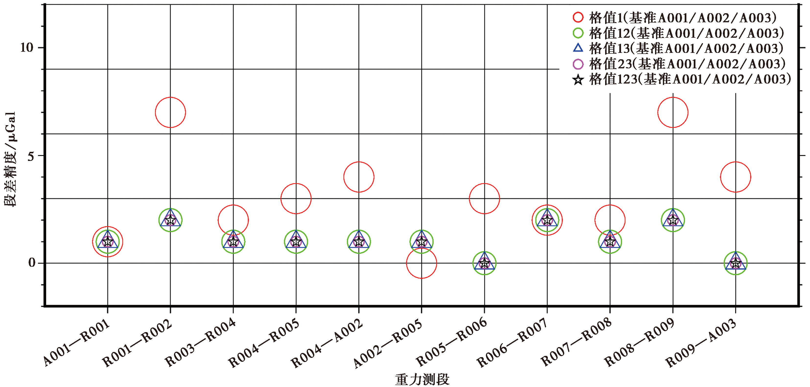
图2 A001/A002/A003基准下不同格值各测段的段差精度
Fig. 2 The accuracy of section difference corresponding to control benchmarks A001/A002/A003 and different scales.
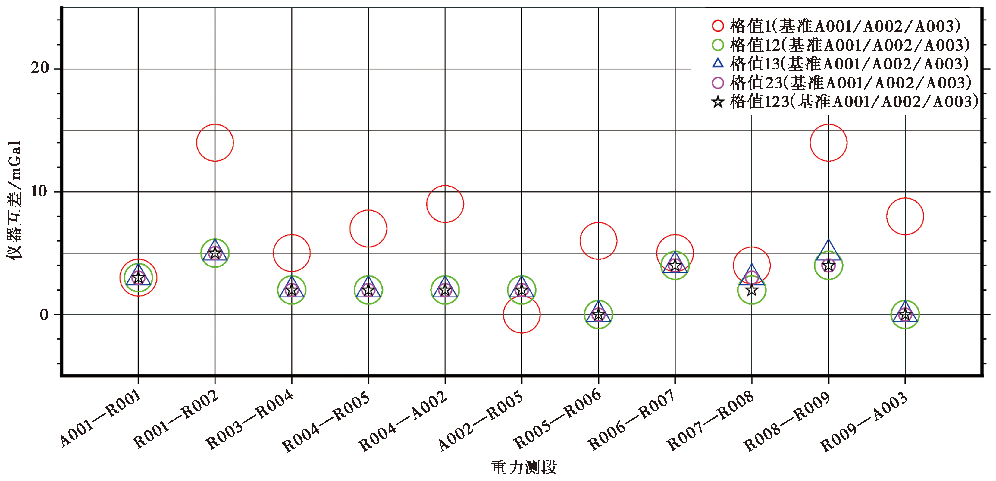
图3 A001/A002/A003基准下不同格值的仪器互差
Fig. 3 Mutual difference corresponding to control benchmarks A001/A002/A003 and different scales.
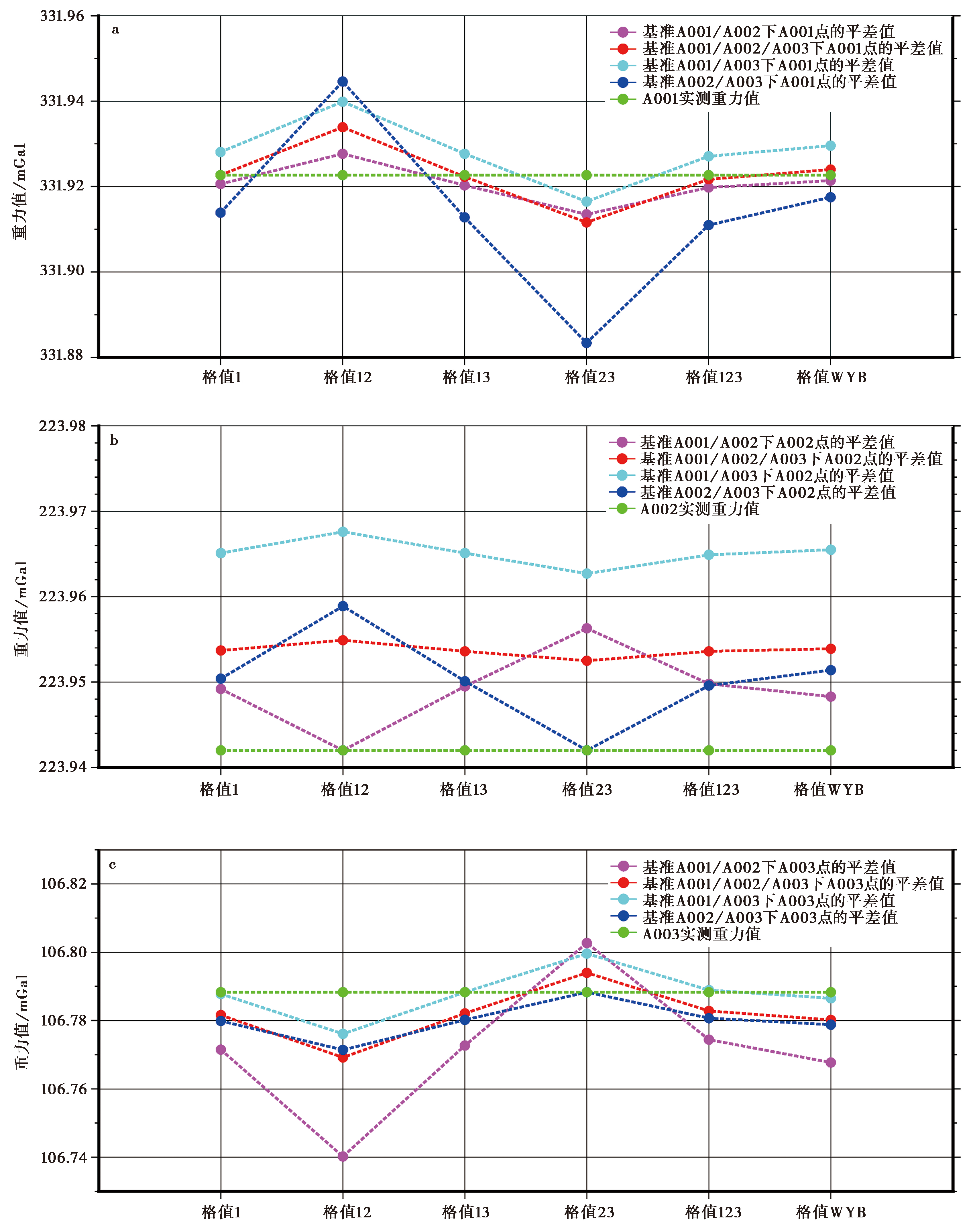
图4 不同格值和不同基准控制下解算的绝对重力基准控制点点值
Fig. 4 Gravity point values of absolute control points corresponding to different scales and control benchmarks.
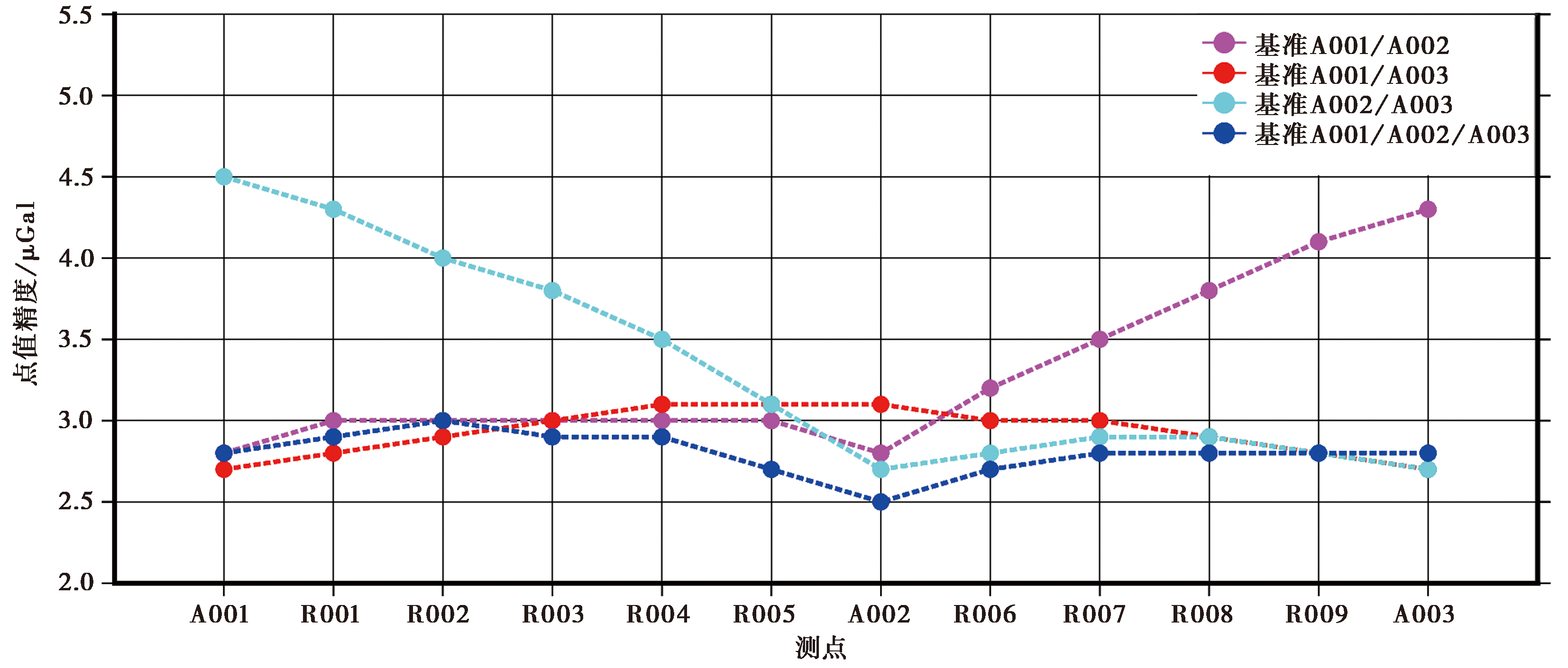
图5 “格值123”不同基准控制下解算的测点点值精度
Fig. 5 The accuracy of gravity point values corresponding to “scale 123” and different control benchmarks.
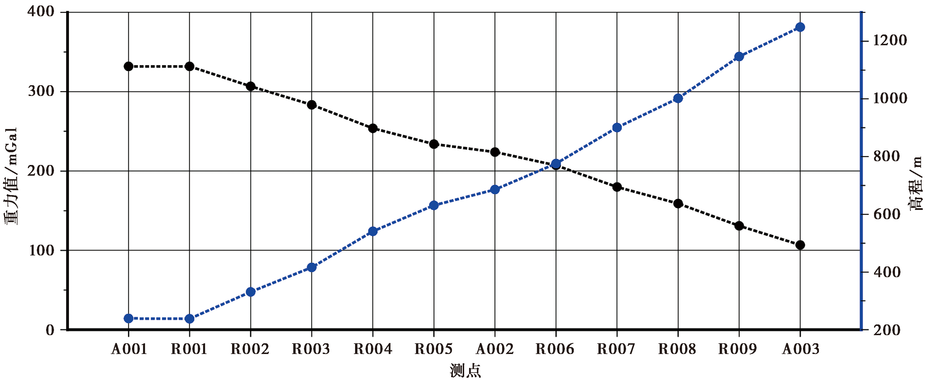
图6 金寨重力基线场点值与高程
Fig. 6 Gravity point value and elevation of Jinzhai gravity baseline.
| 仪器 | 仪器读数段 | |
|---|---|---|
| 金寨 | 武汉—宜昌—巴东 | |
| CG6-090 | 3272.900~3047.742 | 3291.990~3244.000~2862.000 |
| CG6-092 | 2990.124~2764.958 | 3009.292~2961.000~2579.000 |
表18 CG6-090/092重力仪器读数段范围
Table 18 The range of gravimeters CG6-090/092 reading section
| 仪器 | 仪器读数段 | |
|---|---|---|
| 金寨 | 武汉—宜昌—巴东 | |
| CG6-090 | 3272.900~3047.742 | 3291.990~3244.000~2862.000 |
| CG6-092 | 2990.124~2764.958 | 3009.292~2961.000~2579.000 |
| 仪器 | 格值 | 格值差值 | 格值差值对重力值的影响 | ||
|---|---|---|---|---|---|
| 金寨基线场格值123 | 武汉—宜昌—巴东格值WYB | 金寨基线场(225.1440mGal) | 安徽重力测网(400mGal) | ||
| CG6-090 | 1.000158 | 1.000186 | 0.000028 | 6.3 | 9.8 |
| CG6-092 | 0.999804 | 0.999862 | 0.000058 | 14.8 | 23.2 |
表19 同读数段格值差异对重力段差值影响(单位: μGal)
Table 19 The influence of section difference value by scale difference in the same reading section(unit: μGal)
| 仪器 | 格值 | 格值差值 | 格值差值对重力值的影响 | ||
|---|---|---|---|---|---|
| 金寨基线场格值123 | 武汉—宜昌—巴东格值WYB | 金寨基线场(225.1440mGal) | 安徽重力测网(400mGal) | ||
| CG6-090 | 1.000158 | 1.000186 | 0.000028 | 6.3 | 9.8 |
| CG6-092 | 0.999804 | 0.999862 | 0.000058 | 14.8 | 23.2 |
| [1] |
陈俊勇, 杨元喜, 王敏, 等. 2007. 2000国家大地控制网的构建和它的技术进步[J]. 测绘学报, 36(1): 1—8.
|
|
|
|
| [2] |
崔腾发, 陈小斌, 詹艳, 等. 2020. 安徽霍山地震区深部电性结构和发震构造特征[J]. 地球物理学报, 63(1): 256—269.
|
|
|
|
| [3] |
地壳运动监测工程研究中心. 2014. 地壳运动监测技术规程[M]. 北京: 中国环境出版社.
|
|
|
|
| [4] |
国家地震局. 1997. 地震重力测量规范[S]. 北京: 地震出版社.
|
|
State Seismological Bureau. 1997. Specification for Seismic Gravimetry[S]. Seismological Press, Beijing. (in Chinese)
|
|
| [5] |
郝洪涛, 李辉, 刘子维, 等. 2011. 基于重力差方法检测重力仪一次项格值系数变化[J]. 大地测量与地球动力学, 31(1): 87—90.
|
|
|
|
| [6] |
郝洪涛, 李辉, 孙和平, 等. 2016. CG-5重力仪零漂改正及格值系数检测应用研究[J]. 武汉大学学报(信息科学版), 41(9): 1265—1271.
|
|
|
|
| [7] |
郝洪涛, 王青华, 张新林, 等. 2022. 滇西地震预报实验场区重力长期变化特征及其机理[J]. 地震地质, 44(4): 876—894. doi: 10.3969/j.issn.0253-4967.2022.04.004.
|
|
|
|
| [8] |
胡敏章, 郝洪涛, 韩宇飞, 等. 2021. 2021年青海玛多 MS7.4 地震的重力挠曲均衡背景与震前重力变化[J]. 地球物理学报, 64(9): 3135—3149.
|
|
|
|
| [9] |
林伟, 王清晨,
|
|
DOI URL |
|
| [10] |
刘冬至. 1998. 绝对与相对重力同步比测中的拉科斯特重力仪标定[J]. 地壳形变与地震, 18(1): 88—94.
|
|
|
|
| [11] |
宁津生, 李建成, 罗志才, 等. 2002. 我国地球重力场研究的进展[J]. 东北测绘, 25(4): 6—9.
|
|
|
|
| [12] |
疏鹏, 路硕, 方良好, 等. 2018. 落儿岭-土地岭断裂几何结构及晚第四纪活动特征初探[J]. 震灾防御技术, 13(1): 87—97.
|
|
|
|
| [13] |
宋尚武, 王庆良, 郝明, 等. 2018. 大别山及其周边现今垂直形变研究[J]. 大地测量与地球动力学, 38(1): 32—35.
|
|
|
|
| [14] |
童劲松. 2008. 造山带岩浆作用与区域构造演化[D]. 北京: 中国地质大学.
|
|
|
|
| [15] |
汪健, 韩宇飞, 张新林, 等. 2020. 庐山重力基线场稳定性分析[J]. 中国地震, 36(4): 899—911.
|
|
|
|
| [16] |
王林海, 陈石, 庄建仓, 等. 2020. 精密重力测量中相对重力仪格值系数的贝叶斯估计方法[J]. 测绘学报, 49(12): 1543—1553.
DOI |
|
DOI |
|
| [17] |
王林松, 陈超, 杜劲松, 等. 2012. A10-022 绝对重力仪在庐山短基线的测量试验与分析[J]. 测绘学报, 41(3): 347—352.
|
|
|
|
| [18] |
王义天, 李继亮, 刘德良, 等. 2000. 大别山商城-麻城断裂带的40Ar-39Ar年龄及其意义[J]. 地质论评, 46(6): 611—615.
|
|
|
|
| [19] |
隗寿春, 祝意青, 赵云峰, 等. 2019. CG-5重力仪格值系数对重力数据处理的影响[J]. 大地测量与地球动力学, 39(2): 210—214.
|
|
|
|
| [20] |
邢乐林, 李辉, 李建国, 等. 2016. 陆态网络绝对重力基准的建立及应用[J]. 测绘学报, 45(5): 538—543.
DOI |
|
DOI |
|
| [21] |
杨锦玲, 陈石, 王林海, 等. 2021. 华南陆地时变重力观测数据质量评估[J]. 测绘学报, 50(3): 333—342.
DOI |
|
DOI |
|
| [22] |
杨元喜, 郭春喜, 刘念, 等. 2001. 绝对重力与相对重力混合平差的基准及质量控制[J]. 测绘工程, 10(2): 11—14.
|
|
|
|
| [23] |
袁鹏, 孙宏飞, 秦昌威, 等. 2016. 安徽CORS参考站三维速度场分析[J]. 武汉大学学报(信息科学版), 41(4): 535—540.
|
|
|
|
| [24] |
郑颖萍, 方良好, 舒鹏, 等. 2020. 合肥市活断层探测与地震危险性评价[M]. 北京: 科学出版社.
|
|
|
|
| [25] |
中华人民共和国国家市场监督管理局, 中国国家标准化管理委员会. 2019. 国家重力控制测量规范(GB/T20256-2019)[S]. 北京: 中国标准出版社.
|
|
State Administration for Market Regulation of the People's Republic of China, Standardization Administration of China. 2019. Specifications for the gravimetry control(GB/T20256-2019)[S]. Standards Press of China, Beijing. (in Chinese)
|
|
| [26] |
祝意青, 梁伟锋, 赵云峰, 等. 2017. 2017年四川九寨沟 MS7.0 地震前区域重力场变化[J]. 地球物理学报, 60(10): 4124—4131.
|
|
|
|
| [27] |
邹宗濂. 1991. 大别山东段重力场与深部构造新探[J]. 湖北地质, 5(2): 55—64.
|
|
|
|
| [28] |
DOI |
| [29] |
DOI URL |
| [30] |
|
| [31] |
DOI URL |
| [1] | 刘启元, Rainer Kind. 分离三分量远震接收函数的多道最大或然性反褶积方法[J]. 地震地质, 2004, 26(3): 416-425. |
| [2] | 杜建国, 张友联, 张建珍, 常永莲. 大别山榴辉岩的氦、氩同位素组成及其岩石成因[J]. 地震地质, 1999, 21(4): 431-435. |
| [3] | 姚大全, 汤有标, 刘加灿, 刘庆忠, 李杰, 王吉林, 翟洪涛. 大别山东北部基岩区断裂活动习性的综合研究[J]. 地震地质, 1999, 21(1): 63-68. |
| [4] | 杨坤光, 马昌前, 许长海, 杨巍然. 东大别山北缘姚河岩体与边部糜棱岩带的研究及其地质意义[J]. 地震地质, 1998, 20(4): 305-311. |
| [5] | 张家声, 周春平, 杨桂枝. 古震源实体初步研究[J]. 地震地质, 1992, 14(2): 165-175. |
| [6] | 马宝林. 桐柏山-大别山的地体构造特征和构造演化[J]. 地震地质, 1991, 13(1): 33-42. |
| [7] | 马宝林, 张兆忠. 大别山东段双变质带特征和古构造演化[J]. 地震地质, 1988, 10(2): 19-28. |
| 阅读次数 | ||||||
|
全文 |
|
|||||
|
摘要 |
|
|||||
