地震地质 ›› 2023, Vol. 45 ›› Issue (6): 1247-1264.DOI: 10.3969/j.issn.0253-4967.2023.06.001
沈柏1,2)( ), 张志亮1,2),*(), 任治坤1,2), 刘金瑞1,2)
收稿日期:2023-03-02
修回日期:2023-04-24
出版日期:2023-12-20
发布日期:2024-01-16
通讯作者:
张志亮, 男, 1987年生, 副研究员, 主要从事活动构造及晚新生代构造相关研究, E-mail: 作者简介:沈柏, 女, 1999年生, 2021年于常州大学获石油工程专业学士学位, 现为中国地震局地质研究所构造地质学专业在读硕士研究生, 主要研究方向为活动构造, E-mail: shenbai163@163.com。
基金资助:
SHEN Bai1,2)(), ZHANG Zhi-liang1,2),*(), REN Zhi-kun1,2), LIU Jin-rui1,2)
Received:2023-03-02
Revised:2023-04-24
Online:2023-12-20
Published:2024-01-16
摘要:
喀拉玉尔滚断裂是塔里木盆地北缘、 库车坳陷西边界的一条NW向右行走滑断裂, 同时也是库车坳陷和温宿凸起的分界断裂, 对其开展研究对于认识库车坳陷的构造变形具有重要意义, 但目前对该断裂的展布特征、 活动时间及形成机制仍存在较大争议。文中根据深部地球物理资料、 高分辨率遥感卫星影像解译, 并结合前人研究成果, 对该断裂进行了系统的研究工作。结果表明, 喀拉玉尔滚右行走滑断裂向N延伸穿过了阿瓦特背斜, 但其S向并未延伸至北喀背斜南部, 总体延伸约40km, 走滑断距约达4.1~4.3km。喀拉玉尔滚右行走滑断裂形成于上新世初期, 其活动可能一直持续至今, 但强度已明显减弱。喀拉玉尔滚断裂的形成除了受断裂两侧基底性质差异的控制外, 还与膏盐层的厚度差异密切相关。前者影响了断裂两侧地壳水平缩短量的差异, 从而导致新生代沉积盖层被撕裂; 后者在挤压应力的作用下影响盐上构造层的产生与演化, 进而影响断裂的形成。此外, 先期盐构造(盐底辟)的存在可能也对断裂的形成起到了重要作用。喀拉玉尔滚右行走滑断裂作为库车坳陷西部的边界断裂, 对其两侧甚至整个库车坳陷东、 西部地壳缩短量有一定的调节作用。同时, 断裂对南天山前陆盆地的地质地貌、 油气资源的运移与聚集也产生了显著影响。
沈柏, 张志亮, 任治坤, 刘金瑞. 库车坳陷西部喀拉玉尔滚断裂的活动时间、形成机制及其构造意义[J]. 地震地质, 2023, 45(6): 1247-1264.
SHEN Bai, ZHANG Zhi-liang, REN Zhi-kun, LIU Jin-rui. ACTIVITY PERIOD, FORMATION MECHANISM AND TECTONIC SIGNIFICANCE OF THE KALAYU’ERGUN FAULT IN THE WESTERN KUQA DEPRESSION[J]. SEISMOLOGY AND GEOLOGY, 2023, 45(6): 1247-1264.
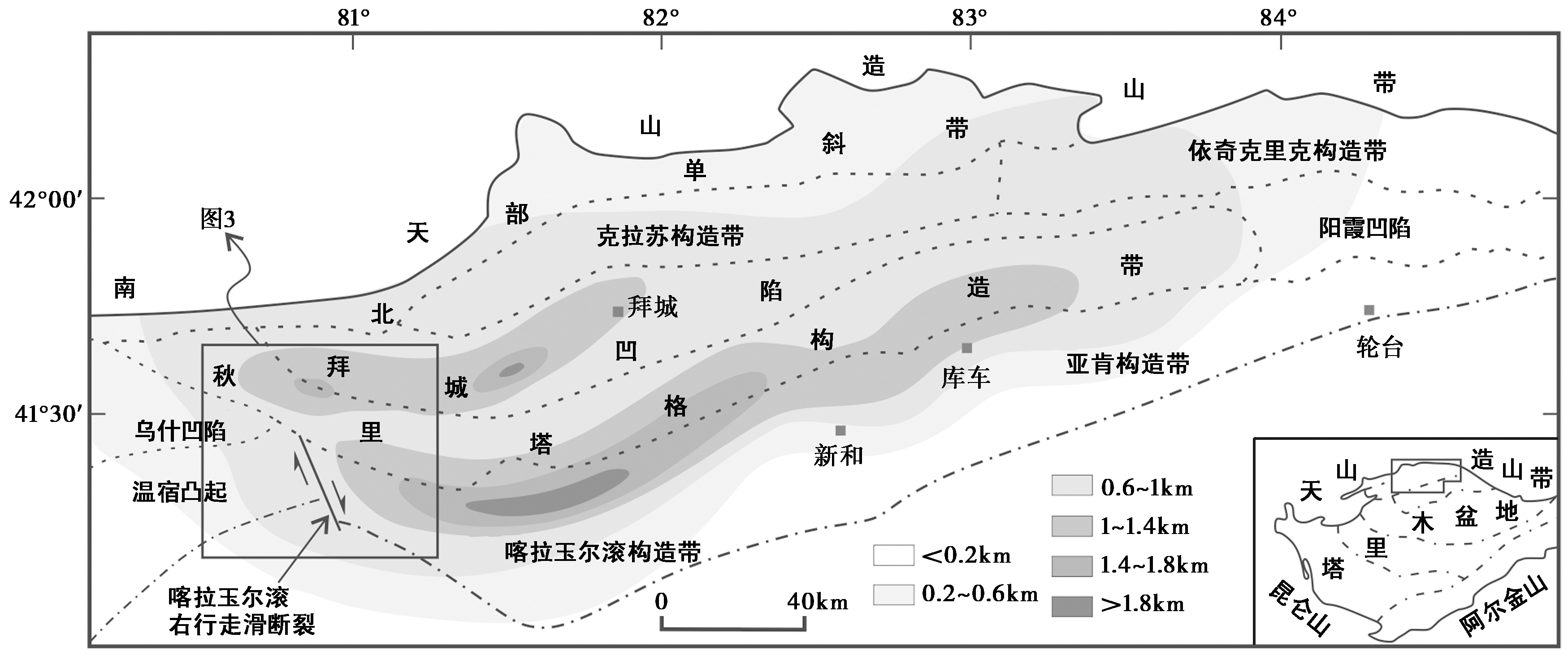
图1 库车坳陷的构造单元划分(据唐鹏程等, 2010; Zhang et al., 2019修改) 阴影部分代表坳陷内膏盐层的厚度
Fig. 1 Structural units of the Kuqa Depression (modified after TANG Peng-cheng et al., 2010; Zhang et al., 2019).
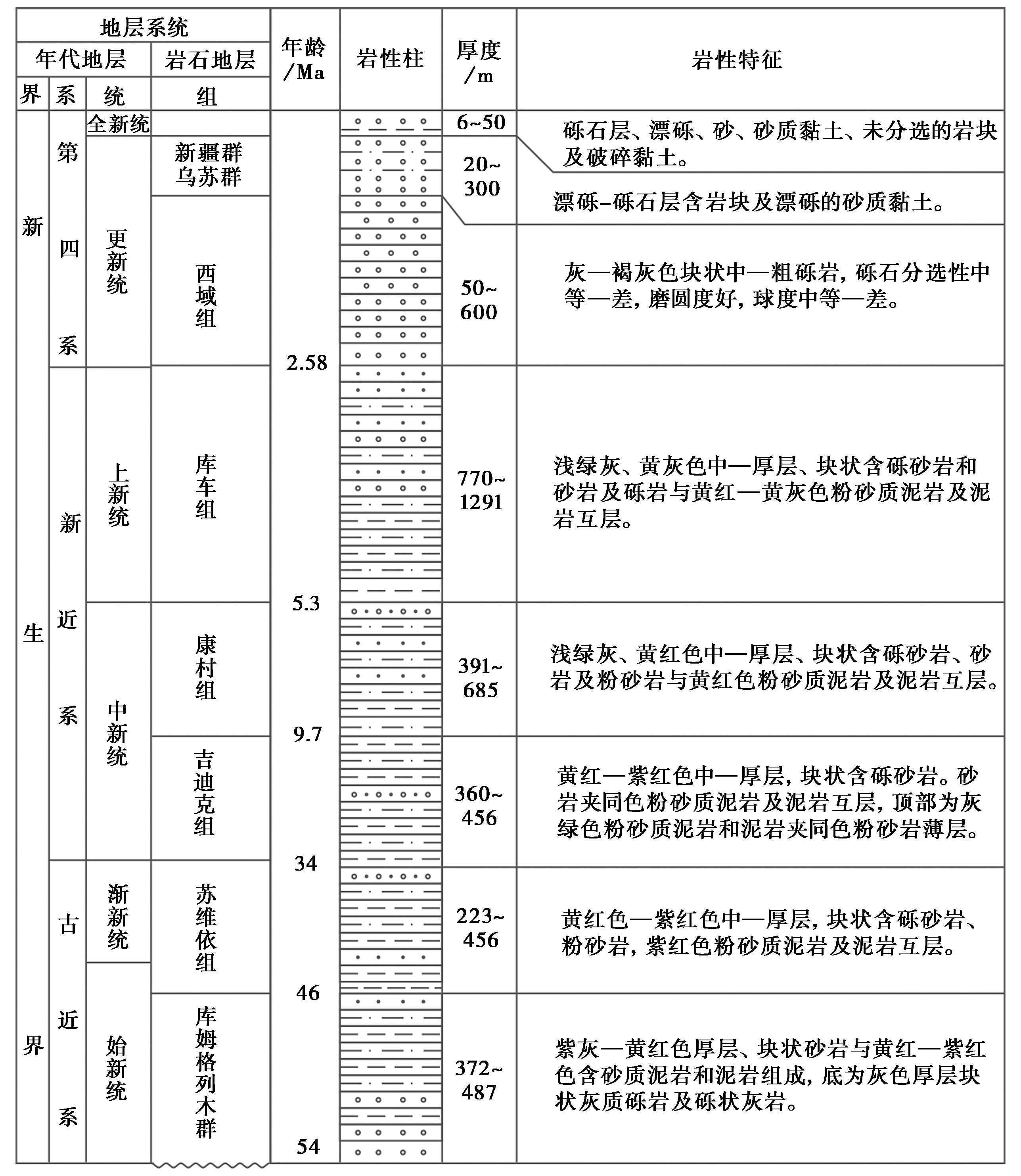
图2 库车褶皱-冲断带地层综合柱状图
Fig. 2 Comprehensive stratigraphic column in Kuqa fold-and-thrust belt.

图3 库车坳陷西部的数字高程模型图 KLYF 喀拉玉尔滚断裂; 底图为USGS SRTM 90m①(http://srtm.csi.cigar.org。)数字高程模型数据(DEM)…
Fig. 3 The digital elevation model(DEM)of the western part of Kuqa Depression.

图4 过北喀拉玉尔滚背斜的AA'测线解释剖面(根据Zhang et al., 2018修改) 测线位置见图 3
Fig. 4 AA' interpreted seismic section across the northern Kalayu’ergun anticline (modified after Zhang et al., 2018).

图5 过喀拉玉尔滚断裂的BB'、 CC'测线解释剖面(根据唐鹏程等, 2010修改) 测线位置见图 3
Fig. 5 BB', CC' interpreted seismic section across the Kalayu’ergun Fault (modified after TANG Peng-cheng et al., 2010).

图6 阿瓦特背斜北翼吸收缩短量的模式图
Fig. 6 The pattern diagram of the shortening absorbed by the northern flank of the Awat anticline.

图7 喀拉玉尔滚断裂附近的地震目录数据和震源机制解 地震数据源于中国地震台网中心; 震源机制解数据源于GCMT
Fig. 7 Earthquake catalog data and focal mechanism solutions near the Kalayu’ergun Fault.

图8 库车坳陷SN向缩短量的研究结果
Fig. 8 Results of the north-south-trending shortening in the Kuqa Depression.
| [1] |
安芷生, 王苏民, 吴锡浩, 等. 1998. 中国黄土高原的风积证据: 晚新生代北半球大冰期开始及青藏高原的隆升驱动[J]. 中国科学(D辑), 28(6): 481—490.
|
|
|
|
| [2] |
范湘涛, 卢华复, 郭华东, 等. 2000. 库车冲断带新构造遥感分析[J]. 地质论评, 46(5): 499—506.
|
|
|
|
| [3] |
管树巍, 汪新, 杨树锋, 等. 2004. 位移转换的2种概念模型与实例[J]. 中国科学(D辑), 34(9): 807—817.
|
|
|
|
| [4] |
郭召杰, 吴泰然, 王冬, 等. 2004. 塔里木西北缘晚新生代印干断层及其与帕米尔构造结的关系[J]. 自然科学进展, 14(9): 1072—1076.
|
|
|
|
| [5] |
何登发, 周新源, 杨海军, 等. 2009. 库车坳陷的地质结构及其对大油气田的控制作用[J]. 大地构造与成矿学, 33(1): 19—32.
|
|
|
|
| [6] |
何光玉, 赵庆, 李树新, 等. 2006. 塔里木库车盆地中生代原型分析[J]. 地质科学, 41(1): 44—53.
|
|
|
|
| [7] |
贺电, 李江海, 李百寿. 2009. 塔北喀拉玉尔滚断裂系构造特征及地质意义[J]. 北京大学学报(自然科学版), 45(1): 90—96.
|
|
|
|
| [8] |
贾承造, 魏国齐, 姚慧君, 等. 1995. 盆地构造演化与区域构造地质[M]. 北京: 石油工业出版社.
|
|
|
|
| [9] |
李百寿, 秦其明, 贺电, 等. 2007. 基于多空间分辨率遥感影像的喀拉玉尔滚构造带研究[J]. 地质科技情报, 26(5): 100—104, 108.
|
|
|
|
| [10] |
李世琴, 唐鹏程, 饶刚. 2013. 南天山库车褶皱-冲断带喀拉玉尔滚构造带新生代变形特征及其控制因素[J]. 地球科学, 38(4): 859—869.
|
|
|
|
| [11] |
李世琴, 汪新, 陈宁华. 2009. 南天山库车秋里塔格中段构造结变形特征和变形机理[J]. 地质科学, 44(3): 945—956.
|
|
|
|
| [12] |
李双建, 石永红, 王清晨, 等. 2007. 白垩纪以来库车坳陷碎屑重矿物组成变化[J]. 地质科学, 42(4): 709—721.
|
|
|
|
| [13] |
李双建, 王清晨, 李忠, 等. 2006. 砂岩碎屑组份变化对库车坳陷和南天山盆山演化的指示[J]. 地质科学, 41(3): 465—478.
|
|
|
|
| [14] |
李曰俊, 孙龙德, 吴浩若, 等. 2005. 南天山西端乌帕塔尔坎群发现石炭—二叠纪放射虫化石[J]. 地质科学, 40(2): 220—226.
|
|
|
|
| [15] |
李曰俊, 吴根耀, 雷刚林, 等. 2008. 新疆库车新生代前陆褶皱冲断带的变形特征、 时代和机制[J]. 地质科学, 43(3): 488—506.
|
| [16] |
|
| [17] |
李忠, 王清晨, 王道轩, 等. 2003. 晚新生代天山隆升与库车坳陷构造转换的沉积约束[J]. 沉积学报, 21(1): 38—45.
|
|
|
|
| [18] |
刘东生, 郑绵平, 郭正堂. 1998. 亚洲季风系统的起源和发展及其与两极冰盖和区域构造运动的时代耦合性[J]. 第四纪研究, 18(3): 194—204.
|
|
|
|
| [19] |
刘志宏, 卢华复, 李西建, 等. 2000. 库车再生前陆盆地的构造演化[J]. 地质科学, 35(4): 482—492.
|
|
|
|
| [20] |
苗继军, 贾承造, 王招明, 等. 2005. 塔里木盆地北部库车地区秋里塔格构造带地层结构及其对构造变形的制约[J]. 地质科学, 40(4): 558—569.
|
|
|
|
| [21] |
曲延军, 王海涛, 沈军. 2008. 天山地震带强震活动特征[J]. 内陆地震, 22(4): 289—297.
|
|
|
|
| [22] |
施雅风, 李吉均, 李炳元, 等. 1999. 晚新生代青藏高原的隆升与东亚环境变化[J]. 地理学报, 54(1): 10—21.
|
|
|
|
| [23] |
汤良杰, 李京昌, 余一欣, 等. 2006. 库车前陆褶皱-冲断带盐构造差异变形和分段性特征探讨[J]. 地质学报, 80(3): 313—320.
|
|
|
|
| [24] |
唐鹏程, 李世琴, 雷刚林, 等. 2012. 库车褶皱-冲断带拜城凹陷盐构造特征与成因[J]. 地球科学(中国地质大学学报), 37(1): 69—76, 92.
|
|
|
|
| [25] |
唐鹏程, 汪新, 谢会文, 等. 2010. 库车坳陷却勒地区新生代盐构造特征、 演化及变形控制因素[J]. 地质学报, 84(12): 1735—1745.
|
|
|
|
| [26] |
王清华, 杨明慧, 吕修祥. 2004. 库车褶皱冲断带秋里塔格构造带东、 西分段构造特征与油气聚集[J]. 地质科学, 39(4): 523—531.
|
|
|
|
| [27] |
王伟峰, 王乾, 单新建. 2018. 库车前陆冲断带横断层发育特征及其形成机制[J]. 中国地质, 45(3): 493—510.
|
|
|
|
| [28] |
王燮培, 严俊君. 1995. 塔里木盆地北部断裂格架分析[J]. 地球科学, 20(3): 237—242.
|
|
|
|
| [29] |
汪新, 贾承造, 杨树锋. 2002. 南天山库车褶皱冲断带构造几何学和运动学[J]. 地质科学, 37(3): 372—384.
|
|
|
|
| [30] |
王志勇, 程明华, 谷永兴, 等. 2009. 库车-喀什北缘山前带构造特征及成因分析[J]. 大地构造与成矿学, 33(1): 136—141.
|
|
|
|
| [31] |
吴根耀, 张洪安, 钱一雄, 等. 2012. 新疆塔里木库车冲断带东段更新世变形特征及其与西段的对比[J]. 第四纪研究, 32(5): 891—905.
|
|
|
|
| [32] |
新疆维吾尔自治区区域地层表编写组. 1993. 西北地区区域地层表: 新疆维吾尔自治区分册[M]. 北京: 地质出版社.
|
|
Regional Stratigraphic Scale of Xinjiang. 1993. Regional Stratigraphic Table of Northeast China: Xinjiang Province Volume[M]. Geological Publishing House, Beijing (in Chinese).
|
|
| [33] |
严俊君. 1996. 塔里木盆地北部NW向断裂的特征及地球动力学机制[J]. 地质论评, 42(S1): 116—123.
|
|
|
|
| [34] |
张光亚. 1997. 塔里木盆地北部构造转换形式及其成因[J]. 现代地质, 11(4): 452—460.
|
|
DOI URL |
|
| [35] |
郑民, 雷刚林, 黄少英, 等. 2007. 南天山西段南缘断裂构造特征及对乌什凹陷发育的控制[J]. 地质科学, 42(4): 639—655.
|
|
|
|
| [36] |
DOI URL |
| [37] |
DOI URL |
| [38] |
DOI URL |
| [39] |
DOI URL |
| [40] |
DOI URL |
| [41] |
PMID |
| [42] |
|
| [43] |
|
| [44] |
DOI URL |
| [45] |
PMID |
| [46] |
|
| [47] |
DOI URL |
| [48] |
DOI URL |
| [49] |
DOI URL |
| [50] |
|
| [51] |
DOI URL |
| [52] |
DOI URL |
| [53] |
DOI URL |
| [54] |
|
| [55] |
|
| [56] |
DOI URL |
| [1] | 周鑫, 周庆, 高帅坡. 1856年黔江咸丰地震(大路坝地震)崩滑体调查及其形成机制[J]. 地震地质, 2018, 40(2): 410-425. |
| [2] | 李胜强, 张玲, 杨晓平, 黄伟亮, 黄雄南, 杨海波. 库车坳陷东部秋里塔格背斜带的活动断层及其形成机制[J]. 地震地质, 2016, 38(2): 223-239. |
| [3] | 李安, 杨晓平, 黄伟亮, 伊力亚尔. 焉耆盆地北缘哈尔莫敦背斜区的活动断裂及其形成机制[J]. 地震地质, 2011, 33(4): 789-803. |
| [4] | 吴传勇, 沈军, 陈建波, 李军, 向志勇, 谢天, 宋正娜, 王翠. 新疆南天山库车坳陷晚第四纪以来地壳缩短速率的初步研究[J]. 地震地质, 2006, 28(2): 279-288. |
| [5] | 沈军, 吴传勇, 李军, 向志勇, 陈建波, 谢天, 宋正娜, 王翠. 库车坳陷活动构造的基本特征[J]. 地震地质, 2006, 28(2): 269-278. |
| [6] | 刘洁, 曲国胜, 童晓光, 宋惠珍, 周庆, 张宁. 库车坳陷深浅构造变形与地震关系浅析[J]. 地震地质, 2004, 26(2): 236-247. |
| [7] | 蒋靖祥, 尹光华, 温和平, 余建和. 库车坳陷的地震孕震环境初探[J]. 地震地质, 2002, 24(3): 346-354. |
| [8] | 赵瑞斌, 杨主恩, 周伟新, 郭芳. 天山南北两侧山前坳陷带中新生代构造特征与地震[J]. 地震地质, 2000, 22(3): 295-304. |
| [9] | 虢顺民, 向宏发, 徐锡伟, 张晚霞, 周瑞琦, 董兴权. 滇西南龙陵-澜沧第四纪新生断裂带特征和形成机制研究[J]. 地震地质, 2000, 22(3): 277-284. |
| [10] | 虢顺民, 江在森, 张崇立. 青藏高原东北缘晚第四纪块体划分与运动态势研究[J]. 地震地质, 2000, 22(3): 219-231. |
| [11] | 罗焕炎, 孔祥红, 高维安. 山西断陷盆地带形成机制的初步数值模拟[J]. 地震地质, 1988, 10(1): 71-77. |
| 阅读次数 | ||||||
|
全文 |
|
|||||
|
摘要 |
|
|||||
