地震地质 ›› 2026, Vol. 48 ›› Issue (5): 1231-1252.DOI: 10.3969/j.issn.0253-4967.20260025
闫成国1)( ), 王志胜1), 张文朋1), 胥勤勉2), 高武平1), 杨菲1), 安立强1)
收稿日期:2026-02-27
修回日期:2026-05-15
出版日期:2026-11-11
发布日期:2026-11-11
作者简介:闫成国, 男, 1982年生, 2007年于中国地震局地壳应力研究所获固体地球物理专业硕士学位, 高级工程师, 现主要从事华北平原区隐伏断裂探测研究工作, E-mail: yanchg2004@163.com。
基金资助:
YAN Cheng-guo1)(), WANG Zhi-sheng1), ZHANG Wen-peng1), XU Qin-mian2), GAO Wu-ping1), YANG Fei1), AN Li-qiang1)
Received:2026-02-27
Revised:2026-05-15
Online:2026-11-11
Published:2026-11-11
摘要:
潮白河断裂是张家口-渤海断裂带的重要组成断裂。文中通过深地震反射剖面探测、浅层地震勘探及钻孔联合地质剖面探测相结合的方法对该断裂的深浅构造关系进行了刻画, 对断裂晚第四纪以来的活动性进行了研究。探测结果表明, 潮白河断裂走向NW, 展布于天津宝坻至宁河一带, 夹于宝坻断裂和沧东断裂之间, 长约40km, 分为南、北2段, 南段与北段倾向相反, 表现出枢纽断裂的特性。深反射剖面显示, 潮白河断裂是箕状沉积凹陷的主控边界断裂, 向下错断了新近系底界、古近系底界及结晶基底, 并延入中下地壳, 新近系底界断距为320~380m, 古近系在下降盘沉积厚约2 350m, 而在上升盘则缺失; 潮白河断裂下方存在错断莫霍面的深大断裂, 断裂成因主要是上地幔隆起引起的地壳垂直运动。钻孔联合地质剖面显示, 潮白河断裂的上断点埋深至少已达12.95m, 为全新世活动断裂; 断裂北段下盘埋深72.85m处的地层累积垂直位移为26.85m, 可能发生了16次地震事件, 平均同震位移量为1.68m, 晚更新世以来累积垂直位移为16.8m, 约发生了10次地震事件, 同震位移量在1.2~1.9m之间, 均值为1.68m; 断裂南段下盘埋深86.2m处的地层累积垂直位移为21.2m, 可能发生了14次地震事件, 同震位移量在1.1~1.88m之间, 均值为1.51m。
闫成国, 王志胜, 张文朋, 胥勤勉, 高武平, 杨菲, 安立强. 天津潮白河断裂深浅部构造特征及晚第四纪活动性[J]. 地震地质, 2026, 48(5): 1231-1252.
YAN Cheng-guo, WANG Zhi-sheng, ZHANG Wen-peng, XU Qin-mian, GAO Wu-ping, YANG Fei, AN Li-qiang. STUDY ON THE DEEP-SHALLOW STRUCTURE CHARAC-TERISTICS AND THE LATE QUATERNARY ACTIVITY OF THE CHAOBAIHE FAULT IN TIANJIN[J]. SEISMOLOGY AND GEOLOGY, 2026, 48(5): 1231-1252.
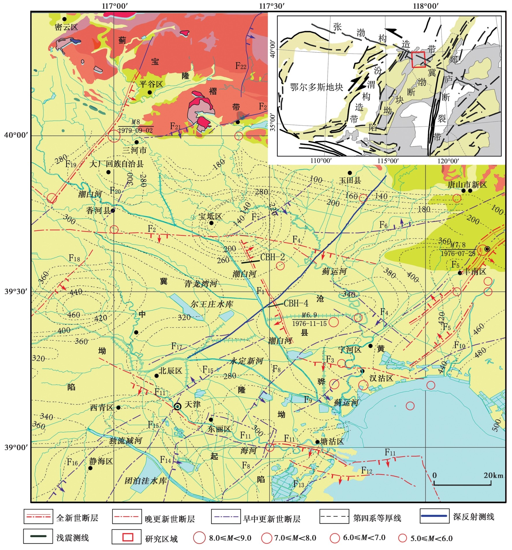
图1 研究区地震构造及主要断裂分布图 F1潮白河断裂; F2宝坻断裂; F3汉沽断裂; F4蓟运河断裂; F5唐山断裂带; F6丰台-野鸡坨断裂; F7工部断裂; F8沧东断裂; F9茶淀断裂; F10宁河-昌黎断裂; F11海河断裂; F12长芦-歧北断裂; F13大张坨断裂; F14大寺断裂; F15天津北断裂; F16天津南断裂; F17汉沟断裂; F18河西务断裂; F19夏垫断裂; F20香河断裂; F21蓟县山前断裂; F22黄崖关断裂
Fig. 1 The distribution of seismotectonic and main faults in the study area.
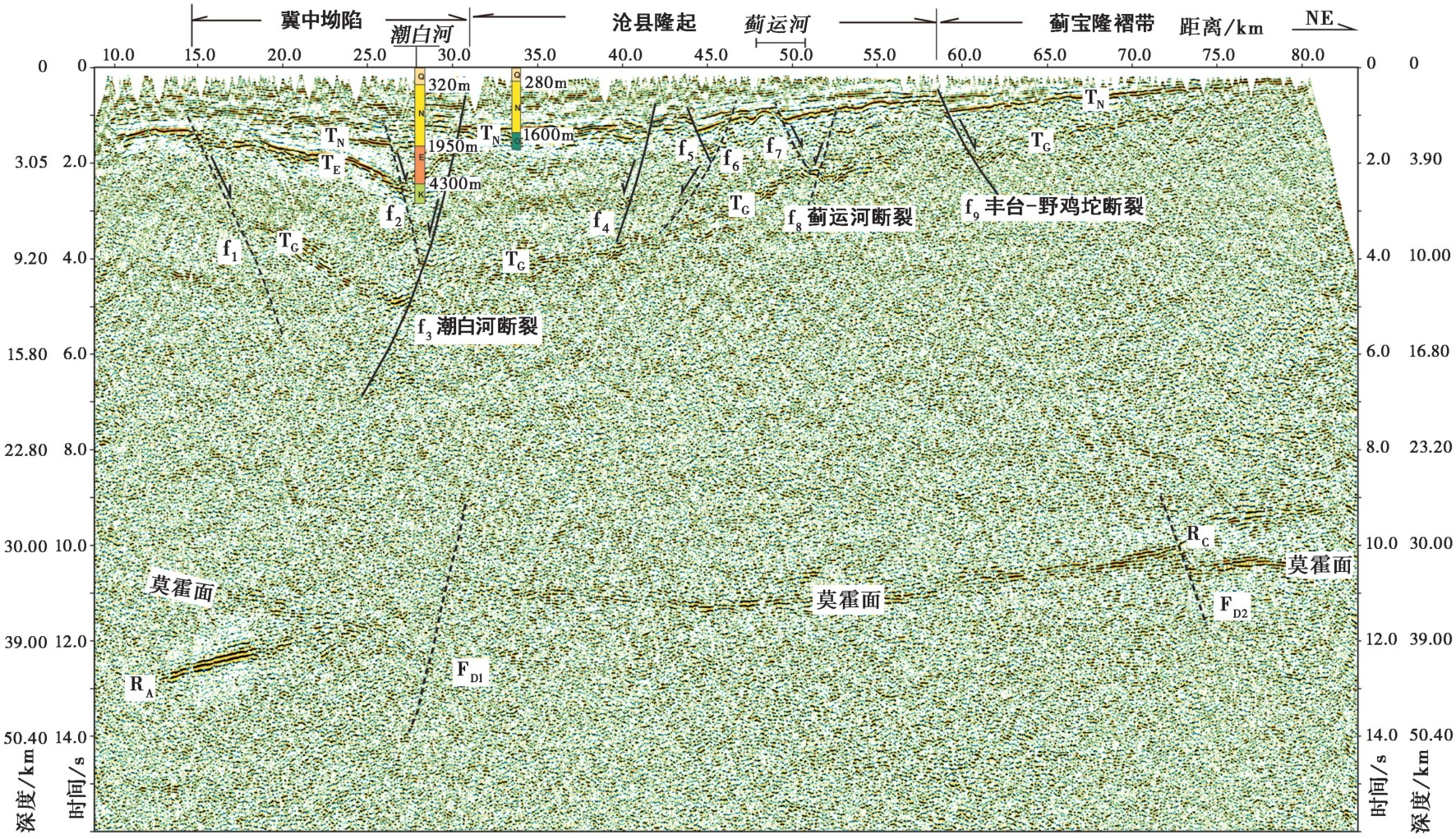
图2 跨潮白河断裂的深地震反射剖面(闫成国等,2020)
Fig. 2 Deep seismic reflection profile across the Chaobaihe Fault(YAN Cheng-guo et al., 2020).
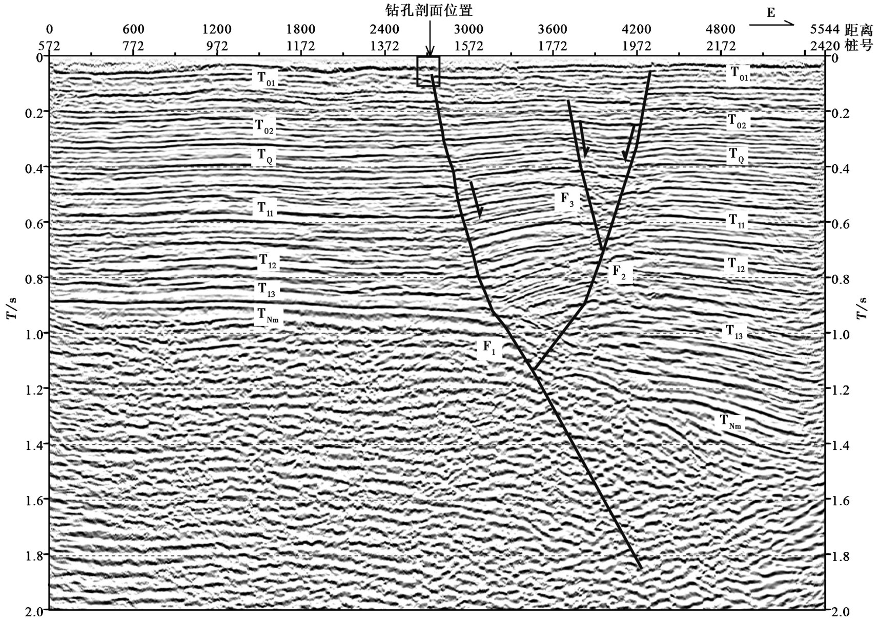
图3 CBH-2浅层地震反射时间解释剖面
Fig. 3 Shallow seismic reflection time interpretation profile of line CBH-2.
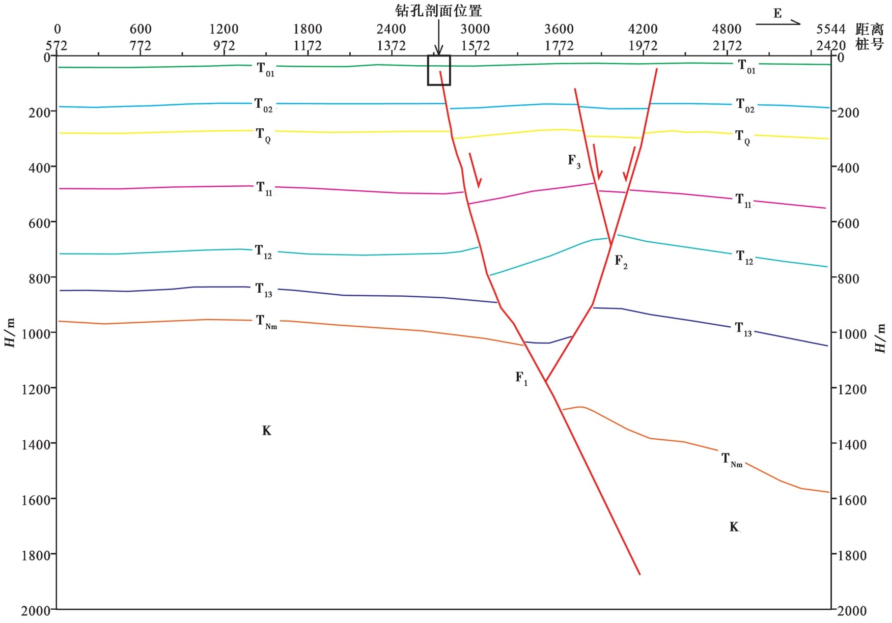
图4 CBH-2浅层地震地质解释剖面
Fig. 4 Shallow seismic reflection geological interpretation profile of line CBH-2.
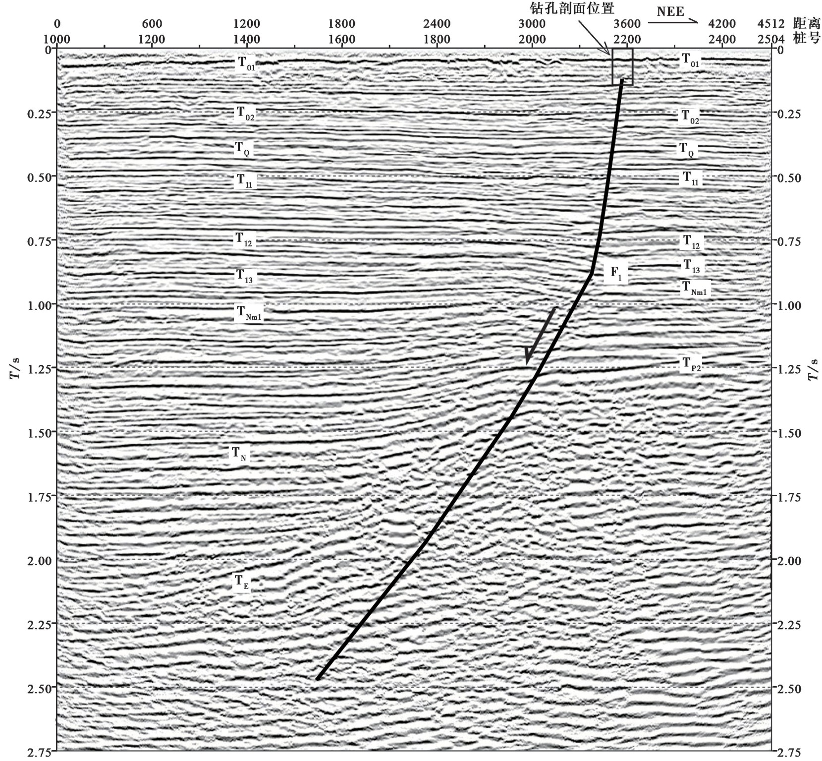
图5 CBH-4浅层地震反射时间解释剖面
Fig. 5 Shallow seismic reflection time interpretation profile of line CBH-4.
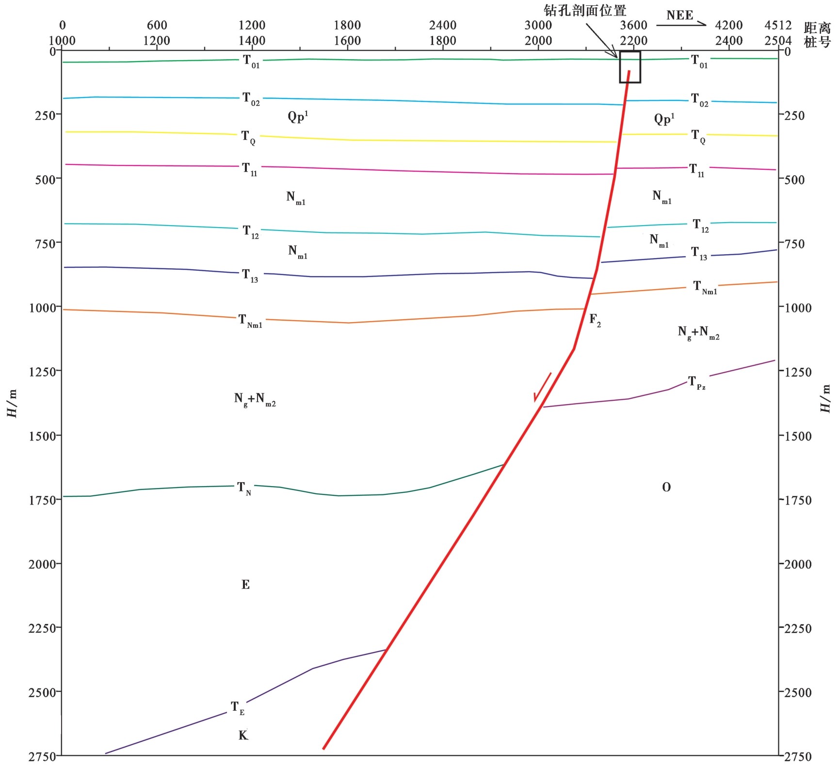
图6 CBH-4浅层地震地质解释剖面
Fig. 6 Shallow seismic reflection geological interpretation profile of line CBH-4.
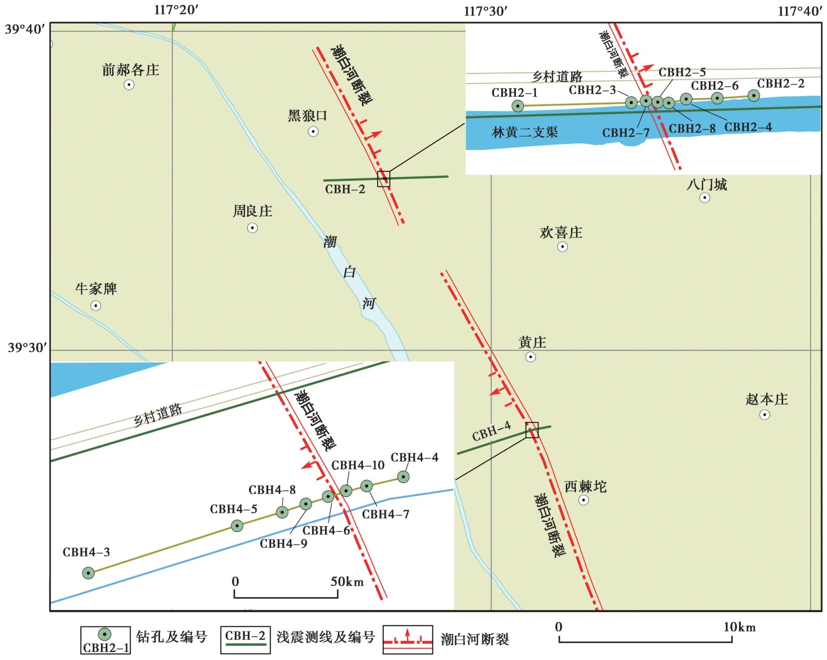
图7 跨潮白河断裂钻孔联合地质剖面位置图
Fig. 7 Location map of the joint-drilling geologic section across the Chaobaihe Fault.
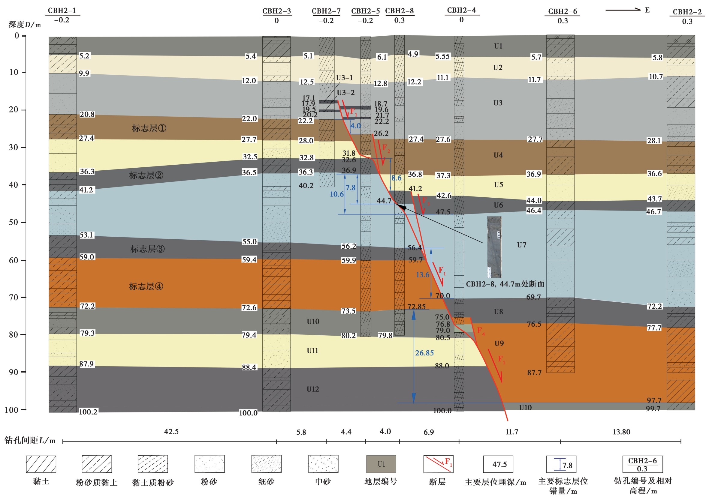
图8 跨潮白河断裂CBH-2钻孔联合地质剖面图
Fig. 8 Joint drilling geologic section of line CBH-2 across the Chaobaihe Fault.
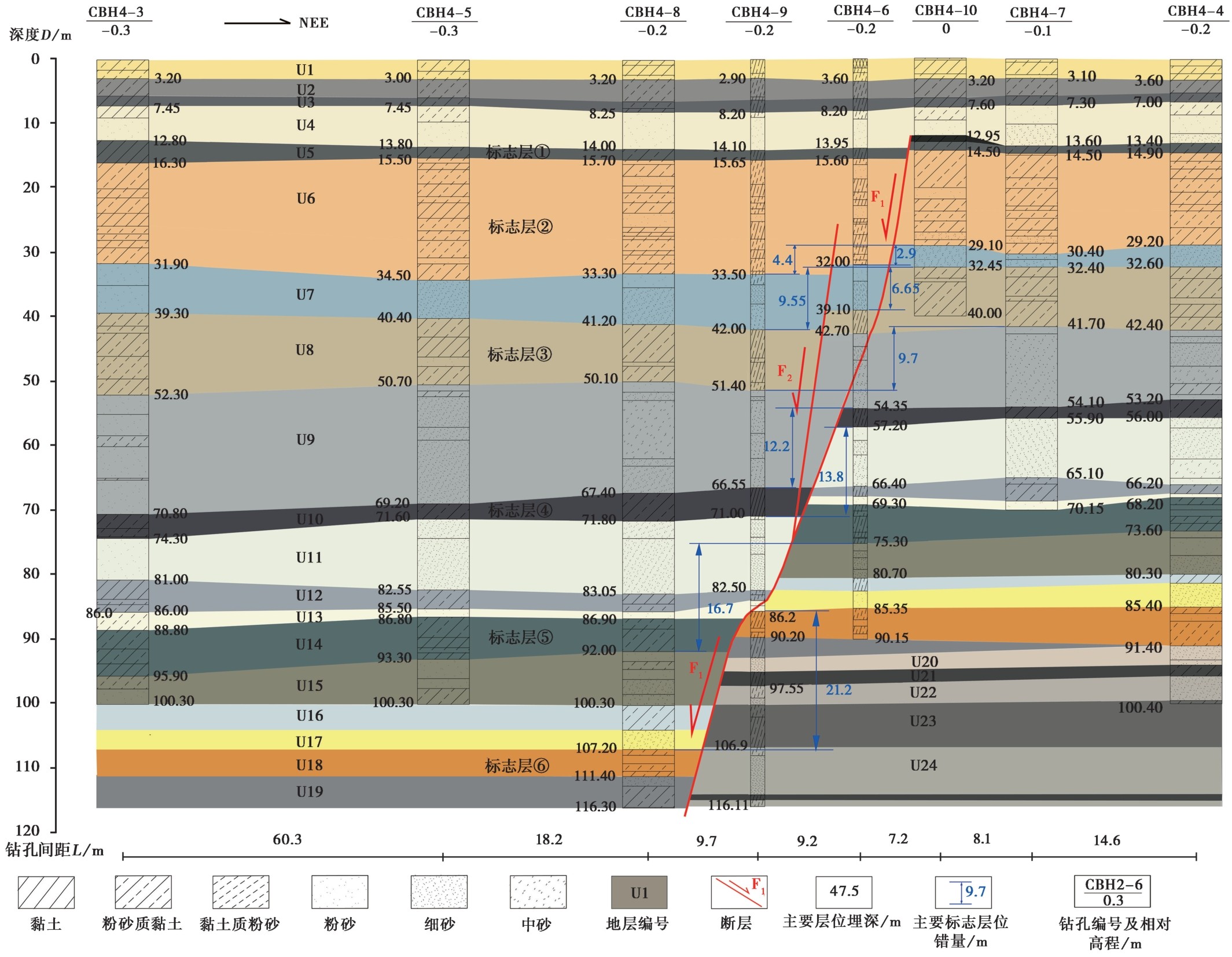
图9 跨潮白河断裂CBH-4钻孔联合地质剖面图
Fig. 9 Joint drilling geologic section of line CBH-4 across the Chaobaihe Fault.
| 地层 编号 | 主断层F1 | 次级断层F2 | 次级断层F3 | 次级断层F4 | 累积位移量/m | 地震事件及 同震位移 /m | |||||||||||||
|---|---|---|---|---|---|---|---|---|---|---|---|---|---|---|---|---|---|---|---|
| 顶界或底界深度 /m | 位移量/m | 地震事件及 同震位移 /m | 顶界或底 界深度/m | 位移量/m | 地震事件 及同震位移 /m | 顶界或底 界深度/m | 位移量/m | 地震事 件及同 震位移 | 顶界或底 界深度/m | 位移量/m | 地震事件 及同震 位移/m | ||||||||
| 界面 | 下盘 | 上盘 | 下盘 | 上盘 | 下盘 | 上盘 | 下盘 | 上盘 | |||||||||||
| U3-1 | 顶界 | 17.1 | 18.7 | 1.6 | E1,D1=1.9 (取顶底界 位移量均值) | 1.6 | E1,D1=1.9 (取顶底界 位移量均值) | ||||||||||||
| 底界 | 17.9 | 19.6 | 1.7 | 1.7 | |||||||||||||||
| U3-2 | 顶界 | 19.5 | 21.7 | 2.2 | 2.2 | ||||||||||||||
| 底界 | 20.2 | 22.2 | 2.0 | 2.0 | |||||||||||||||
| U4 | 顶界 | 22.2 | 26.2 | 4.0 | E2,D2=1.9 D1+D2=3.8 | 26.2 | 27.4 | 1.2 | E3,D3=1.2 | 5.2 | E1-E3, D1+D2+D3=5.0 | ||||||||
| 底界 | 28.0 | 31.8 | 3.8 | 31.8 | 36.8 | 5.0 | E4,D4=1.9 E5, D5=1.9 D3+D4+D5=5.0 | 8.8 | E1-E5, D1+…+D5=8.8 | ||||||||||
| U6 | 顶界 | 32.6 | 41.2 | 8.6 | E1-E5, D1+…+D5=8.8 | 41.2 | 42.6 | 1.4 | E6, D6=1.8 | 10.0 | E1-E6, D1+…+D6=10.6 | ||||||||
| 底界 | 36.9 | 44.7 | 7.8 | 44.7 | 47.5 | 2.8 | 10.6 | ||||||||||||
| U8 | 顶界 | 56.4 | 70.0 | 13.6 | E7,D7=1.5 E8, D8=1.5 E1-E8,D1+… +D8=13.6 | 13.6 | E1-E8, D1+…+D8=13.6 | ||||||||||||
| 底界 | 59.7 | 75.0 | 15.3 | E9,D9=1.7 E1-E9,D1+… +D9=15.3 | 75.0 | 76.5 | 1.5 | E10, D10=1.5 | 16.8 | E1-E10, D1+…+D10=16.8 | |||||||||
| U9 | 顶界 | 59.7 | 75.0 | 15.3 | E11,D11=1.68 …… E16, D16=1.68 E1-E16,D1+… +D16=26.85 | 75.0 | 76.5 | 1.5 | 16.8 | E1-E16, D1+…+D16 =26.85 | |||||||||
| 底界 | 72.85 | 99.7 | 26.85 | 26.85 | |||||||||||||||
表1 跨潮白河断裂CBH-2钻孔联合地质剖面主要标志层断错位移量及地震事件简表
Table1 The brief table of the fault displacement of the main horizons and seismic events in the joint drilling geologic section of line CBH-2 crossing the Chaobaihe Fault
| 地层 编号 | 主断层F1 | 次级断层F2 | 次级断层F3 | 次级断层F4 | 累积位移量/m | 地震事件及 同震位移 /m | |||||||||||||
|---|---|---|---|---|---|---|---|---|---|---|---|---|---|---|---|---|---|---|---|
| 顶界或底界深度 /m | 位移量/m | 地震事件及 同震位移 /m | 顶界或底 界深度/m | 位移量/m | 地震事件 及同震位移 /m | 顶界或底 界深度/m | 位移量/m | 地震事 件及同 震位移 | 顶界或底 界深度/m | 位移量/m | 地震事件 及同震 位移/m | ||||||||
| 界面 | 下盘 | 上盘 | 下盘 | 上盘 | 下盘 | 上盘 | 下盘 | 上盘 | |||||||||||
| U3-1 | 顶界 | 17.1 | 18.7 | 1.6 | E1,D1=1.9 (取顶底界 位移量均值) | 1.6 | E1,D1=1.9 (取顶底界 位移量均值) | ||||||||||||
| 底界 | 17.9 | 19.6 | 1.7 | 1.7 | |||||||||||||||
| U3-2 | 顶界 | 19.5 | 21.7 | 2.2 | 2.2 | ||||||||||||||
| 底界 | 20.2 | 22.2 | 2.0 | 2.0 | |||||||||||||||
| U4 | 顶界 | 22.2 | 26.2 | 4.0 | E2,D2=1.9 D1+D2=3.8 | 26.2 | 27.4 | 1.2 | E3,D3=1.2 | 5.2 | E1-E3, D1+D2+D3=5.0 | ||||||||
| 底界 | 28.0 | 31.8 | 3.8 | 31.8 | 36.8 | 5.0 | E4,D4=1.9 E5, D5=1.9 D3+D4+D5=5.0 | 8.8 | E1-E5, D1+…+D5=8.8 | ||||||||||
| U6 | 顶界 | 32.6 | 41.2 | 8.6 | E1-E5, D1+…+D5=8.8 | 41.2 | 42.6 | 1.4 | E6, D6=1.8 | 10.0 | E1-E6, D1+…+D6=10.6 | ||||||||
| 底界 | 36.9 | 44.7 | 7.8 | 44.7 | 47.5 | 2.8 | 10.6 | ||||||||||||
| U8 | 顶界 | 56.4 | 70.0 | 13.6 | E7,D7=1.5 E8, D8=1.5 E1-E8,D1+… +D8=13.6 | 13.6 | E1-E8, D1+…+D8=13.6 | ||||||||||||
| 底界 | 59.7 | 75.0 | 15.3 | E9,D9=1.7 E1-E9,D1+… +D9=15.3 | 75.0 | 76.5 | 1.5 | E10, D10=1.5 | 16.8 | E1-E10, D1+…+D10=16.8 | |||||||||
| U9 | 顶界 | 59.7 | 75.0 | 15.3 | E11,D11=1.68 …… E16, D16=1.68 E1-E16,D1+… +D16=26.85 | 75.0 | 76.5 | 1.5 | 16.8 | E1-E16, D1+…+D16 =26.85 | |||||||||
| 底界 | 72.85 | 99.7 | 26.85 | 26.85 | |||||||||||||||
| 地层 编号 | 主断层F1 | 次级断层F2 | 累积位移量/m | 地震事件及 同震位移 /m | |||||||
|---|---|---|---|---|---|---|---|---|---|---|---|
| 顶界或底界深度 /m | 位移量/m | 地震事件及 同震位移 /m | 顶界或底 界深度/m | 位移量/m | 地震事件 及同震位移 /m | ||||||
| 界面 | 下盘 | 上盘 | 下盘 | 上盘 | |||||||
| U5 | 顶界 | 12.95 | 13.95 | 1.0 | E1,D1=1.1 | 1.0 | E1,D1=1.1 | ||||
| 底界 | 14.5 | 15.6 | 1.1 | 1.1 | |||||||
| U6 | 顶界 | 14.5 | 15.6 | 1.1 | 1.1 | ||||||
| 底界 | 29.1 | 32.0 | 2.9 | E2,D2=1.8 D1+2=2.9 | 32.0 | 33.5 | 1.5 | E3,D3=1.5 | 4.4 | E1~E3 D1+D2+D3=4.4 | |
| U8 | 顶界 | 32.45 | 39.1 | 6.65 | E4,D4=1.88 E5, D5=1.88 D1+D2+D4+D5=6.65 | 39.1 | 42.0 | 2.9 | E6,D6=1.4 D3+D6=2.9 | 9.55 | E1-E6 D1+…+D6=9.55 |
| 底界 | 41.7 | 51.4 | 9.7 | ||||||||
| U10 | 顶界 | 54.35 | 66.55 | 12.2 | E7,D7=1.25 E8, D8=1.25 D1+…+D8=12.05 | 12.2 | E1-E8 D1+…D8=12.05 | ||||
| 底界 | 57.2 | 71.0 | 13.8 | E9,D9=1.6 D1+…+D9=13.65 | 13.8 | E1-E9 D1+…D9=13.65 | |||||
| U14 | 顶界 | 69.3 | 86.9 | 17.6 | E10,D10=1.45 E11, D11=1.45 D1+…+D11=16.55 | 17.6 | E1-E11 D1+…D11=16.55 | ||||
| 底界 | 75.3 | 92.0 | 16.7 | 16.7 | |||||||
| U18 | 顶界 | 86.2 | 107.2 | 21.0 | E12,D12=1.5 E13, D13=1.5 E14, D14=1.5 D1+…+D14=21.05 | 21.0 | E1-E14 D1+…D11=21.05 | ||||
| 底界 | 90.2 | 111.1 | 21.2 | 21.2 | |||||||
表2 跨潮白河断裂CBH-4钻孔联合地质剖面主要标志层断错位移量及地震事件简表
Table2 The brief table of the fault displacement of the main horizons and seismic events in the joint drilling geologic section of line CBH-4 crossing the Chaobaihe Fault
| 地层 编号 | 主断层F1 | 次级断层F2 | 累积位移量/m | 地震事件及 同震位移 /m | |||||||
|---|---|---|---|---|---|---|---|---|---|---|---|
| 顶界或底界深度 /m | 位移量/m | 地震事件及 同震位移 /m | 顶界或底 界深度/m | 位移量/m | 地震事件 及同震位移 /m | ||||||
| 界面 | 下盘 | 上盘 | 下盘 | 上盘 | |||||||
| U5 | 顶界 | 12.95 | 13.95 | 1.0 | E1,D1=1.1 | 1.0 | E1,D1=1.1 | ||||
| 底界 | 14.5 | 15.6 | 1.1 | 1.1 | |||||||
| U6 | 顶界 | 14.5 | 15.6 | 1.1 | 1.1 | ||||||
| 底界 | 29.1 | 32.0 | 2.9 | E2,D2=1.8 D1+2=2.9 | 32.0 | 33.5 | 1.5 | E3,D3=1.5 | 4.4 | E1~E3 D1+D2+D3=4.4 | |
| U8 | 顶界 | 32.45 | 39.1 | 6.65 | E4,D4=1.88 E5, D5=1.88 D1+D2+D4+D5=6.65 | 39.1 | 42.0 | 2.9 | E6,D6=1.4 D3+D6=2.9 | 9.55 | E1-E6 D1+…+D6=9.55 |
| 底界 | 41.7 | 51.4 | 9.7 | ||||||||
| U10 | 顶界 | 54.35 | 66.55 | 12.2 | E7,D7=1.25 E8, D8=1.25 D1+…+D8=12.05 | 12.2 | E1-E8 D1+…D8=12.05 | ||||
| 底界 | 57.2 | 71.0 | 13.8 | E9,D9=1.6 D1+…+D9=13.65 | 13.8 | E1-E9 D1+…D9=13.65 | |||||
| U14 | 顶界 | 69.3 | 86.9 | 17.6 | E10,D10=1.45 E11, D11=1.45 D1+…+D11=16.55 | 17.6 | E1-E11 D1+…D11=16.55 | ||||
| 底界 | 75.3 | 92.0 | 16.7 | 16.7 | |||||||
| U18 | 顶界 | 86.2 | 107.2 | 21.0 | E12,D12=1.5 E13, D13=1.5 E14, D14=1.5 D1+…+D14=21.05 | 21.0 | E1-E14 D1+…D11=21.05 | ||||
| 底界 | 90.2 | 111.1 | 21.2 | 21.2 | |||||||
| [1] |
邓起东, 闵伟, 晁洪太, 等. 2001. 渤海地区新生代构造与地震活动[G]//卢演俦, 高维明, 陈国星, 等. 新构造与环境. 北京: 地震出版社: 218-233.
|
|
|
|
| [2] |
高文学, 马瑾. 1993. 首都圈地震地质环境与地震灾害[M]. 北京: 地震出版社.
|
|
|
|
| [3] |
国家地震局《一九七六年唐山地震》编辑组. 1982. 一九七六年唐山地震[M]. 北京: 地震出版社.
|
|
State Seismological Bureau《Tangshan Earthquake》Editorial Group. 1982. 1976 Tangshan Earthquake[M]. Seismological Press, Beijing (in Chinese).
|
|
| [4] |
虢顺民, 李志义, 程绍平, 等. 1977. 唐山地震区域构造背景和发震模式的讨论[J]. 地质科学, (4): 305-321.
|
|
|
|
| [5] |
黄猛, 韩荣文, 牛毅, 等. 2021. 渤海湾西北岸MIS3阶段以来的海侵特征[J]. 地质通报, 40(5): 721-733.
|
|
|
|
| [6] |
黄猛, 李明辰, 樊航宇, 等. 2019. 渤海湾西北岸QHJ01孔记录的晚新生代气候与沉积环境演化[J]. 地质学报, 93(4): 899-914.
|
|
|
|
| [7] |
江娃利, 侯治华, 肖振敏, 等. 2000. 北京平原夏垫断裂齐心庄探槽古地震事件分析[J]. 地震地质, 22(4): 413-422.
|
|
|
|
| [8] |
江娃利, 侯治华, 谢新生. 2001. 北京平原南口-孙河断裂带昌平旧县探槽古地震事件研究[J]. 中国科学(D辑), 31(6): 501-509.
|
|
|
|
| [9] |
李正芳, 李彦宝, 周本刚, 等. 2021. 北京平原大兴凸起东缘断裂全新世活动的新认识[J]. 地震地质, 43(6): 1671-1681. doi: 10.3969/j.issn.0253-4967.2021.06.018.
|
|
DOI |
|
| [10] |
马瑾, 张渤涛, 袁淑荣. 1980. 唐山地震与地震危险区[J]. 地震地质, 2(2): 43-54.
|
|
|
|
| [11] |
冉勇康, 邓起东, 杨晓平, 等. 1997. 1679年三河-平谷8级地震发震断层的古地震及其重复间隔[J]. 地震地质, 19(3): 193-201.
|
|
|
|
| [12] |
天津市地质调查研究院. 2018. 中国区域地质志·天津志[M]. 北京: 地质出版社.
|
|
Tianjin Institute of Geological Survey. 2018. Regional Geology of Tianjin Municipality[M]. Geological Press, Beijing (in Chinese).
|
|
| [13] |
天津市地质矿产局. 1992. 天津市区域地质志[M]. 北京: 地质出版社.
|
|
Bureau of Geology and Mineral Resources of Tianjin Municipality. 1992. Regional Geology of Tianjin Municipality[M]. Geological Press, Beijing (in Chinese).
|
|
| [14] |
徐杰, 高战武, 孙建宝, 等. 2001. 区域伸展体制下盆-山构造耦合关系的探讨: 以渤海湾盆地和太行山为例[J]. 地质学报, 75(2): 165-174.
|
|
|
|
| [15] |
徐杰, 洪汉净, 赵国泽. 1985. 华北平原新生代裂谷盆地的演化及运动学特征[G]//国家地震局地震研究所编. 现代地壳运动研究(1). 北京: 地震出版社: 26-40.
|
|
|
|
| [16] |
徐杰, 计凤桔. 2015. 渤海湾盆地构造及其演化[M]. 北京: 地震出版社.
|
|
|
|
| [17] |
闫成国, 曹井泉, 陈宇坤, 等. 2020. 深地震反射剖面揭示的天津地区张渤带地壳精细结构[J]. 地球物理学报, 63(12): 4431-4439.
DOI |
|
|
|
| [18] |
闫成国, 王志胜, 陈宇坤, 等. 2014. 天津汉沽断裂准确位置及活动性的综合探测研究[J]. 中国地震, 30(4): 501-513.
|
|
|
|
| [19] |
余中元, 潘华, 沈军, 等. 2020. 夏垫断裂荣家堡探槽揭示的断裂活动特征及未来地震危险性概率评价[J]. 地震地质, 42(3): 688-702. doi: 10.3969/j.issn.0253-4967.2020.03.010.
|
|
DOI |
|
| [20] |
张欢, 徐康, 王慧, 等. 2021. 华北盆地北缘宝坻断裂晚更新世以来的活动性研究[J]. 大地测量与地球动力学, 41(11): 1169-1176.
|
|
|
|
| [21] |
张世民, 王丹丹, 刘旭东, 等. 2008. 北京南口-孙河断裂晚第四纪古地震事件的钻孔剖面对比与分析[J]. 中国科学(D辑), 38(7): 881-895.
|
|
|
|
| [22] |
张文朋, 张春丽, 高武平, 等. 2022. 用浅层地震勘探资料研究蓟运河断裂的第四纪活动特征[J]. 地震工程学报, 44(1): 183-191.
|
|
|
|
| [23] |
赵帅, 李占飞, 贾启超, 等. 2023. 基于古地震探槽的南口-孙河断裂最新走滑变形证据研究[J]. 震灾防御技术, 18(4): 736-744.
|
|
|
| [1] | 肖伟鹏, 孙鸿博, 郑海刚, 陆元超, 孙伯乐, 储飞, 梁霄, 郑荣荧, 余中元, 王季雨. 郯庐断裂带肥东-庐江段第四纪活动特征及构造意义[J]. 地震地质, 2026, 48(5): 1267-1296. |
| [2] | 付俊东, 吴海英, 张建民, 鹿子林, 夏暖, 李志恒, 王雷, 邹奇峰. 郯庐断裂带安丘-莒县断裂南流段晚第四纪活动特征[J]. 地震地质, 2026, 48(3): 757-773. |
| [3] | 田一鸣, 杨卓欣, 王志铄, 石金虎, 张扬, 谭雅丽, 张建志, 宋威, 季通宇. 新乡-商丘断裂封丘段浅部探测和第四纪活动性的初步研究[J]. 地震地质, 2023, 45(1): 139-152. |
| [4] | 李正芳, 李彦宝, 周本刚, 朱国军, 刘保金, 吴健. 北京平原大兴凸起东缘断裂全新世活动的新认识[J]. 地震地质, 2021, 43(6): 1671-1681. |
| [5] | 陈阜超, 郭良迁, 郑智江. 基于GPS观测的张家口-渤海断裂带活动性[J]. 地震地质, 2020, 42(1): 95-108. |
| [6] | 李西, 冉勇康, 陈立春, 王虎, 于江, 张彦琪, 谢英情. 红河断裂带南段全新世地震活动证据[J]. 地震地质, 2016, 38(3): 596-604. |
| [7] | 姚大全, 刘加灿, 李杰, 翟洪涛. 六安-霍山地震危险区地震活动和地震构造[J]. 地震地质, 2003, 25(2): 211-219. |
| 阅读次数 | ||||||
|
全文 |
|
|||||
|
摘要 |
|
|||||