地震地质 ›› 2020, Vol. 42 ›› Issue (1): 182-197.DOI: 10.3969/j.issn.0253-4967.2020.01.012
孙翔宇1)( ), 詹艳1,)*(), 赵凌强1,2), 陈小斌1), 李陈侠3), 孙建宝1), 韩静1), 崔腾发1)
收稿日期:2019-01-23
出版日期:2020-02-20
发布日期:2020-06-17
通讯作者:
詹艳
作者简介:〔作者简介〕 孙翔宇, 男, 1993年生, 中国地震局地质研究所固体地球物理学专业在读博士研究生, 研究方向为大地电磁数据处理与解释, E-mail: sunxiangyucsu@hotmail.com。
基金资助:
SUN Xiang-yu1)(), ZHAN Yan1)(), ZHAO Ling-qiang1,2), CHEN Xiao-bin1), LI Chen-xia3), SUN Jian-bao1), HAN Jing1), CUI Teng-fa1)
Received:2019-01-23
Online:2020-02-20
Published:2020-06-17
摘要:
东昆仑断裂带是青藏高原北部一条近EW走向的巨型断裂, 其东南尾端发生分叉形成了复杂的马尾状断裂系统, 2017年在该区域发生了九寨沟MS7.0地震。 文中对跨过东昆仑断裂带东端和九寨沟地震区的3条剖面上的大地电磁探测数据进行处理分析, 采用三维电磁成像反演技术获取了三维深部电性结构图像。 所得结果表明, 东昆仑断裂带东端及周边区域内的东昆仑断裂、 白龙江断裂和光盖山-迭山断裂表现出向SW倾斜的电性差异带, 这些断裂向下延伸并合并于中下地壳的低阻层中, 共同组成了由南向北扩展的花状构造。 在马尾状构造中, 隐伏的虎牙断裂带(北段)在深部表现为明显的低阻边界带; 塔藏断裂的规模明显小于虎牙断裂(北段), 并与虎牙断裂(北段)组成单侧花状结构; 白龙江断裂和光盖山-迭山断裂依然表现为由南向北扩展的花状构造, 2组花状结构在深部衔接并统一归并于壳内的低阻层中。 2017年九寨沟7.0级地震的震源区位于高、 低阻交界区域, 处于松潘-甘孜地块壳内低阻层向NE涌动的端点附近, 根据震源区的电性结构和流变结构推测震源深度≤11km。 虎牙断裂(北段)的延伸深度和规模大于东侧的塔藏断裂, 是2017年九寨沟地震的发震断层。 松潘-甘孜地块北部中下地壳发育南西深、 北东浅的低阻层, 表明青藏高原向NE推挤的运动方式是2017年九寨沟地震的动力来源。
中图分类号:
孙翔宇, 詹艳, 赵凌强, 陈小斌, 李陈侠, 孙建宝, 韩静, 崔腾发. 东昆仑断裂带东端和2017年九寨沟7.0级地震区深部电性结构探测[J]. 地震地质, 2020, 42(1): 182-197.
SUN Xiang-yu, ZHAN Yan, ZHAO Ling-qiang, CHEN Xiao-bin, LI Chen-xia, SUN Jian-bao, HAN Jing, CUI Teng-fa. ELECTRICAL STRUCTURE OF THE 2017 MS7.0 JIUZHAIGOU EARTHQUAKE REGION AND THE EASTERN TERMINUS OF THE EAST KUNLUN FAULT[J]. SEISMOLOGY AND GEOLOGY, 2020, 42(1): 182-197.
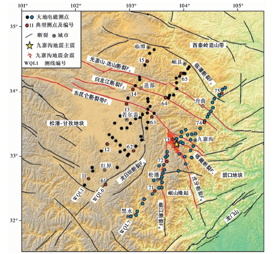
图 1 东昆仑断裂东端研究区的地形、 构造和大地电磁测点分布图断裂修改自Ren等(2013), 余震资料由Fang 等(2018)提供
Fig. 1 The topography and tectonics of the study area, and magnetotelluric stations.
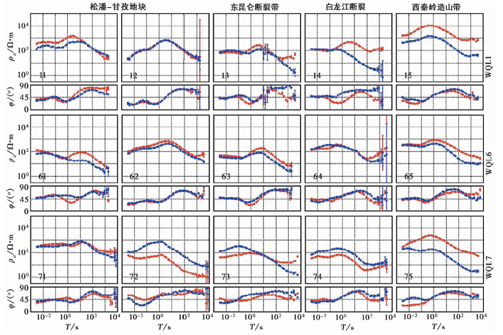
图 2 研究区WQL1、 WQL6和WQL7剖面上典型测点测量方向视电阻率和阻抗相位曲线图红色为NS向, 蓝色为EW向
Fig. 2 Typical apparent resistivity and phase curves of four tectonic units(the Songpan-Ganzi block,the East Kunlun Fault, the Bailongjiang Fault, and the West Qinling orogenic zone)from three profiles.
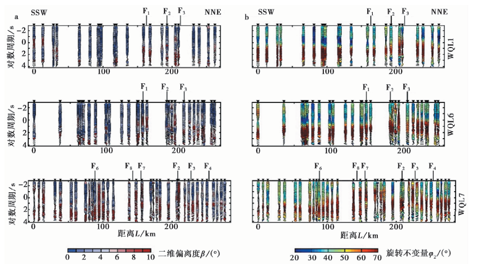
图 3 研究区WQL1、 WQL6和WQL7剖面相位张量二维偏离度(a)和旋转不变量(b)
Fig. 3 The skewness(a) and invariant(b) of the three profiles using phase tensor decomposition technique.
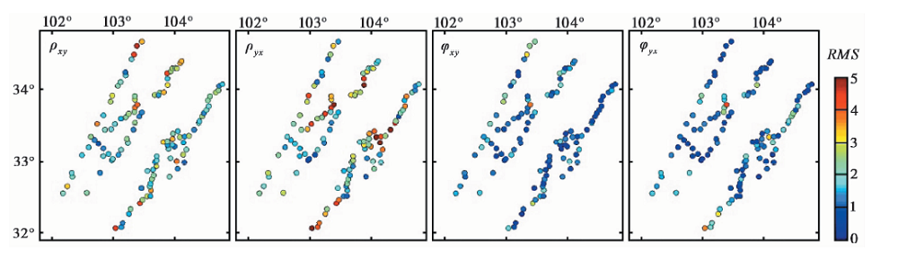
图 4 研究区WQL1、 WQL6剖面和WQL7剖面三维反演各测点4个分量的均方根误差
Fig. 4 The four components RMS misfit at each site on the WQL1, WQL6 and WQL7 profiles.
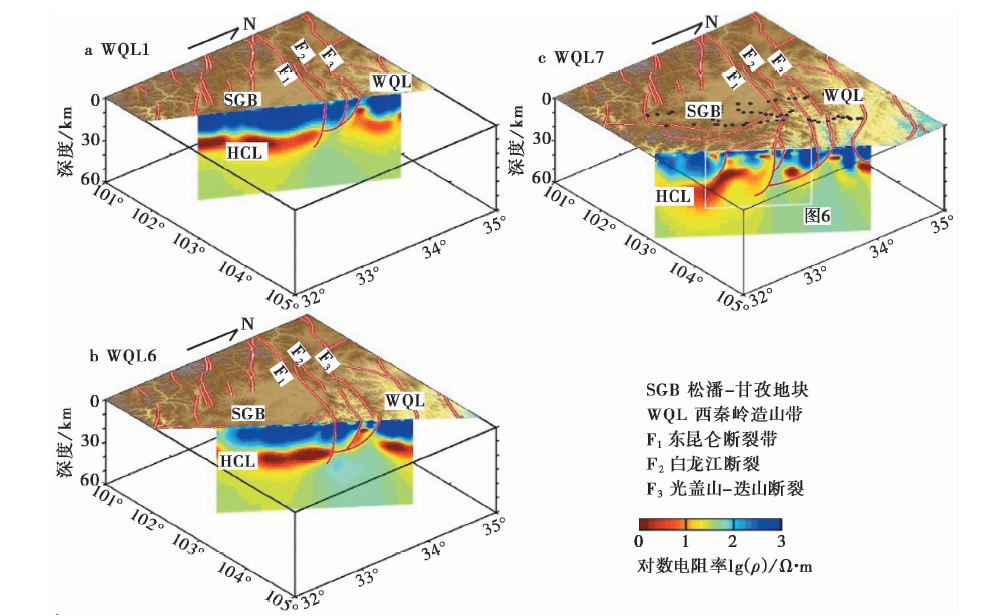
图 5 研究区WQL1、 WQL6和WQL7剖面深部电性结构图像和地质构造解译图
Fig. 5 Deep electrical structure and interpretation of three profiles that cross the eastern terminal of the East Kunlun Fault.
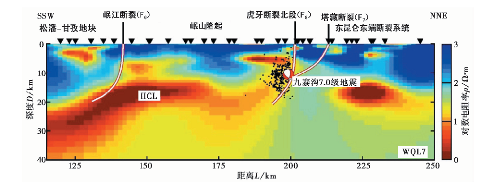
图 6 九寨沟地震区深部电性结构和地震构造解译黑色圆点为九寨沟地震余震(Fang et al., 2018); 震源机制球为剖面投影,修改自GCMT(Ekström et al., 2012); 黑色三角形为MT测点
Fig. 6 Deep electrical structure and interpretation of Jiuzhaigou earthquake region.
| [1] | 嘉世旭, 张先康, 赵金仁, 等. 2009. 若尔盖盆地及周缘褶皱造山带地壳结构——深地震测深结果[J]. 中国科学(D 辑), 39(9): 1200—1208. |
| JIA Shi-xu, ZHANG Xian-kang, ZHAO Jin-ren, et al.2009. Deep seismic sounding data reveal the crustal structures beneath Zoige Basin and its surrounding folded orogenic belts[J]. Science in China(Ser D), 39(9): 1200—1208(in Chinese). | |
| [2] | 鲁人齐, 徐锡伟, 陈立春, 等. 2018. 2017年8月8日九寨沟MS7.0地震构造与震区三维断层初始模型[J]. 地震地质, 40(1): 1—11. doi: 10.3969/j.issn.0253-4967.2018.01.001. |
| LU Ren-qi, XU Xi-wei, CHEN Li-chun, et al.2018. Seismotectonics of the 8 August 2017 Jiuzhaigou earthquake and the three-dimensional fault models in the seismic region[J]. Seismology and Geology, 40(1): 1—11(in Chinese). | |
| [3] | 闵刚, 王绪本, 夏时斌, 等. 2017. 岷山隆起带与西秦岭构造带中段中上地壳电性结构特征[J]. 地球物理学报, 60(6): 2397—2413. |
| MIN Gang, WANG Xu-ben, XIA Shi-bin, et al.2017. Electrical structure of middle and upper crust beneath the Minshan uplift zone and central section of the West Qinling orogenic zone[J]. Chinese Journal of Geophysics, 60(6): 2397—2413(in Chinese). | |
| [4] | 王绪本, 余年, 高嵩, 等. 2017. 青藏高原东缘地壳上地幔电性结构研究进展[J]. 地球物理学报, 60(6): 2350—2370. |
| WANG Xu-ben, YU Nian, GAO Song, et al.2017. Research progress in research on electrical structure of crust and upper mantle beneath the eastern margin of the Tibetan plateau[J]. Chinese Journal of Geophysics, 60(6): 2350—2370(in Chinese). | |
| [5] | 闻学泽, 杜方, 张培震, 等. 2011. 巴彦喀拉块体北和东边界地震序列的关联性与2008年汶川地震[J]. 地球物理学报, 54(3): 706—716. |
| WEN Xue-ze, DU Fang, ZHANG Pei-zhen, et al.2011. Correlation of major earthquake sequences on the northern and eastern boundaries of the Bayan Har block, and its relation to the 2008 Wenchuan earthquake[J]. Chinese Journal of Geophysics, 54(3): 706—716(in Chinese). | |
| [6] | 徐锡伟, 陈桂华, 王启欣, 等. 2017. 九寨沟地震发震断层属性及青藏高原东南缘现今应变状态讨论[J]. 地球物理学报, 60(10): 4018—4026. |
| XU Xi-wei, CHEN Gui-hua, WANG Qi-xin, et al.2017. Discussion on seismogenic structure of Jiuzhaigou earthquake and its implication for current strain state in the southeastern Qinghai-Tibet Plateau[J]. Chinese Journal of Geophysics, 60(10): 4018—4026(in Chinese). | |
| [7] | 徐锡伟, 陈桂华, 于贵华, 等. 2013. 芦山地震发震构造及其与汶川地震关系讨论[J]. 地学前缘, 101(3): 11—20. |
| XU Xi-wei, CHEN Gui-hua, YU Gui-hua, et al.2013. Seismogenic structure of Lushan earthquake and its relationship with Wenchuan earthquake[J]. Earth Science Frontiers, 101(3): 11—20(in Chinese). | |
| [8] | 易桂喜, 龙锋, 梁明剑, 等. 2017. 2017年8月8日九寨沟M7.0地震及余震震源机制解与发震构造分析[J]. 地球物理学报, 60(10): 4083—4097. |
| YI Gui-xi, LONG Feng, LIANG Ming-jian, et al.2017. Focal mechanism solutions and seismogenic structure of the 8 August 2017 M7.0 Jiuzhaigou earthquake and its aftershocks, northern Sichuan[J]. Chinese Journal of Geophysics, 60(10): 4083—4097(in Chinese). | |
| [9] | 詹艳, 杨皓, 赵国泽, 等. 2017. 青藏高原东北缘海原构造带马东山阶区深部电性结构特征及其构造意义[J]. 地球物理学报, 60(6): 2371—2384. |
| ZHAN Yan, YANG Hao, ZHAO Guo-ze, et al.2017. Deep electrical structure of crust beneath the Madongshan step area at the Haiyuan Fault in the northeastern margin of the Tibetan plateau and tectonic implications[J]. Chinese Journal of Geophysics,60(6): 2371—2384(in Chinese). | |
| [10] | 詹艳, 赵国泽, 王立凤, 等. 2014. 西秦岭与南北地震构造带交会区深部电性结构特征[J]. 地球物理学报, 57(8): 2594—2607. |
| ZHAN Yan, ZHAO Guo-ze, WANG Li-feng, et al.2014. Deep electric structure beneath the intersection area of West Qinling orogenic zone with north-south seismic tectonic zone in China[J]. Chinese Journal of Geophysics, 57(8): 2594—2607(in Chinese). | |
| [11] | 张先康, 嘉世旭, 赵金仁, 等. 2008. 西秦岭—东昆仑及邻近地区地壳结构: 深地震宽角反射/折射剖面结果[J]. 地球物理学报, 51(2): 439—450. |
| ZHANG Xian-kang, JIA Shi-xu, ZHAO Jin-ren, et al.2008. Crustal structures beneath West Qinling-East Kunlun orogen and its adjacent area: Results of wide-angle seismic reflection and refraction experiment[J]. Chinese Journal of Geophysics, 51(2): 439—450(in Chinese). | |
| [12] | 张岳桥, 马寅生, 孟晖. 2005. 西秦岭地区东昆仑-秦岭断裂系晚新生代左旋走滑历史及其向东扩展[J]. 地球学报, 26(1): 1—8. |
| ZHANG Yue-qiao, MA Yin-sheng, MENG Hui.2005. Late Cenozoic left-slip faulting process of the East Kunlun-Qinling fault system in West Qinling region and its eastward propagation[J]. Acta Geoscience Sinica, 26(1): 1—8(in Chinese). | |
| [13] | 赵凌强, 詹艳, 陈小斌, 等. 2015a. 西秦岭造山带(中段)及其两侧地块深部电性结构特征[J]. 地球物理学报, 58(7): 2460—2472. |
| ZHAO Ling-qiang, ZHAN Yan, CHEN Xiao-bin, et al.2015a. Deep electrical structure of the central West Qinling orogenic belt and blocks on its either side[J]. Chinese Journal of Geophysics, 58(7): 2460—2472(in Chinese). | |
| [14] | 赵凌强, 詹艳, 孙翔宇, 等. 2019. 利用大地电磁技术揭示2016年1月21日青海门源MS6.4地震隐伏地震构造和孕震环境[J]. 地球物理学报, 62(6): 2088—2100. |
| ZHAO Ling-qiang, ZHAN Yan, SUN Xiang-yu, et al.2019. The hidden seismogenic mechanism and environment of the 21 January Menyuan, Qinghai, MS6.4 earthquake inferred from magnetotelluric imaging[J]. Chinese Journal of Geophysics, 62(6): 2088—2100(in Chinese). | |
| [15] | 赵凌强, 詹艳, 王庆良, 等. 2018. 1954年甘肃民勤7级地震区深部电性结构特征及地震构造环境研究[J]. 地震地质, 40(3): 552—565. doi: 10.3969/j.issn.0253-4967.2018.03.004. |
| ZHAO Ling-qiang, ZHAN Yan, WANG Qing-liang, et al.2018. Deep electrical structure beneath the 1954 MS7.0 Minqin, Gansu earthquake and its seismotectonic environment[J]. Seismology and Geology, 40(3): 552—565(in Chinese). | |
| [16] | 赵凌强, 詹艳, 赵国泽, 等. 2015b. 基于深部电性结构特征的2013年甘肃岷县-漳县MS6.6地震孕震环境探讨[J]. 地震地质, 37(2): 541—554. doi: 10.3969/j.issn.0253-4967.2015.02.016. |
| ZHAO Ling-qiang, ZHAN Yan, ZHAO Guo-ze, et al.2015. The seismogenic environment of the 2013 Minxian-Zhangxian MS6.6 earthquake based on the deep electrical structure[J]. Seismology and Geology, 37(2): 541—554(in Chinese). | |
| [17] | 郑文俊, 袁道阳, 何文贵, 等. 2013. 甘肃东南地区构造活动与2013年岷县-漳县MS6.6地震孕震机制[J]. 地球物理学报, 56(12): 4058—4071. |
| ZHENG Wen-jun, YUAN Dao-yang, HE Wen-gui, et al.2013. Geometric pattern and active tectonics in southeastern Gansu Province: Discussion on seismogenic mechanism of the Minxian-Zhangxian MS6.6 earthquake on July 22, 2013[J]. Chinese Journal of Geophysics, 56(12): 4058—4071(in Chinese). | |
| [18] | 周永胜, 何昌荣, 2009. 汶川地震区的流变结构与发震高角度逆断层滑动的力学条件[J]. 地球物理学报, 52(2): 474—484. |
| ZHOU Yong-sheng, HE Chang-rong.2009. The rheological structures of crust and mechanics of high-angle reverse fault slip for Wenchuan MS8.0 earthquake[J]. Chinese Journal of Geophysics, 52(2): 474—484(in Chinese). | |
| [19] | Aizawa K, Asaue H, Koike K, et al.2017. Seismicity controlled by resistivity structure: The 2016 Kumamoto earthquakes, Kyushu Island, Japan[J]. Earth, Planets and Space, 69:4. |
| [20] | Arora B R R, Bansal B K K, Prajapati S K, et al.2017. Seismotectonics and seismogenesis of MW7.8 Gorkha earthquake and its aftershocks[J]. Journal of Asian Earth Sciences, 133:2—11. |
| [21] | Bai D, Unsworth M J, Meju M A, et al.2010. Crustal deformation of the eastern Tibetan plateau revealed by magnetotelluric imaging[J]. Nature Geoscience, 3(5): 358—362. |
| [22] | Becken M, Ritter O, Bedrosian P A, et al.2011. Correlation between deep fluids, tremor and creep along the central San Andreas Fault[J]. Nature, 480(7275): 87—90. |
| [23] | Bibby H M, Caldwell T G, Brown C.2005. Determinable and non-determinable parameters of galvanic distortion in magnetotellurics[J]. Geophysical Journal International, 163(3): 915—930. |
| [24] | Booker J R.2014. The magnetotelluric phase tensor: A critical review[J]. Surveys in Geophysics, 35(1): 7—40. |
| [25] | Bürgmann R.2018. The geophysics, geology and mechanics of slow fault slip[J]. Earth and Planetary Science Letters, 495:112—134. |
| [26] | Cai J, Chen X, Xu X, et al.2017. Rupture mechanism and seismotectonics of the MS6.5 Ludian earthquake inferred from three-dimensional magnetotelluric imaging[J]. Geophysical Research Letters, 44(3): 1275—1285. |
| [27] | Caldwell T G, Bibby H M, Brown C.2004. The magnetotelluric phase tensor[J]. Geophysical Journal International, 158(2): 457—469. |
| [28] | Egbert G D, Booker J R.1986. Robust estimation of geomagnetic transfer functions[J]. Geophysical Journal of the Royal Astronomical Society, 87(1): 173—194. |
| [29] | Egbert G D, Kelbert A.2012. Computational recipes for electromagnetic inverse problems[J]. Geophysical Journal International, 189(1): 251—267. |
| [30] | Ekström G, Nettles M, Dziewonski A M.2012. The global CMT project 2004—2010: Centroid-moment tensors for 13 017 earthquakes[J]. Physics of the Earth and Planetary Interiors, 200-201:1—9. |
| [31] | Fang L, Wu J, Su J, et al.2018. Relocation of mainshock and aftershock sequence of the MS7.0 Sichuan Jiuzhaigou earthquake[J]. Chinese Science Bulletin, 63(7): 649—662. |
| [32] | Gamble T D, Goubau W M, Clarke J.1979. Error analysis for remote reference magnetotellurics[J]. Geophysics, 44(5): 959—968. |
| [33] | Gao R, Wang H, Zeng L, et al.2014. The crust structures and the connection of the Songpan block and West Qinling orogen revealed by the Hezuo-Tangke deep seismic reflection profiling[J]. Tectonophysics, 634:227—236. |
| [34] | Han L, Zhou Y, He C, et al.2016. Sublithostatic pore fluid pressure in the brittle-ductile transition zone of Mesozoic Yingxiu-Beichuan Fault and its implication for the 2008 MW7.9 Wenchuan earthquake[J]. Journal of Asian Earth Sciences, 117:107—118. |
| [35] | Hao M, Wang Q, Shen Z, et al.2014. Present-day crustal vertical movement inferred from precise leveling data in eastern margin of Tibetan plateau[J]. Tectonophysics, 632:281—292. |
| [36] | Heise W, Caldwell T G, Bibby H M, et al.2008. Three-dimensional modelling of magnetotelluric data from the Rotokawa geothermal field, Taupo Volcanic Zone, New Zealand[J]. Geophysical Journal International, 173(2): 740—750. |
| [37] | Kelbert A, Meqbel N, Egbert G D, et al.2014. ModEM: A modular system for inversion of electromagnetic geophysical data[J]. Computers and Geosciences, 66:40—53. |
| [38] | Kirby E, Whipple K X, Burchfiel B C, et al.2000. Neotectonics of the Min Shan, China: Implications for mechanisms driving Quaternary deformation along the eastern margin of the Tibetan plateau[J]. Geological Society of America Bulletin, 112(3): 375—393. |
| [39] | Kirby E, Harkins N, Wang E, et al.2007. Slip rate gradients along the eastern Kunlun Fault[J]. Tectonics, 26(2): TC2010. |
| [40] | Li C X, Xu X W, Wen X Z, et al.2011. Rupture segmentation and slip partitioning of the mid-eastern part of the Kunlun Fault, north Tibetan plateau[J]. Science China Earth Sciences, 54(11): 1730—1745. |
| [41] | Liu Z, Tian X, Gao R, et al.2017. New images of the crustal structure beneath eastern Tibet from a high-density seismic array[J]. Earth and Planetary Science Letters, 480:33—41. |
| [42] | Mohan K, Rastogi B K, Chaudhary P.2015. Magnetotelluric studies in the epicenter zone of 2001, Bhuj earthquake[J]. Journal of Asian Earth Sciences, 98:75—84. |
| [43] | Ren J, Xu X, Yeats R S, et al.2013. Millennial slip rates of the Tazang Fault, the eastern termination of Kunlun Fault: Implications for strain partitioning in eastern Tibet[J]. Tectonophysics, 68:1180—1200. |
| [44] | Sun J, Yue H, Shen Z, et al.2018. The 2017 Jiuzhaigou earthquake: A complicated event occurred in a young fault system[J]. Geophysical Research Letters, 45(5): 2230—2240. |
| [45] | Tapponnier P, Xu Z Q, Roger F, et al.2001. Oblique stepwise rise and growth of the Tibet Plateau[J]. Science, 294(5547): 1671—1677. |
| [46] | Unsworth M, Bedrosian P A.2004. Electrical resistivity structure at the SAFOD site from magnetotelluric exploration[J]. Geophysical Research Letters, 31(12): L12S05. |
| [47] | Wang C, Gao R, Yin A, et al.2011. A mid-crustal strain-transfer model for continental deformation: A new perspective from high-resolution deep seismic-reflection profiling across NE Tibet[J]. Earth and Planetary Science Letters, 306(3-4): 279—288. |
| [48] | Wang X, Zhang G, Fang H, et al.2014. Crust and upper mantle resistivity structure at middle section of Longmenshan, eastern Tibetan plateau[J]. Tectonophysics, 619-620:143—148. |
| [49] | Wessel P, Smith W H F, Scharroo R.2013. Generic mapping tools: Improved version released[J]. Eos Transactions American Geophysical Union, 94(45): 409—410. |
| [50] | Xiao Q, Yu G, Liu-Zeng J, et al.2017. Structure and geometry of the Aksay restraining double bend along the Altyn Tagh Fault, northern Tibet, imaged using magnetotelluric method[J]. Geophysical Research Letters, 44(9): 4090—4097. |
| [51] | Ye Z, Gao R, Li Q, et al.2015. Seismic evidence for the North China plate underthrusting beneath northeastern Tibet and its implications for plateau growth[J]. Earth and Planetary Science Letters, 426:109—117. |
| [52] | Zhan Y, Zhao G, Unsworth M, et al.2013. Deep structure beneath the southwestern section of the Longmenshan fault zone and seismogenetic context of the 4·20 Lushan MS7.0 earthquake[J]. Chinese Science Bulletin, 58(28-29): 3467—3474. |
| [53] | Zhang P Z, Wen X, Shen Z K, et al.2010. Oblique, high-angle, listric-reverse faulting and associated development of strain: The Wenchuan earthquake of May 12, 2008, Sichuan, China[J].Annual Review of Earth and Planetary Sciences, 38(1): 353—382. |
| [54] | Zhang Y, Dong S, Yang N.2009. Active faulting pattern, present-day tectonic stress field and block kinematics in the east Tibetan plateau[J]. Acta Geologica Sinica(English Edition), 83(4): 694—712. |
| [55] | Zhang Y, Zhang G, Hetland E A, et al.2018. Source fault and slip distribution of the 2017 MW6.5 Jiuzhaigou, China, earthquake and its tectonic implications[J]. Seismological Research Letters, 89(4): 1345—1353. |
| [56] | Zhao G, Unsworth M J, Zhan Y, et al.2012. Crustal structure and rheology of the Longmenshan and Wenchuan MW7.9 earthquake epicentral area from magnetotelluric data[J]. Geology, 40(12): 1139—1142. |
| [1] | 杨建文, 金明培, 叶泵, 茶文剑, 黑贺堂. 基于背景噪声成像方法研究滇西北中上地壳三维速度结构及孕震环境[J]. 地震地质, 2025, 47(4): 1113-1131. |
| [2] | 刘文玉, 程正璞, 年秀清, 陈闫, 胡钰铃, 覃祖建, 邵明正. 基于三维剩余密度结构的松原地震成因[J]. 地震地质, 2024, 46(2): 462-476. |
| [3] | 方东, 胡敏章, 郝洪涛. 青藏高原东南缘重力场多尺度分析及其构造含义[J]. 地震地质, 2021, 43(5): 1208-1232. |
| [4] | 孙翔宇, 詹艳, 赵国泽, 赵凌强, 邓琰, 胡亚轩, 胡久常, 向小娟. 琼东北马鞍岭-雷虎岭火山区深部岩浆系统大地电磁三维探测[J]. 地震地质, 2020, 42(3): 640-653. |
| [5] | 蒋靖祥, 尹光华, 温和平, 余建和. 库车坳陷的地震孕震环境初探[J]. 地震地质, 2002, 24(3): 346-354. |
| 阅读次数 | ||||||
|
全文 |
|
|||||
|
摘要 |
|
|||||
