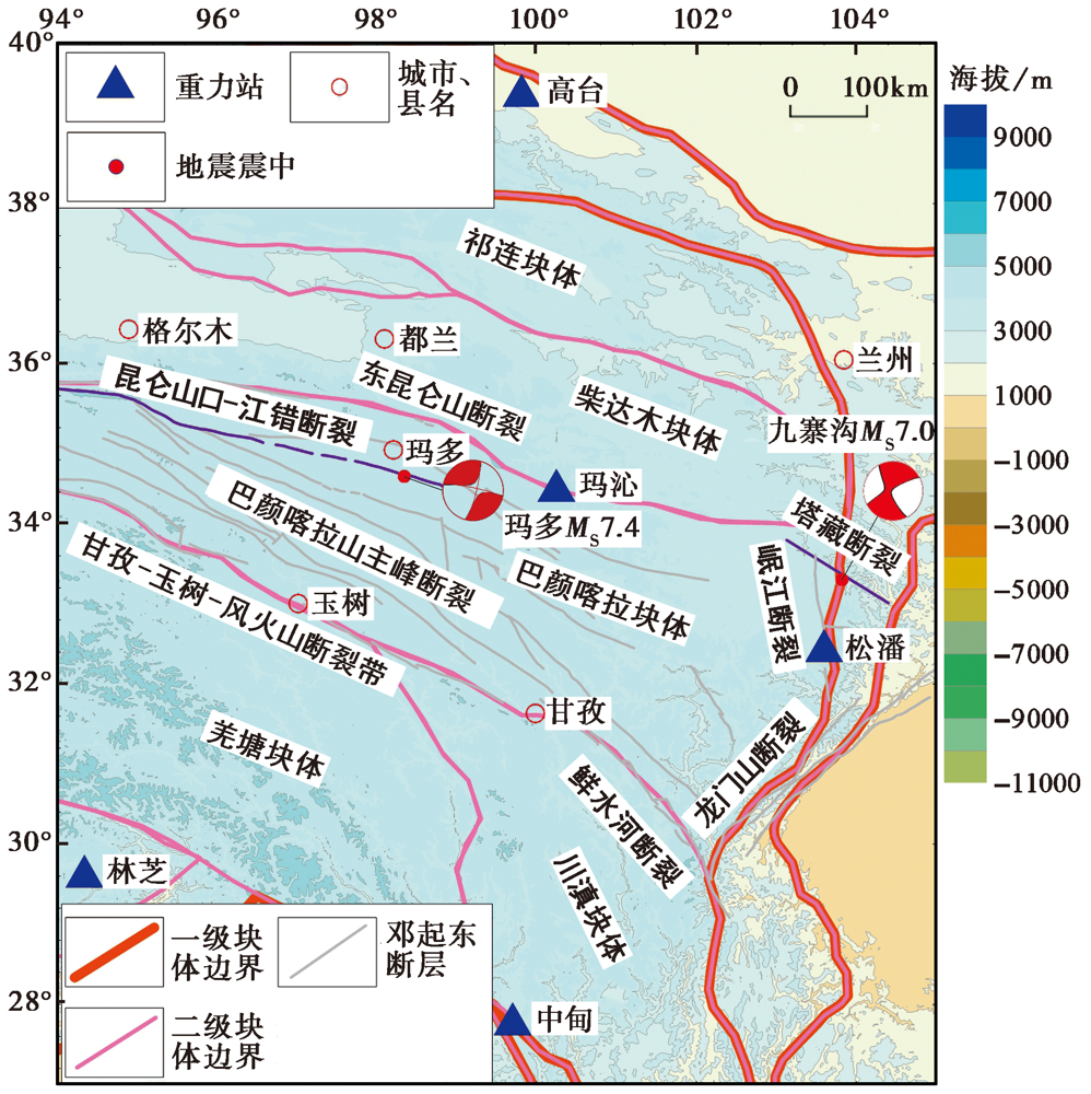
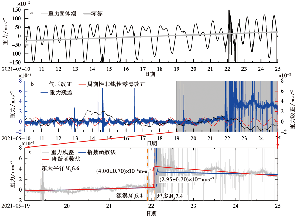
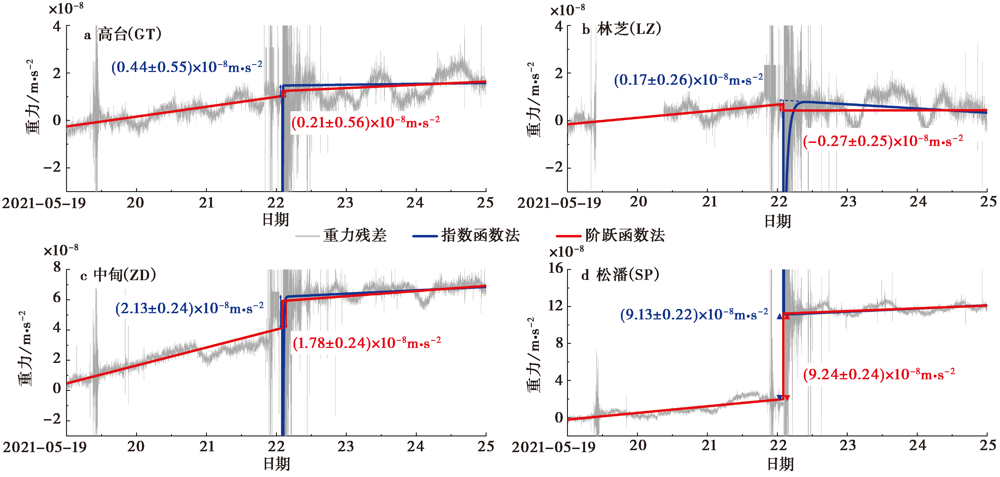
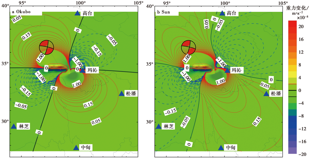
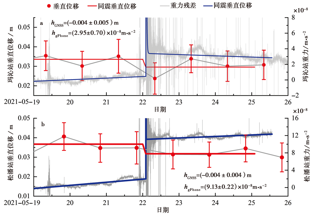
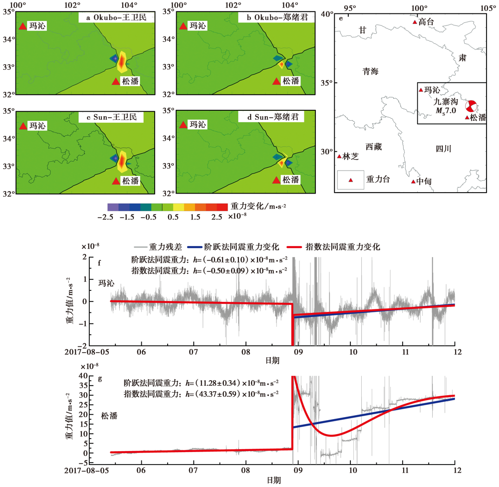
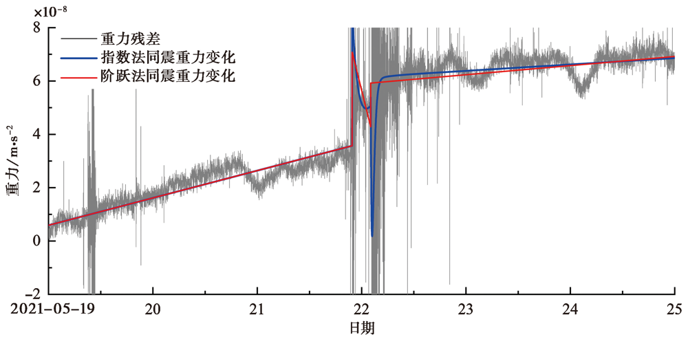
| [1] |
邓明莉, 孙和平, 徐建桥, 等. 2014. 芦山地震同震和震后地表形变及重力变化的理论模拟[J]. 地球科学(中国地质大学学报), 39(9): 1373-1382.
|
|
DENG Ming-li, SUN He-ping, XU Jian-qiao, et al. 2014. Theoretical simulation of co-seismic and post-seismic deformations and gravity changes of Lushan earthquake[J]. Earth Science(Journal of China University of Geosciences), 39(9): 1373-1382. (in Chinese)
|
| [2] |
付广裕. 2012. 球体位错理论在2011年日本强震中的应用研究[J]. 大地测量与地球动力学, 32(6): 1-7.
|
|
FU Guang-yu. 2012. Application of spherical dislocation theory to 2011 Tohoku-Oki earthquake, Japan[J]. Journal of Geodesy and Geodynamics, 32(6): 1-7. (in Chinese)
|
| [3] |
华俊, 赵德政, 单新建, 等. 2021. 2021年青海玛多MW7.3地震InSAR的同震形变场、 断层滑动分布及其对区域的应力扰动[J]. 地震地质, 43(3): 677-691.
|
|
HUA Jun, ZHAO De-zheng, SHAN Xin-jian, et al. 2021. Coseismic deformation field, slip distribution and Coulomb stress disturbance of the 2021 MW7.3 Maduo earthquake using Sentinel -1 InSAR observations[J]. Seismology and Geology, 43(3): 677-691. (in Chinese)
|
| [4] |
韦进, 郝洪涛, 杨锦玲, 等. 2020. 利用福州gPhone重力仪检测杜鹃台风激发的第二类脉动信号[J]. 地球物理学进展, 35(6): 2107-2115.
|
|
WEI Jin, HAO Hong-tao, YANG Jin-ling, et al. 2020. Detecting DF microseisms by gPhone gravimeter on Fuzhou seismic station during Dujuan typhoon[J]. Progress in Geophysics, 35(6): 2107-2115. (in Chinese)
|
| [5] |
韦进, 郝洪涛, 张晓彤, 等. 2021. 利用中国北部连续重力站资料评估全球潮汐模型精度[J]. 地震学报, 43(1): 84-99.
|
|
WEI Jin, HAO Hong-tao, ZHANG Xiao-tong, et al. 2021. Accuracy estimation of global tide models using continuous gravity observation data in northern China[J]. Acta Seismologica Sinica, 43(1): 84-99. (in Chinese)
|
| [6] |
郗钦文, 侯天航. 1986. 固体潮汐与引潮常数[J]. 中国地震, 2(2): 30-41.
|
|
XI Qin-wen, HOU Tian-hang. 1986. Earth tides and generating tide constants[J]. Earthquake Research in China, 2(2): 30-41. (in Chinese)
|
| [7] |
杨锦玲, 李祖宁, 关玉梅, 等. 2017. 于田MS7.3地震前重力扰动信号研究[J]. 地球物理学报, 60(10): 3844-3852.
|
|
YANG Jin-ling, LI Zu-ning, GUAN Yu-mei, et al. 2017. Study on gravity disturbance before the Yutian MS7.3 earthquake[J]. Chinese Journal of Geophysics, 60(10): 3844-3852. (in Chinese)
|
| [8] |
张喆, 许力生. 2021. 2021年青海果洛MW7.5地震矩心矩张量解[J]. 地震学报, 43(3): 1-5.
|
|
ZHANG Zhe, XU Li-sheng. 2021. The centroid moment tensor solution of the 2021 MW7.5 Guoluo, Qinghai, earthquake[J]. Acta Seismologica Sinica, 43(3): 1-5. (in Chinese)
|
| [9] |
郑绪君, 张勇, 汪荣江. 2017. 采用IDS方法反演强震数据确定2017年8月8日九寨沟地震的破裂过程[J]. 地球物理学报, 60(11): 4421-4430.
|
|
ZHENG Xu-jun, ZHANG Yong, WANG Rong-jiang. 2017. Estimating the rupture process of the 8 August 2017 Jiuzhaigou earthquake by inverting strong-motion data with IDS method[J]. Chinese Journal of Geophysics, 60(11): 4421-4430. (in Chinese)
|
| [10] |
祝意青, 梁伟锋, 赵云峰, 等. 2017. 2017年四川九寨沟MS7.0地震前区域重力场变化[J]. 地球物理学报, 60(10): 4124-4131.
|
|
ZHU Yi-qing, LIANG Wei-feng, ZHAO Yun-feng, et al. 2017. Gravity changes before the Jiuzhaigou, Shichuan, MS7.0 earthquake of 2017[J]. Chinese Journal of Geophysics, 60(10): 4124-4131. (in Chinese)
|
| [11] |
Barnes D. 1966. Gravity change during the Alaska earthquake[J]. Journal of Geophysical Research, 71(2): 451-457.
DOI
URL
|
| [12] |
Imanishi Y, Sato T, Higashi T, et al. 2004. A network of superconducting gravimeters detects submicrogal coseismic gravity changes[J]. Science, 306(5695): 476-478.
PMID
|
| [13] |
Imanishi Y, Tamura Y, Ikeda H, et al. 2009. Permanent gravity changes recorded on superconducting gravimeters from earthquakes in central Japan: The Noto Hantou and Niigataken Chuetsu-oki events in 2007[J]. Journal of Geodynamics, 48(3-5): 260-268.
DOI
URL
|
| [14] |
Niebauer T M, MacQueen J, Aliod D, et al. 2011. Monitoring earthquakes with gravity meters[J]. Geodesy and Geodynamics, 2(3): 71-75.
|
| [15] |
Okada Y. 1985. Surface deformation due to shear and tensile faults in a half-space[J]. Bulletin of the Seismological Society of America, 75(4): 1135-1154.
DOI
URL
|
| [16] |
Okada Y. 1992. Internal deformation due to shear and tensile faults in a half-space[J]. Bulletin of the Seismological Society of America, 82(2): 1018-1040.
DOI
URL
|
| [17] |
Okubo S. 1992. Gravity and potential changes due to shear and tensile faults in a half-Space[J]. Journal of Geophysical Research, 97(B5): 7137-7144.
DOI
URL
|
| [18] |
Prasad K N D, Srinivas N, Meshram A E, et al. 2017. Co-seismic gravity changes in the Koyna-Warna region: Implications of mass redistribution[J]. Journal of the Geological Society of India, 90(6): 704-710.
DOI
URL
|
| [19] |
Sun W K, Okubo S, Fu G Y. 2006. Green’s function of coseismic strain changes and investigation of effects of Earth’s spherical curvature and radial heterogeneity[J]. Geophysical Journal International, 167(3): 1273-1291.
DOI
URL
|
| [20] |
Sun W K, Okubo S, Fu G Y, et al. 2009. General formulations of global co-seismic deformations caused by an arbitrary dislocation in a spherically symmetric earth model-applicable to deformed earth surface and space-fixed point[J]. Geophysical Journal International, 177(3): 817-833.
DOI
URL
|
| [21] |
Tanaks Y, Okubo S, Machida M, et al. 2001. First detection of absolute gravity change caused by earthquake[J]. Geophysical Research Letters, 28(15): 2979-2981.
DOI
URL
|
| [22] |
Van Camp M, de Viron O, Watlet A, et al. 2017. Geophysics from terrestrial time-variable gravity measurements[J]. Reviews of Geophysics, 55(4): 938-992.
DOI
URL
|
| [23] |
Wei J, Zhao B, Tan H B, et al. 2013. Detection of a half-microgal coseismic gravity change after the MS7.0 Lushan earthquake[J]. Geodesy and Geodynamics, 4(3): 7-11.
|
| [24] |
Xing L L, Liu Z W, Jia J G, et al. 2021. Far-field co-seismic gravity changes related to the 2015 MW7.8 Nepal(Gorkha)earthquake observed by superconducting gravimeters in Chinese mainland[J]. Earth and Planetary Physics, 5(2): 141-148.
DOI
URL
|
 ), 郝洪涛1,2,4), 韩宇飞3), 胡敏章1,2,4), 江颖1,2,4), 刘子维1,2,4)