地震地质 ›› 2021, Vol. 43 ›› Issue (5): 1140-1156.DOI: 10.3969/j.issn.0253-4967.2021.05.007
• 云南漾濞6.4级地震与青海玛多7.4级地震研究专题 • 上一篇 下一篇
石磊1,2)( ), 李永华1,2), 张瑞青1,2)
收稿日期:2021-06-15
修回日期:2021-07-14
出版日期:2021-10-20
发布日期:2021-12-06
作者简介:石磊, 女, 1984年生, 2012年于中国地质大学(北京)获地球探测与信息技术专业博士学位, 副研究员, 主要从事位场方法和地球动力学方面的研究, E-mail: shilei@cea-igp.ac.cn。
基金资助:
SHI Lei1,2)(), LI Yong-hua1,2), ZHANG Rui-qing1,2)
Received:2021-06-15
Revised:2021-07-14
Online:2021-10-20
Published:2021-12-06
摘要:
2021年5月21日云南漾濞发生了6.4级地震, 造成35人伤亡, 受灾面积近6 500km2。文中基于WGM2012布格重力异常、 ETOPO1高程和接收函数估计得到的莫霍面深度资料, 考虑密度差的横向变化, 计算得到了该地震震源区及周边地区的重力均衡异常。研究结果表明: 地壳平均密度与上地幔顶部密度差的变化范围为0.3~0.55g/cm3, 漾濞地震震源区位于密度差过渡带。研究区6.5级及以上地震分布在重力均衡异常(艾里均衡理论莫霍面深度与接收函数H-κ叠加扫描法得到莫霍面的深度之差)梯度带的频率高于极值区。漾濞地震震源区处于均衡异常为4km的梯度带上, 且梯度带与维西-乔后-巍山断裂带的走向基本一致。重力均衡异常梯度带为异常变化较快的地区, 我们推测这些地区可能处于不稳定状态, 有利于应变能的积累, 为使地壳达到均衡, 多从这些地方开始调整, 从而导致地震的发生。
中图分类号:
石磊, 李永华, 张瑞青. 云南漾濞6.4级地震震源区及周边的重力均衡特征[J]. 地震地质, 2021, 43(5): 1140-1156.
SHI Lei, LI Yong-hua, ZHANG Rui-qing. THE GRAVITY ISOSTATIC CHARACTERISTICS OF THE EPICENTER AND ITS SURROUNDING REGIONS OF THE YANGBI MS6.4, YUNNAN EARTHQUAKE[J]. SEISMOLOGY AND EGOLOGY, 2021, 43(5): 1140-1156.
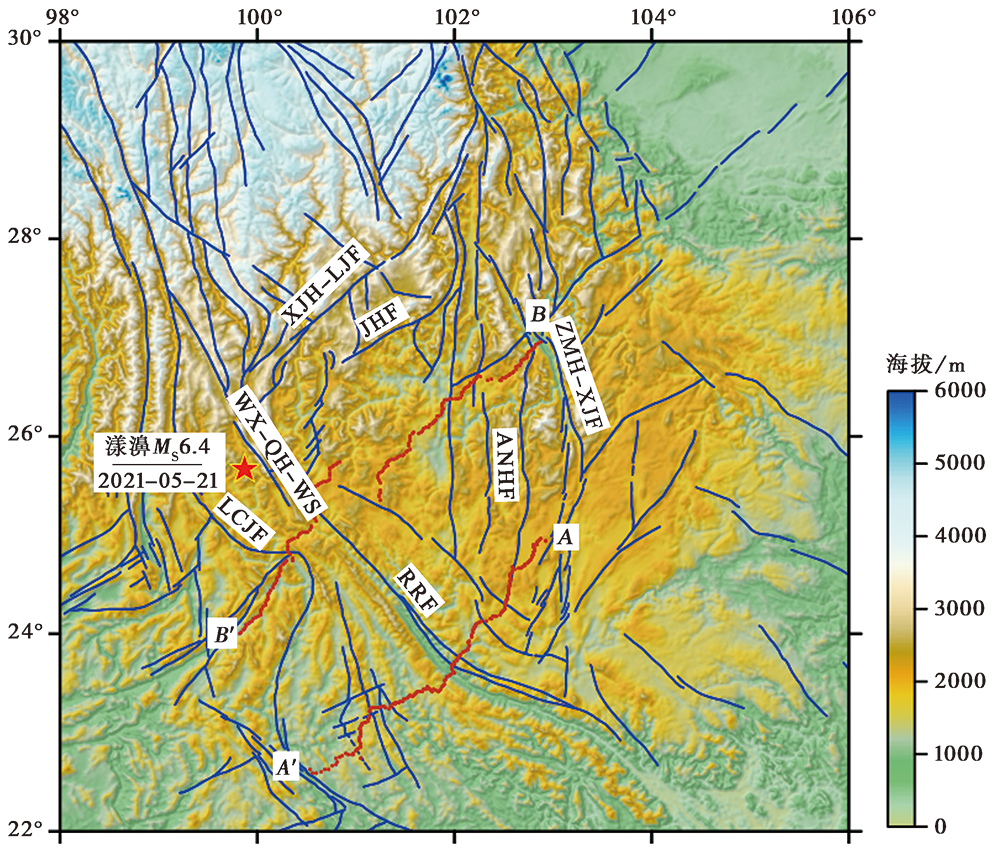
图 1 研究区主要构造与地形 LCJF 澜沧江断裂带; WX-QH-WS 维西-乔后-巍山断裂带; RRF 红河断裂带; XJH-LJF 小金河-丽江断裂带; JHF 菁河断裂带; ANHF 安宁河断裂带; ZMH-XJF 则木河-小江断裂带。红色五角星为本次漾濞 MS6.4 地震的震中位置, 蓝色实线为断裂(Deng et al., 2002), 暗红色圆点为实际测量剖面的位置
Fig. 1 Tectonic features and topography in the study area, colors show the elevations.

图 2 研究区的布格重力异常
Fig. 2 The Bouguer gravity anomaly in the study area.
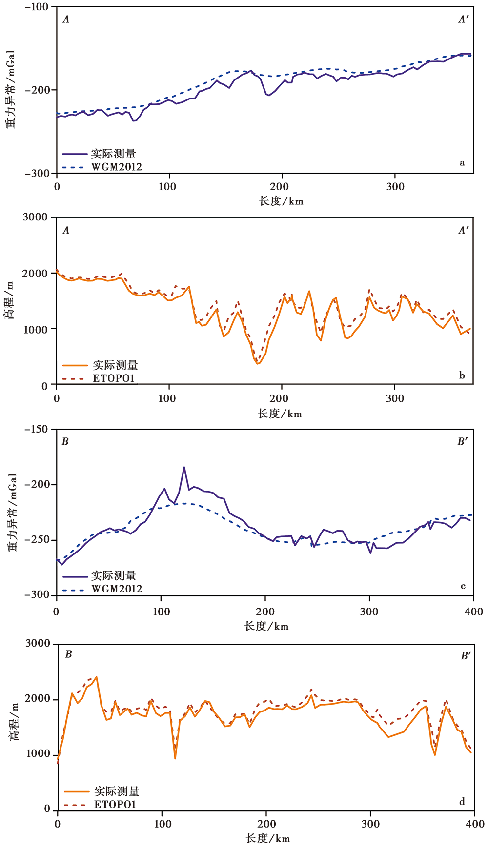
图 3 剖面实际测量结果与WGM2012和ETOPO1模型数据的对比 紫色实线为实际测量重力数据得到的布格异常, 蓝色虚线为WGM2012模型提取的相同点的布格异常,黄色实线为实际测量的测点地形, 红色虚线为ETOPO1模型提取的相同点的高程。剖面位置见图1
Fig. 3 The comparison of measurement gravity anomaly(a, c)and topography(b, d)with the models of WGM2012 and ETOPO1.
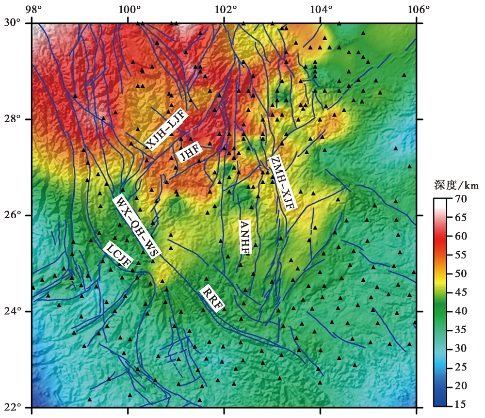
图 4 基于接收函数估计得到的莫霍面深度(Zheng et al., 2019) 黑色三角形为研究区流动台站分布位置
Fig. 4 The Moho depth estimated from receiver functions(Zheng et al., 2019).
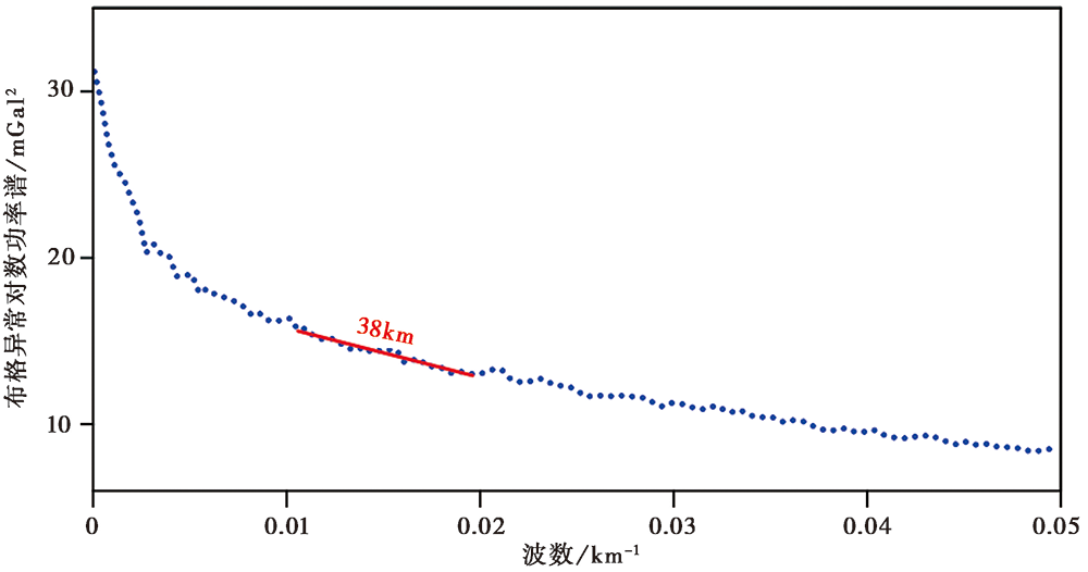
图 5 参考莫霍面深度估计 红色直线为功率谱的拟合回归线
Fig. 5 The estimation of reference Moho.
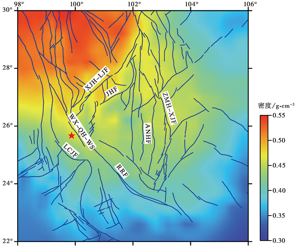
图 6 研究区的壳幔密度差
Fig. 6 The crust-mantle density contrast in the research area.
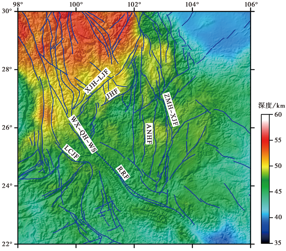
图 7 研究区的艾里均衡理论莫霍面深度
Fig. 7 The Airy Moho in the research area.
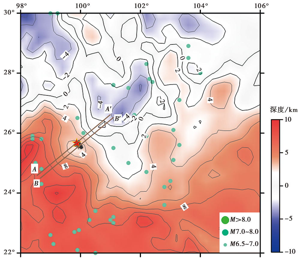
图 8 研究区的重力均衡异常 图中不同大小的圆点代表6.5级及以上震级地震的震中, 红色三角形为漾濞地震震中,黑色圆点为余震震中, 棕色实线为穿过震中和余震的剖面位置
Fig. 8 The gravity isostatic anomaly in the research area.
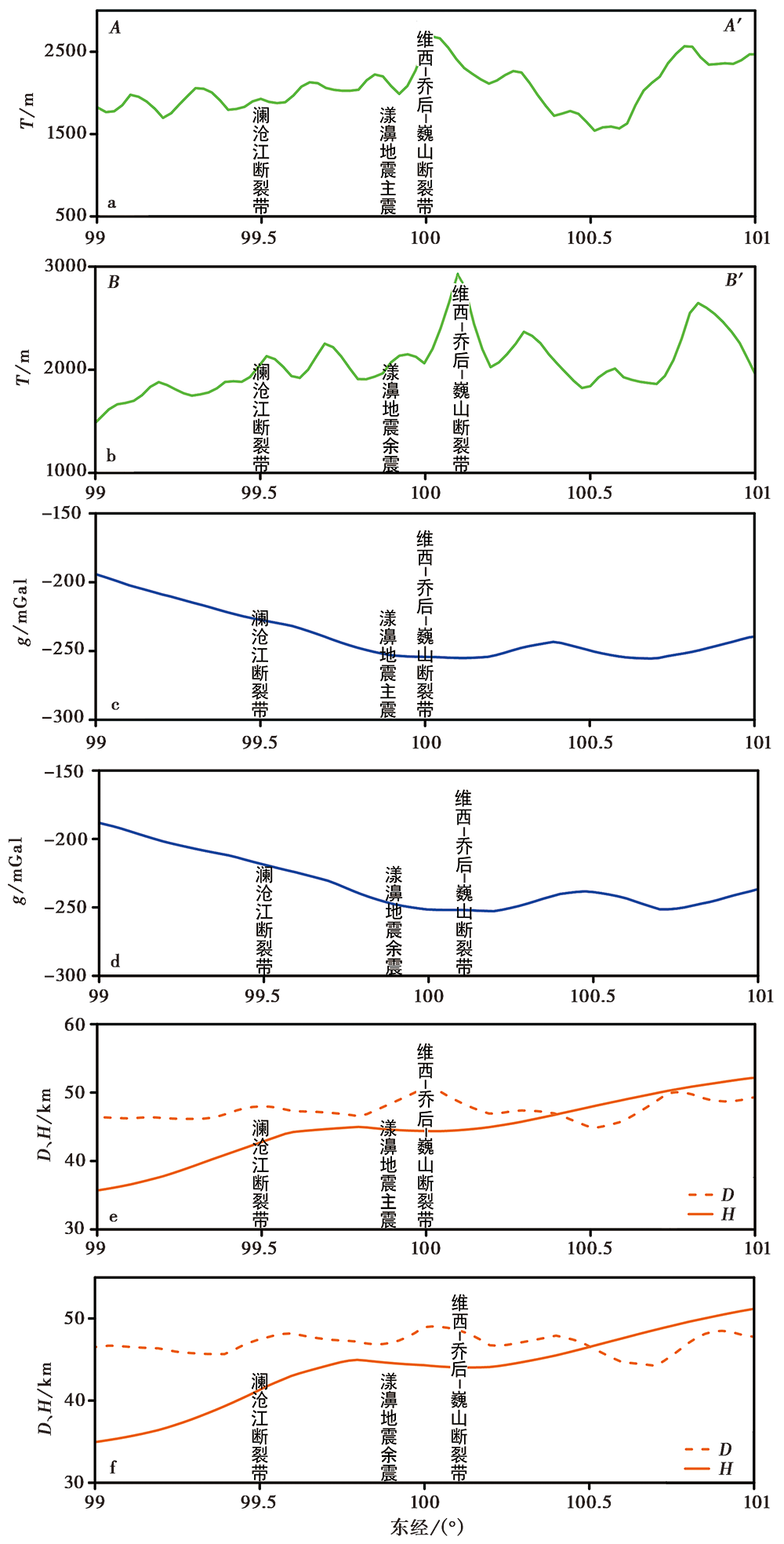
图 9 2条剖面的地形、 布格异常和D、 H差异曲线
Fig. 9 Topography(a, b), Bouguer gravity anomaly(c, d)and the differences between D and H(e, f)for two profiles.
| [1] | 方盛明, 冯锐, 田长征, 等. 1997. 亚洲中部地区均衡重力异常特征及地震活动性[J]. 地震学报, 19(6): 650-654. |
| FANG Sheng-ming, FENG Rui, TIAN Chang-zheng, et al. 1997. The characteristics of isostatic anomalies and earthquake activties in central Asia[J]. Acta Seismological Sinica, 19(6): 650-654. (in Chinese) | |
| [2] | 郭良辉, 孟小红, 石磊, 等. 2012. 优化滤波方法及其在中国大陆布格重力异常数据处理中的应用[J]. 地球物理学报, 55(12): 4078-4088. |
| GUO Liang-hui, MENG Xiao-hong, SHI Lei, et al. 2012. Preferential filtering method and its application to Bouguer gravity anomaly of Chinese continent[J]. Chinese Journal of Geophysics, 55(12): 4078-4088. (in Chinese) | |
| [3] | 黄建平, 傅容珊, 许萍, 等. 2006. 利用重力和地形观测反演中国及邻区地壳厚度[J]. 地震学报, 28(3): 250-258. |
| HUANG Jian-ping, FU Rong-shan, XU Ping, et al. 2006. Inversion of gravity and topography data for the crust thickness of China and its adjacency[J]. Acta Seismologica Sinica, 28(3): 250-258. (in Chinese) | |
| [4] | 姜文亮, 张景发. 2011. 川滇地区重力场与深部结构特征[J]. 地球物理学进展, 26(6): 1915-1924. |
| JIANG Wen-liang, ZHANG Jing-fa. 2011. Deep structures of Sichuan-Yunnan region derived from gravity data[J]. Progress in Geophysics, 26(6): 1915-1924. (in Chinese) | |
| [5] | 雷兴林, 王志伟, 马胜利, 等. 2021. 关于2021年2021年5月滇西漾濞 MS6.4 地震序列特征及成因的初步研究[J]. 地震学报, 43(3): 1-24. |
| LEI Xing-lin, WANG Zhi-wei, MA Sheng-li, et al. 2021. A preliminary study on the MS6.4, May 2021 Yangbi earthquake sequence, Yunnan, China[J]. Acta Seismologica Sinica, 43(3): 1-24. (in Chinese) | |
| [6] | 李永华, 徐小明, 张恩会, 等. 2014. 青藏高原东南缘地壳结构及云南鲁甸、 景谷地震深部孕震环境[J]. 地震地质, 36(4): 1204-1216. |
| LI Yong-hua, XU Xiao-ming, ZHANG En-hui, et al. 2014. Three-dimensional crust structure beneath SE Tibetan plateau and its seismotectionic implications for the Ludian and Jinggu earthquakes[J]. Seismology and Geology, 36(4): 1204-1216. (in Chinese) | |
| [7] | 刘云龙, 王谦身, 武传真. 1977. 喜马拉雅山脉中部地区的地壳构造及其地质意义探讨[J]. 地球物理学报, 20(2): 143-149. |
| LIU Yun-long, WANG Qian-shen, WU Chuan-zhen. 1977. A preliminary study of the crustal structure and the geological significance of the central portion of the Himalayan mountain range[J]. Chinese Journal of Geophysics, 20(2): 143-149. (in Chinese) | |
| [8] | 楼海, 王椿镛. 2005. 川滇地区重力异常的小波分解与解释[J]. 地震学报, 27(5): 515-523. |
| LOU Hai, WANG Chun-yong. 2005. Wavelet analysis and interpretation of gravity data in Sichuan-Yunnan region, China[J]. Acta Seismologica Sinica, 27(5): 515-523. (in Chinese) | |
| [9] | 石磊, 楼海, 王谦身, 等. 2015. 攀西地区重力场特征及地壳密度结构[J]. 地球物理学报, 58(7): 2402-2412. |
| SHI Lei, LOU Hai, WANG Qian-shen, et al. 2015. Gravity field characteristics and crust density structure in the Panxi region, China[J]. Chinese Journal of Geophysics, 58(7): 2402-2412. (in Chinese) | |
| [10] | 王谦身, 滕吉文, 张永谦, 等. 2009. 四川中西部地区地壳结构与重力均衡[J]. 地球物理学报, 52(2): 579-583. |
| WANG Qian-shen, TENG Ji-wen, ZHANG Yong-qian, et al. 2009. The crustal structure and gravity isostasy in the middle western Sichuan area[J]. Chinese Journal of Geophysics, 52(2): 579-583. (in Chinese) | |
| [11] | 王谦身, 滕吉文, 张永谦, 等. 2013. 中秦岭地带重力异常特征及地壳结构的探榷[J]. 地球物理学报, 56(12): 3999-4008. |
| WANG Qian-shen, TENG Ji-wen, ZHANG Yong-qian, et al. 2013. Discussion on gravity anomalies and crustal structure of the middle Qinling Mountains[J]. Chinese Journal of Geophysics, 56(12): 3999-4008. (in Chinese) | |
| [12] | 吴建平, 黄媛, 张天中, 等. 2009. 汶川 MS8.0 地震余震分布及周边区域P波三维速度结构研究[J]. 地球物理学报, 52(2): 320-328. |
| WU Jian-ping, HUANG Yuan, ZHANG Tian-zhong, et al. 2009. Aftershock distribution of the MS8.0 Wenchuan earthquake and three dimensional P-wave velocity structure in and around source region[J]. Chinese Journal of Geophysics, 52(2): 320-328. (in Chinese) | |
| [13] | 徐涛, 张忠杰, 刘宝峰, 等. 2015. 峨眉山大火成岩省地壳速度结构与古地幔柱活动遗迹: 来自丽江-清镇宽角地震资料的约束[J]. 中国科学(D辑), 45(5): 561-576. |
| XU Tao, ZHANG Zhong-jie, LIU Bao-feng, et al. 2015. Crustal velocity structure in the Emeishan large igneous province and evidence of the Permain mantle plume activity[J]. Science in China(Ser D), 45(5): 561-576. (in Chinese) | |
| [14] | 杨文采, 侯尊泽, 于长青. 2015. 滇西地壳三维密度结构及其大地构造含义[J]. 地球物理学报, 58(11): 3902-3916. |
| YANG Wen-cai, HOU Zun-ze, YU Chang-qing. 2015. 3D crustal density structure of West Yunnan and its tectonic implications[J]. Chinese Journal of Geophysics, 58(11): 3902-3916. (in Chinese) | |
| [15] | 张恩会. 2015. 基于人工地震与重力约束的川滇地区地壳结构研究[D]. 北京: 中国地震局地球物理研究所. |
| ZHANG En-hui. 2015. Crustal structure across Sichuan and Yunnan region from wide-angle seismic and gravity data[D]. Institute of Geophysics, China Earthquake Adiministration, Beijing. (in Chinese) | |
| [16] | 张恩会, 石磊, 罗娇, 等. 2018. 鄂尔多斯地块及邻区重力均衡研究[J]. 地震学报, 40(6): 774-784. |
| ZHANG En-hui, SHI Lei, LUO Jiao, et al. 2018. Gravity isostasy of Ordos block and its surrounding regions[J]. Acta Seismologica Sinica, 40(6): 774-784. (in Chinese) | |
| [17] | 郑晨, 丁志峰, 宋晓东. 2016. 利用面波频散与接收函数联合反演青藏高原东南缘地壳上地幔速度结构[J]. 地球物理学报, 59(9): 3223-3236. |
| ZHENG Chen, DING Zhi-feng, SONG Xiao-dong. 2016. Joint inversion of surface wave dispersion and receiver functions for crustal and uppermost mantle structure in southeast Tibetan plateau[J]. Chinese Journal of Geophysics, 59(9): 3223-3236. (in Chinese) | |
| [18] | 张永谦, 王谦身, 滕吉文. 2010. 川西藏东地区的地壳均衡异常及其与地震分布的关系[J]. 地球物理学报, 53(11): 2631-2638. |
| ZHANG Yong-qian, WANG Qian-shen, TENG Ji-wen. 2010. The crustal isostatic anomaly bebeath eastern Tibet and western Sichuan and its relationship with the distribution of earthquakes[J]. Chinese Journal of Geophysics, 53(11): 2631-2638. (in Chinese) | |
| [19] | 钟锴, 徐鸣洁, 王良书, 等. 2005. 川滇地区重力场特征与地壳变形研究[J]. 高校地质学报, 11(1): 111-117. |
| ZHONG Kai, XU Ming-jie, WANG Liang-shu, et al. 2005. Study on characteristics of gravity field and crustal deformation in Sichuan-Yunnan region[J]. Geological Journal of China Universities, 11(1): 111-117. (in Chinese) | |
| [20] | Amante C, Eakins B W. 2009. ETOPO1 1 Arc-Minute global relief model: Procedures, data sources and analysis[C]. NOAA Techical Memorandum NESDIS NGDC -24, NOAA, Silver Spring, Colorado: 19 |
| [21] |
Balmino G, Vales N, Bonvalot S, et al. 2012. Spherical harmonic modelling to ultra-high degree of Bouguer and isostatic anomalies[J]. Journal of Geodesy, 86(7): 499-520.
DOI URL |
| [22] |
Bao X W, Sun X X, Xu M J, et al. 2015. Two crustal low-velocity channels beneath SE Tibet revealed by joint inversion of Rayleigh wave dispersion and receiver functions[J]. Earth and Planetary Science Letters, 415:16-24.
DOI URL |
| [23] |
Dampney C N G. 1969. The equivalent source technique[J]. Geophysics, 34(1): 39-53.
DOI URL |
| [24] | Deng Q D, Zhang P Z, Ran Y K, et al. 2002. Basic characteristics of active tectonics of China[J]. Science in China(Ser D), 46(4): 356-372. |
| [25] | Dutton C E. 1925. On some of the greater problems of physical geology[J]. Journal of the Washington Academy of Sciences, 15(5): 359-369. |
| [26] |
Guo L H, Meng X H. 2013. Preferential filtering for gravity anomaly separation[J]. Computers & Geosciences, 51:247-254.
DOI URL |
| [27] | Huang J L, Zhao D P, Zheng S H. 2002. Lithospheric structure and its relationship to seismic and volcanic activity in southwest China[J]. Journal of Geophysical Research, 107(B10): 2255. |
| [28] |
Jiménez-Munt I, Fernàndez M, Vergés J, et al. 2008. Lithosphere structure underneath the Tibetan plateau inferred from elevation, gravity and geoid anomalies[J]. Earth and Planetary Science Letters, 267(1-2): 276-289.
DOI URL |
| [29] | Kiamehr R, Gómez-Ortiz D. 2009. A new 3D Moho depth model for Iran based on the terrestial gravity data and EGM2008 model[C]. 2009 General Assembly of the European Geoscience Union, Geophysical Research Abstracts, 11: EGU2009-321-1. |
| [30] | Li J C, Ning J S, Chao D B, et al. 2009. Elevation of the earth gravitational model 2008 using GPS-leveling and gravity data in China[J]. Newton’s Bulletin, N4:252-274. |
| [31] |
Li M K, Zhang S X, Wang F, et al. 2016. Crustal and upper-mantle structure of the southeastern Tibetan plateau from joint analysis of surface wave dispersion and receiver functions[J]. Journal of Asian Earth Sciences, 117(9): 52-63.
DOI URL |
| [32] |
Liu Q Y, van der Hilst R D, Li Y, et al. 2014. Eastward expansion of the Tibetan plateau by crsutal flow and strain partitioning across faults[J]. Nature Geoscience, 7(5): 361-365.
DOI URL |
| [33] |
Naidu P. 1968. Spectrum of the potential field due to randomly distributed sources[J]. Geophysics, 33(2): 337-345.
DOI URL |
| [34] |
Parker R L. 1973. The rapid calculation of potential anomalies[J]. Geophysical Journal International, 31(4): 447-455.
DOI URL |
| [35] | Pavlis N K, Holmes S A, Kenyon S C, et al. 2012. The development and evalution of the earth gravitational model 2008(EGM 2008)[J]. Journal of Geophysical Research, 117: B04406. |
| [36] | Pwalowski R S. 1994. Green’s equivalent-layer concept in gravity band-pass filter design[J]. Geophysics, 55(5): 69-76. |
| [37] |
Shi L, Li Y H, Zhang E H, et al. 2015. A new approach for density contrast interface inversion based on the parabolic density function in the frequency domain[J]. Journal of Applied Geophysics, 116:1-9.
DOI URL |
| [38] |
Spector A, Grant F S. 1970. Statistical models for interpreting aeromagnetic data[J]. Geophysics, 35(2): 293-302.
DOI URL |
| [39] | Steffen R, Steffen H, Jentzsch G. 2011. A three-dimensional Moho depth model for the Tien Shan from EGM2008 gravity data[J]. Tectonics, 30(5): TC5019. |
| [40] |
Tseng T L, Chen W P, Nowack R L. 2009. Northward thinning of Tibetan crust revealed by virtual seismic profiles[J]. Geophysical Research Letters, 36(24): L24304.
DOI URL |
| [41] |
Tian X B, Zhang Z J. 2013. Bulk crustal properties in NE Tibet and their implications for deformation model[J]. Gondwana Research, 24(2): 548-559.
DOI URL |
| [42] | Wang C Y, Mooney W D. 2003. Three-dimensional velocity structure of crust and upper mantle in southwestern China and its tectonic implications[J]. Journal of Geophysical Research, 108(B9): 2442-2456. |
| [43] | Wang C Y, Zhu L P, Lou H, et al. 2010. Crustal thicknesses and Poisson’s ratios in the eastern Tibetan plateau and their tectonic implications[J]. Journal of Geophysical Research, 115(B11): B011301. |
| [44] |
Wang Q, Niu F L, Gao Y, et al. 2016. Crustal structure and deformation beneath the NE margin of the Tibetan plateau constrained by teleseismic receiver function data[J]. Geophysical Journal International, 204(1): 167-179.
DOI URL |
| [45] | Wang W L, Wu J P, Fang L H, et al. 2017. Crustal thickness and Poisson’s ratio in southwest China based on data from dense seismic arrays[J]. Journal of Geophysicsl Research: Solid Earth, 122(9): 7219-7235. |
| [46] |
Zhang Y Q, Teng J W, Wang Q S, et al. 2013. Density structure and isostatic state of the crust in the Longmenshan and adjacent areas[J]. Tectonophysics, 619-620(6): 51-57.
DOI URL |
| [47] |
Zhao Y, Guo L H, Shi L, et al. 2018. The crustal structure of the North-South earthquake belt in China revealed from deep seismic soundings and gravity data[J]. Pure and applied geophysics, 175:193-205.
DOI URL |
| [48] |
Zheng C, Zhang R Q, Wu Q J, et al. 2019. Variations in crustal and uppermost mantle structures across eastern Tibet and adjacent regions: Implications of crustal flow and asthenospheric upwelling combined for expansions of Tibetan plateau[J]. Tectonics, 38(8): 3167-3181.
DOI URL |
| [49] |
Zhu L P, Kanamori H. 2000. Moho depth variation in southern California from teleseismic receiver functions[J]. Journal of Geophysical Research, 105(B2): 2969-2980.
DOI URL |
| [1] | 许永强, 雷建设, 胡晓辉. 2021年5月21日云南漾濞MS6.4地震序列双差重定位及其构造意义[J]. 地震地质, 2024, 46(5): 1066-1090. |
| [2] | 陈政宇, 倪喆, 周思远, 金云华, 杨薪俊. 岩石圈磁场与地质构造和地震活动性之间的关系——以漾濞地震为例[J]. 地震地质, 2024, 46(2): 449-461. |
| [3] | 张丽娟, 万永革, 王福昌, 靳志同, 崔华伟. 采用模糊聚类算法确定2021年漾濞地震序列的断层结构[J]. 地震地质, 2022, 44(6): 1634-1647. |
| [4] | 黄江培, 曹颖, 刘东, 郑秋月, 陈政宇, 王青华. 漾濞MS6.4地震前后的重力变化特征及其孕震含义分析[J]. 地震地质, 2022, 44(6): 1557-1573. |
| [5] | 何欣娟, 潘华. 2021年云南漾濞MS6.4地震的强地面运动模拟[J]. 地震地质, 2021, 43(4): 920-935. |
| [6] | 陈鲲, 王永哲, 席楠, 卢永坤, 陆东华. 2021年5月21日云南漾濞6.4级地震的地震动强度图[J]. 地震地质, 2021, 43(4): 899-907. |
| [7] | 郭祥云, 尹海权, 汪贞杰, 杨辉. 2021年5月21日云南漾濞M6.4地震序列的矩心矩张量解及动力环境分析[J]. 地震地质, 2021, 43(4): 806-826. |
| [8] | 徐晓雪, 季灵运, 朱良玉, 王光明, 张文婷, 李宁. 漾濞MS6.4地震同震形变特征及发震构造探讨[J]. 地震地质, 2021, 43(4): 771-789. |
| [9] | 王绍俊, 刘云华, 单新建, 屈春燕, 张国宏, 解朝娣, 赵德政, 范晓冉, 华俊, 梁诗明, 张克亮, 代成龙. 2021年云南漾濞MS6.4地震同震地表形变与断层滑动分布[J]. 地震地质, 2021, 43(3): 692-705. |
| 阅读次数 | ||||||
|
全文 |
|
|||||
|
摘要 |
|
|||||
