
SEISMOLOGY AND GEOLOGY ›› 2026, Vol. 48 ›› Issue (4): 1011-1034.DOI: 10.3969/j.issn.0253-4967.20250067
• Research paper • Previous Articles Next Articles
NORTH LIMB FAULT OF THE KASHI ACTIVE ANTICLINE, SOUTHWESTERN TIANSHAN
HUANG Jie1)( ), GAN Jun-feng1,2), YUAN Zhao-de1),*(), CHEN Jie1), LI Tao1), LIU Qi1), DI Ning1), YANG Hui-li1)
- 1)
Xinjiang Pamir Intracontinental Subduction National Observation and Research Station ,State Key Laboratory of Earthquake Dynamics and Strong Earthquake Prediction(Institute of Geology, China Earthquake Administration)
2)Hunan University of Science and Technology ,School of Earth Science and Space Information Engineering, Xiangtan
-
Received:2025-03-20Revised:2025-06-27Online:2026-08-20Published:2026-09-09
西南天山喀什活动背斜北翼断层初步研究
黄杰1)(), 甘俊峰1,2), 袁兆德1),*(), 陈杰1), 李涛1), 刘奇1), 邸宁1), 杨会丽1)
- 1)
新疆帕米尔陆内俯冲国家野外科学观测研究站 ,地震动力学与强震预测全国重点实验室 (中国地震局地质研究所)
2)湖南科技大学 ,地球科学与空间信息工程学院
-
通讯作者:* 袁兆德, 男, 1986年生, 副研究员, 长期从事活动构造与古地震研究, E-mail: yzd19862922@163.com。 -
作者简介:黄杰, 男, 2001年生, 2025年于中国地震局地质研究所获构造地质学专业硕士学位, 主要研究方向为活动构造与古地震, E-mail: huangjie3129@163.com。
-
基金资助:国家重点研发计划项目(2022YFC3003700); 喀什市活动断层探测项目和外国专家项目(H20240349)

Cite this article
HUANG Jie, GAN Jun-feng, YUAN Zhao-de, CHEN Jie, LI Tao, LIU Qi, DI Ning, YANG Hui-li. NORTH LIMB FAULT OF THE KASHI ACTIVE ANTICLINE, SOUTHWESTERN TIANSHAN[J]. SEISMOLOGY AND GEOLOGY, 2026, 48(4): 1011-1034.
黄杰, 甘俊峰, 袁兆德, 陈杰, 李涛, 刘奇, 邸宁, 杨会丽. 西南天山喀什活动背斜北翼断层初步研究[J]. 地震地质, 2026, 48(4): 1011-1034.
share this article
Add to citation manager EndNote|Ris|BibTeX
URL: https://www.dzdz.ac.cn/EN/10.3969/j.issn.0253-4967.20250067
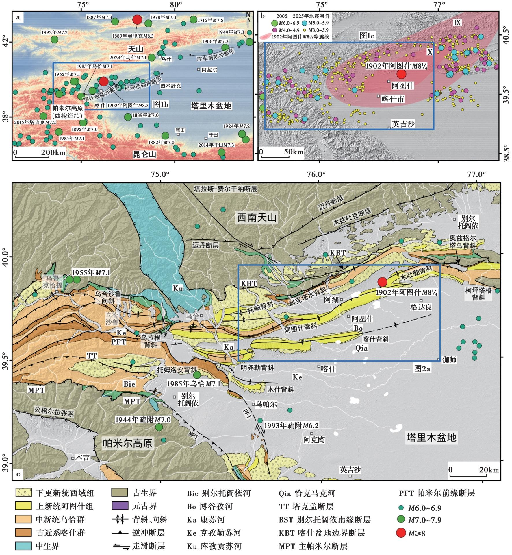
Fig. 1 Regional tectonic geologic map.
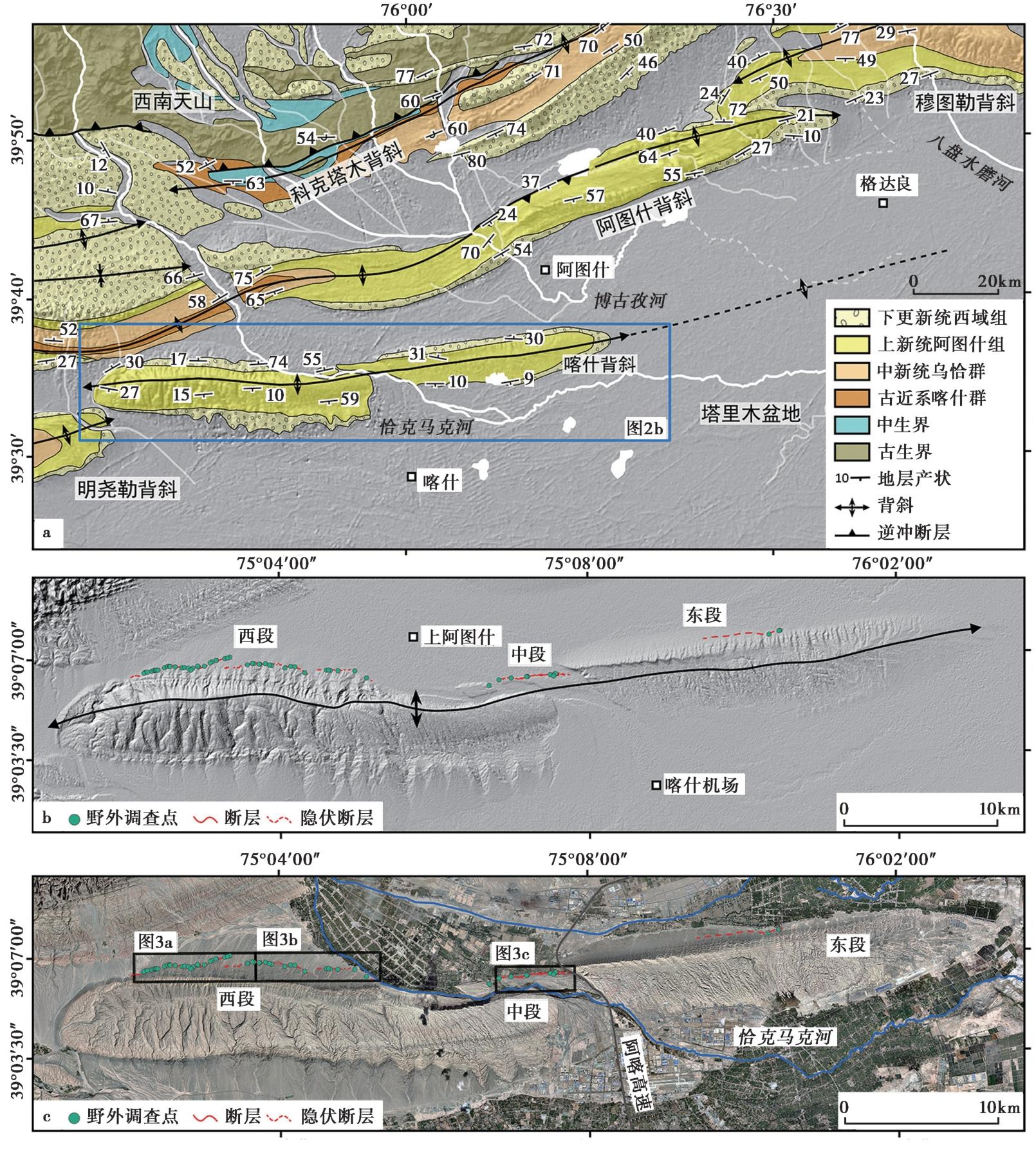
Fig. 2 Kashi anticline.
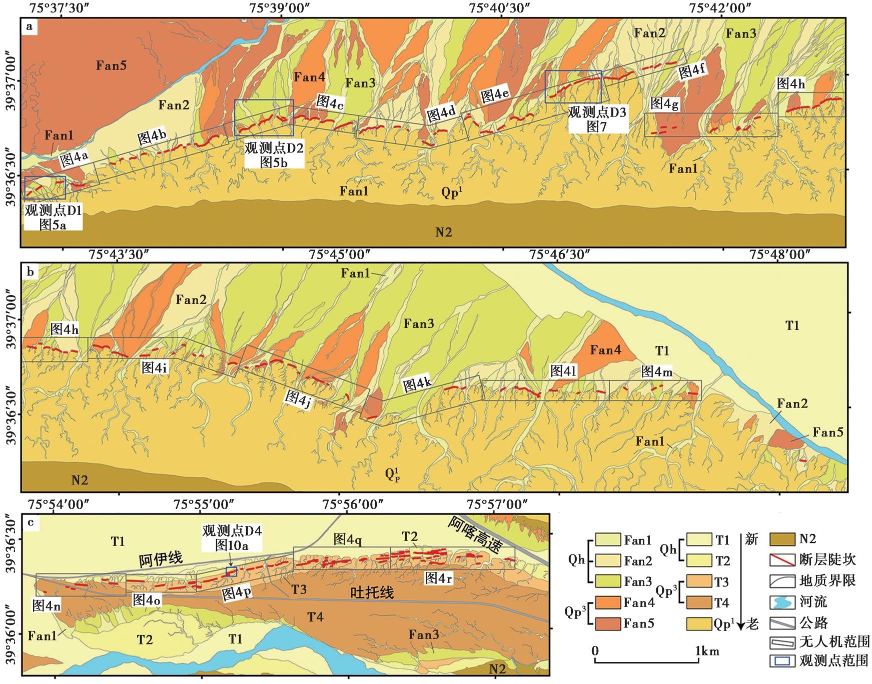
Fig. 3 Fault spreading map of north limb of Kashi anticline.

Fig. 4 Hillshade map of the north limb of Kashi anticline.
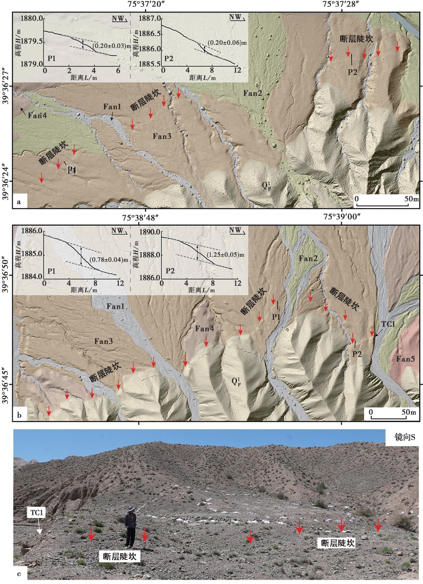
Fig. 5 Observation point D1 and D2.
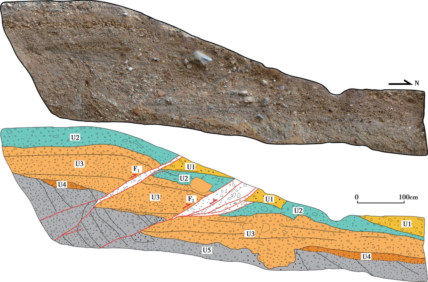
Fig. 6 Photomosaic and interpretation map of TC1.
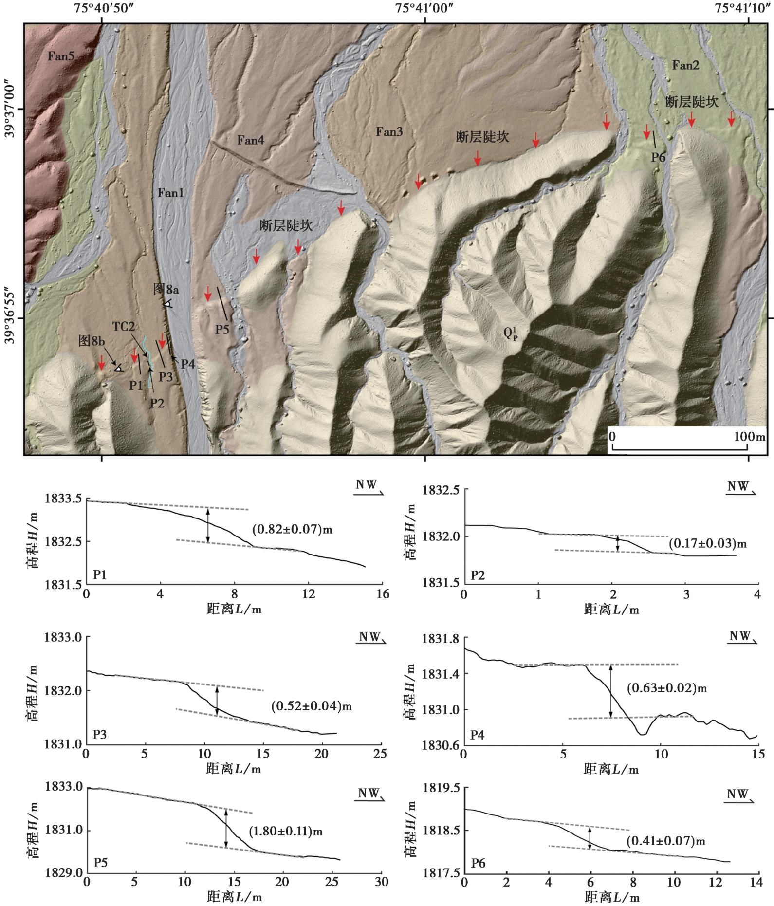
Fig. 7 Geomorphic surface interpretation and scarp profiles of observation point D3.
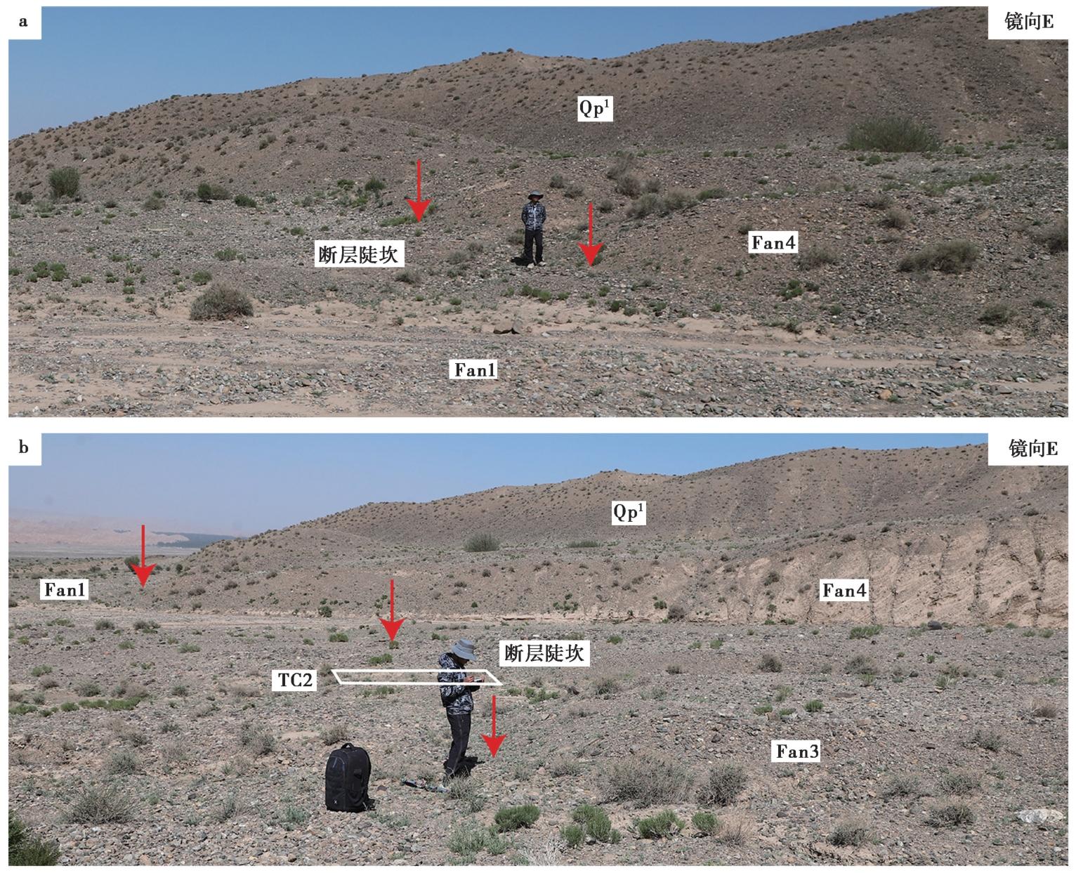
Fig. 8 Fault features of observation point D3.
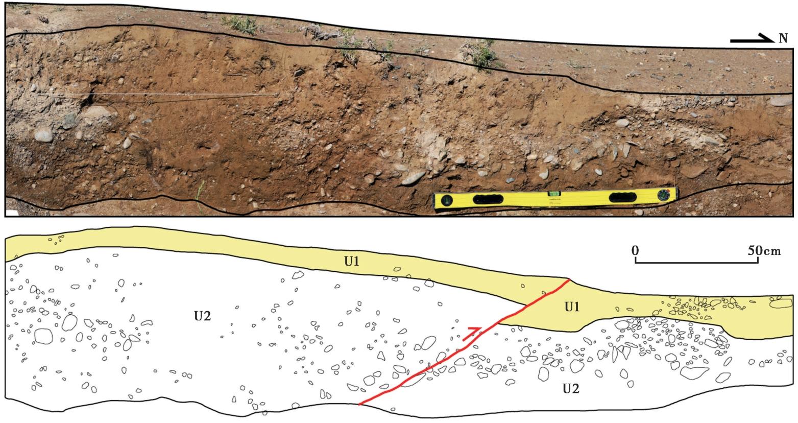
Fig. 9 Photomosaic and interpretation map of TC2 west wall.
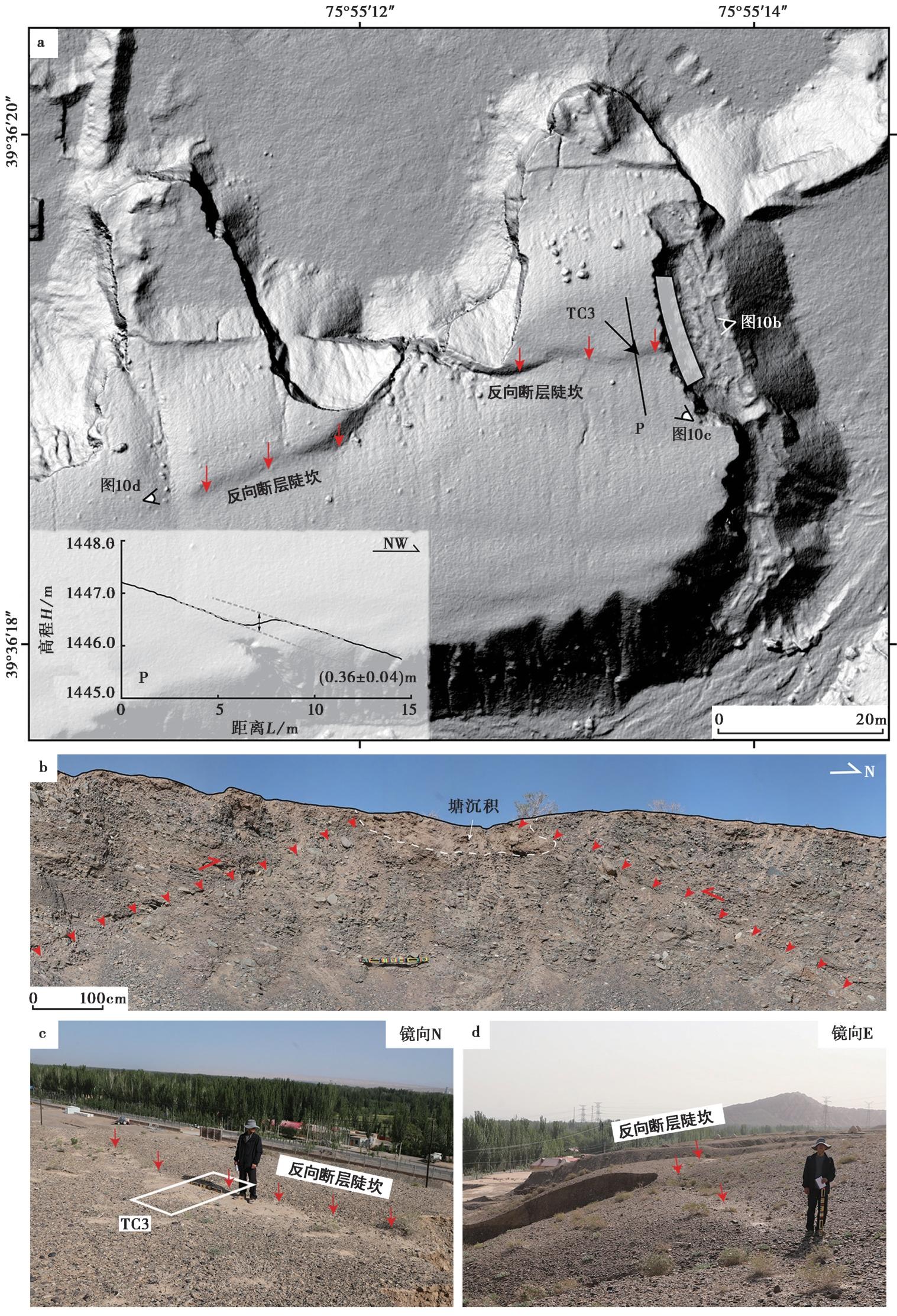
Fig. 10 Observation point D4.
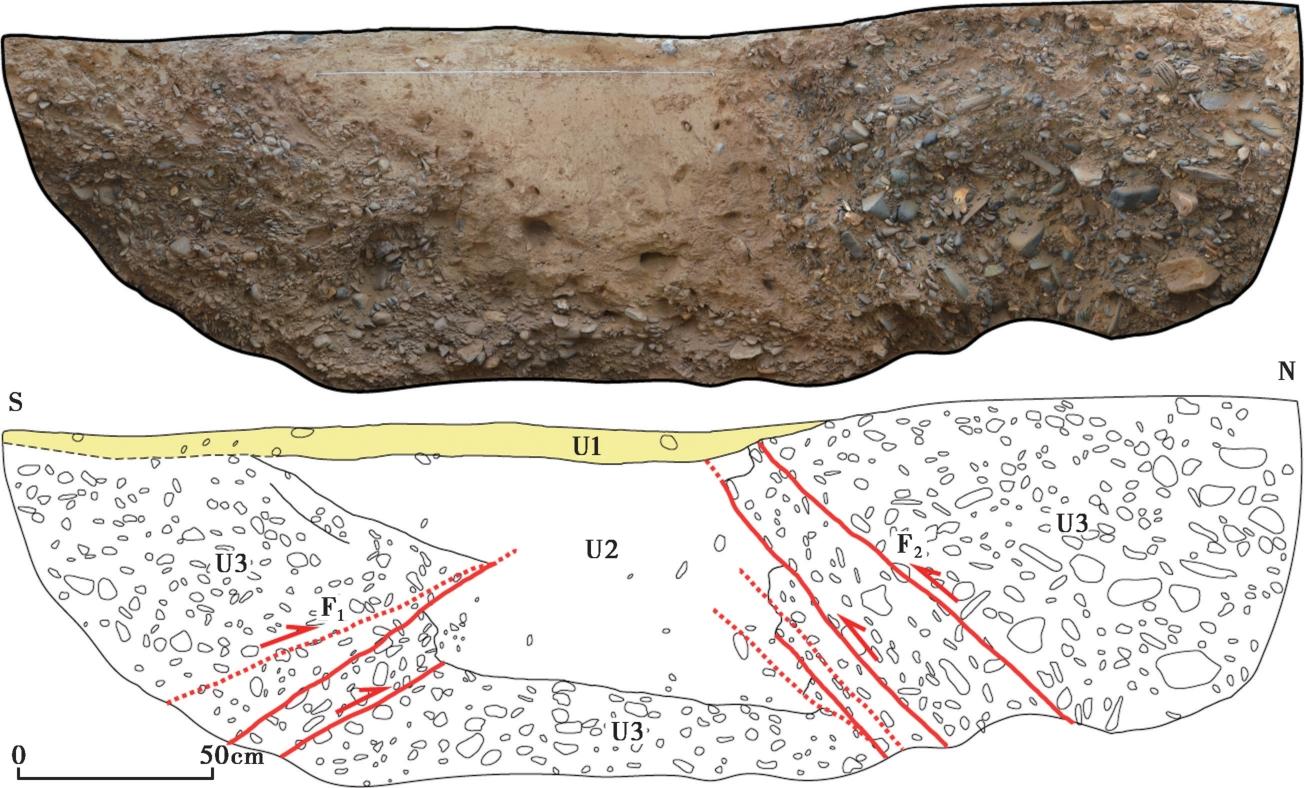
Fig. 11 Photomosaic and interpretation map of TC3 west wall.
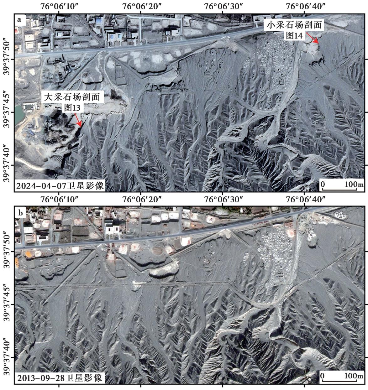
Fig. 12 Comparison of present-day images(a) and historical images(b) of the large quarry and the small quarry.
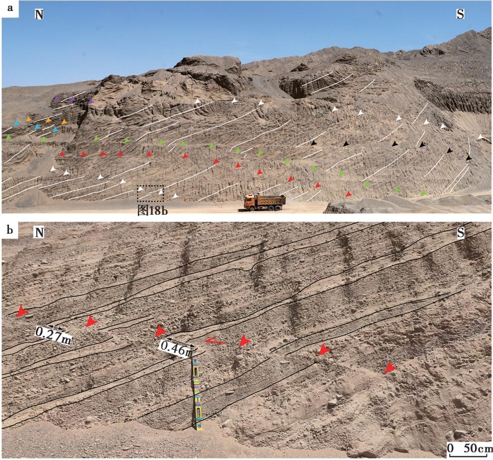
Fig. 13 Large quarry profile.
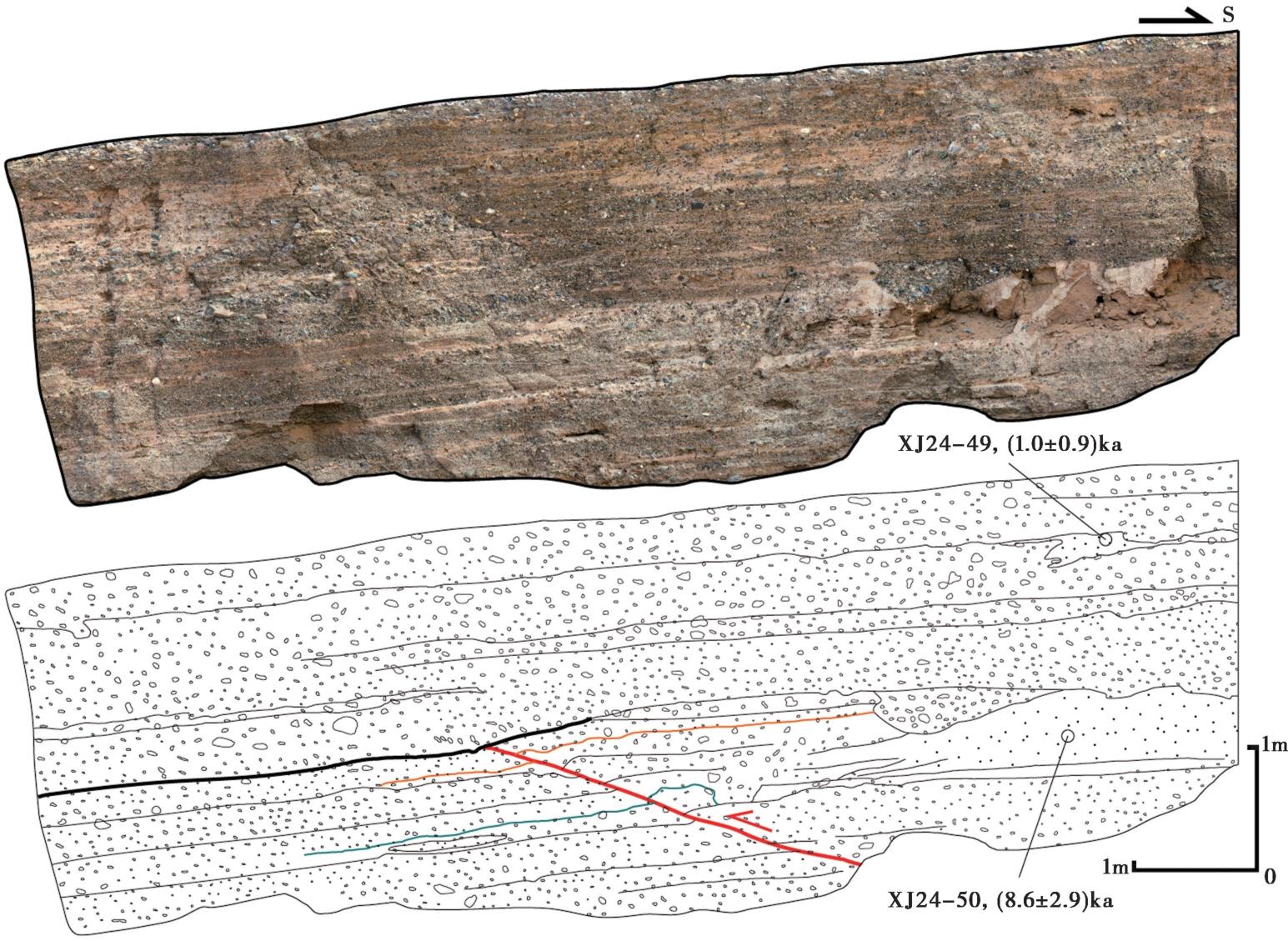
Fig. 14 Photomosaic and interpretation map of small quarry profile.
| 野外编号 | 实验编号 | 埋深 /m | 测量 方法 | 粒径 /μm | 238U /Bg·kg-1 | 266Ra /Bg·kg-1 | 232Th /Bg·kg-1 | 40K /Bg·kg-1 | 含水量/% | 环境 剂量率 /Gy·ka-1 | 等效 剂量 /Gy | 年龄 /ka |
|---|---|---|---|---|---|---|---|---|---|---|---|---|
| XJ24-49 | LED24-372 | 0.61 | SAR | 90~180 | 13.4±7.9 | 17.3±0.6 | 18.6±0.4 | 326.2±7.5 | 1 | 1.7±0.2 | 1.6±1.5 | 1.0±0.9 |
| XJ24-50 | LED24-373 | 2.2 | SAR | 90~180 | 14.8±5.9 | 14.4±0.4 | 15.1±0.3 | 359.8±7.3 | 0 | 1.6±0.2 | 14.1±4.5 | 8.6±2.8 |
Table1 Age table for Optically Stimulated Luminescence(OSL)samples in TC4
| 野外编号 | 实验编号 | 埋深 /m | 测量 方法 | 粒径 /μm | 238U /Bg·kg-1 | 266Ra /Bg·kg-1 | 232Th /Bg·kg-1 | 40K /Bg·kg-1 | 含水量/% | 环境 剂量率 /Gy·ka-1 | 等效 剂量 /Gy | 年龄 /ka |
|---|---|---|---|---|---|---|---|---|---|---|---|---|
| XJ24-49 | LED24-372 | 0.61 | SAR | 90~180 | 13.4±7.9 | 17.3±0.6 | 18.6±0.4 | 326.2±7.5 | 1 | 1.7±0.2 | 1.6±1.5 | 1.0±0.9 |
| XJ24-50 | LED24-373 | 2.2 | SAR | 90~180 | 14.8±5.9 | 14.4±0.4 | 15.1±0.3 | 359.8±7.3 | 0 | 1.6±0.2 | 14.1±4.5 | 8.6±2.8 |
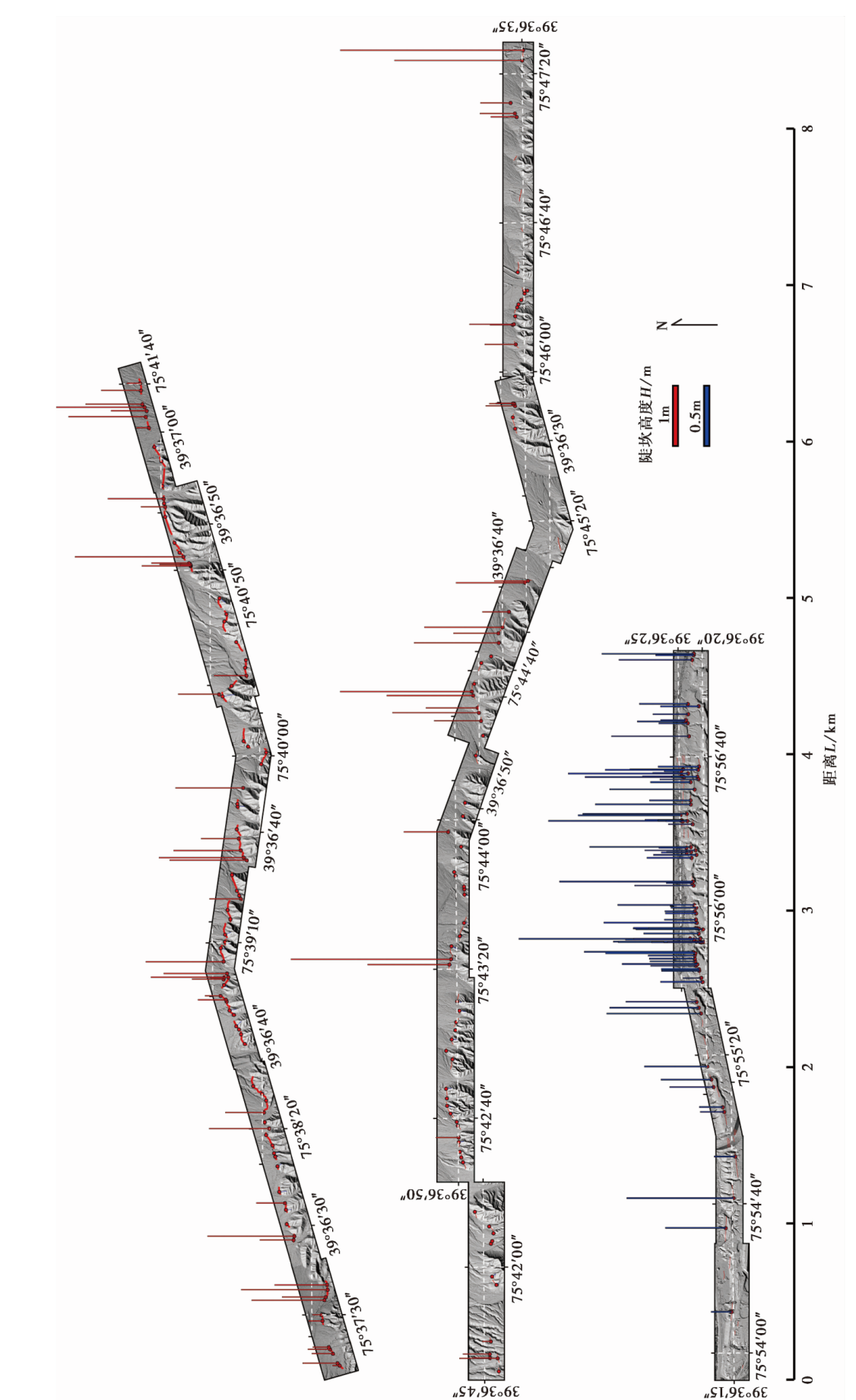
Fig. 15 Height distribution map of tectonic fault scarps along the northern flank of the Kashi anticlin.
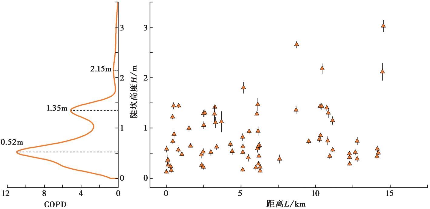
Fig. 16 Vertical displacement distribution of younger geomorphic surfaces along the western segment of the northern flank fault of the Kashi Anticline and corresponding COPD.
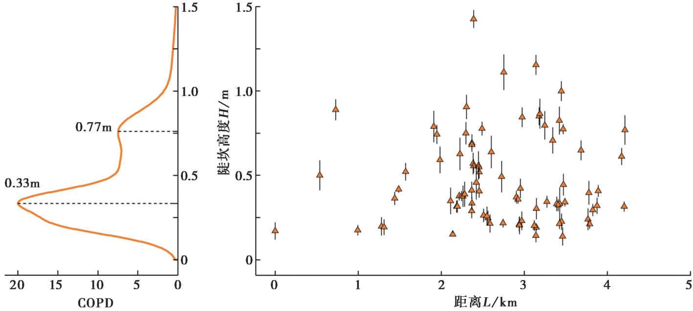
Fig. 17 Vertical displacement distribution along the central segment of the northern flank fault of the Kashi Anticline and corresponding COPD.
| [1] |
柏美祥, 戈澍漠. 1988. 1902年新疆阿图什 8¼ 级地震[A]// 郭增建. 中国特大地震研究(一). 北京: 地震出版社: 143-170.
|
|
|
|
| [2] |
陈杰, 李涛, 李文巧, 等. 2011. 帕米尔构造结及邻区的晚新生代构造与现今变形[J]. 地震地质, 33(2): 241-259. doi: 10.3969/j.issn.0253-4967.2011.02.001.
|
|
DOI |
|
| [3] |
陈杰, 李涛, 杨晓东, 等. 2017. 塔里木西缘木什、 明尧勒、 喀什活动逆断裂-背斜带活断层分布图(1︰50 000)与说明书[M]. 北京: 地震出版社.
|
|
|
|
| [4] |
陈杰, 曲国胜, 胡军, 等. 1997. 帕米尔北缘弧形推覆构造带东段的基本特征与现代地震活动[J]. 地震地质, 19(4): 301-312.
|
|
|
|
| [5] |
邓起东. 1994. 活动断裂研究理论与应用(3)[M]. 北京: 地震出版社.
|
|
|
|
| [6] |
胡伟华, 常想德, 伊力亚尔·阿不力孜, 等. 2018. 1902年8月22日新疆阿图什 8¼ 级地震地表破裂带及西南天山山前活动构造格局[J]. 内陆地震, 32(4): 289-308.
|
|
|
|
| [7] |
李涛. 2016. 南天山喀什前陆冲断带构造特征、 演化历史和控制因素[R]. 中国石油勘探开发研究院.
|
|
|
|
| [8] |
田勤俭, 丁国瑜, 郝平. 2006. 南天山及塔里木北缘构造带西段地震构造研究[J]. 地震地质, 28(2): 213-223.
|
|
|
|
| [9] |
杨晓平, 冉洪流. 2010. 活动推覆构造区潜在震源的边界和震级上限: 以1902年阿图什 8¼ 级地震构造区为例[J]. 震灾防御技术, 5(2): 145-156.
|
|
|
|
| [10] |
杨晓平, 冉勇康, 程建武, 等. 2006. 柯坪推覆构造中的几个新生褶皱带阶地变形测量与地壳缩短[J]. 中国科学(D辑), 36(10): 905-913.
|
|
|
|
| [11] |
张培震, 邓起东, 徐锡伟, 等. 1994. 盲断裂、 褶皱地震与新疆1906年玛纳斯地震[J]. 地震地质, 16(3): 193-204.
|
|
|
|
| [12] |
DOI URL |
| [13] |
|
| [14] |
|
| [15] |
|
| [16] |
DOI URL |
| [17] |
|
| [18] |
DOI URL |
| [19] |
DOI URL |
| [20] |
|
| [21] |
DOI URL |
| [22] |
DOI |
| [23] |
DOI URL |
| [24] |
DOI |
| [25] |
DOI URL |
| [26] |
DOI URL |
| [27] |
DOI URL |
| [28] |
|
| [29] |
|
| [30] |
DOI URL |
| [31] |
DOI URL |
| [32] |
|
| [33] |
DOI URL |
| [34] |
DOI URL |
| [35] |
DOI URL |
| [36] |
DOI URL |
| [37] |
DOI URL |
| [38] |
PMID |
| [39] |
|
| [40] |
DOI PMID |
| [41] |
DOI URL |
| [42] |
DOI URL |
| [1] | FU Jun-dong, WU Hai-ying, ZHANG Jian-min, LU Zi-lin, XIA Nuan, LI Zhi-heng, WANG Lei, ZOU Qi-feng. LATE QUATERNARY ACTIVITY FEATURES OF THE NANLIU SEGMENT OF THE ANQIU-JUXIAN FAULT IN THE TANLU FAULT ZONE [J]. SEISMOLOGY AND GEOLOGY, 2026, 48(3): 757-773. |
| [2] | LIU Jia-xin, PEI Shun-ping, GUO Yi-cun. PN WAVE VELOCITY AND ANISOTROPY TOMOGRAPHY IN THE UPPERMOST MANTLE OF PAMIR PLATEAU AND ADJACENT REGIONS [J]. SEISMOLOGY AND GEOLOGY, 2025, 47(2): 547-560. |
| [3] | CUI Hua-wei, YIN Xin-zhong, CHEN Jiu-hui, GUO Biao, LI Tao, YAO Yuan, LI Shi-ying, JIA Zhen. CHARACTERISTICS OF SEISMICITY AND TECTONIC STRESS FIELD IN THE NORTHEASTERN REGION OF THE PAMIR PLATEAU [J]. SEISMOLOGY AND GEOLOGY, 2025, 47(2): 577-596. |
| [4] | WEI Zhan-yu, HE Hong-lin, DENG Ya-ting, XI Xi. THREE-DIMENSIONAL SURFACE COSEISMIC DISPLACEMENTS FROM DIFFERENCING PRE- AND POST-EARTHQUAKE TERRAIN POINT CLOUDS [J]. SEISMOLOGY AND GEOLOGY, 2025, 47(1): 167-188. |
| [5] | ZHANG Wei-heng, ZHANG Dong-sheng, CHEN Jie, TIAN Qin-jian, HE Wan-tong. THE RANGE OF DEFORMED ZONE BASED BY ACTIVE FAULT OFFSET BASED ON STATISTICAL ANALYSIS OF SURFACE RUPTURE ZONE WIDTH [J]. SEISMOLOGY AND GEOLOGY, 2025, 47(1): 345-366. |
| [6] | ZHANG Guo-xia, SUN Hao-yue, LI Wei, SUN Wen. EVIDENCE FOR THE HOLOCENE ACTIVITY OF THE LEIBO FAULT ZONE [J]. SEISMOLOGY AND GEOLOGY, 2024, 46(1): 141-161. |
| [7] | WANG Mao-mao, HU Shun-yang, MA Hao-ran, LIANG Bo-yu, ZHANG Jin-yu, LU Ren-qi. 3D STRUCTURAL MODELLING OF THE ANNINGHE-ZEMUHE-XIAOJIANG FAULT ZONE IN THE EASTERN BOUNDARY OF SICHUAN-YUNNAN BLOCK USING MULTI-DATA AND IMPLICIT MODELING METHODS [J]. SEISMOLOGY AND GEOLOGY, 2024, 46(1): 19-34. |
| [8] | WU Xi-yan, LU Ren-qi, ZHANG Jin-yu, SUN Xiao, XU Fang, CHEN Gui-hua. A WEB-BASED PROTOTYPE SYSTEM FOR THE THREE-DIMENSIONAL FAULT MODELS OF THE CHINA SEISMIC EXPERIMENTAL SITE [J]. SEISMOLOGY AND GEOLOGY, 2024, 46(1): 35-47. |
| [9] | SHI Wen-fang, XU Wei, YIN Jin-hui, ZHENG Yong-gang. THE IMPROVEMENT OF QUARTZ SEPARATION PROCESS IN TCN DATING [J]. SEISMOLOGY AND GEOLOGY, 2023, 45(6): 1452-1462. |
| [10] | ZOU Jun-jie, HE Hong-lin, ZHOU Yong-sheng, WEI Zhan-yu, SHI Feng, GENG Shuang, SU Peng, SUN Wen. APPLICATION OF SMALL UNMANNED AERIAL VEHICLE(sUAV)IN THE SELECTION OF SUITABLE SITES IN PALEO-SEISMIC STUDY OF BEDROCK FAULT SURFACES [J]. SEISMOLOGY AND GEOLOGY, 2023, 45(4): 833-846. |
| [11] | ZHANG Hao, LI Li-mei, JIANG Xin, ZHANG Dong, XU Han-gang. NEW PROGRESS IN PALEOEARTHQUAKE STUDIES OF THE JIANGSU SEGMENT OF THE ANQIU-JUXIAN FAULT IN THE TANLU FAULT ZONE [J]. SEISMOLOGY AND GEOLOGY, 2023, 45(4): 880-895. |
| [12] | LIU Qing, LIU Shao, ZHANG Shi-min. PALEOSEISMOLOGIC STUDY ON THE YUEXI FAULT IN THE MIDSECTION OF THE DALIANGSHAN FAULT ZONE SINCE THE LATE QUATERNARY [J]. SEISMOLOGY AND GEOLOGY, 2023, 45(2): 321-337. |
| [13] | LI Yi-shi. RESEARCH ON COMPREHENSIVE STANDARDIZATION FOR SURVEYING AND PROSPECTING OF ACTIVE FAULT [J]. SEISMOLOGY AND GEOLOGY, 2023, 45(2): 455-463. |
| [14] | YANG Chen-yi, LI Xiao-ni, FENG Xi-jie, HUANG Yin-di, PEI Gen-di. SHALLOW STRUCTURE AND QUATERNARY ACTIVITY OF THE TAOCHUAN-HUXIAN FAULT, THE SUB-STRAND OF THE NORTHERN QINLING FAULT ZONE [J]. SEISMOLOGY AND GEOLOGY, 2023, 45(2): 464-483. |
| [15] | LI An, WAN Bo, WANG Xiao-xian, JI Hao-min, SUO Rui. NEW EVIDENCE OF THE PALEOEARTHQUAKE RUPTURE IN THE NORTH GAIZHOU-ANSHAN SEGMENT OF THE JINZHOU FAULT [J]. SEISMOLOGY AND GEOLOGY, 2023, 45(1): 111-126. |
| Viewed | ||||||
|
Full text |
|
|||||
|
Abstract |
|
|||||
Copyright © SEISMOLOGY AND GEOLOGY, All Rights Reserved.
Tel: 010-62009049/9063 E-mail: dzdz@ies.ac.cn
Powered by Beijing Magtech Co., Ltd.