
SEISMOLOGY AND GEOLOGY ›› 2026, Vol. 48 ›› Issue (3): 757-773.DOI: 10.3969/j.issn.0253-4967.20240164
• Research paper • Previous Articles Next Articles
LATE QUATERNARY ACTIVITY FEATURES OF THE NANLIU SEGMENT OF THE ANQIU-JUXIAN FAULT IN THE TANLU FAULT ZONE
FU Jun-dong1)( ), WU Hai-ying2),*(), ZHANG Jian-min1), LU Zi-lin1), XIA Nuan1), LI Zhi-heng1,3), WANG Lei1,4), ZOU Qi-feng5)
- 1)
Shandong Earthquake Agency
2)Liaocheng Housing and Construction Development Support Center
3)Institute of Geophysics ,China Earthquake Administration
4)State Key Laboratory of Earthquake Dynamics and Forecasting ,Institute of Geology, China Earthquake Administration
5)Shandong Luzhen Science and Technology Engineering Limited Liability Company
-
Received:2025-02-23Revised:2025-06-09Online:2026-06-20Published:2026-07-09
郯庐断裂带安丘-莒县断裂南流段晚第四纪活动特征
付俊东1)(), 吴海英2),*(), 张建民1), 鹿子林1), 夏暖1), 李志恒1,3), 王雷1,4), 邹奇峰5)
- 1)
山东省地震局
2)聊城市住房与建设事业保障中心
3)中国地震局地球物理研究所
4)地震动力学与强震预测全国重点实验室(中国地震局地质研究所)
5)山东省鲁震科技工程有限公司
-
通讯作者:*吴海英, 女, 1976年生, 硕士, 高级工程师, 从事建筑工程抗震与震害防御研究, E-mail: whydmm@163.com。 -
作者简介:付俊东, 男, 1986年生, 2012年于中国地震局地震预测研究所获构造地质学硕士学位, 高级工程师, 主要从事活动构造研究, E-mail: 721824801@qq.com。
-
基金资助:山东郯城巨震区低速率挤压逆冲构造野外科学观测研究站; 中国地震局地震科技星火计划项目(XH25014YA); 山东省地震局地震构造团队和山东省地震局重点业务专项(YW2305); 山东省地震局地震构造团队和山东省地震局重点业务专项(YW2303)

Cite this article
FU Jun-dong, WU Hai-ying, ZHANG Jian-min, LU Zi-lin, XIA Nuan, LI Zhi-heng, WANG Lei, ZOU Qi-feng. LATE QUATERNARY ACTIVITY FEATURES OF THE NANLIU SEGMENT OF THE ANQIU-JUXIAN FAULT IN THE TANLU FAULT ZONE[J]. SEISMOLOGY AND GEOLOGY, 2026, 48(3): 757-773.
付俊东, 吴海英, 张建民, 鹿子林, 夏暖, 李志恒, 王雷, 邹奇峰. 郯庐断裂带安丘-莒县断裂南流段晚第四纪活动特征[J]. 地震地质, 2026, 48(3): 757-773.
share this article
Add to citation manager EndNote|Ris|BibTeX
URL: https://www.dzdz.ac.cn/EN/10.3969/j.issn.0253-4967.20240164

Fig. 1 Map of historical earthquake distribution along the Tanlu fault zone and its surrounding areas.

Fig. 2 Distribution of faults and modern earthquake density in the Yishu fault zone.

Fig. 3 Distribution of the Nanliu segment of the Anqiu-Juxian Fault.
| 编号 | 起点坐标 | 终点坐标 | 长度 | 道距 /m | 最小偏移 /m | 接收 道数 | 覆盖 次数 | 记录长度 /ms |
|---|---|---|---|---|---|---|---|---|
| C1 | 36.609°N, 119.314°E | 36.612°N, 119.333°E | 1766 | 2 | 16 | 96 | 12 | 2000 |
| C2 | 36.574°N, 119.285°E | 36.573°N, 119.312°E | 2494 | 2 | 24 | 72 | 9 | 1000 |
Table1 The parameters of shallow seismic exploration lines
| 编号 | 起点坐标 | 终点坐标 | 长度 | 道距 /m | 最小偏移 /m | 接收 道数 | 覆盖 次数 | 记录长度 /ms |
|---|---|---|---|---|---|---|---|---|
| C1 | 36.609°N, 119.314°E | 36.612°N, 119.333°E | 1766 | 2 | 16 | 96 | 12 | 2000 |
| C2 | 36.574°N, 119.285°E | 36.573°N, 119.312°E | 2494 | 2 | 24 | 72 | 9 | 1000 |
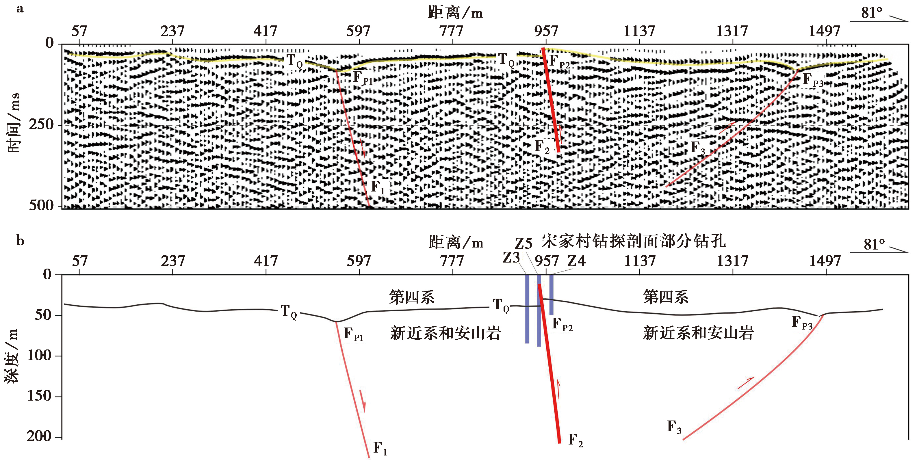
Fig. 4 Stacked time section(a) and depth interpretation(b) of shallow seismic survey line C1.
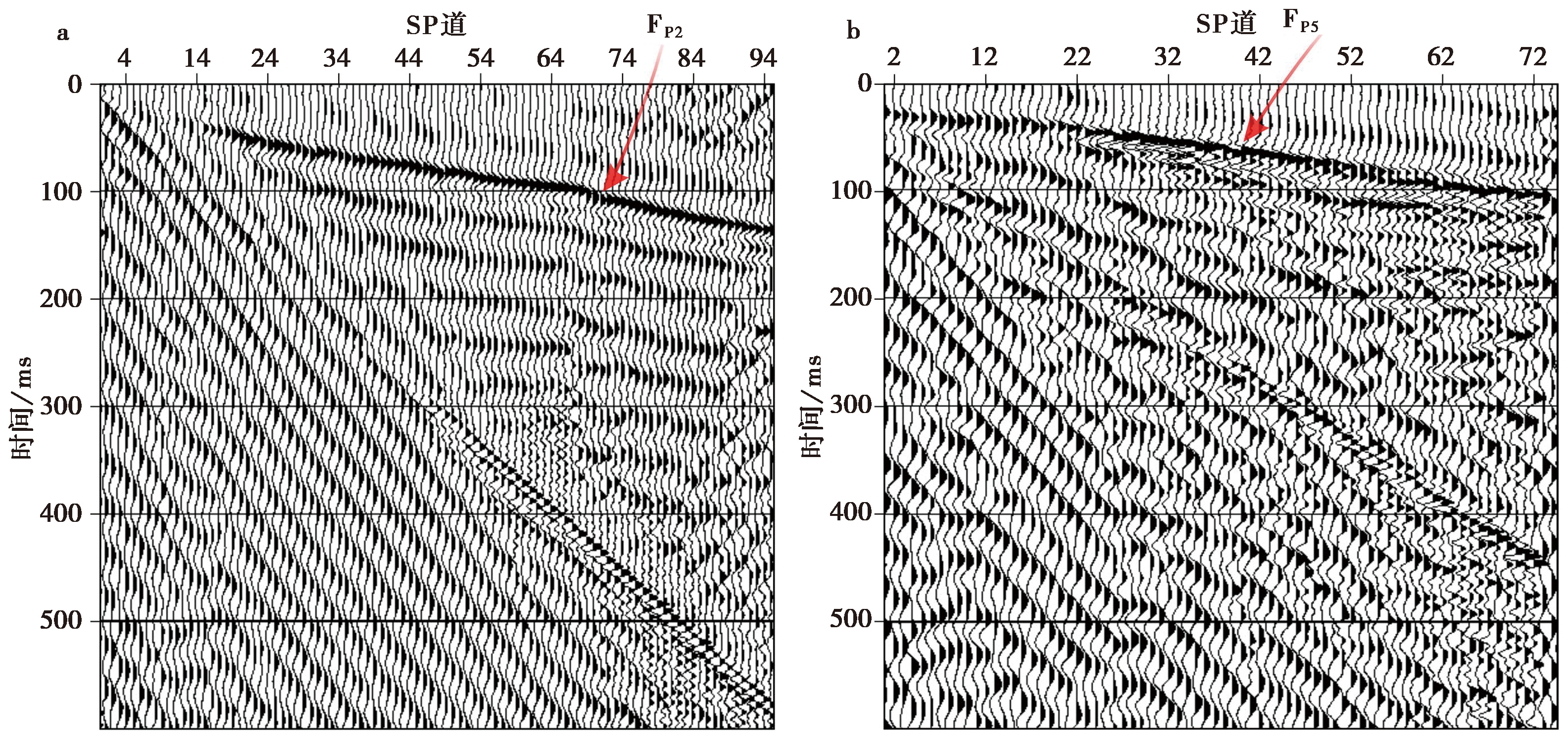
Fig. 5 The common-shot gathers of the shallow seismic reflection near the breakpoints of line C1(a) and C2(b).
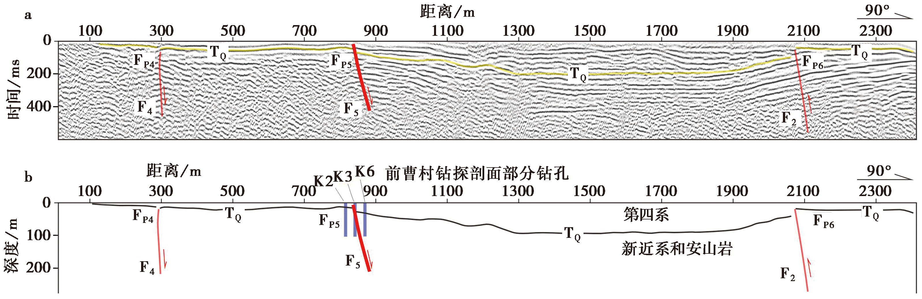
Fig. 6 Stacked time section(a) and depth interpretation(b) of shallow seismic survey line C2.
| 样品编号 | 野外编号 | 岩性 | 埋深 /m | 环境剂量率 /Gy·ka-1 | 等效剂量 /Gy | 释光年龄 /ka | 样品 来源 |
|---|---|---|---|---|---|---|---|
| 2023-0039 | K2-OSL-2 | 粉土 | 4.5 | 2.5±0.3 | 118.6±7.0 | 47.5±2.8 | 前曹村钻孔联合地质剖面 |
| 2023-0040 | K2-OSL-4 | 粉质黏土 | 8.3 | 2.4±0.3 | 132.1±8.2 | 54.8±3.4 | |
| 2023-0041 | K2-OSL-7 | 粉质黏土 | 13.35 | 2.3±0.3 | 179.6±7.3 | 78.4±3.2 | |
| 2023-0042 | K3-OSL-2 | 粉土 | 3.3 | 2.5±0.3 | 120.6±5.5 | 48.2±2.2 | |
| 2023-0043 | K3-OSL-11 | 粉细砂 | 23.8 | 2.3±0.3 | 171.9±10.2 | 75.7±4.5 | |
| 2023-0044 | K7-OSL-4 | 粉土 | 9.2 | 2.2±0.3 | 136.6±5.4 | 61.0±2.4 | |
| 2023-0045 | K7-OSL-9 | 粉质黏土 | 22.9 | 2.0±0.3 | 161.8±4.6 | 80.1±2.3 | |
| 2023-0051 | Z3-OSL-3 | 粉土 | 5.8 | 2.2±0.3 | 128.7±7.0 | 58.2±3.2 | 宋家村钻孔联合地质剖面 |
| 2023-0052 | Z3-OSL-6 | 粉质黏土 | 12.35 | 2.1±0.3 | 144.2±4.7 | 67.7±2.2 | |
| 2023-0053 | Z3-OSL-8 | 粉质黏土 | 18.55 | 2.2±0.3 | 155.5±6.9 | 72.0±3.2 | |
| 2023-0054 | Z3-OSL-11 | 粉质黏土 | 27 | 2.1±0.3 | 169.4±7.0 | 80.7±3.3 | |
| 2023-0055 | Z3-OSL-13 | 粉质黏土 | 36.4 | 1.9±0.3 | 180.5±7.0 | 95.0±3.7 | |
| 2023-0056 | Z3-OSL-15 | 粉质黏土 | 49.25 | 1.9±0.3 | 198.9±8.2 | 104.7±4.3 | |
| 2023-0057 | Z3-OSL-17 | 粉质黏土 | 63.7 | 1.3±0.3 | 165.0±7.0 | 126.9±5.4 | |
| 2023-0058 | Z4-OSL-2 | 粉质黏土 | 3.9 | 2.1±0.3 | 121.3±5.4 | 57.5±2.6 | |
| 2023-0059 | Z4-OSL-6 | 砾石土 | 11.65 | 2.3±0.3 | 149.1±4.9 | 64.0±2.1 | |
| 2023-0060 | Z4-OSL-7 | 粉质黏土 | 13.45 | 2.3±0.3 | 160.3±4.8 | 70.6±2.1 | |
| 2023-0061 | Z4-OSL-12 | 粉砂 | 27.3 | 1.5±0.3 | 195.2±15.3 | 130.2±10.2 | |
| 2023-0062 | Z7-OSL-3 | 含姜石粉质黏土 | 14.6 | 2.1±0.3 | 159.6±4.7 | 74.6±2.2 | |
| 2023-0075 | Z3-OSL-1 | 粉土 | 2.1 | 2.4±0.3 | 44.1±4.7 | 18.3±2.0 | |
| 2023-0076 | Z3-OSL-2 | 粉土 | 3.7 | 2.5±0.3 | 134.7±7.3 | 53.9±2.9 |
Table2 Dating results of the OSL samples
| 样品编号 | 野外编号 | 岩性 | 埋深 /m | 环境剂量率 /Gy·ka-1 | 等效剂量 /Gy | 释光年龄 /ka | 样品 来源 |
|---|---|---|---|---|---|---|---|
| 2023-0039 | K2-OSL-2 | 粉土 | 4.5 | 2.5±0.3 | 118.6±7.0 | 47.5±2.8 | 前曹村钻孔联合地质剖面 |
| 2023-0040 | K2-OSL-4 | 粉质黏土 | 8.3 | 2.4±0.3 | 132.1±8.2 | 54.8±3.4 | |
| 2023-0041 | K2-OSL-7 | 粉质黏土 | 13.35 | 2.3±0.3 | 179.6±7.3 | 78.4±3.2 | |
| 2023-0042 | K3-OSL-2 | 粉土 | 3.3 | 2.5±0.3 | 120.6±5.5 | 48.2±2.2 | |
| 2023-0043 | K3-OSL-11 | 粉细砂 | 23.8 | 2.3±0.3 | 171.9±10.2 | 75.7±4.5 | |
| 2023-0044 | K7-OSL-4 | 粉土 | 9.2 | 2.2±0.3 | 136.6±5.4 | 61.0±2.4 | |
| 2023-0045 | K7-OSL-9 | 粉质黏土 | 22.9 | 2.0±0.3 | 161.8±4.6 | 80.1±2.3 | |
| 2023-0051 | Z3-OSL-3 | 粉土 | 5.8 | 2.2±0.3 | 128.7±7.0 | 58.2±3.2 | 宋家村钻孔联合地质剖面 |
| 2023-0052 | Z3-OSL-6 | 粉质黏土 | 12.35 | 2.1±0.3 | 144.2±4.7 | 67.7±2.2 | |
| 2023-0053 | Z3-OSL-8 | 粉质黏土 | 18.55 | 2.2±0.3 | 155.5±6.9 | 72.0±3.2 | |
| 2023-0054 | Z3-OSL-11 | 粉质黏土 | 27 | 2.1±0.3 | 169.4±7.0 | 80.7±3.3 | |
| 2023-0055 | Z3-OSL-13 | 粉质黏土 | 36.4 | 1.9±0.3 | 180.5±7.0 | 95.0±3.7 | |
| 2023-0056 | Z3-OSL-15 | 粉质黏土 | 49.25 | 1.9±0.3 | 198.9±8.2 | 104.7±4.3 | |
| 2023-0057 | Z3-OSL-17 | 粉质黏土 | 63.7 | 1.3±0.3 | 165.0±7.0 | 126.9±5.4 | |
| 2023-0058 | Z4-OSL-2 | 粉质黏土 | 3.9 | 2.1±0.3 | 121.3±5.4 | 57.5±2.6 | |
| 2023-0059 | Z4-OSL-6 | 砾石土 | 11.65 | 2.3±0.3 | 149.1±4.9 | 64.0±2.1 | |
| 2023-0060 | Z4-OSL-7 | 粉质黏土 | 13.45 | 2.3±0.3 | 160.3±4.8 | 70.6±2.1 | |
| 2023-0061 | Z4-OSL-12 | 粉砂 | 27.3 | 1.5±0.3 | 195.2±15.3 | 130.2±10.2 | |
| 2023-0062 | Z7-OSL-3 | 含姜石粉质黏土 | 14.6 | 2.1±0.3 | 159.6±4.7 | 74.6±2.2 | |
| 2023-0075 | Z3-OSL-1 | 粉土 | 2.1 | 2.4±0.3 | 44.1±4.7 | 18.3±2.0 | |
| 2023-0076 | Z3-OSL-2 | 粉土 | 3.7 | 2.5±0.3 | 134.7±7.3 | 53.9±2.9 |
| 实验室编号 | 野外编号 | 石墨量/mg | 现代碳比值Fm值 | Δ14C | 14C年龄 |
|---|---|---|---|---|---|
| 23061203OCSP | K8-14C-2 | 1.00 | 0.6304±0.0022 | -369.3±2.2 | (3705±30)aBP |
| 23061204OCSP | K7-14C-3 | 0.87 | 0.6292±0.0020 | -370.8±2.0 | (3720±30)aBP |
Table3 Dating results of the 14C samples
| 实验室编号 | 野外编号 | 石墨量/mg | 现代碳比值Fm值 | Δ14C | 14C年龄 |
|---|---|---|---|---|---|
| 23061203OCSP | K8-14C-2 | 1.00 | 0.6304±0.0022 | -369.3±2.2 | (3705±30)aBP |
| 23061204OCSP | K7-14C-3 | 0.87 | 0.6292±0.0020 | -370.8±2.0 | (3720±30)aBP |

Fig. 7 The drilling joint profile exploration at Songjia village.

Fig. 8 The drilling joint profile exploration at Qiancao village.
| [1] |
曹筠, 冉勇康, 许汉刚, 等. 2015. 宿迁城市活动断层探测多方法技术运用的典型案例[J]. 地震地质, 37(2): 430-439. doi: 10.3969/j.issn.0253-4967.2015.02.007.
|
|
DOI |
|
| [2] |
晁洪太, 李家灵, 崔昭文, 等. 1997a. 郯庐断裂带潍坊-嘉山段全新世活断层的活动方式与发震模式[J]. 地震研究, 20(4): 218-226.
|
|
|
|
| [3] |
晁洪太, 李家灵, 崔昭文, 等. 1997b. 与1668年郯城 8½级地震断层有关的几个问题讨论[J]. 华北地震科学, 15(4): 18-25.
|
|
|
|
| [4] |
邓起东, 陈立春, 冉勇康. 2004. 活动构造定量研究与应用[J]. 地学前缘, 11(4): 383-392.
|
|
|
|
| [5] |
邓起东, 徐锡伟, 张先康, 等. 2003. 城市活动断裂探测的方法和技术[J]. 地学前缘, 10(1): 93-104.
|
|
|
|
| [6] |
丁国瑜. 1989. 中国活断层图集[M]. 北京:地震出版社; 西安: 西安地图出版社.
|
|
|
|
| [7] |
方仲景, 丁梦林, 向宏发, 等. 1986. 郯庐断裂带的基本特征[J]. 科学通报, 31(1): 52-55.
|
|
|
|
| [8] |
付俊东, 王志才, 熊仁伟, 等. 2017. 安丘-莒县断裂小店-大店段断层活动证据及断层泥分布特征初步研究[J]. 地震, 37(2): 57-66.
|
|
|
|
| [9] |
高维明, 郑朗荪, 李家灵, 等. 1988. 1668年山东郯城8.5级地震的发震构造[J]. 中国地震, 4(3): 9-15.
|
|
|
|
| [10] |
国家地震局地质研究所. 1987. 郯庐断裂[M]. 北京: 地震出版社.
|
|
Institute of Geology State Seismological Bureau. 1987. The Tan-Lu Fault Zone[M]. Seismological Press, Beijing (in Chinese).
|
|
| [11] |
李家灵, 晁洪太, 崔昭文, 等. 1994. 1668年郯城 8½ 级地震断层及其破裂机制[J]. 地震地质, 16(3): 229-237.
|
|
|
|
| [12] |
李晓妮, 杨晨艺, 李高阳, 等. 2023. 渭河盆地东南缘渭南塬前北侧分支断层的浅部结构及晚第四纪活动[J]. 地震地质, 45(2): 484-499. doi: 10.3969/j.issn.0253-4967.2023.02.011.
|
|
DOI |
|
| [13] |
刘保金, 张先康, 方盛明, 等. 2002. 城市活断层探测的高分辨率浅层地震数据采集技术[J]. 地震地质, 24(4): 524-532.
|
|
|
|
| [14] |
刘华国, 吴小江, 李峰, 等. 2018. 马袅-铺前断裂中段全新世活动特征研究[J]. 震灾防御技术, 13(3): 588-599.
|
|
|
|
| [15] |
鹿子林, 葛孚刚, 薛俊召, 等. 2022. 滨北地区埕南断层晚更新世活动证据及其地震危险性意义[J]. 震灾防御技术, 17(2): 294-307.
|
|
|
|
| [16] |
石玉若, 康月蓝, 彭文骁. 2025. 深大断裂之郯庐断裂[J]. 地质学报, 99(1): 104-119.
|
|
|
|
| [17] |
疏鹏, 徐锡伟, 酆少英, 等. 2023. 板泉拉分盆地沉积-构造演化及其对郯庐断裂带新生代晚期右旋走滑运动的响应[J]. 中国科学(地球科学), 53(4): 784-805.
|
|
|
|
| [18] |
郯庐断裂带活动断裂带地质填图课题组. 2013. 郯庐活动断裂带地质图(1︰50 000)说明书[CM]. 北京: 地震出版社.
|
|
Active Fault Research Group of Geological Map of the Tanlu Fault Zone. 2013. Geological Map of the Activities of Tanlu Fault Zone(1︰50 000)[CM]. Seismological Press, Beijing (in Chinese).
|
|
| [19] |
万天丰, 朱鸿, 赵磊, 等. 1996. 郯庐断裂带的形成与演化: 综述[J]. 现代地质, 10(2): 159-168.
|
|
DOI URL |
|
| [20] |
王志才, 贾荣光, 孙昭民, 等. 2005. 沂沭断裂带安丘-莒县断裂安丘-朱里段几何结构与活动特征[J]. 地震地质, 27(2): 212-220.
|
|
|
|
| [21] |
吴中海. 2019. 活断层的定义与分类: 历史、现状和进展[J]. 地球学报, 40(5): 661-697.
|
|
|
|
| [22] |
向宏发. 2003. 隐伏活动构造探测研究的若干问题讨论[J]. 地震地质, 25(3): 460-466.
|
|
|
|
| [23] |
杨彬, 王华林, 吴洪斌, 等. 2023. 高精度LiDAR技术在活动断层断错地貌研究中的应用: 以沂沭断裂带莒县至郯城段为例[J]. 煤田地质与勘探, 51(12): 57-68.
|
|
|
|
| [24] |
张浩, 李丽梅, 蒋新, 等. 2023. 郯庐断裂带安丘-莒县断裂江苏段古地震研究新进展[J]. 地震地质, 45(4): 880-895. doi: 10.3969/j.issn.0253-4967.2023.04.005.
|
|
DOI |
|
| [25] |
郑朗荪, 高维明, 郑传贝. 1988. 郯庐断裂带的分段与沂沭断裂的活动性[J]. 中国地震, 4(3): 129-135.
|
|
|
|
| [26] |
朱光, 刘国生, 牛漫兰, 等. 2002. 郯庐断裂带晚第三纪以来的浅部挤压活动与深部过程[J]. 地震地质, 24(2): 265-277.
|
|
|
|
| [27] |
|
| [1] | WANG Xin, GAO Min, QIAO Ji-hua, XIANG Jian-bin, XU Yu-chen, FAN Ji-di. GRAVITY ISOSTASY AND DEEP SEISMOGENIC ENVIRONMENT IN THE MIDDLE SEGMENT OF THE TANLU FAULT ZONE [J]. SEISMOLOGY AND GEOLOGY, 2026, 48(3): 741-756. |
| [2] | LI Xi-bing, TAO Xiao-san, GU Qin-ping, PENG Xiao-bo, WANG Yu, ZHU Feng. P-WAVE VELOCITY STRUCTURE OF THE CRUST AND UPPER-MOST MANTLE IN THE CENTRAL AND SOUTHERN SEGMENT OF TANLU FAULT ZONE AND ITS TECTONIC IMPLICATION [J]. SEISMOLOGY AND GEOLOGY, 2026, 48(2): 423-441. |
| [3] | WEI Zhan-yu, HE Hong-lin, DENG Ya-ting, XI Xi. THREE-DIMENSIONAL SURFACE COSEISMIC DISPLACEMENTS FROM DIFFERENCING PRE- AND POST-EARTHQUAKE TERRAIN POINT CLOUDS [J]. SEISMOLOGY AND GEOLOGY, 2025, 47(1): 167-188. |
| [4] | ZHANG Wei-heng, ZHANG Dong-sheng, CHEN Jie, TIAN Qin-jian, HE Wan-tong. THE RANGE OF DEFORMED ZONE BASED BY ACTIVE FAULT OFFSET BASED ON STATISTICAL ANALYSIS OF SURFACE RUPTURE ZONE WIDTH [J]. SEISMOLOGY AND GEOLOGY, 2025, 47(1): 345-366. |
| [5] | WANG Mao-mao, HU Shun-yang, MA Hao-ran, LIANG Bo-yu, ZHANG Jin-yu, LU Ren-qi. 3D STRUCTURAL MODELLING OF THE ANNINGHE-ZEMUHE-XIAOJIANG FAULT ZONE IN THE EASTERN BOUNDARY OF SICHUAN-YUNNAN BLOCK USING MULTI-DATA AND IMPLICIT MODELING METHODS [J]. SEISMOLOGY AND GEOLOGY, 2024, 46(1): 19-34. |
| [6] | WU Xi-yan, LU Ren-qi, ZHANG Jin-yu, SUN Xiao, XU Fang, CHEN Gui-hua. A WEB-BASED PROTOTYPE SYSTEM FOR THE THREE-DIMENSIONAL FAULT MODELS OF THE CHINA SEISMIC EXPERIMENTAL SITE [J]. SEISMOLOGY AND GEOLOGY, 2024, 46(1): 35-47. |
| [7] | ZHANG Hao, LI Li-mei, JIANG Xin, ZHANG Dong, XU Han-gang. NEW PROGRESS IN PALEOEARTHQUAKE STUDIES OF THE JIANGSU SEGMENT OF THE ANQIU-JUXIAN FAULT IN THE TANLU FAULT ZONE [J]. SEISMOLOGY AND GEOLOGY, 2023, 45(4): 880-895. |
| [8] | ZHAO Peng, LI Jun-hui, TAO Yue-chao, SHU Peng, FANG Zhen. NEW ACTIVITY PHENOMENA REVEALED BY TRENCH ON THE NORTH SIDE OF NÜSHAN LAKE IN THE TANLU FAULT ZONE AND DISCUSSION [J]. SEISMOLOGY AND GEOLOGY, 2023, 45(2): 338-354. |
| [9] | LI Yi-shi. RESEARCH ON COMPREHENSIVE STANDARDIZATION FOR SURVEYING AND PROSPECTING OF ACTIVE FAULT [J]. SEISMOLOGY AND GEOLOGY, 2023, 45(2): 455-463. |
| [10] | YANG Chen-yi, LI Xiao-ni, FENG Xi-jie, HUANG Yin-di, PEI Gen-di. SHALLOW STRUCTURE AND QUATERNARY ACTIVITY OF THE TAOCHUAN-HUXIAN FAULT, THE SUB-STRAND OF THE NORTHERN QINLING FAULT ZONE [J]. SEISMOLOGY AND GEOLOGY, 2023, 45(2): 464-483. |
| [11] | TIAN Yi-ming, YANG Zhuo-xin, WANG Zhi-shuo, SHI Jin-hu, ZHANG Yang, TAN Ya-li, ZHANG Jian-zhi, SONG Wei, JI Tong-yu. A PRELIMINARY STUDY OF THE SHALLOW EXPLORATION AND QUATERNARY ACTIVITIES OF THE FENGQIU SEGMENT OF THE XINXIANG-SHANGQIU FAULT [J]. SEISMOLOGY AND GEOLOGY, 2023, 45(1): 139-152. |
| [12] | YANG Yuan-yuan, LI Peng-fei, LU Shuo, SHU Peng, PAN Hao-bo, FANG Liang-hao, ZHENG Hai-gang, ZHAO Peng, ZHENG Ying-ping, YAO Da-quan. PALEOEARTHQUAKES AND VERTICAL SLIP RATES ON THE HUAI RIVER-NÜSHAN LAKE SEGMENT OF FAULT F5 IN THE MIDDLE SECTION OF THE TANLU FAULT ZONE [J]. SEISMOLOGY AND GEOLOGY, 2022, 44(6): 1365-1383. |
| [13] | ZHANG Hao, WANG Jin-yan, XU Han-gang, LI Li-mei, JIANG Xin, ZHAO Qi-guang, GU Qin-ping. GEOMETRIC STRUCTURE CHARACTERISTICS OF XINYI SEGMENT OF ANQIU-JUXIAN FAULT [J]. SEISMOLOGY AND GEOLOGY, 2022, 44(6): 1448-1468. |
| [14] | XU Zhi-ping, ZHANG Yang, YANG Li-pu, XU Shun-qiang, JIANG Lei, TANG Lin, LIN Ji-yan. STUDY ON THE DEEP STRUCTURAL CHARACTERISTIC OF MAIN ACTIVE FAULTS IN HENAN PROVINCE AND ITS ADJACENT AREAS [J]. SEISMOLOGY AND GEOLOGY, 2022, 44(6): 1521-1538. |
| [15] | WANG Lei, XU Hong-tai, WANG Zhi-cai, YANG Chuan-cheng, ZHANG Jian-min, WANG Dong-lei, XIA Nuan, CAI Ming-gang, LU Ren-qi, REN Zhi-kun. QUATERNARY TECTONIC FEATURES OF THE FUMAYING HIDDEN AREA OF THE ANQIU-JUXIAN FAULT [J]. SEISMOLOGY AND GEOLOGY, 2022, 44(5): 1156-1171. |
| Viewed | ||||||
|
Full text |
|
|||||
|
Abstract |
|
|||||
Copyright © SEISMOLOGY AND GEOLOGY, All Rights Reserved.
Tel: 010-62009049/9063 E-mail: dzdz@ies.ac.cn
Powered by Beijing Magtech Co., Ltd.