
SEISMOLOGY AND GEOLOGY ›› 2025, Vol. 47 ›› Issue (2): 448-462.DOI: 10.3969/j.issn.0253-4967.2025.02.20240147
Previous Articles Next Articles
STUDY ON FAULT DEFORMATION CHARACTERISTICS AND SEISMIC HAZARD IN THE KEPING THRUST BELT
ZHU Shuang( ), GUO Nan-nan*(), PANG Ya-jin
- The First Monitoring and Application Center, CEA, Tianjin 300180, China
-
Received:2024-11-29Revised:2025-03-10Online:2025-04-20Published:2025-06-07
西南天山柯坪冲断带断层形变特征及地震危险性
朱爽(), 郭南男*(), 庞亚瑾
- 中国地震局第一监测中心, 天津 300180
-
通讯作者:* 郭南男, 女, 1991年生, 副研究员, 主要从事地壳变形特征与机理研究, E-mail: nnguo91@163.com。 -
作者简介:朱爽, 女, 1987年生, 高级工程师, 主要从事GNSS数据分析与地壳形变分析, E-mail: shzhu1026@163.com。
-
基金资助:国家重点研发计划项目(2022YFC3003703); 天津市青年科技人才培养项目和震情跟踪青年课题(CEA-ZQGZ-202501066)
Cite this article
ZHU Shuang, GUO Nan-nan, PANG Ya-jin. STUDY ON FAULT DEFORMATION CHARACTERISTICS AND SEISMIC HAZARD IN THE KEPING THRUST BELT[J]. SEISMOLOGY AND GEOLOGY, 2025, 47(2): 448-462.
朱爽, 郭南男, 庞亚瑾. 西南天山柯坪冲断带断层形变特征及地震危险性[J]. 地震地质, 2025, 47(2): 448-462.
share this article
Add to citation manager EndNote|Ris|BibTeX
URL: https://www.dzdz.ac.cn/EN/10.3969/j.issn.0253-4967.2025.02.20240147
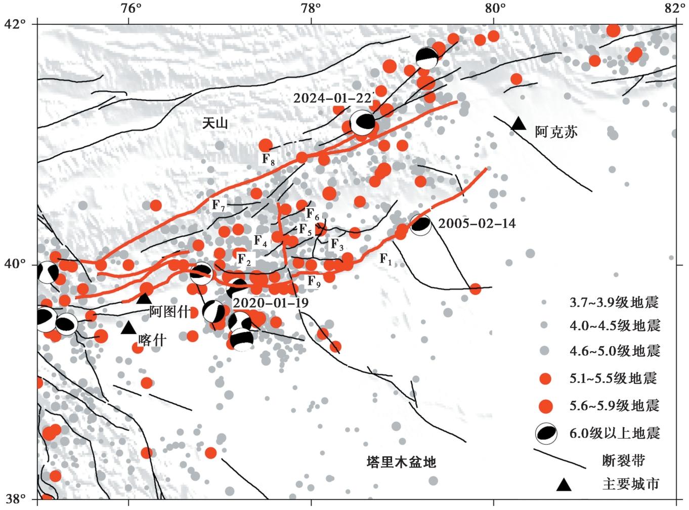
Fig. 1 Tectonic background and historical earthquakes in the study area.
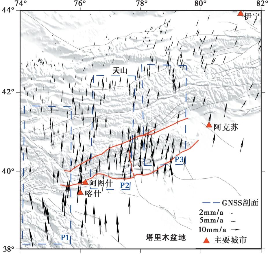
Fig. 2 Results of the fused velocity field.
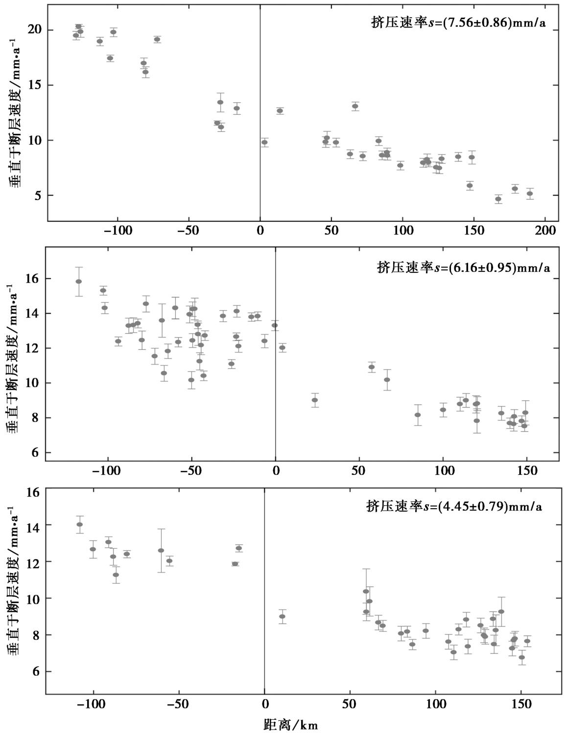
Fig. 3 GNSS results along the profiles.
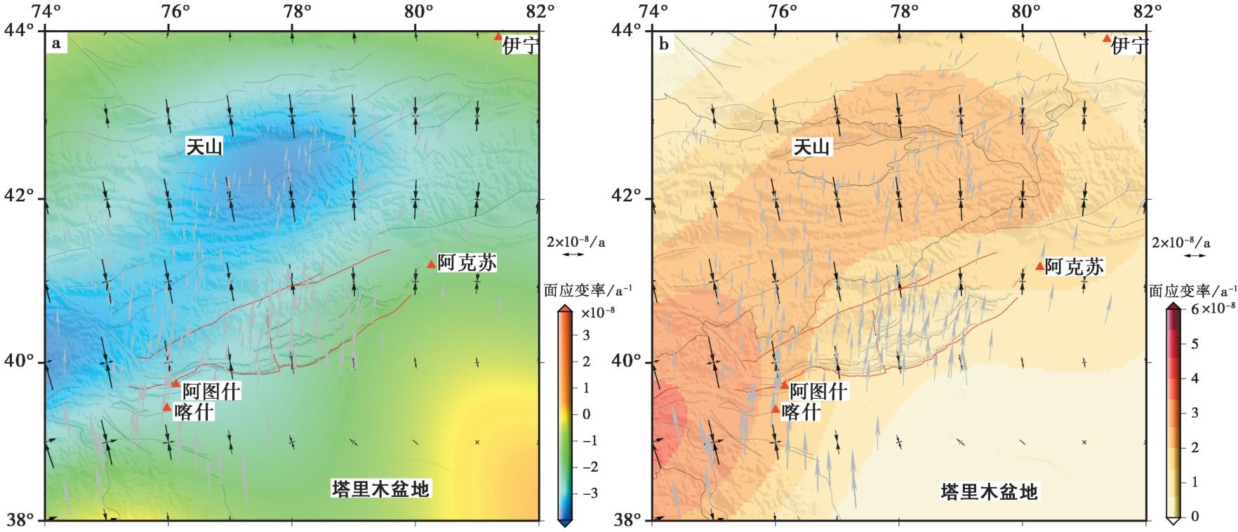
Fig. 4 Distribution of the area strain rate and maximum shear strain rate in the Keping thrust belt.
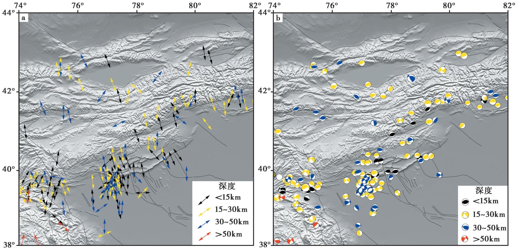
Fig. 5 The principal compressive stress at different depths.
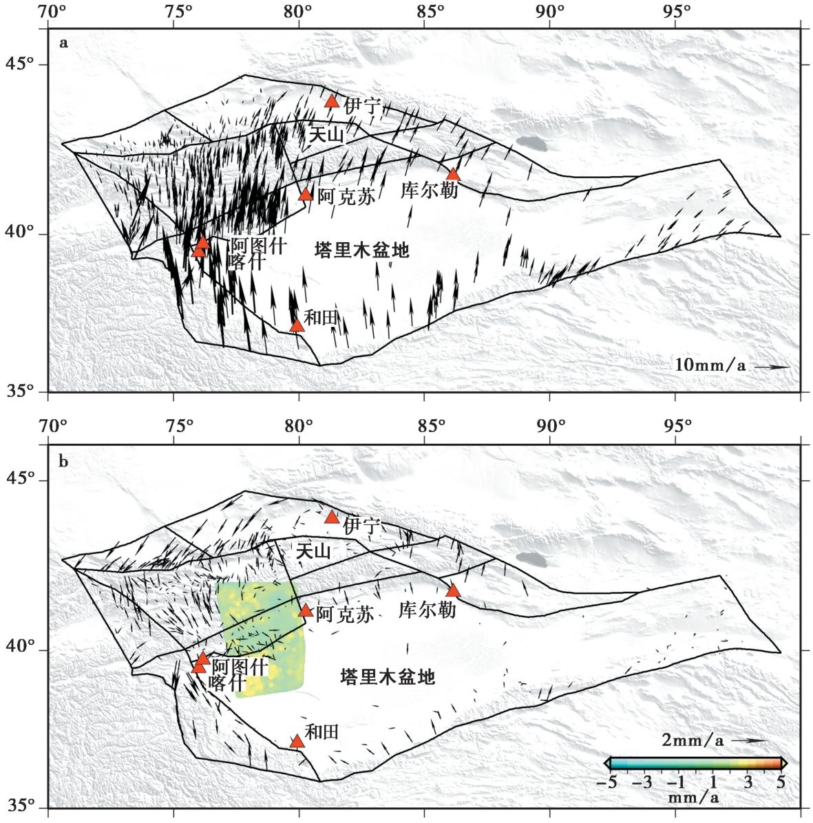
Fig. 6 Distribution of GNSS velocity field and simulation residuals of GNSS and InSAR.
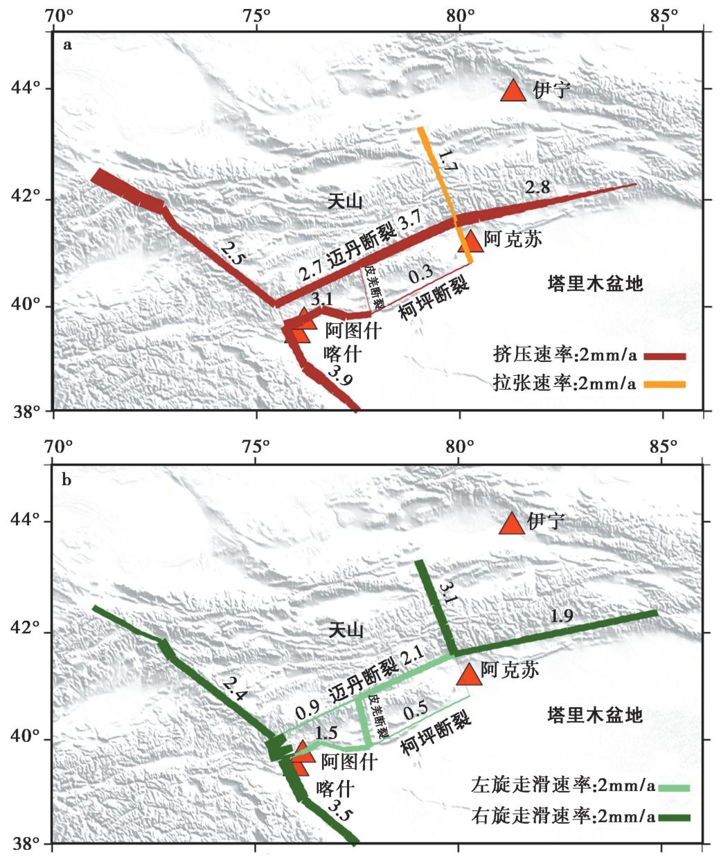
Fig. 7 The slip rates of the main faults in the Keping thrust belt.
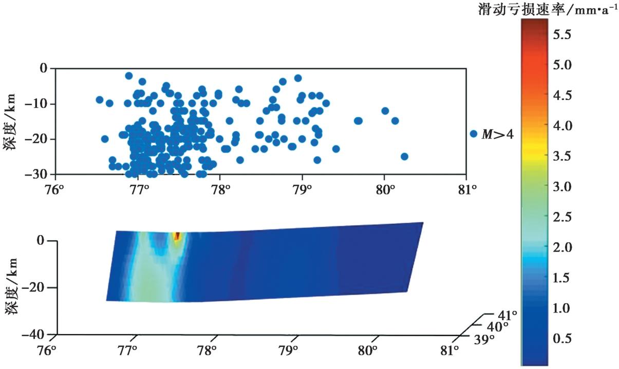
Fig. 8 Distribution of slip deficit rate on the Keping Fault.
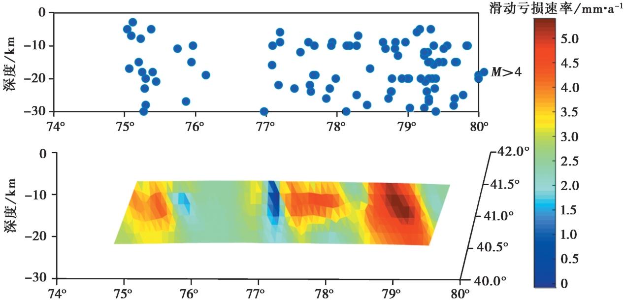
Fig. 9 Distribution of slip deficit rate on the Maidan Fault.
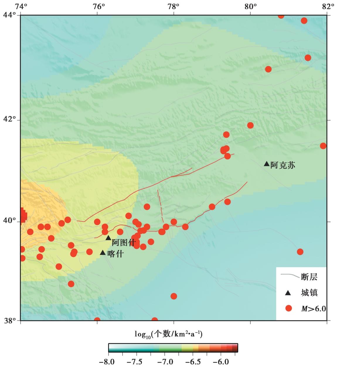
Fig. 10 Prediction results of shallow earthquakes in the southwestern Tianshan region.
| [1] |
邓起东, 冯先岳, 张培震, 等. 2000. 天山活动构造[M]. 北京: 地震出版社.
|
|
|
|
| [2] |
郝明, 朱良玉. 2013. 不同ITRF参考框架NEU坐标系统下的速度场转换[J]. 大地测量与地球动力学, 33(6): 130-132.
|
|
|
|
| [3] |
雷啸宇, 刘兆才, 赵鹏毕, 等. 2023. 2020年1月19日新疆伽师 MS6.4 地震震源及邻区震后构造应力场特征[J]. 内陆地震, 37(1): 99-105.
DOI |
|
DOI |
|
| [4] |
李瑞. 2020. 基于GPS观测的柯坪块体现今地壳形变特征研究[D]. 武汉: 中国地震局地震研究所.
|
|
|
|
| [5] |
李瑞, 李杰, 刘代芹, 等, 2021. 柯坪块体周缘主要断裂闭锁程度与滑动亏损速率的分布特征[J]. 中国地震, 37(4): 868-877.
|
|
|
|
| [6] |
刘代芹,
DOI |
|
|
|
| [7] |
吴传勇. 2016. 西南天山北东东走向断裂的晚第四纪活动特征及在天山构造变形中的作用[D]. 北京: 中国地震局地质研究所.
|
|
|
|
| [8] |
武艳强, 江在森, 朱爽, 等. 2020. 中国大陆西部 GNSS 变形特征及其与M≥7.0强震孕育的关系[J]. 中国地震, 36(4): 756-766.
|
|
|
|
| [9] |
杨少敏, 李杰, 王琪. 2008. GPS研究天山现今变形与断层活动[J]. 中国科学(D 辑), 38(7): 872-880.
|
|
|
|
| [10] |
张培震, 邓起东, 杨晓平, 等. 1996. 天山的晚新生代构造变形及其地球动力学问题[J]. 中国地震, 12(2): 127-140.
|
|
|
|
| [11] |
张培震, 邓起东, 张先康, 等. 2003. 中国大陆的强震活动与活动地块[J]. 中国科学(D 辑), 33(S1): 12-20.
|
|
|
|
| [12] |
周德敏. 2013. 中西天山现今地壳形变特征及地震危险性分析[D]. 北京: 中国地震局地质研究所.
|
|
|
|
| [13] |
朱爽, 梁洪宝, 魏文薪, 等. 2021. 天山地震带主要活动断层现今的滑动速率及其地震矩亏损[J]. 地震地质, 43(1): 249-261. doi: 10.3969/j.issn.0253-4967.2021.01.015.
|
|
DOI |
|
| [14] |
朱爽, 占伟, 刘晓, 等. 2024. 新疆乌什7.1级地震前GNSS变形特征分析[J]. 地震工程学报, 46(4): 973-981.
|
|
|
|
| [15] |
|
| [16] |
|
| [17] |
|
| [18] |
|
| [19] |
|
| [20] |
|
| [21] |
|
| [22] |
|
| [23] |
|
| [24] |
|
| [25] |
|
| [26] |
|
| [27] |
|
| [28] |
|
| [29] |
|
| [30] |
|
| [31] |
|
| [1] | CHANG Yu-qiao, ZHANG Hui-ping, ZHAO Xu-dong. RESEARCH ADVANCES OF THE LATE QUATERNARY ACTIVITY OF XIAOJIANG FAULT ZONE IN THE SOUTHEASTERN MARGIN OF QINGHAI-XIZANG PLATEAU [J]. SEISMOLOGY AND GEOLOGY, 2026, 48(2): 279-313. |
| [2] | XU Wei, LI Guang-tao, CHENG Li, ZOU Zi-nan. LATE QUATERNARY ACTIVITY CHARACTERISTICS IN THE SHIBAN RIVER TO NANNIWAN SEGMENT OF THE SOUTHERN MAOMAOSHAN MARGINAL FAULT [J]. SEISMOLOGY AND GEOLOGY, 2026, 48(2): 386-402. |
| [3] | LUO Jia-xin, LI Bin, LI Zi-hong, FAN Kun. CHARACTERISTICS OF VERTICAL SLIP RATE EVOLUTION ALONG THE JIAOCHENG FAULT ZONE, SHANXI, SINCE LATE PLEISTOCENE [J]. SEISMOLOGY AND GEOLOGY, 2026, 48(1): 43-63. |
| [4] | CHEN Yan-wen, YUAN Dao-yang, YAO Yun-sheng, YU Jin-chao, WEN Ya-meng, SU Rui-huan, SUN Hao. CHARACTERISTICS OF LATE QUATERNARY ACTIVITY AND TECTONIC IMPLICATIONS OF THE MAYAXUESHAN FAULT IN THE EASTERN QILIAN SHAN [J]. SEISMOLOGY AND GEOLOGY, 2025, 47(6): 1566-1585. |
| [5] | CHEN Chang-yun, YIN Hai-quan. CRUSTAL DEFORMATION CHARACTERISTICS AND PROBABILITY PREDICTION OF STRONG EARTHQUAKE RISK IN XINJIANG AND ITS ADJACENT REGION [J]. SEISMOLOGY AND GEOLOGY, 2025, 47(2): 384-404. |
| [6] | YANG Si-yuan, HU Yan. COSEISMIC SLIP AND COULOMB STRESS OF THE 2024 MW7.1 HYUGANADA EARTHQUAKE [J]. SEISMOLOGY AND GEOLOGY, 2025, 47(2): 597-609. |
| [7] | XU Bin-bin, ZHANG Yi-peng, LU Le-jun, TIAN Qing-ying, YANG Xue, WANG Yang, ZHANG Pei-zhen. STUDY ON SEISMOGENIC TECTONICS OF THE 2025 MYANMAR MS7.9 EARTHQUAKE [J]. SEISMOLOGY AND GEOLOGY, 2025, 47(2): 649-670. |
| [8] | HUA Chun-yu, SHI Feng, WEI Zhan-yu. STUDY ON THE SLIP RATE OF THE BAISHA RIVER SEGMENT IN THE YINGXIU-BEICHUAN FAULT IN THE LONGMENSHAN FAULT ZONE [J]. SEISMOLOGY AND GEOLOGY, 2024, 46(6): 1295-1313. |
| [9] | HUANG Wei-liang, ZHANG Jia-le, XIANG Wen, YANG Qian-hao. THE LATE QUATERNARY ACTIVITY CHARACTERISTICS AND SLIP RATE OF BATANG FAULT IN SE TIBETAN PLATEAU [J]. SEISMOLOGY AND GEOLOGY, 2023, 45(6): 1265-1285. |
| [10] | CHEN Yi, ZHAO Bin, XIONG Wei, WANG Wei, YU Peng-fei, YU Jian-sheng, WANG Dong-zhen, CHEN Wei, QIAO Xue-jun. INTERSEISMIC SLIP RATES AND SHALLOW CREEP ALONG THE NORTHWESTERN SEGMENT OF THE XIANSHUIHE FAULT FROM INSAR DATA [J]. SEISMOLOGY AND GEOLOGY, 2023, 45(5): 1074-1091. |
| [11] | ZHU Zhi-guo, ZHU Yi-qing, WANG Dong-zhen, HUSAN Irxat. COMPREHENSIVE ANALYSIS OF GRAVITY AND CRUSTAL DEFORMATION OF JIASHI MS6.4 EARTHQUAKE IN 2020 [J]. SEISMOLOGY AND GEOLOGY, 2023, 45(1): 269-285. |
| [12] | YUAN Hao-dong, LI An, HUANG Wei-liang, HU Zong-kai, ZUO Yu-qi, YANG Xiao-ping. GEOLOGICAL DEFORMATION OF THE TUOLI FAULT IN THE WEST JUNGGAR SINCE THE LATE QUATERNARY [J]. SEISMOLOGY AND GEOLOGY, 2023, 45(1): 49-66. |
| [13] | YANG Yuan-yuan, LI Peng-fei, LU Shuo, SHU Peng, PAN Hao-bo, FANG Liang-hao, ZHENG Hai-gang, ZHAO Peng, ZHENG Ying-ping, YAO Da-quan. PALEOEARTHQUAKES AND VERTICAL SLIP RATES ON THE HUAI RIVER-NÜSHAN LAKE SEGMENT OF FAULT F5 IN THE MIDDLE SECTION OF THE TANLU FAULT ZONE [J]. SEISMOLOGY AND GEOLOGY, 2022, 44(6): 1365-1383. |
| [14] | ZHANG Xiu-li, XIONG Jian-guo, ZHANG Pei-zhen, LIU Qing-ri, YAO Yong, ZHONG Yue-zhi, ZHANG Hui-ping, LI You-li. STUDY ON THE SLIP RATE OF THE NORTH ZHONGTIAO SHAN FAULT SINCE THE LATE MIDDLE PLEISTOCENE [J]. SEISMOLOGY AND GEOLOGY, 2022, 44(6): 1403-1420. |
| [15] | SHAO Yan-xiu, LIU-ZENG Jing, GAO Yun-peng, WANG Wen-xin, YAO Wen-qian, HAN Long-fei, LIU Zhi-jun, ZOU Xiao-bo, WANG Yan, LI Yun-shuai, LIU Lu. COSEISMIC DISPLACEMENT MEASUREMENT AND DISTRIBUTED DEFORMATION CHARACTERIZATION: A CASE OF 2021 MW7.4 MADOI EARTHQUAKE [J]. SEISMOLOGY AND GEOLOGY, 2022, 44(2): 506-523. |
| Viewed | ||||||
|
Full text |
|
|||||
|
Abstract |
|
|||||
Copyright © SEISMOLOGY AND GEOLOGY, All Rights Reserved.
Tel: 010-62009049/9063 E-mail: dzdz@ies.ac.cn
Powered by Beijing Magtech Co., Ltd.