
SEISMOLOGY AND GEOLOGY ›› 2023, Vol. 45 ›› Issue (1): 92-110.DOI: 10.3969/j.issn.0253-4967.2023.01.005
Previous Articles Next Articles
TYPICAL REMOTE SENSING IMAGES OF HOLOCENE FAULTS IN GAIZE PAN(I45)IN TIBET
BAI Qilegeer1),3)( ), SHEN Jun1),2),*(), XIAO Chun1), DAI Xun-ye1),2)
- 1)Key Laboratory of seismic Dynamics of Hebei Province, Sanhe, Hebei 650201, China
2)Institute of Disaster Prevention, Sanhe, Hebei 650201, China
3)Earthquake Agencyof Inner Mongolia Autonomous Region, Hohhot, Inner Mongolia 010010, China
-
Received:2022-05-04Revised:2022-06-28Online:2023-02-20Published:2023-03-24
西藏中北部改则幅(I45)全新世断层典型遥感影像
白其乐格尔1),3)(), 沈军1),2),*(), 肖淳1), 戴训也1),2)
- 1)防灾科技学院, 三河 650201
2)河北省地震动力学重点实验室, 三河 650201
3)内蒙古自治区地震局, 呼和浩特 010010
-
通讯作者:* 沈军, 男, 1966年生, 博士, 研究员, 主要从事地震地质和综合减灾研究, E-mail: shenjuneq@qq.com。 -
作者简介:白其乐格尔, 女, 1992年生, 现为防灾科技学院资源与环境专业在读硕士研究生, 助理工程师, 主要从事地震地质研究, E-mail: 2068866421@qq.com。 -
基金资助:第1次全国自然灾害风险普查项目(地震灾害)全国 1︰100万地震构造图编制(西藏区域)分项资助
CLC Number:
Cite this article
BAI Qilegeer, SHEN Jun, XIAO Chun, DAI Xun-ye. TYPICAL REMOTE SENSING IMAGES OF HOLOCENE FAULTS IN GAIZE PAN(I45)IN TIBET[J]. SEISMOLOGY AND GEOLOGY, 2023, 45(1): 92-110.
白其乐格尔, 沈军, 肖淳, 戴训也. 西藏中北部改则幅(I45)全新世断层典型遥感影像[J]. 地震地质, 2023, 45(1): 92-110.
share this article
Add to citation manager EndNote|Ris|BibTeX
URL: https://www.dzdz.ac.cn/EN/10.3969/j.issn.0253-4967.2023.01.005

Fig. 1 Distribution map of active faults in Gaize unit(I45)of Tibet region.
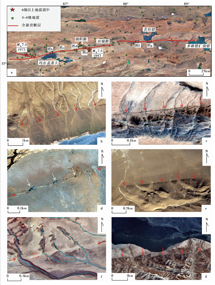
Fig. 2 MargaiCaka fault and its typical images.
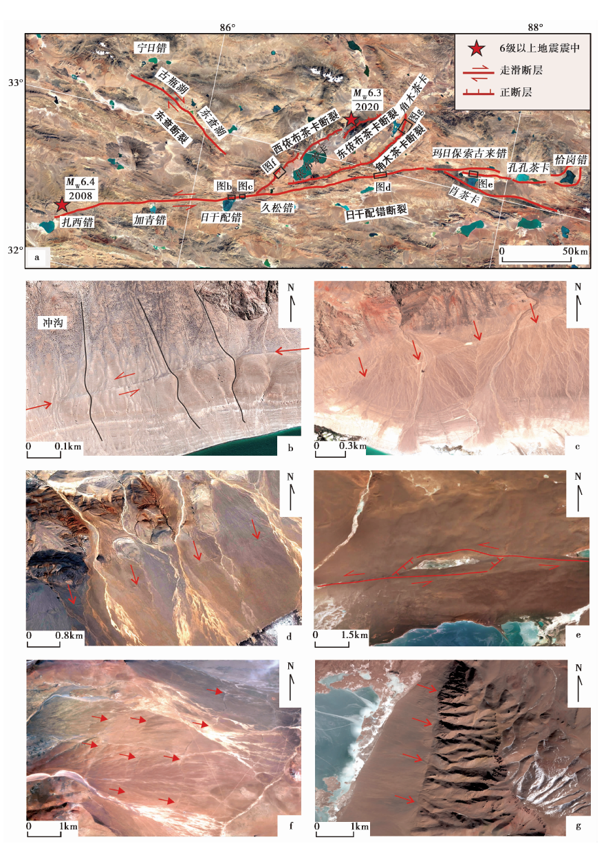
Fig. 3 RiganPeico fault and YibuCaka graben and their typical images.
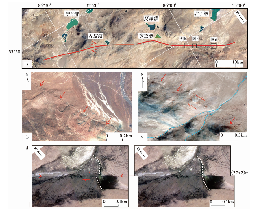
Fig. 4 Dongcha fault and its typical images.
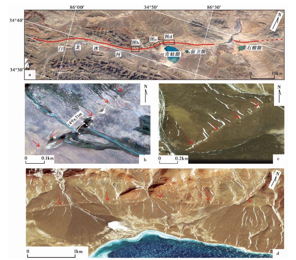
Fig. 5 Qingwahu fault and its typical images.
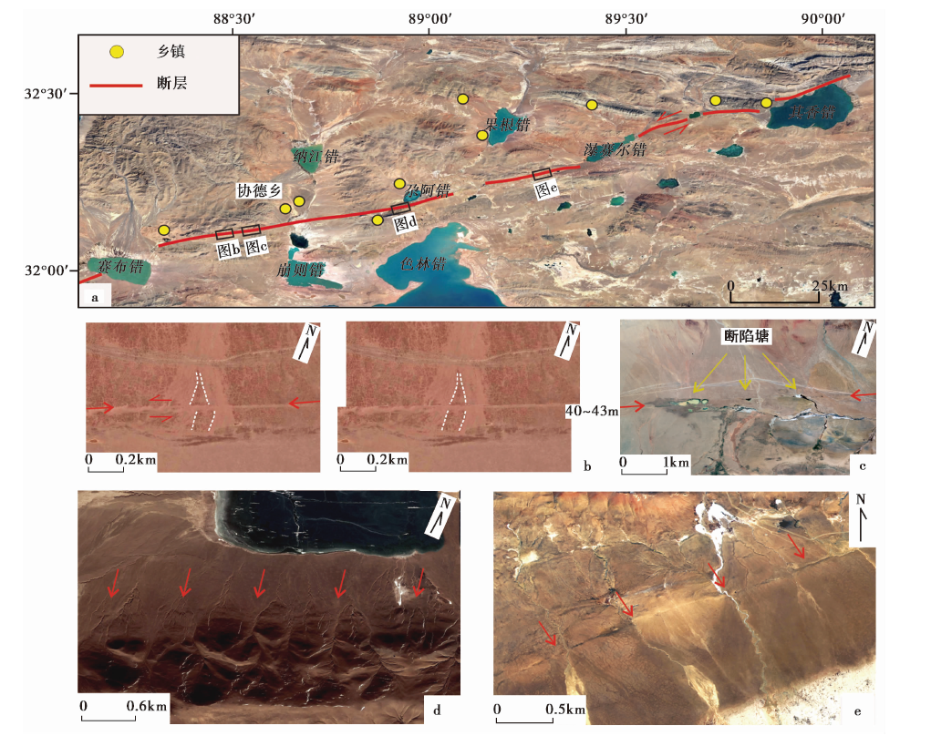
Fig. 6 Qixiangcuo fault and its typical images in the study area.
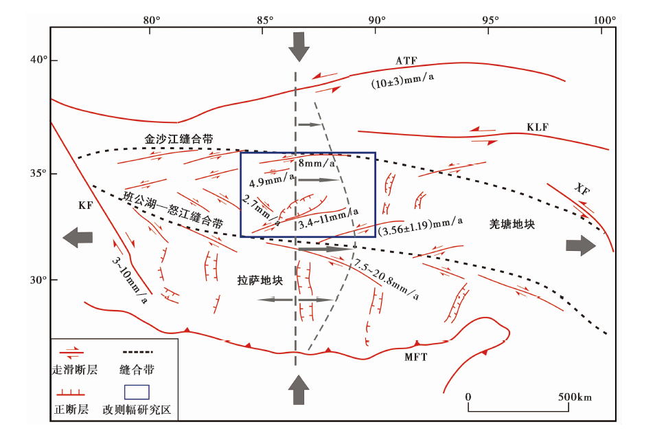
Fig. 7 Sketch map of the Qinghai-Tibetan plateau tectonic style.
| [1] | 邓起东, 闻学泽. 2008. 活动构造研究: 历史、 进展与建议[J]. 地震地质, 30(1): 130. |
| DENG Qi-dong, WEN Xue-ze. 2008. A review on the research of active tectonics: History, progress and suggestions[J]. Seismology and Geology, 30(1): 130. (in Chinese) | |
| [2] | 付碧宏, 时丕龙, 张之武. 2008. 四川汶川 MS8.0 大地震地表破裂带的遥感影像解析[J]. 地质学报, 82(12): 16791687. |
| FU Bi-hong, SHI Pi-long, ZHANG Zhi-wu. 2008. Spatial characteristics of the surface rupture produced by the MS8.0 Wenchuan earthquake using high-resolution remote sensing imagery[J]. Acta Geologica Sinica, 82(12): 16791687. (in Chinese) | |
| [3] | 付碧宏, 张松林, 谢小平, 等. 2006. 阿尔金断裂系西段康西瓦断裂的晚第四纪构造地貌特征研究[J]. 第四纪研究, 26(2): 228235. |
| FU Bi-hong, ZHANG Song-lin, XIE Xiao-ping, et al. 2006. Late Quaternary tectonic-geomorphic features along the Kangxiwar fault, Altyn Tagh fault system, northern Tibet[J]. Quaternary Sciences, 26(2): 228235. (in Chinese) | |
| [4] | 高翔, 邓起东. 2013. 巴颜喀喇断块边界断裂强震活动分析[J]. 地质学报, 87(1): 919. |
| GAO Xiang, DENG Qi-dong. 2013. Analysis of large earthquake in boundary faults around Bayankala fault-block[J]. Acta Geologica Sinica, 87(1): 919. (in Chinese) | |
| [5] | 冀宗童, 张永志, 王思佳. 2021. 2020年西藏尼玛 MS6.6 地震InSAR同震形变场及断层滑动分布反演[J]. 地球物理学进展, 36(6): 23122319. |
| JI Zong-tong, ZHANG Yong-zhi, WANG Si-jia. 2021. Coseismic deformation field and fault slip distribution inversion of the MS6.6 Nima, Xizang earthquake by Sentinel-1A InSAR data[J]. Progress in Geophysics, 36(6): 23122319. (in Chinese) | |
| [6] | 李承涛, 李琦, 谭凯, 等. 2021. 2020年西藏尼玛 MW6.3 地震InSAR同震形变特征与破裂滑动分布[J]. 地球物理学报, 64(7): 22972310. |
| LI Cheng-tao, LI Qi, TAN Kai, et al. 2021. Coseismic deformation characteristics of the 2020 Nima, Xizang MW6.3 earthquake from Sentinel-1A/B InSAR data and rupture slip distribution[J]. Chinese Journal of Geophysics, 64(7): 22972310. (in Chinese) | |
| [7] | 李建华. 1998. 利用卫星图像研究西藏羌塘及邻区的断裂活动性[J]. 地震地质, 20(3): 201207. |
| LI Jian-hua. 1998. A study on fault activity of Qiangtang and its neighboring areas in Xizang(Tibet)by using Landsat images[J]. Seismology and Geology, 20(3): 201207. (in Chinese) | |
| [8] | 李康, 王躲, 邵庆丰, 等. 2018. 青藏高原中部NE向其香错断裂全新世左旋走滑速率及其构造意义[J]. 地震地质, 40(6): 12041215. |
| LI Kang, WANG Duo, SHAO Qing-feng, et al. 2018. Holocene slip rate along the NE-trending Qixiang Co fault in the central Tibetan plateau and its tectonic implications[J]. Seismology and Geology, 40(6): 12041215. (in Chinese) | |
| [9] | 梁世川, 瞿伟, 陈海禄, 等. 2022. 2020-07-23西藏尼玛 MW6.3 地震震源参数InSAR反演与发震构造研究[J]. 大地测量与地球动力学, 42(1): 7176. |
| LIANG Shi-chuan, QU Wei, CHEN Hai-lu, et al. 2022. Source parameter inversion and seismogenic tectonics of the Nyima MW6.3 earthquake in Tibet on July 23, 2020 based on InSAR[J]. Journal of Geodesy and Geodynamics, 42(1): 7176. (in Chinese) | |
| [10] | 刘富财, 潘家伟, 李海兵, 等. 2022. 青藏高原中部日干配错断裂第四纪活动特征及2020年7月23日西藏尼玛 MW6.4 地震发震构造分析[J]. 地球学报, 43(2): 173188. |
| LIU Fu-cai, PAN Jia-wei, LI Hai-bing, et al. 2022. Characteristics of Quaternary activities along the Riganpei Co Fault and seismogenic structure of the July 23, 2020 MW6.4 Nima earthquake, Central Tibet[J]. Acta Geoscientia Sinica, 43(2): 173188. (in Chinese) | |
| [11] | 马瑾, 单新建. 2000. 利用遥感技术研究断层现今活动的探索: 以玛尼地震前后断层相互作用为例[J]. 地震地质, 22(3): 210215. |
| MA Jin, SHAN Xin-jian. 2000. An attempt to study fault activity using remote sensing technology: a case of the Mani earthquake[J]. Seismology and Geology, 22(3): 210215. (in Chinese) | |
| [12] | 邱江涛, 季灵运, 刘雷, 等. 2021. 2020年西藏尼玛 MW6.3 地震的InSAR同震形变与构造意义[J]. 地震地质, 43(6): 15861599. |
| QIU Jiang-tao, JI Ling-yun, LIU lei, et al. 2021. InSAR coseismic deformation and tectonic implications for the 2020 MW6.3 Nima earthquake in Xizang[J]. Seismology and Geology, 43(6): 15861599. (in Chinese) | |
| [13] | 单新建, 李建华, 张桂芳. 2006. 1997年玛尼7.9级地震的构造环境和地表破裂带特征[J]. 地球物理学报, 49(3): 831837. |
| SHAN Xin-jian, LI Jian-hua, ZHANG Gui-fang. 2006. The tectonic condition and the feature of surface rupture zone of the Mani earthquake(MS7.9)in 1997[J]. Chinese Journal of Geophysics, 49(3): 831837. (in Chinese) | |
| [14] | 单新建, 马瑾, 王长林, 等. 2002. 利用差分干涉雷达测量技术(D-InSAR)提取同震形变场[J]. 地震学报, 24(4): 413420. |
| SHAN Xin-jian, MA Jin, WANG Chang-lin, et al. 2002. Extracting coseismic deformation of the 1997 Mani earthquake with differential interferometric SAR[J]. Acta Seismologica Sinica, 24(4): 413420. (in Chinese) | |
| [15] | 沈军, 焦轩凯, 戴训也. 2020. 新编地震地质学简明教程[M]. 北京: 地震出版社. |
| SHEN Jun, JIAO Xuan-kai, DAI Xun-ye. 2020. New Concise Course of Seismic Geology[M]. Seismological Press, Beijing. (in Chinese) | |
| [16] | 孙鑫喆. 2016. 玛尼地震与玉树地震发震断层的破裂特征与复发模型[D]. 北京: 中国地震局地质研究所. |
| SUN Xin-zhe. 2016. Rupture characteristics and recurrence model of seismogenic faults in Mani and Yushu earthquakes[D]. Institute of Geology, China Earthquake Administration, Beijing. (in Chinese) | |
| [17] | 王躲. 2018. 青藏高原中部格仁错断裂带构造地貌研究[D]. 北京: 中国地震局地质研究所. |
| WANG Duo. 2018. Tectonic geomorphology along the Gyaring Co Fault in central Tibet[D]. Institute of Geology, China Earthquake Administration, Beijing. (in Chinese) | |
| [18] | 王月, 解孟雨, 姜祥华, 等. 2020. 2020年西藏改则3次5级以上地震总结[J]. 地震地磁观测与研究, 41(3): 174183. |
| WANG Yue, XIE Meng-yu, JIANG Xiang-hua, et al. 2020. About three Gaize MS≥5.0 earthquakes in Xizang during Feb. 21 to Mar. 12, 2020[J]. Seismological and Geomagnetic Observation and Research, 41(3): 174183. (in Chinese) | |
| [19] | 谢小平, 白毛伟, 陈芝聪, 等. 2019. 龙门山断裂带北东段活动断裂的遥感影像解译及构造活动性分析[J]. 国土资源遥感, 31(1): 237246. |
| XIE Xiao-ping, BAI Mao-wei, CHEN Zhi-cong, et al. 2019. Remote sensing image interpretation and tectonic activity study of the active faults along the northeastern segment of the Longmenshan fault[J]. Remote Sensing for Land & Resources, 31(1): 237246. (in Chinese) | |
| [20] | 徐锡伟. 2000. 藏北玛尼地震科学考察[M]. 北京: 地震出版社. |
| XU Xi-wei. 2000. A Scientific Investigation of the Mani Earthquake in Northern Tibet[M]. Seismological Press, Beijing. (in Chinese) | |
| [21] | 张世富. 2013. 基于Google Earth的高分辨率影像获取方法探讨[J]. 电子技术, 42(12): 1618. |
| ZHANG Shi-fu. 2013. Discussion on high-resolution image acquisition method based on Google Earth[J]. Electronic Technology, 42(12): 1618. (in Chinese) | |
| [22] | 张乙, 王俊, 陈寒万平, 等. 2019. 91卫图助手在建筑结构震害预测工作中的应用[J]. 山西建筑, 45(20): 197198. |
| ZHANG Yi, WANG Jun, CHEN Han-wanping, et al. 2019. Application of 91 satellite maps in earthquake damage prediction of building structure[J]. Shanxi Architecture, 45(20): 197198. (in Chinese) | |
| [23] | 中华人民共和国国家质量监督检验检疫总局, 中国国家标准化管理委员会. 2018. 中华人民共和国国家标准: 活动断层探测[S]. 北京: 中国标准出版社. |
| General Administration of Quality Supervision, Inspection and Quarantine of the People’s Republic of China, Standardization Administration of China. 2018. National Standard of the People’s Republic of China: Active Fault Detection[S]. China Standard Press, Beijing. (in Chinese) | |
| [24] | Chen Q, Freymueller J T, Wang Q, et al. 2004. A deforming block model for the present-day tectonics of Tibet[J]. Journal of Geophysical Research: Solid Earth, 109(B1): B01403. |
| [25] |
Elliott J R, Walters R J, England P C, et al. 2010. Extension on the Tibetan plateau: Recent normal faulting measured by InSAR and body wave seismology[J]. Geophysical Journal International, 183(2): 503535.
DOI URL |
| [26] |
Han S, Li H B, Pan J W, et al. 2019. Co-seismic surface ruptures in Qiangtang Terrane: Insight into Late Cenozoic deformation of central Tibet[J]. Tectonophysics, 750: 359378.
DOI URL |
| [27] | Li H, Chevalier M L, Tapponnier P, et al. 2021. Block tectonics across Western Tibet and multi-millennial recurrence of great earthquakes on the Karakax Fault[J]. Journal of Geophysical Research: Solid Earth, 126(12): e2021JB022033. |
| [28] |
Li Y, Tian Y, Yu C, et al. 2020. Present-day interseismic deformation characteristics of the Beng Co-Dongqiao conjugate fault system in central Tibet: implications from InSAR observations[J]. Geophysical Journal International, 221(1): 492503.
DOI URL |
| [29] |
Molnar P, Lyon-Caent H. 1989. Fault plane solutions of earthquakes and active tectonics of the Tibetan plateau and its margins[J]. Geophysical Journal International, 99(1): 123153.
DOI URL |
| [30] |
Ratschbacher L, Krumrei I, Blumenwitz M, et al. 2011. Rifting and strike-slip shear in central Tibet and the geometry, age and kinematics of upper crustal extension in Tibet[J]. Geological Society, London, Special Publications, 353(1): 127163.
DOI URL |
| [31] |
Ren Z K, Zhang Z Q. 2019. Structural analysis of the 1997 MW7.5 Manyi earthquake and the kinematics of the Manyi fault, central Tibetan plateau[J]. Journal of Asian Earth Sciences, 179: 149164.
DOI URL |
| [32] |
Rothery D A, Drury S A. 1984. The neotectonics of the Tibetan plateau[J]. Tectonics, 3(1): 1926.
DOI URL |
| [33] | Taylor M, Peltzer G. 2006. Current slip rates on conjugate strike-slip faults in central Tibet using synthetic aperture radar interferometry[J]. Journal of Geophysical Research: Solid Earth, 111(B12): B12402. |
| [34] |
Taylor M, Yin A. 2009. Active structures of the Himalayan-Tibetan orogen and their relationships to earthquake distribution, contemporary strain field, and Cenozoic volcanism[J]. Geosphere, 5(3): 199214.
DOI URL |
| [35] | Taylor M, Yin A, Ryerson F J, et al. 2003. Conjugate strike-slip faulting along the Bangong-Nujiang suture zone accommodates coeval east-west extension and north-south shortening in the interior of the Tibetan plateau[J]. Tectonics, 22(4): 567591. |
| [36] | Velasco A A, Ammon C J, Beck S L. 2000. Broadband source modeling of the November 8, 1997, Tibet(MW=7.5)earthquake and its tectonic implications[J]. Journal of Geophysical Research: Solid Earth, 105(B12): 2806528080. |
| [37] | Wang H, Xu C, Ge L. 2007. Coseismic deformation and slip distribution of the 1997 MW7.5 Manyi, Tibet, earthquake from InSAR measurements[J]. Journal of Geodynamics, 44(3-5): 200212. |
| [38] | Yin A. 2000. Mode of Cenozoic east-west extension in Tibet suggesting a common origin of rifts in Asia during the Indo-Asian collision[J]. Journal of Geophysical Research: Solid Earth, 105(B9): 2174521759. |
| [39] |
Yin A, Kapp P A, Murphy M A, et al. 1999. Significant late Neogene east-west extension in northern Tibet[J]. Geology, 27(9): 787790.
DOI URL |
| [40] | Yin A, Taylor M H. 2011. Mechanics of V-shaped conjugate strike-slip faults and the corresponding continuum mode of continental deformation[J]. Geological Society of America Bulletin, 123(9-10): 17981821. |
| [41] | Zuza A V, Yin A. 2016. Continental deformation accommodated by non-rigid passive bookshelf faulting: An example from the Cenozoic tectonic development of northern Tibet[J]. Tectonophysics, 677-678: 227240. |
| [1] | YANG Chen-yi, LI Xiao-ni, FENG Xi-jie, HUANG Yin-di, PEI Gen-di. SHALLOW STRUCTURE AND QUATERNARY ACTIVITY OF THE TAOCHUAN-HUXIAN FAULT, THE SUB-STRAND OF THE NORTHERN QINLING FAULT ZONE [J]. SEISMOLOGY AND GEOLOGY, 2023, 45(2): 464-483. |
| [2] | LI Yi-shi. RESEARCH ON COMPREHENSIVE STANDARDIZATION FOR SURVEYING AND PROSPECTING OF ACTIVE FAULT [J]. SEISMOLOGY AND GEOLOGY, 2023, 45(2): 455-463. |
| [3] | ZHANG Ling, MIAO Shu-qing, YANG Xiao-ping. THE ANALYSIS AND IMPLEMENTATION OF THE AUTOMATIC EXTRACTING METHOD FOR ACTIVE THRUST FAULTS IN THE NORTH TIANSHAN MOUNTAINS BASED ON ARCGIS SOFTWARE PLATFORM [J]. SEISMOLOGY AND GEOLOGY, 2023, 45(2): 422-434. |
| [4] | JIANG Feng-yun, JI Ling-yun, ZHU Liang-yu, LIU Chuan-jin. THE PRESENT CRUSTAL DEFORMATION CHARACTERISTICS OF THE HAIYUAN-LIUPANSHAN FAULT ZONE FROM INSAR AND GPS OBSERVATIONS [J]. SEISMOLOGY AND GEOLOGY, 2023, 45(2): 377-400. |
| [5] | WANG Liao, XIE Hong, YUAN Dao-yang, LI Zhi-min, XUE Shan-yu, SU Rui-huan, WEN Ya-meng, SU Qi. THE SURFACE RUPTURE CHARACTERISTICS BASED ON THE GF-7 IMAGES INTERPRETATION AND THE FIELD INVESTIGA-TION OF THE 2022 MENYUAN MS6.9 EARTHQUAKE [J]. SEISMOLOGY AND GEOLOGY, 2023, 45(2): 401-421. |
| [6] | LIU Qing, LIU Shao, ZHANG Shi-min. PALEOSEISMOLOGIC STUDY ON THE YUEXI FAULT IN THE MIDSECTION OF THE DALIANGSHAN FAULT ZONE SINCE THE LATE QUATERNARY [J]. SEISMOLOGY AND GEOLOGY, 2023, 45(2): 321-337. |
| [7] | ZHAO Peng, LI Jun-hui, TAO Yue-chao, SHU Peng, FANG Zhen. NEW ACTIVITY PHENOMENA REVEALED BY TRENCH ON THE NORTH SIDE OF NÜSHAN LAKE IN THE TANLU FAULT ZONE AND DISCUSSION [J]. SEISMOLOGY AND GEOLOGY, 2023, 45(2): 338-354. |
| [8] | ZUO Yu-qi, YANG Hai-bo, YANG Xiao-ping, ZHAN Yan, LI An, SUN Xiang-yu, HU Zong-kai. EVIDENCE OF LATE QUATERNARY TECTONIC ACTIVITY OF THE BEIDA SHAN FAULT, SOUTHERN MARGIN OF THE ALASHAN BLOCK [J]. SEISMOLOGY AND GEOLOGY, 2023, 45(2): 355-376. |
| [9] | LI Xiao-ni, YANG Chen-yi, LI Gao-yang, FENG Xi-jie, HUANG Yin-di, LI Chen-xia, LI Miao, PEI Gen-di, WANG Wan-he. SHALLOW STRUCTURE AND LATE QUATERNARY ACTIVITIES OF BRANCH FAULTS ON THE NORTHERN SIDE OF THE WEINAN TABLELAND IN THE SOUTHEASTERN MARGIN OF THE WEIHE BASIN [J]. SEISMOLOGY AND GEOLOGY, 2023, 45(2): 484-499. |
| [10] | LIU Bai-yun, ZHAO Li, LIU Yun-yun, WANG Wen-cai, ZHANG Wei-dong. THE RESEARCH ON RELOCATION AND FAULT PLANE SOLUTION AND GEOMETRIC MEANING OF THE MADUO M7.4 EARTHQUAKE ON 22 MAY 2021 [J]. SEISMOLOGY AND GEOLOGY, 2023, 45(2): 500-516. |
| [11] | ZHAO De-zheng, QU Chun-yan, ZHANG Gui-fang, GONG Wen-yu, SHAN Xin-jian, ZHU Chuan-hua, ZHANG Guo-hong, SONG Xiao-gang. APPLICATIONS AND ADVANCES FOR THE COSEISMIC DEFORMA-TION OBSERVATIONS, EARTHQUAKE EMERGENCY RESPONSE AND SEISMOGENIC STRUCTURE INVESTIGATION USING INSAR [J]. SEISMOLOGY AND GEOLOGY, 2023, 45(2): 570-592. |
| [12] | LI An, WAN Bo, WANG Xiao-xian, JI Hao-min, SUO Rui. NEW EVIDENCE OF THE PALEOEARTHQUAKE RUPTURE IN THE NORTH GAIZHOU-ANSHAN SEGMENT OF THE JINZHOU FAULT [J]. SEISMOLOGY AND GEOLOGY, 2023, 45(1): 111-126. |
| [13] | ZHENG Hai-gang, YAO Da-quan, ZHAO Peng, YANG Yuan-yuan, HUANG Jin-shui. NEW ACTIVITY CHARACTERISTICS IN THE CHISHAN SECTION OF TAN-LU FAULT ZONE IN HOLOCENE [J]. SEISMOLOGY AND GEOLOGY, 2023, 45(1): 127-138. |
| [14] | TIAN Yi-ming, YANG Zhuo-xin, WANG Zhi-shuo, SHI Jin-hu, ZHANG Yang, TAN Ya-li, ZHANG Jian-zhi, SONG Wei, JI Tong-yu. A PRELIMINARY STUDY OF THE SHALLOW EXPLORATION AND QUATERNARY ACTIVITIES OF THE FENGQIU SEGMENT OF THE XINXIANG-SHANGQIU FAULT [J]. SEISMOLOGY AND GEOLOGY, 2023, 45(1): 139-152. |
| [15] | YANG Jian-wen, JIN Ming-pei, CHA Wen-jian, ZHANG Tian-ji, YE Beng. CRUSTAL S-WAVE VELOCITY STRUCTURE BENEATH THE XIAO-JIANG FAULT ZONE AND ADJACENT REGIONS REVEALED BY TWO-STEP INVERSION METHOD OF RECEIVER FUNCTIONS [J]. SEISMOLOGY AND GEOLOGY, 2023, 45(1): 190-207. |
| Viewed | ||||||
|
Full text |
|
|||||
|
Abstract |
|
|||||
Copyright © SEISMOLOGY AND GEOLOGY, All Rights Reserved.
Tel: 010-62009049/9063 E-mail: dzdz@ies.ac.cn
Powered by Beijing Magtech Co., Ltd.