地震地质 ›› 2020, Vol. 42 ›› Issue (1): 50-64.DOI: 10.3969/j.issn.0253-4967.2020.01.004
郑颖平1)( ), 杨晓平2), 疏鹏1,2), 路硕1), 方良好1), 石金虎3), 黄雄南2), 刘春茹2)
收稿日期:2018-08-31
出版日期:2020-02-20
发布日期:2020-02-20
作者简介:〔作者简介〕 郑颖平, 女, 1980年生, 2006年于安徽理工大学获地质工程专业硕士学位,高级工程师, 主要从事活断层探测、 地震安全性评价和地震地质等相关工作, E-mail: ypzheng2006@163.com。
基金资助:
ZHENG Ying-ping1)(), YANG Xiao-ping2), SHU Peng1,2), LU Shuo1), FANG Liang-hao1), SHI Jin-hu3), HUANG Xiong-nan2), LIU Chun-ru2)
Received:2018-08-31
Online:2020-02-20
Published:2020-02-20
摘要:
前人对于郯庐断裂带安徽段出露部分的活动性开展了不同程度的研究, 并获得了丰富的成果, 而对于隐伏于合肥盆地中的段, 其活动性如何, 甚至断裂是否存在一直未能取得明确认识。 文中利用浅层地震勘探及钻探联合地质剖面探测方法, 对隐伏于合肥盆地中的郯庐断裂带西分支断层——乌云山-合肥断裂开展了详细的探测研究工作, 在合肥城区由北向南跨断裂布设了4条浅层地震勘探测线和2排联合钻孔剖面, 采用14C、 OSL和ESR 3种测年手段共获得了34个钻孔地层剖面样品的年龄数据, 结果显示乌云山-合肥断裂错动的最新地层为中更新统青灰色黏土层, 断层活动表现为逆断性质, 最大垂直错距达2.4m, 最新活动时代为中更新世晚期, 上断点最浅埋深达17m。 文中研究证实了郯庐断裂带穿切合肥盆地, 且第四纪以来仍有活动, 所得成果充实了对郯庐断裂带安徽段总体活动的认识。
中图分类号:
郑颖平, 杨晓平, 疏鹏, 路硕, 方良好, 石金虎, 黄雄南, 刘春茹. 合肥盆地中郯庐断裂带西支乌云山-合肥断裂最新活动特征[J]. 地震地质, 2020, 42(1): 50-64.
ZHENG Ying-ping, YANG Xiao-ping, SHU Peng, LU Shuo, FANG Liang-hao, SHI Jin-hu, HUANG Xiong-nan, LIU Chun-ru. STUDY ON THE LATEST ACTIVITY OF WUYUNSHAN-HEFEI FAULT IN HEFEI BASIN, THE WESTERN BRANCH OF THE TANLU FAULT ZONE[J]. SEISMOLOGY AND GEOLOGY, 2020, 42(1): 50-64.
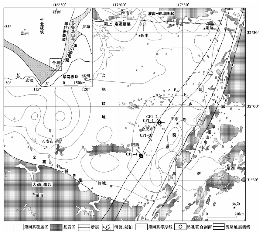
图 1 郯庐断裂带分支断层在合肥盆地中的展布略图F1藕塘-清水涧断裂; F2池河-西山驿断裂; F3桑涧子-广寒桥断裂; F4乌云山-合肥断裂
Fig. 1 The distribution of the subsidiary faults of Tanlu fault zone in Hefei Basin.
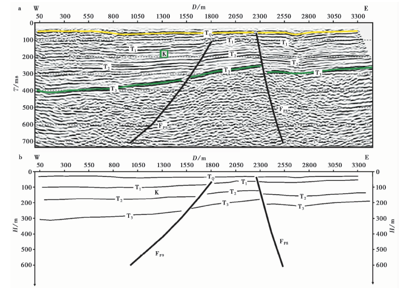
图 2 CF1-2测线的反射波时间剖面(a)和深度剖面(b)
Fig. 2 The time-section(a) and depth-section(b) of reflection waves of line CF1-2.
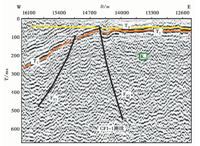
图 3 CF1-1测线的反射波时间剖面
Fig. 3 The time-section of reflection waves of line CF1-1.
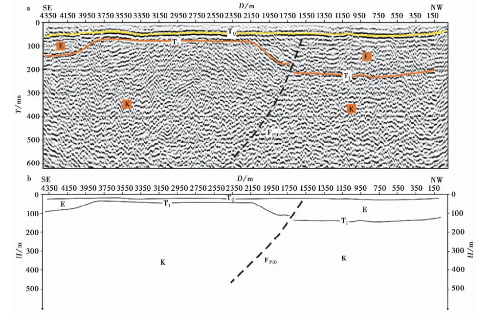
图 4 CF1-3测线的反射波时间剖面(a)和深度剖面(b)
Fig. 4 The time-section(a) and depth-section(b) of reflection waves of line CF1-3.
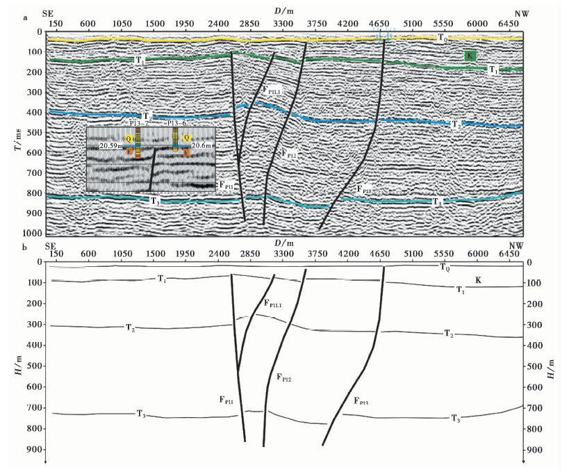
图 5 CF1-4测线的反射波时间剖面(a)和深度剖面(b)
Fig. 5 The time-section(a) and depth-section(b) of reflection waves of line CF1-4.
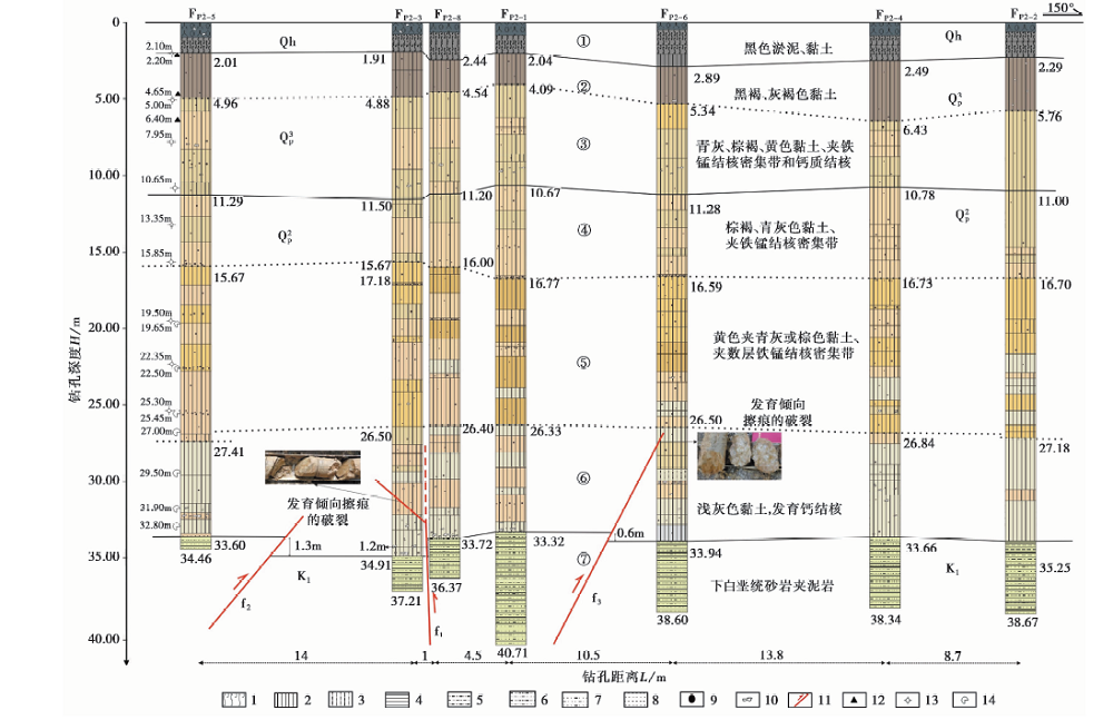
图 6 瑶海公园南门钻孔联合地质剖面1 淤泥; 2 黏土; 3 粉砂质黏土; 4 泥岩; 5 粉砂质泥岩; 6 泥质粉砂岩; 7 泥质细砂岩; 8 粉砂岩; 9 铁锰结核;10 钙质结核; 11 断层; 12 14C样品; 13 光释光样品; 14 电子自旋共振测年样品
Fig. 6 The composite drilling geological section at south gate of Yaohai Park.
| 名称 | 样品编号 | 样品岩性 | 取样深度/m | 测年方法 | 年龄/a | 校正年龄/a |
|---|---|---|---|---|---|---|
| FP2 | FP2-52.20 | 黏土 | 2.20 | 14C | 14 315±40 | 17 441±90 |
| 联合 | FP2-54.65 | 黏土 | 4.65 | 14C | 28 590±120 | 32 631±265 |
| 剖面 | FP2-56.40 | 黏土 | 6.40 | 14C | 24 290±100 | 28 332±15 |
表1 联合钻孔地层剖面14C测年结果
Table1 14C dating of the strata of the composite drilling section
| 名称 | 样品编号 | 样品岩性 | 取样深度/m | 测年方法 | 年龄/a | 校正年龄/a |
|---|---|---|---|---|---|---|
| FP2 | FP2-52.20 | 黏土 | 2.20 | 14C | 14 315±40 | 17 441±90 |
| 联合 | FP2-54.65 | 黏土 | 4.65 | 14C | 28 590±120 | 32 631±265 |
| 剖面 | FP2-56.40 | 黏土 | 6.40 | 14C | 24 290±100 | 28 332±15 |
| 名称 | 样品编号 | 测年 方法 | 取样深度 /m | U /ug·g | Th /ug·g | K2O /% | 含水量 /% | 古剂量 /Gy | 年剂量 /Gy·ka-1 | 年龄 /ka |
|---|---|---|---|---|---|---|---|---|---|---|
| FP2 联 合 剖 面 | FP2-52.10 | OSL | 2.10 | 2.33 | 13.4 | 1.62 | 17.44 | 69.65±6.46 | 3.56 | 19.58±2.67 |
| FP2-55.00 | OSL | 5.00 | 2.54 | 12.7 | 1.18 | 16.54 | 221.26±22.87 | 3.15 | 70.27±10.11 | |
| FP2-57.95 | OSL | 7.95 | 2.11 | 12.5 | 1.48 | 14.91 | 343.58±32.67 | 3.29 | 104.47±14.42 | |
| FP2-510.65 | OSL | 10.65 | 2.35 | 13.2 | 1.45 | 16.64 | 362.93±8.37 | 3.34 | 108.81±11.81 | |
| FP2-513.35 | OSL | 13.35 | 2.86 | 14.6 | 1.47 | 16.49 | 497.57±44.70 | 3.58 | 138.95±18.68 | |
| FP2-515.85 | OSL | 15.85 | 3.33 | 13.6 | 0.78 | 14.41 | 562.71±105.34 | 3.14 | 179.25±38.04 | |
| FP2-519.50 | OSL | 19.50 | 2.93 | 13.6 | 0.98 | 16.38 | 665.05±52.39 | 3.15 | 211.46±26.92 | |
| FP2-522.35 | OSL | 22.35 | 2.61 | 13.4 | 1.25 | 16.36 | 552.42±72.71 | 3.24 | 170.27±28.15 | |
| FP2-525.30 | OSL | 25.30 | 2.69 | 12.5 | 1.43 | 18.00 | 508.23±35.28 | 3.21 | 158.29±19.27 | |
| FP2-519.65 | ESR | 19.65 | 3.84 | 17.0 | 1.44 | 16.22 | 1 873±164 | 3.08 | 608±53 | |
| FP2-522.50 | ESR | 22.50 | 3.00 | 14.2 | 1.69 | 15.91 | 874±161 | 2.95 | 296±55 | |
| FP2-525.45 | ESR | 25.45 | 3.17 | 14.8 | 1.96 | 17.05 | 1 026±204 | 3.17 | 324±64 | |
| FP2-527.00 | ESR | 27.00 | 2.81 | 14.3 | 1.40 | 16.54 | 4 287±1 238 | 2.67 | 1 606±461 | |
| FP2-529.50 | ESR | 29.50 | 2.71 | 14.4 | 1.33 | 15.49 | 1 074±344 | 2.64 | 407±130 | |
| FP2-531.90 | ESR | 31.90 | 1.66 | 8.9 | 1.28 | 12.46 | 1 331±302 | 2.14 | 622±141 | |
| FP2-532.80 | ESR | 32.80 | 2.01 | 9.84 | 1.12 | 12.14 | 1 301±230 | 2.15 | 605±107 | |
| FP13 联 合 剖 面 | FP13-71.70 | OSL | 1.70 | 3.28 | 13.30 | 1.54 | 13.12 | 0.16 | 57.8±2.81 | |
| FP13-73.50 | OSL | 3.50 | 1.72 | 8.84 | 1.32 | 12.76 | 0.13 | 75.42±5.98 | ||
| FP13-716.65 | OSL | 16.65 | 3.00 | 14.40 | 0.97 | 11.69 | 0.04 | 212.92±11.07 | ||
| FP13-719.15 | OSL | 19.15 | 1.66 | 11.20 | 0.96 | 12.11 | 0.03 | 265.67±19.51 | ||
| FP13-714.00 | ESR | 14.00 | 2.25 | 12.2 | 1.37 | 13.58 | 1 991±424 | 2.50 | 796±170 | |
| FP13-716.80 | ESR | 16.80 | 2.65 | 13.3 | 1.14 | 13.50 | 1 391±175 | 2.47 | 563±71 | |
| FP13-115.05 | OSL | 5.05 | 2.24 | 11.00 | 1.41 | 13.39 | 0.10 | 99.92±9.87 | ||
| FP13-117.45 | OSL | 7.45 | 2.05 | 10.50 | 1.29 | 16.59 | 0.08 | 177.45±12.97 | ||
| FP13-119.45 | OSL | 9.45 | 2.10 | 11.90 | 1.03 | 13.25 | 0.06 | 193.81±15.99 | ||
| FP13-1112.55 | OSL | 12.55 | 1.77 | 9.03 | 1.37 | 12.75 | 0.05 | 237.62±21.39 | ||
| FP13-1115.15 | OSL | 15.15 | 2.53 | 11.70 | 1.25 | 8.86 | 0.04 | 192.12±18.77 | ||
| FP13-1116.15 | OSL | 16.15 | 1.81 | 12.20 | 1.10 | 11.44 | 0.04 | 212.49±21.58 | ||
| FP13-1117.25 | OSL | 17.25 | 1.75 | 9.57 | 1.11 | 9.33 | 0.03 | 253.68±19.61 | ||
| FP13-1119.50 | OSL | 19.50 | 1.56 | 9.42 | 0.91 | 11.02 | 0.03 | 270.35±25.69 | ||
| FP13-1120.50 | OSL | 20.50 | 1.54 | 10.40 | 0.36 | 14.80 | 0.03 | 402.72±57.46 |
表2 联合钻孔地层剖面光释光(OSL)测年及电子自旋共振(ESR)测年结果
Table2 OSL and ESR dating of the strata of the composite drilling section
| 名称 | 样品编号 | 测年 方法 | 取样深度 /m | U /ug·g | Th /ug·g | K2O /% | 含水量 /% | 古剂量 /Gy | 年剂量 /Gy·ka-1 | 年龄 /ka |
|---|---|---|---|---|---|---|---|---|---|---|
| FP2 联 合 剖 面 | FP2-52.10 | OSL | 2.10 | 2.33 | 13.4 | 1.62 | 17.44 | 69.65±6.46 | 3.56 | 19.58±2.67 |
| FP2-55.00 | OSL | 5.00 | 2.54 | 12.7 | 1.18 | 16.54 | 221.26±22.87 | 3.15 | 70.27±10.11 | |
| FP2-57.95 | OSL | 7.95 | 2.11 | 12.5 | 1.48 | 14.91 | 343.58±32.67 | 3.29 | 104.47±14.42 | |
| FP2-510.65 | OSL | 10.65 | 2.35 | 13.2 | 1.45 | 16.64 | 362.93±8.37 | 3.34 | 108.81±11.81 | |
| FP2-513.35 | OSL | 13.35 | 2.86 | 14.6 | 1.47 | 16.49 | 497.57±44.70 | 3.58 | 138.95±18.68 | |
| FP2-515.85 | OSL | 15.85 | 3.33 | 13.6 | 0.78 | 14.41 | 562.71±105.34 | 3.14 | 179.25±38.04 | |
| FP2-519.50 | OSL | 19.50 | 2.93 | 13.6 | 0.98 | 16.38 | 665.05±52.39 | 3.15 | 211.46±26.92 | |
| FP2-522.35 | OSL | 22.35 | 2.61 | 13.4 | 1.25 | 16.36 | 552.42±72.71 | 3.24 | 170.27±28.15 | |
| FP2-525.30 | OSL | 25.30 | 2.69 | 12.5 | 1.43 | 18.00 | 508.23±35.28 | 3.21 | 158.29±19.27 | |
| FP2-519.65 | ESR | 19.65 | 3.84 | 17.0 | 1.44 | 16.22 | 1 873±164 | 3.08 | 608±53 | |
| FP2-522.50 | ESR | 22.50 | 3.00 | 14.2 | 1.69 | 15.91 | 874±161 | 2.95 | 296±55 | |
| FP2-525.45 | ESR | 25.45 | 3.17 | 14.8 | 1.96 | 17.05 | 1 026±204 | 3.17 | 324±64 | |
| FP2-527.00 | ESR | 27.00 | 2.81 | 14.3 | 1.40 | 16.54 | 4 287±1 238 | 2.67 | 1 606±461 | |
| FP2-529.50 | ESR | 29.50 | 2.71 | 14.4 | 1.33 | 15.49 | 1 074±344 | 2.64 | 407±130 | |
| FP2-531.90 | ESR | 31.90 | 1.66 | 8.9 | 1.28 | 12.46 | 1 331±302 | 2.14 | 622±141 | |
| FP2-532.80 | ESR | 32.80 | 2.01 | 9.84 | 1.12 | 12.14 | 1 301±230 | 2.15 | 605±107 | |
| FP13 联 合 剖 面 | FP13-71.70 | OSL | 1.70 | 3.28 | 13.30 | 1.54 | 13.12 | 0.16 | 57.8±2.81 | |
| FP13-73.50 | OSL | 3.50 | 1.72 | 8.84 | 1.32 | 12.76 | 0.13 | 75.42±5.98 | ||
| FP13-716.65 | OSL | 16.65 | 3.00 | 14.40 | 0.97 | 11.69 | 0.04 | 212.92±11.07 | ||
| FP13-719.15 | OSL | 19.15 | 1.66 | 11.20 | 0.96 | 12.11 | 0.03 | 265.67±19.51 | ||
| FP13-714.00 | ESR | 14.00 | 2.25 | 12.2 | 1.37 | 13.58 | 1 991±424 | 2.50 | 796±170 | |
| FP13-716.80 | ESR | 16.80 | 2.65 | 13.3 | 1.14 | 13.50 | 1 391±175 | 2.47 | 563±71 | |
| FP13-115.05 | OSL | 5.05 | 2.24 | 11.00 | 1.41 | 13.39 | 0.10 | 99.92±9.87 | ||
| FP13-117.45 | OSL | 7.45 | 2.05 | 10.50 | 1.29 | 16.59 | 0.08 | 177.45±12.97 | ||
| FP13-119.45 | OSL | 9.45 | 2.10 | 11.90 | 1.03 | 13.25 | 0.06 | 193.81±15.99 | ||
| FP13-1112.55 | OSL | 12.55 | 1.77 | 9.03 | 1.37 | 12.75 | 0.05 | 237.62±21.39 | ||
| FP13-1115.15 | OSL | 15.15 | 2.53 | 11.70 | 1.25 | 8.86 | 0.04 | 192.12±18.77 | ||
| FP13-1116.15 | OSL | 16.15 | 1.81 | 12.20 | 1.10 | 11.44 | 0.04 | 212.49±21.58 | ||
| FP13-1117.25 | OSL | 17.25 | 1.75 | 9.57 | 1.11 | 9.33 | 0.03 | 253.68±19.61 | ||
| FP13-1119.50 | OSL | 19.50 | 1.56 | 9.42 | 0.91 | 11.02 | 0.03 | 270.35±25.69 | ||
| FP13-1120.50 | OSL | 20.50 | 1.54 | 10.40 | 0.36 | 14.80 | 0.03 | 402.72±57.46 |
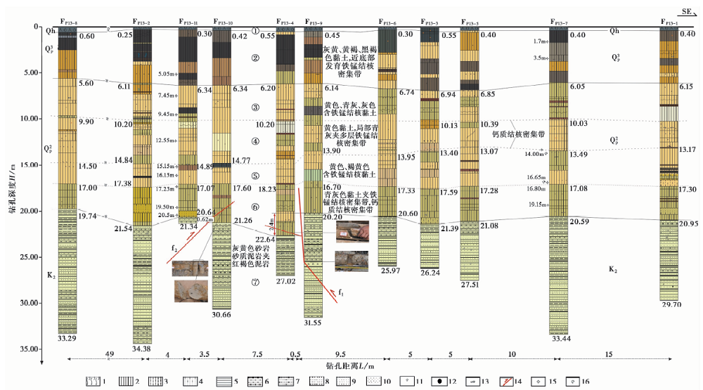
图 7 合铜路钻孔联合地质剖面1 淤泥; 2 黏土; 3 粉砂质黏土; 4 细砂质黏土; 5 泥岩; 6 粉砂质泥岩; 7 泥质粉砂岩; 8 粉砂岩; 9 细砂岩; 10 中粗砂岩;11 砾石; 12 铁锰结核; 13 钙质结核; 14 断层; 15 光释光样品; 16 电子自旋共振测年样品
Fig. 7 The composite drilling geological section at Hetong road.
| [1] | 安徽省地质矿产局. 1987. 安徽省区域地质志 [M]. 北京: 地质出版社. |
| Bureau of Geology and Mineral Resources of Anhui Province. 1987. Regional Geology of Anhui [M]. Geological Publishing House, Beijing(in Chinese). | |
| [2] | 曹筠, 冉勇康, 许汉刚, 等. 2018. 郯庐断裂带江苏段安丘-莒县断裂全新世活动及其构造意义[J]. 地球物理学报, 61(7): 2828—2844. |
| CAO Jun, RAN Yong-kang, XU Han-gang, et al.2018. Holocene activity of the Anqiu-Juxian Fault on the Jiangsu segment of the Tanlu fault zone and its tectonics implication[J]. Chinese Journal of Geophysics, 61(7): 2828—2844(in Chinese). | |
| [3] | 曹筠, 许汉刚, 冉勇康, 等. 2017. 郯庐断裂带沂水-汤头断裂南段晚第四纪活动新证及构造意义[J]. 地震地质, 39(2): 287—303. doi: 10.3969/j.issn.0253-4967.2017.02.003. |
| CAO Jun, XU Han-gang, RAN Yong-kang, et al.2017. New evidences for late Quaternary activity in the southern segment of the Yishu-Tangtou Fault, the Tan-Lu fault zone, and its tectonic implication[J]. Seismology and Geology, 39(2): 287—303(in Chinese). | |
| [4] | 晁洪太, 李家灵, 崔昭文, 等.1994. 郯庐断裂带中段全新世活断层的几何结构与分段 [G]∥国家地震局地质研究所. 活动断裂研究(3). 北京: 地震出版社: 180—190. |
| CHAO Hong-tai, LI Jia-ling, CUI Zhao-wen, et al.1994. Geometry and segmentation of the Quaternary fault in the middle segment of Tanlu fault zone [G]∥ Institute of Geology, State Seismological Bureau. Research of Active Fault (3). Seismological Press, Beijing: 180—190(in Chinese). | |
| [5] | 方仲景, 丁梦林, 向宏发, 等. 1987. 郯庐断裂带 [M]. 北京: 地震出版社. |
| FANG Zhong-jing, DING Meng-lin, XIANG Hong-fa, et al.1987. The Tanlu Fault Zone [M]. Seismological Press, Beijing(in Chinese). | |
| [6] | 李家灵, 晁洪太, 崔昭文, 等. 1994. 郯庐活断层的分段及其大震危险性分析[J]. 地震地质, 16(2): 121—126. |
| LI Jia-ling, CHAO Hong-tai, CUI Zhao-wen, et al.1994. Segmentation of active fault along the Tancheng-Lujiang fault zone and evaluation of strong earthquake risk[J]. Seismology and Geology, 16(2): 121—126(in Chinese). | |
| [7] | 施炜, 张岳桥, 董树文. 2003. 郯庐断裂带中段第四纪活动及其分段特征[J]. 地球学报, 24(1): 11—18. |
| SHI Wei, ZHANG Yue-qiao, DONG Shu-wen.2003. Quaternary activity and segmentation behavior of the middle portion of the Tan-Lu fault zone[J]. Acta Geoscientica Sinica, 24(1): 11—18(in Chinese). | |
| [8] | 王志才, 贾荣光, 孙昭民, 等. 2005. 沂沭断裂带安丘-莒县断裂安丘—朱里段几何结构与活动特征[J]. 地震地质, 27(2): 212—220. |
| WANG Zhi-cai, JIA Rong-guang, SUN Zhao-min, et al.2005. Geometry and activity of the Anqiu-Zhuli segment of the Anqiu-Juxian Fault in the Yishu fault zone[J]. Seismology and Geology, 27(2): 212—220(in Chinese). | |
| [9] | 许汉刚, 范小平, 冉勇康, 等. 2016. 郯庐断裂带宿迁段F5断裂浅层地震勘探新证据[J]. 地震地质, 38(1): 31—43.doi: 10.3969/j.issn.0253-4967.2016.01.013. |
| XU Han-gang, FAN Xiao-ping, RAN Yong-kang, et al.2016. New evidences of the Holocene fault in Suqian segment of the Tanlu fault zone discovered by shallow seismic exploration method[J]. Seismology and Geology, 38(1): 31—43(in Chinese). | |
| [10] | 徐嘉炜, 马国锋. 1992. 郯庐断裂带研究的十年回顾[J]. 地质论评, 38(4): 316—324. |
| XU Jia-wei, MA Guo-feng.1992. Review of the years(1981—1991) of the research on the Tancheng-Lujiang fault zone[J]. Geological Review, 38(4): 316—324(in Chinese). | |
| [11] | 徐嘉炜, 朱光. 1995. 中国东部郯庐断裂带构造模式讨论[J]. 华北地质矿产杂志, 10(2): 121—134. |
| XU Jia-wei, ZHU Guang.1995. Discussion on the tectonic models for the Tan-Lu fault zone, eastern China[J]. Journal of Geology and Mineral Resources of North China, 10(2): 121—134(in Chinese). | |
| [12] | 杨源源, 赵朋, 郑海刚, 等. 2017. 郯庐断裂带安徽紫阳山段发现全新世活动证据[J]. 地震地质, 39(4): 644—655. doi: 10.3969/j.issn.0253-4967.2017.04.002. |
| YANG Yuan-yuan, ZHAO Peng, ZHENG Hai-gang, et al.2017. Evidence of Holocene activity discovered in Anhui Ziyangshan segment of Tanlu fault zone[J]. Seismology and Geology, 39(4): 644—655(in Chinese). | |
| [13] | 姚大全, 郑海刚, 赵朋, 等. 2017. 郯庐断裂带淮河南到女山湖段晚第四纪以来的新活动[J]. 中国地震, 33(1): 38—45. |
| YAO Da-quan, ZHENG Hai-gang, ZHAO Peng, et al.2017. New activity of the Tanlu fault zone from Huaihe to the Nüshanhu since the Late Quaternary[J]. Earthquake Research in China, 33(1): 38—45(in Chinese). | |
| [14] | 张鹏, 李丽梅, 冉勇康, 等. 2015. 郯庐断裂带安丘-莒县断裂江苏段晚第四纪活动特征研究[J]. 地震地质, 37(4): 1162—1176. doi: 10.3969/j.issn.0253-4967.2015.04.018. |
| ZHANG Peng, LI Li-mei, RAN Rong-kang, et al.2015. Research on characteristics of Late Quaternary activity of the Jiangsu segment of Anqiu-Juxian Fault in the Tanlu fault zone[J]. Seismology and Geology, 37(4): 1162—1176(in Chinese). | |
| [15] | 郑颖平, 姚大全, 张毅, 等. 2014. 郯庐断裂带新沂—五河段晚第四纪活动的新证据[J]. 中国地震, 30(1): 23—29. |
| ZHENG Ying-ping, YAO Da-quan, ZHANG Yi, et al.2014. New evidence of Late Quaternary activity in the segment from Xinyi to Wuhe in the Tancheng-Lujiang fault zone[J]. Earthquake Research in China, 30(1): 23—29(in Chinese). | |
| [16] | 朱光, 牛漫兰, 刘国生, 等. 2005. 郯庐断裂带肥东段走滑运动的 40Ar/39Ar法定年[J]. 地质学报, 79(3): 303—316. |
| ZHU Guang, NIU Man-lan, LIU Guo-sheng, et al.2005. 40Ar/39Ar dating for the strike-slip movement on the Feidong part of Tanlu fault belt[J]. Acta Geologica Sinica, 79(3): 303—316(in Chinese). | |
| [17] | Gilder S A, Leloup P H, Courtillot V, et al.1999. Tectonic evolution of the Tancheng-Lujiang(Tan-Lu)Fault via Middle Triassic to Early Cenozoic paleomagnetic data[J]. Journal of Geophysical Research: Solid Earth, 104(B7): 15365—15390. |
| [18] | Shu P, Fang L H, Zheng Y P, et al.2016. Geological evidence and characteristics of activity of the Wuhe-Mingguang section of Tancheng-Lujiang fault zone in Late Pleistocene[J]. Earthquake Research in China, 30(4): 485—499. |
| [19] | Xu J W, Zhu G, Tong W X, et al.1987. Formation and evolution of the Tancheng-Lujiang wrench fault system: A major shear system to the northwest of the Pacific Ocean[J]. Tectonophysics, 134(4): 273—310. |
| [20] | Yin A, Nie S Y.1993. An indentation model for the North and South China collision and the development of the Tan-Lu and Honam fault systems, eastern Asia[J]. Tectonics, 12(4): 801—813. |
| [1] | 赵朋, 李军辉, 陶月潮, 疏鹏, 方震. 郯庐断裂带女山湖北侧探槽的新活动现象及讨论[J]. 地震地质, 2023, 45(2): 338-354. |
| [2] | 郑海刚, 姚大全, 赵朋, 杨源源, 黄金水. 郯庐断裂带赤山段全新世新活动的特征[J]. 地震地质, 2023, 45(1): 127-138. |
| [3] | 田一鸣, 杨卓欣, 王志铄, 石金虎, 张扬, 谭雅丽, 张建志, 宋威, 季通宇. 新乡-商丘断裂封丘段浅部探测和第四纪活动性的初步研究[J]. 地震地质, 2023, 45(1): 139-152. |
| [4] | 杨源源, 李鹏飞, 路硕, 疏鹏, 潘浩波, 方良好, 郑海刚, 赵朋, 郑颖平, 姚大全. 郯庐断裂带中段F5断裂淮河-女山湖段的古地震与垂直滑动速率[J]. 地震地质, 2022, 44(6): 1365-1383. |
| [5] | 秦晶晶, 刘保金, 王志才, 酆少英, 邓小娟, 花鑫升, 李倩. 利用地震反射剖面探测研究安丘-莒县断裂板泉段的浅部构造特征[J]. 地震地质, 2022, 44(2): 349-362. |
| [6] | 孙业君, 黄耘, 刘泽民, 郑建常, 江昊琳, 李婷婷, 叶青, 方韬. 郯庐断裂带鲁苏皖段及邻区构造应力场特征及其动力学意义[J]. 地震地质, 2021, 43(5): 1188-1207. |
| [7] | 计昊旻, 李安, 张世民. 基于冲沟右旋水平位错的安丘-莒县断裂地震特征位移分析[J]. 地震地质, 2021, 43(3): 471-487. |
| [8] | 顾勤平, 康清清, 张鹏, 孟科, 吴珊珊, 李正楷, 王俊菲, 黄群, 蒋新, 李大虎. 郯庐断裂带中南段及邻区Rayleigh波相速度与方位各向异性[J]. 地震地质, 2020, 42(5): 1129-1152. |
| [9] | 顾勤平, 许汉刚, 晏云翔, 赵启光, 李丽梅, 孟科, 杨浩, 王金艳, 蒋新, 马董伟. 郯庐断裂带新沂段地壳浅部结构和断裂活动性探测[J]. 地震地质, 2020, 42(4): 825-843. |
| [10] | 章鑫, 杜学彬. 郯庐断裂带南段对近地表大地电流的分异性[J]. 地震地质, 2020, 42(4): 909-922. |
| [11] | 张继红, 赵国泽, 董泽义, 王立凤, 韩冰, 王庆林, 唐廷梅, 王梅. 郯庐断裂带安丘、莒县电磁台地壳电性结构研究[J]. 地震地质, 2019, 41(5): 1239-1253. |
| [12] | 张鹏, 张媛媛, 李丽梅, 蒋新, 孟科. 郯庐断裂带安丘-莒县断裂江苏段全新世活动的新证据[J]. 地震地质, 2019, 41(3): 576-586. |
| [13] | 翁爱华, 李建平, 范小平, 李斯睿, 韩江涛, 李大俊, 李亚彬, 赵祥阳, 唐裕. 大地电磁测深揭示的1668年郯城8.5级地震震中地壳精细结构[J]. 地震地质, 2018, 40(2): 396-409. |
| [14] | 赵朋, 姚大全, 杨源源, 郑海刚, 王行舟, 许洪泰, 方震. 郯庐断裂带安徽浮山段晚第四纪以来活动新发现[J]. 地震地质, 2017, 39(5): 889-903. |
| [15] | 杨源源, 赵朋, 郑海刚, 姚大全, 王行舟, 缪鹏, 李军辉, 汪小厉, 疏鹏. 郯庐断裂带安徽紫阳山段发现全新世活动证据[J]. 地震地质, 2017, 39(4): 644-655. |
| 阅读次数 | ||||||
|
全文 |
|
|||||
|
摘要 |
|
|||||
