地震地质 ›› 2021, Vol. 43 ›› Issue (6): 1485-1506.DOI: 10.3969/j.issn.0253-4967.2021.06.008
张恩会1)( ), 师亚芹1),*(), 张艺1), 李苗1), 李高阳1), 裴跟弟2), 王万合2)
收稿日期:2020-11-25
修回日期:2021-05-11
出版日期:2021-12-20
发布日期:2022-01-29
通讯作者:
师亚芹
作者简介:张恩会, 女, 1985年生, 2015年于中国地震局地球物理研究所获固体地球物理专业硕士学位, 工程师, 主要从事活断层探测与地球结构成像工作, 电话: 029-88465376, E-mail: zehll@163.com。
基金资助:
ZHANG En-hui1)(), SHI Ya-qin1),*(), ZHANG Yi1), LI Miao1), LI Gao-yang1), PEI Gen-di2), WANG Wan-he2)
Received:2020-11-25
Revised:2021-05-11
Online:2021-12-20
Published:2022-01-29
Contact:
SHI Ya-qin
摘要:
渭河盆地新生代以来断裂活动和沉积作用强烈, 隐伏活动断裂发育, 近EW向的桃川-户县断裂是其中之一。探明桃川-户县断裂在渭河盆地中的展布位置、 结构特征以及晚第四纪活动性, 对于当地的地震构造及强震危险研究具有重要意义。为此, 文中依托“兴平活断层项目”布设了7条浅层地震测线, 基于探测结果并结合已有的浅层和中深层地震剖面确定了桃川-户县断裂及其次级断裂在渭河盆地内的存在与隐伏位置。结果显示, 桃川-户县断裂(F8)西与太白盆地南缘断裂相连, 自周至县汤峪镇穿出秦岭北缘进入渭河盆地后隐伏于地表松散层之下; 先呈NE走向斜穿周至县城, 向E逐渐转向近EW走向, 在周至和户县之间呈现局部朝N凸出的弧形展布, 再向E至户县引镇附近与铁炉子断裂相接。另在周至北和户县北之间存在与F8断裂大致平行展布的反向次级断裂(DF3)。文中还揭示出在渭河盆地中段, 秦岭北缘断裂、 渭河断裂和桃川-户县断裂连同它们的分支断裂一起构成了1个大型的负花状结构断裂带; 其中F8和DF3断裂及其次级断裂组成1个次级的负花状构造带。结合相关的钻孔剖面等信息的分析表明, 在研究区内, 以F8断裂为主断裂的构造带自晚更新世以来是活动的, 属于活动断裂。文中最后讨论了渭河盆地内的断裂带表现出负花状而非阶梯状结构的可能原因。
中图分类号:
张恩会, 师亚芹, 张艺, 李苗, 李高阳, 裴跟弟, 王万合. 桃川-户县断裂渭河盆地隐伏段的展布与结构特征[J]. 地震地质, 2021, 43(6): 1485-1506.
ZHANG En-hui, SHI Ya-qin, ZHANG Yi, LI Miao, LI Gao-yang, PEI Gen-di, WANG Wan-he. EXTENSION AND STRUCTURAL FEATURE OF THE BURIED SEGMENT OF TAOCHUAN-HUXIAN FAULT IN THE WEIHE BASIN[J]. SEISMOLOGY AND EGOLOGY, 2021, 43(6): 1485-1506.

图 1 桃川-户县断裂与本文研究区位置图 区域位置图中的地块划分方案据中国地质图集(2002); 断层分布据陕西省地震局“关中大震项目”研究成果
Fig. 1 Map showing positions of the Taochuan-Huxian Fault and the study area.
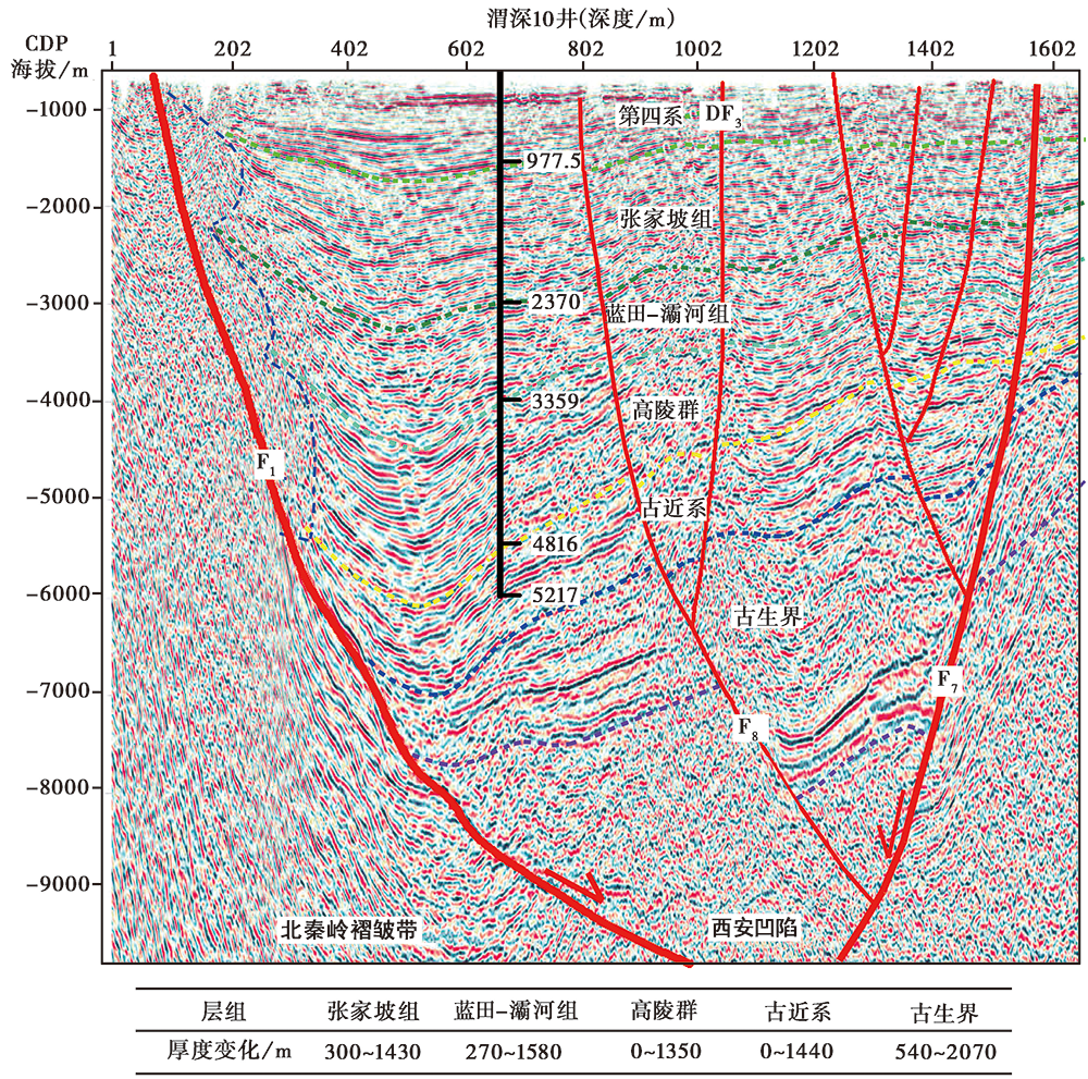
图 2 户县-乾县中深层地震反射剖面及断层解释 测线位置见图1和图3。地震反射剖面及地层解释据文献①(①陕西省地质调查中心,2015,渭河盆底基底探测与选区地球物理攻关项目。)
Fig. 2 Seismic reflection section of the profile Huxian-Qianxian with fault interpretations.
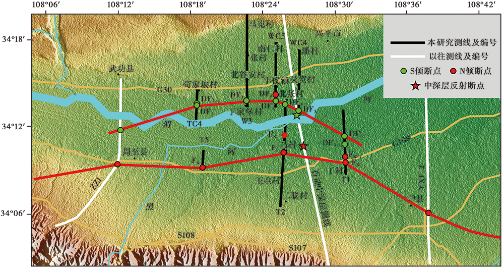
图 3 本研究开展的浅层地震勘探测线位置简图
Fig. 3 Map showing locations of the lines for shallow reflection seismic surveys.
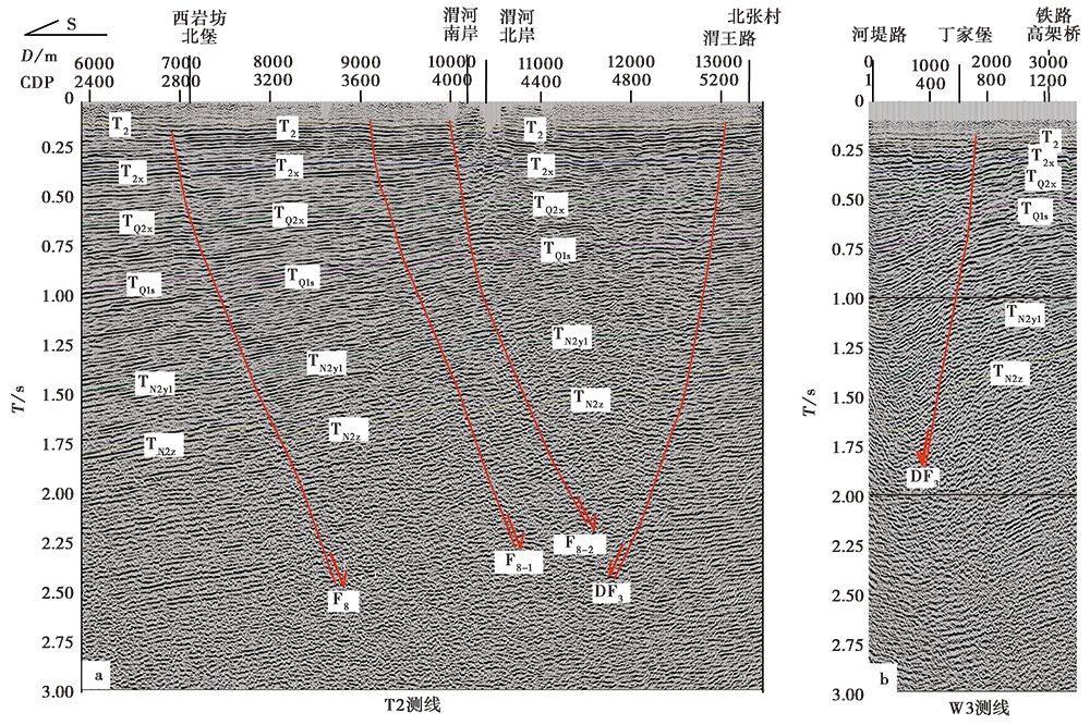
图 4 T2与W3测线的叠加时间剖面及主要断裂解释图
Fig. 4 Stacked time sections of seismic reflection profiles T2(a)and W3(b)with interpretations of primary faults.

图 5 T2与W3测线深度剖面解释图 各反射波组代号(T2、 T2x、 TQ2x、 TQ1s、 TN2y1、 TN2z和TN2b)对应的地层单元见3.2节最后自然段的描述, 下同
Fig. 5 Interpreted depth sections of seismic reflection profiles T2(a)and W3(b).
| 测线名称 | 断点编号 | 断点位置 | 断层性质 | 视倾向 | 视倾角 | 可分辨的上断点埋深 /m | |
|---|---|---|---|---|---|---|---|
| 经度 | 纬度 | ||||||
| T2 | F8 | 108°25'47″E | 34°10'15″N | 正断层 | N | 50°~68° | 63 |
| F8-1 | 108°25'52″E | 34°11'28″N | 正断层 | N | 32°~72° | 89 | |
| F8-2 | 108°25'55″E | 34°11'56″N | 正断层 | N | 44°~70° | 83 | |
| DF3 | 108°25'54″E | 34°13'35″N | 正断层 | S | 40°~76° | 56 | |
| W3 | DF3 | 108°22'45″E | 34°13'51″N | 正断层 | S | 32°~75° | 87 |
| T1 | F8 | 108°30'55″E | 34°09'34″N | 正断层 | N | 71° | 50 |
| F8-1 | 108°30'55″E | 34°09'52″N | 正断层 | N | 72° | 51 | |
| DF3 | 108°30'50″E | 34°11'23″N | 正断层 | S | 68° | 43 | |
| DF3-1 | 108°30'52″E | 34°10'49″N | 正断层 | S | 71° | 53 | |
| T5 | F8 | 108°18'02″E | 34°08'28″N | 正断层 | N | 62°~75° | 117 |
| TC4 | DF3 | 108°18'33″E | 34°13'29″N | 正断层 | S | 70° | 62 |
| DF3-1 | 108°18'34″E | 34°13'38″N | 正断层 | S | 68° | 81 | |
| WC5 | DF3 | 108°25'07″E | 34°13'48″N | 正断层 | S | 73° | 48 |
| DF4 | 108°25'06″E | 34°14'15″N | 正断层 | N | 52°~73° | 43 | |
| WC4 | DF3 | 108°27'01″E | 34°13'09″N | 正断层 | S | 63° | 37 |
表1 浅层地震测线及发现的断点参数表
Table1 The shallow seismic reflection profiles and parameters of the observed breakpoints
| 测线名称 | 断点编号 | 断点位置 | 断层性质 | 视倾向 | 视倾角 | 可分辨的上断点埋深 /m | |
|---|---|---|---|---|---|---|---|
| 经度 | 纬度 | ||||||
| T2 | F8 | 108°25'47″E | 34°10'15″N | 正断层 | N | 50°~68° | 63 |
| F8-1 | 108°25'52″E | 34°11'28″N | 正断层 | N | 32°~72° | 89 | |
| F8-2 | 108°25'55″E | 34°11'56″N | 正断层 | N | 44°~70° | 83 | |
| DF3 | 108°25'54″E | 34°13'35″N | 正断层 | S | 40°~76° | 56 | |
| W3 | DF3 | 108°22'45″E | 34°13'51″N | 正断层 | S | 32°~75° | 87 |
| T1 | F8 | 108°30'55″E | 34°09'34″N | 正断层 | N | 71° | 50 |
| F8-1 | 108°30'55″E | 34°09'52″N | 正断层 | N | 72° | 51 | |
| DF3 | 108°30'50″E | 34°11'23″N | 正断层 | S | 68° | 43 | |
| DF3-1 | 108°30'52″E | 34°10'49″N | 正断层 | S | 71° | 53 | |
| T5 | F8 | 108°18'02″E | 34°08'28″N | 正断层 | N | 62°~75° | 117 |
| TC4 | DF3 | 108°18'33″E | 34°13'29″N | 正断层 | S | 70° | 62 |
| DF3-1 | 108°18'34″E | 34°13'38″N | 正断层 | S | 68° | 81 | |
| WC5 | DF3 | 108°25'07″E | 34°13'48″N | 正断层 | S | 73° | 48 |
| DF4 | 108°25'06″E | 34°14'15″N | 正断层 | N | 52°~73° | 43 | |
| WC4 | DF3 | 108°27'01″E | 34°13'09″N | 正断层 | S | 63° | 37 |
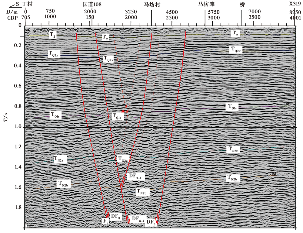
图 6 T1测线时间剖面及主要断裂解释图
Fig. 6 Stacked time section of seismic reflection profile T1 with interpretation of primary faults.
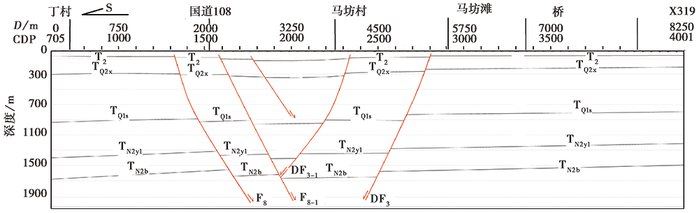
图 7 T1测线的深度剖面解释图
Fig. 7 Interpreted depth sections of seismic reflection profile T1.
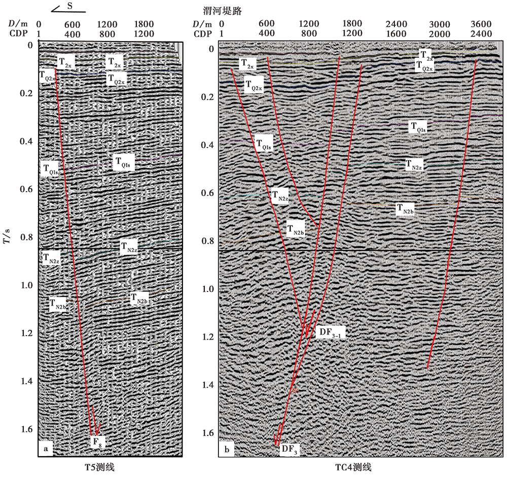
图 8 T5和TC4测线的时间剖面及主要断裂解释图
Fig. 8 Stacked time sections of seismic reflection profiles T5(a) and TC4(b) with interpretations of primary faults.
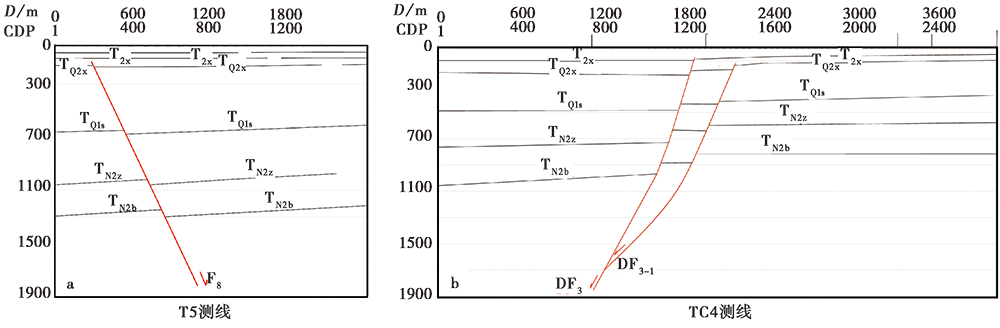
图 9 T5和TC4测线的深度剖面解释图
Fig. 9 Interpreted depth sections of seismic reflection profiles T5(a) and TC4(b).
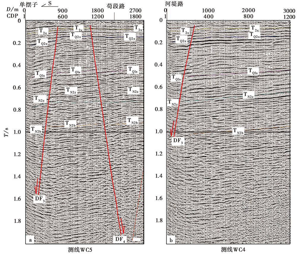
图 10 WC5测线(a)与WC4测线(b)的时间剖面及主要断裂解释图
Fig. 10 Stacked time sections of seismic reflection profiles WC5(a) and WC4(b) with interpretations of primary faults.
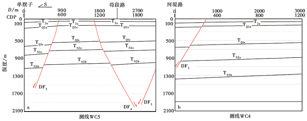
图 11 WC5测线(a)与WC4测线(b)的深度剖面解释图
Fig. 11 Interpreted depth sections of seismic reflection profiles WC5(a) and WC4(b).
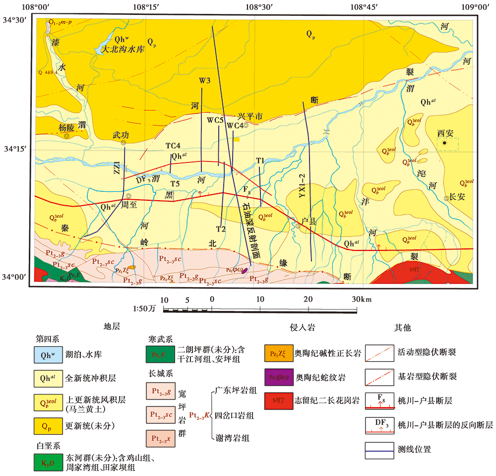
图 12 本研究探明的桃川-户县断裂(F8)隐伏段及其反向次级断裂(DF3)展布图 地质底图来自陕西省地质矿产勘查开发局
Fig. 12 Map showing the extensions of the buried segments of the Taochuan-Huxian Fault(F8) and its antithetic fault(DF3).
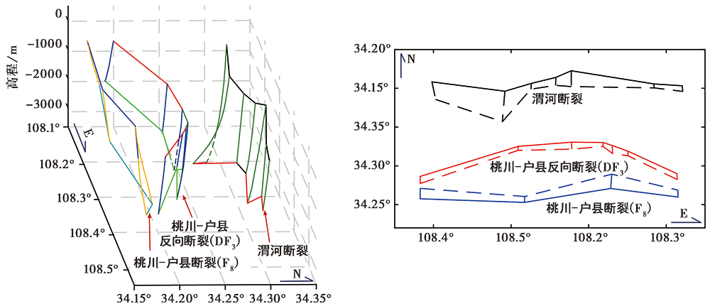
图 13 桃川-户县断裂(F8)及其反向次级断裂(DF3)与渭河断裂展布关系的立体示意图(a)和平面示意图(b) 中的虚线示意断层向下延伸的部分
图b A 3D sketch(a)and a 2D sketch(b)both showing the spatial distribution relation among the Weihe Fault, the Taochuan-Huxian Fault(F8)and its antithetic fault(DF3).
| [1] | 常利军, 王椿镛, 丁志峰. 2011. 鄂尔多斯块体及周缘上地幔各向异性研究[J]. 中国科学(D辑), 41(5): 686-699. |
| CHANG Li-jun, WANG Chun-yong, DING Zhi-feng. 2011. Upper mantle anisotropy in the Ordos Block and its margins[J]. Seince China: Earth seince, 41(5): 686-699(in Chinese). | |
| [2] | 邓起东, 程绍平, 闵伟, 等. 1999. 鄂尔多斯块体新生代构造活动和动力学的讨论[J]. 地质力学学报, 15(3): 13-21. |
| DENG Qi-dong, CHENG Shao-ping, MIN Wei, et al. 1999. Discussion on Cenozoic tetonics and dynamics of Ordos block[J]. Journal of Geomechanics, 15(3): 13-21(in Chinese). | |
| [3] | 邓起东, 卢造勋, 杨主恩. 2007. 城市活动断层探测和断层活动性评价问题[J]. 地震地质, 29(2): 189-200. |
| DENG Qi-dong, LU Zao-xun, YANG Zhu-en. 2007. Exploration and seismic hazard assessment of active faults in urban areas[J]. Seismology and Geology, 29(2): 189-200(in Chinese). | |
| [4] | 邓亚虹, 彭建兵, 李丽, 等. 2013. 渭河盆地基底伸展与地裂缝成因关系探讨[J]. 工程地质学报, 21(1): 92-96. |
| DENG Ya-hong, PENG Jian-bing, LI Li, et al. 2013. Causative relationship between basement stretching and ground fissures formation in Weihe Basin[J]. Journal of Engineering Geology, 21(1): 92-96(in Chinese). | |
| [5] | 杜建军. 2016. 渭河盆地东南缘主要断裂晚更新世以来的活动性及灾害效应[J]. 北京: 中国地质科学院. |
| DU Jian-jun. 2016. Activity of main faults and related geohazard effects in southeast of Weihe Basin[J]. Chinese Academy of Geological Sciences, Beijing(in Chinese). | |
| [6] |
冯红武, 颜文华, 严珊, 等. 2019. 背景噪声和地震面波联合反演渭河盆地及邻区壳幔S波速度结构[J]. 地震地质, 41(5): 1185-1205. doi: 10.3969/j.issn.0253.4967.2019.05.008.
DOI |
| FENG Hong-wu, YAN Wen-hua, YAN Shan, et al. 2019. Joint inversion of ambient moise and surface wave for S-wave velocity of the crust and uppermost mantle beneath Weihe Basin and its adjacent area[J]. Seismology and Geology, 41(5): 1185-1205(in Chinese). | |
| [7] | 国家地震局“鄂尔多斯周缘活动断裂系”课题组. 1988. 鄂尔多斯周缘活动断裂系[M]. 北京: 地震出版社. |
| The Research Group on “Active Fault System around Ordos Massif”, State Seismological Bureau. 1988. Active Fault System around Ordos Massif[M]. Seismological Press, Beijing(in Chinese). | |
| [8] | 韩恒悦, 张逸, 袁志祥. 2002. 渭河断陷盆地带的形成演化及断块运动[J]. 地震研究, 25(4): 362-368. |
| HAN Heng-yue, ZHANG Yi, YUAN Zhi-xiang. 2002. The evolution of Weihe down-faulted basin and the movement of the fault blocks[J]. Journal of Seismological Research, 25(4): 362-368(in Chinese). | |
| [9] | 郝明, 秦姗兰, 李煜航, 等. 2014. 青藏高原东北缘近期地壳水平运动研究[J]. 大地测量与地球动力学, 34(3): 99-103. |
| HAO Ming, QIN Shan-lan, LI Yu-hang, et al. 2014. Recent horizontal velocity field of northeastern Tibetan plateau[J]. Journal of Geodesy and Geodynamics, 34(3): 99-103(in Chinese). | |
| [10] | 胡国泽, 滕吉文, 阮小敏, 等. 2014. 秦峻造山带和邻域磁异常特征及结晶基底变异分析[J]. 地球物理学报, 57(2): 556-571. |
| HU Guo-ze, TENG Ji-wen, RUAN Xiao-min, et al. 2014. Magmetic anomaly characteristics and crystalline basement variation of the Qinling orogenic belt and its adjacent areas[J]. Chinese Journal of Geophysics, 57(2): 556-571(in Chinese). | |
| [11] | 李玉宏, 王行运, 韩伟, 等. 2013. 陕西渭河盆地固市凹陷渭热2井组甲烷气成因及其意义[J]. 地质通报, 32(11): 1790-1797. |
| LI Yu-hong, WANG Xing-yun, HAN Wei, et al. 2013. The genesis of methane in Weire 2 well of Gushi depression, Weihe Basin, Shaanxi Province and its significance[J]. Geological Bulletin of China, 32(11): 1790-1797(in Chinese). | |
| [12] | 李智超. 2017. 渭河盆地新生代岩相古地理及环境演化[D]. 西安: 西北大学. |
| LI Zhi-chao. 2017. The lithofacies paleogeography and paleoenvironmental evolution of the Cenozoic in the Weihe Basin, China[D]. Northwest University, Xi'an(in Chinese). | |
| [13] | 马冀. 2019. 1556年华县M8¼级地震地表破裂与发震构造[D]. 北京: 中国地震局地质研究所. |
| MA Ji. 2019. Surface repture and its seismogenic faults of 1556 Huaxian M8¼ earthquake[D]. Institute of Geology, China Earthquake Administration, Beijing(in Chinese). | |
| [14] | 彭建兵. 1992. 渭河断裂带的构造演化与地震活动[J]. 地震地质, 14(2): 113-120. |
| PENG Jian-bing. 1992. Tectonic evolution and seismicity of Weihe fault zone[J]. Seismology and Geology, 14(2): 113-120(in Chinese). | |
| [15] | 瞿伟, 王运生, 徐超, 等. 2017. 渭河盆地深大断裂处构造应力特征及其活动特性[J]. 武汉大学学报(信息科学版), 42(6): 825-830. |
| QU Wei, WANG Yun-sheng, XU Chao, et al. 2017. Current tectonic stress and activities characteristics of the deep faults within Weihe Basin[J]. Geomatics and Information Science of Wuhan University, 42(6): 825-830(in Chinese). | |
| [16] | 任隽, 冯希杰, 王夫运, 等. 2013. 深地震反射剖面揭示的渭河盆地西安坳陷的地壳精细结构[J]. 地球物理学报, 56(2): 513-521. |
| REN Jun, FENG Xi-jie, WANG Fu-yun, et al. 2013. Fine crust structures of Xi'an sag in the Weihe Basin revealed by a deep seismic reflection profle[J]. Chinese Journal of Geophysics, 56(2): 513-521(in Chinese). | |
| [17] | 司芗, 滕吉文, 刘有山, 等. 2016. 秦岭造山带与南北相邻地带远震接收函数与地壳结构[J]. 地球物理学报, 59(4): 1321-1334. |
| SI Xiang, TENG Ji-wen, LIU You-shan, et al. 2016. Crust structure of the Qinling orogenic and the region on its north and south margins from teleseismic receiver function[J]. Chinese Journal of Geophysics, 59(4): 1321-1334(in Chinese). | |
| [18] | 田优平, 唐红亮, 康承旭, 等. 2020. 综合震源机制解法反演湖南地区构造应力场的初步结果[J]. 地球物理学报, 63(11): 4080-4096. |
| TIAN You-ping, TANG Hong-liang, KANG Cheng-xu, et al. 2020. Preliminary results of inversion of tectonic stress field in Hunan region by the composite focal mechanism method[J]. Chinese Journal of Geophysics, 63(11): 4080-4096(in Chinese). | |
| [19] | 汪素云, 陈培善. 1980. 中国及邻区现代构造应力场的数值模拟[J]. 地球物理学报, 23(1): 35-45. |
| WANG Su-yun, CHEN Pei-shan. 1980. A numerical simulation of the present tectonic stress field of China and its vicinity[J]. Chinese Journal of Geophysics, 23(1): 35-45(in Chinese). | |
| [20] | 王景明. 1984. 渭河地堑断裂构造研究[J]. 地质论评, 30(3): 217-223. |
| WANG Jing-ming. 1984. A study on the tectonics of the Weihe River graben[J]. Geological Review, 30(3): 217-223(in Chinese). | |
| [21] | 王红伟, 刘宝宪, 马占荣, 等. 2010. 渭河盆地前新生界分布的物探特征及油气成藏条件分析[J]. 地球物理学进展, 25(4): 1280-1287. |
| WANG Hong-wei, LIU Bao-xian, MA Zhan-rong, et al. 2010. Analysis of distribution of geophysical characteristics and reservoir-forming conditions in the pre-Cenozoic strata in the Weihe Basin[J]. Progress in Geophsics, 25(4): 1280-1287(in Chinese). | |
| [22] | 王燮培, 谢德宜. 1989. 中国含油气盆地中花状构造的发现及其石油地质意义[J]. 地质科技情报, 8(2): 59-66. |
| WANG Xie-pei, XIE De-yi. 1989. Finding flower structures in China's oil and gas bearing basins and its significance in petroleum geology[J]. Geological Science and Technology Information, 8(2): 59-66(in Chinese). | |
| [23] | 肖秋生. 2017. 骊山山前断裂的展布与活动性研究[D]. 河北, 防灾科技学院. |
| XIAO Qiu-sheng. 2017. Distribution of Lishan front fault and its activity[D]. Institute of Disaster Prevention, Hebei(in Chisese). | |
| [24] | 许顺山, 彭华, Nieto-Samaniego A F, 等. 2017. 里德尔剪切的组合型式与走滑盆地组合型式的相似性[J]. 地质论评, 63(2): 287-301. |
| XU Shun-shan, PENG Hua, Nieto-Samaniego A F, et al. 2017. The similarity between Riedel shear patterns and strike-slip basin patterns[J]. Geological Review, 63(2): 287-301(in Chinese). | |
| [25] | 杨超. 2013. 关中盆地地震、 测井资料精细解释及构造特征研究[D]. 西安: 西安石油大学. |
| YANG Chao. 2013. Study on tectonic properties and precision interpretation of well logging and seismic data in Guanzhong Basin[D]. Xi'an Shiyou University, Xi'an(in Chinese). | |
| [26] | 杨晓平, 邓起东, 冯希杰. 2005. 东秦岭内部铁炉子断裂带的最新走滑活动[J]. 中国地震, 21(2): 172-183. |
| YANG Xiao-ping, DENG Qi-dong, FENG Xi-jie. 2005. The Tieluzi Fault in interior of eastern Qinling Mountains: An active strike-slip fault[J]. Earthquake Research in China, 21(2): 172-183(in Chinese). | |
| [27] | 虞廷林. 1994. 中国东部应力场与板块运动[J]. 地震学刊, (2): 13-17. |
| YU Ting-lin. 1994. Stress field and plate motions in eastern area of China[J]. Journal of Seismology, (2): 13-17(in Chinese). | |
| [28] | 张朝锋. 2011. 渭河地堑的形成演化及其动力学机制[D]. 西安: 西北大学. |
| ZHANG Chao-feng. 2011. Evolution and dynamics mechanism of Weihe graben[D]. Northwest University, Xi'an(in Chinese). | |
| [29] | 张国伟, 张本仁, 袁学诚, 等. 2001. 秦岭造山带与大陆动力学[M]. 北京, 科学出版社. |
| ZHANG Guo-wei, ZHANG Ben-ren, YUAN Xue-cheng, et al. 2001. Qinling Orogenic Belt and Continental Dynamics[M]. Seince Press, Beijing(in Chinese). | |
| [30] | 张宏卫, 邓起东. 1992. 不对称盆地形成机制探讨: 以渭河盆地为例[J]. 中国地震, 8(1): 28-37. |
| ZHANG Hong-wei, DENG Qi-dong. 1992. A study on the mechanism of the asymmetry basin: A case of the Weihe Basin[J]. Earthquake Research in China, 8(1): 28-37(in Chinese). | |
| [31] | 张培震, 甘卫军, 沈正康, 等. 2005. 中国大陆现今构造作用的地块运动和连续变形耦合模型[J]. 地质学报, 79(6): 748-756. |
| ZHANG Pei-zhen, GAN Wei-jun, SHEN Zheng-kang, et al. 2005. A coupling model of rigid-block movement and continuous deformation: Patterns of the present-day deformation of China's continent and its vicinity[J]. Acta Geologica Sinica, 79(6): 748-756(in Chinese). | |
| [32] | 张勤, 瞿伟, 彭建兵, 等. 2012. 渭河盆地地裂缝群发机理及东、 西部地裂缝分布不均衡构造成因研究[J]. 地球物理学报, 55(8): 2589-2597. |
| ZHANG Qin, QU Wei, PENG Jian-bing, et al. 2012. Research on tectonic causes of numerous ground fissures development mechanism and its unbalance distribution between eastern and western of Weihe Basin[J]. Chinese Journal of Geophysics, 55(8): 2589-2597(in Chinese). | |
| [33] | 郑文俊, 张培震, 袁道阳, 等. 2019. 中国大陆活动构造基本特征及其对区域动力过程的控制[J]. 地质力学学报, 25(5): 699-721. |
| ZHENG Wen-jun, ZHANG Pei-zhen, YUAN Dao-yang, et al. 2019. Basic characteristics of active tectonics and associated geodynamic processes in continental China[J]. Journal of Geomechanics, 25(5): 699-721(in Chinese). | |
| [34] | 周厚云, 韩慕康, 侯建军. 2001. 东秦岭铁炉子断裂的新活动特征[J]. 地震地质, 23(3): 390-398. |
| ZHOU Hou-yun, HAN Mu-kang, HOU Jian-jun. 2001. Characteristics of recent activity of the Tieluzi Fault in east Qinling Mountains[J]. Seismology and Geology, 23(3): 390-398(in Chinese). | |
| [35] |
Chang L J, Ding Z F, Wang C Y, et al. 2017. Vertical coherence of deformation in lithosphere in the NE margin of the Tibetan plateau using GPS and shear-wave splitting data[J]. Tectonophysics, 699:93-101.
DOI URL |
| [36] | Cunningham W D, Mann P. 2007. Tectonics of strick-slip restraining and releasing bends[J]. Geological Society(Special Publications), 290:1-12. |
| [37] | Dewey J F, Holdsworth R E, Strachan R A. 1998. Transpression and transtension zones[J]. Geological Society(Special Publications), 135:1-14. |
| [38] | Harding T P. 1985. Seismic characteristics and identification of negative flower structures, positive flower structures, and positive structural inversion[J]. AAPG Bulletin, 69(4): 582-600. |
| [39] | Li Z C, Li W H, Li Y X. 2017. The lithofacies paleogeography and paleoenvironmental evolution of the Cenozoic in the Weihe Basin, China[J]. Acta Geologica Sinica(English Edition), 91(S1): 132-133. |
| [40] |
Mitra S, Paul D. 2011. Structural geometry and evolution of releasing and restraining bends: Insights from laser-scanned experimental models[J]. AAPG Bulletin, 95(7): 1147-1180.
DOI URL |
| [41] |
Rits D S, Prins M A, Troelstra S R, et al. 2016. Facies analysis of the middle and late Quaternary sediment infill of the northern Weihe Basin, Central China[J]. Journal of Quaternary Science, 31(2): 152-165.
DOI URL |
| [42] |
Sylvester A G. 1988. Strike-slip faults[J]. Geological Society of America Bulletin, 100(11): 1666-1703.
DOI URL |
| [43] |
Tang Y, Zhou S, Chen Y J, et al. 2015. Crustal structures across the western Weihe Graben, North China: Implications for extrusion tectonics at the northeast margin of Tibetan plateau[J]. Journal of Geophysical Research: Solid Earth, 120(7): 5070-5081.
DOI URL |
| [44] | Wu J E, Mcclay K, Whitehouse P, et al. 2009. 4D analogue modelling of transtensional pull-apart basins[J]. Marine & Petroleum Geology, 26(8): 1608-1623. |
| [45] |
Zhang A, Yang Z, Zhong J, et al. 1995. Characteristics of late Quaternary activity along the southern border fault zone of Weihe graben basin[J]. Quaternary International, 25:25-31.
DOI URL |
| [46] |
Zhang Q, Qu W, Wang Q L, et al. 2011. Analysis of present tectonic stress and regional ground fissure formation mechanism of the Weihe Basin[J]. Survey Review, 43(322): 382-389.
DOI URL |
| [1] | 李晓妮, 杨晨艺, 李高阳, 冯希杰, 黄引弟, 李陈侠, 李苗, 裴跟弟, 王万合. 渭河盆地东南缘渭南塬前北侧分支断层的浅部结构及晚第四纪活动[J]. 地震地质, 2023, 45(2): 484-499. |
| [2] | 杨晨艺, 李晓妮, 冯希杰, 黄引弟, 裴跟弟. 秦岭北缘断裂带的重要分支——桃川-户县断层的浅部结构与第四纪活动性[J]. 地震地质, 2023, 45(2): 464-483. |
| [3] | 陈健龙, 张冬丽, 周宇. 利用Envisat ASAR数据探讨渭河盆地断层现今的滑动速率[J]. 地震地质, 2020, 42(2): 333-345. |
| [4] | 冯红武, 颜文华, 严珊, 郭瑛霞, 惠少兴, 常城. 背景噪声和地震面波联合反演渭河盆地及邻区壳幔S波速度结构[J]. 地震地质, 2019, 41(5): 1185-1205. |
| [5] | 田勤虎, 周本刚, 李晓妮, 石金虎, 魏青珂, 卞菊梅. 渭河断裂杨家村-窑店段展布及晚第四纪活动特征[J]. 地震地质, 2016, 38(1): 141-151. |
| [6] | 董好刚, 黄长生, 曾敏, 陈雯, 赵信文, 郭良田, 王萍. 西淋岗第四纪错断面特征及其成因[J]. 地震地质, 2012, (2): 313-324. |
| [7] | 冯希杰, 戴王强, 师亚芹, 李晋, 任隽, 韩恒悦. 临潼-长安断裂错距及其分布特征[J]. 地震地质, 2006, 28(4): 579-588. |
| [8] | 田勤俭, 申旭辉, 冯希杰, 韦开波. 渭河盆地断层活动反映的第四纪构造事件初步研究[J]. 地震地质, 2003, 25(1): 146-154. |
| [9] | 尤惠川, 徐锡伟, 吴建平, 何正勤. 唐山地震深浅构造关系研究[J]. 地震地质, 2002, 24(4): 571-582. |
| [10] | 郝书俭, 尤惠川. 唐山活动断层的浅层地震精细探测[J]. 地震地质, 2001, 23(1): 91-97. |
| [11] | 中屠炳明, 宋方敏, 曹忠权, 汪一鹏. 秦岭北麓晚第四纪断层陡坎的初步研究[J]. 地震地质, 1991, 13(1): 15-25. |
| [12] | 徐煜坚, 申屠炳明, 汪一鹏. 渭河盆地北缘断裂带活动特征的初步研究[J]. 地震地质, 1988, 10(4): 77-88. |
| [13] | 韩恒悦, 贺明静, 李永善. 渭河盆地东部地区的活断层[J]. 地震地质, 1987, 9(2): 85-90. |
| 阅读次数 | ||||||
|
全文 |
|
|||||
|
摘要 |
|
|||||
