地震地质 ›› 2023, Vol. 45 ›› Issue (2): 464-483.DOI: 10.3969/j.issn.0253-4967.2023.02.010
杨晨艺1)( ), 李晓妮1), 冯希杰1), 黄引弟1), 裴跟弟2)
修回日期:2022-12-13
出版日期:2023-04-20
发布日期:2023-05-18
作者简介:杨晨艺, 女, 1989年生, 2015年于西北大学获构造地质学专业硕士学位, 工程师, 主要从事地震地质与中长期地震预测研究, E-mail: ycy19891228@126.com。
基金资助:
YANG Chen-yi1)(), LI Xiao-ni1), FENG Xi-jie1), HUANG Yin-di1), PEI Gen-di2)
Revised:2022-12-13
Online:2023-04-20
Published:2023-05-18
摘要:
秦岭北缘断裂带是渭河盆地南缘重要的活动构造, 含有多条分支断层, 其中近EW向的桃川-户县断层位于该断裂带的北侧, 其东段隐伏于渭河盆地内。已有研究对该断层隐伏段的中段开展了浅层人工地震勘探, 并推断其为正断兼走滑运动性质的晚更新世活动断层, 但未能确定断层最晚活动的年代与活动速率。文中通过开展新的浅层地震勘探和钻孔联合剖面探测, 进一步研究了桃川-户县断层西段(太白盆地段)与东段(渭河盆地隐伏段)的浅部结构构造和几何展布、第四纪活动的最晚时代及活动速率。探测剖面揭示出桃川-户县断层的西段可向W延伸至少20km至太白盆地, 而东段自眉县起延入渭河盆地, 经周至、户县, 隐伏于渭河盆地第四系中。断层西段在太白盆地断错早第四系及下伏结晶基底, 控制了太白盆地南缘, 其N倾的正断作用断错第四系约300m, 断层带内保留老的逆冲构造残余。断层东段(渭河盆地隐伏段)在周至和户县附近的主断面倾向N, 断层带分别表现为宽约6km的断陷带和宽约4km的阶梯状构造带, 断错了上更新统顶界; 在渭河盆地南缘, 断层断错全新统标志层黑垆土S0, 垂直断距为4~5m, 对应的全新世活动速率为0.4~1.3mm/a。综合浅层地震勘探、钻孔探测及地面地质调查结果分析认为, 桃川-户县断层东段的活动性明显强于西段, 这可能是由于东段并入渭河盆地构造带, 成为一级活动地块边界带的一部分所致。桃川-户县断层是秦岭北缘断裂带的重要组成部分, 其控制了渭河盆地南缘的构造活动。
中图分类号:
杨晨艺, 李晓妮, 冯希杰, 黄引弟, 裴跟弟. 秦岭北缘断裂带的重要分支——桃川-户县断层的浅部结构与第四纪活动性[J]. 地震地质, 2023, 45(2): 464-483.
YANG Chen-yi, LI Xiao-ni, FENG Xi-jie, HUANG Yin-di, PEI Gen-di. SHALLOW STRUCTURE AND QUATERNARY ACTIVITY OF THE TAOCHUAN-HUXIAN FAULT, THE SUB-STRAND OF THE NORTHERN QINLING FAULT ZONE[J]. SEISMOLOGY AND GEOLOGY, 2023, 45(2): 464-483.
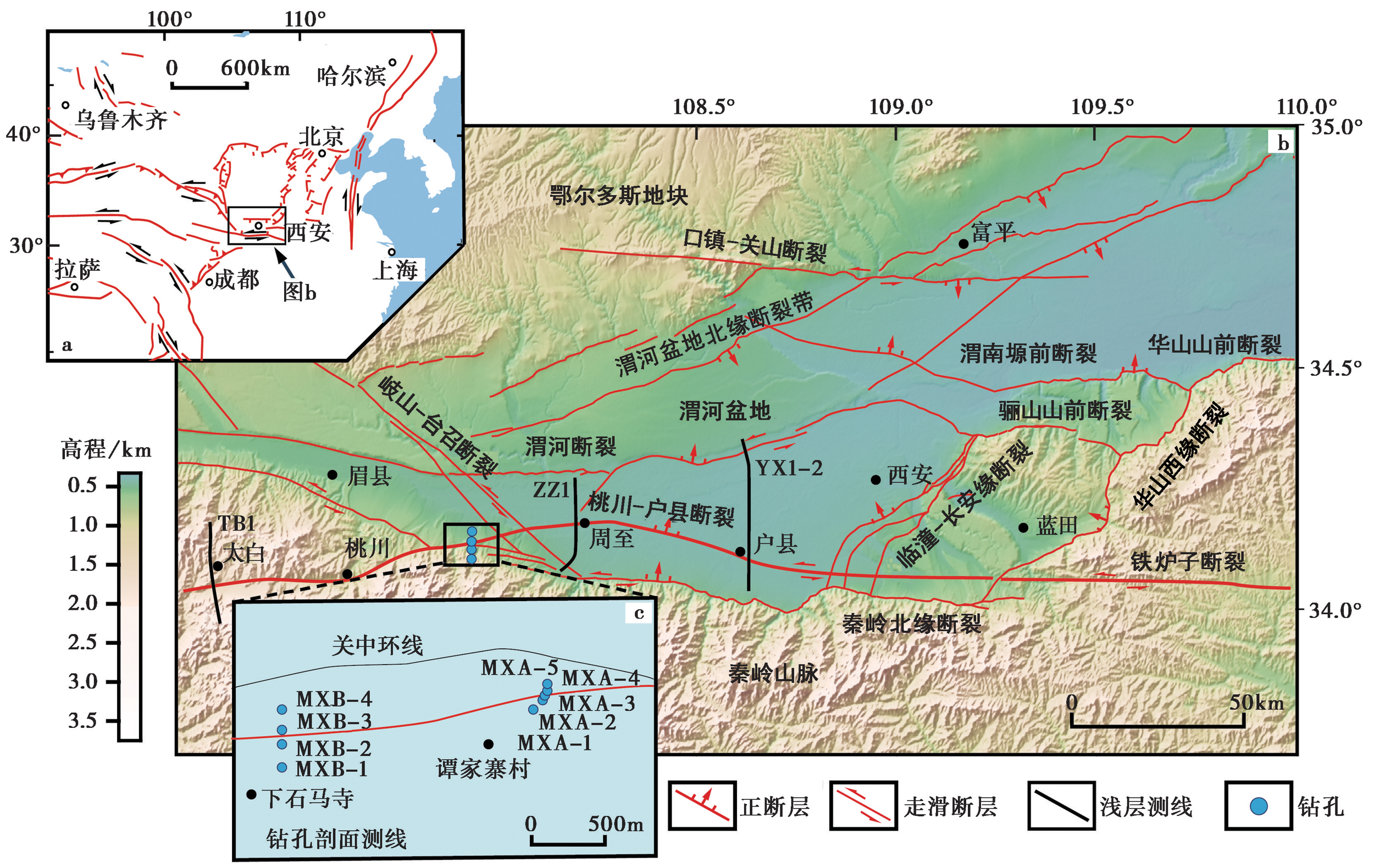
图1 桃川-户县断层的区域构造图与浅层地震勘探测线、钻孔位置
Fig. 1 The sketch map showing the position and tectonic setting of the Taochuan-Huxian Fault, location of shallow seismic reflection lines and drilling joint profile.
| 测线 | 断层 编号 | 实测上断点位置 | 断距 /m | 断层性质 | 视倾向 | 视倾角 | 上断点埋深及 影响的最新地层 | |||||||
|---|---|---|---|---|---|---|---|---|---|---|---|---|---|---|
| 北纬 | 东经 | |||||||||||||
| TB1 | F8 | 107°18'43.79″ | 34°02'04.32″ | >300 | 正断 | N | 65°~75° | 80m, | ||||||
| F15 | 107°18'43.73″ | 34°02'16.38″ | 7 | 逆断 | N | 23°~86° | 71m以浅, | |||||||
| df19 | 107°18'38.94″ | 34°02'29.618″ | 83 | 正断 | N | 89° | 160m, | |||||||
| df20 | 107°18'36.38″ | 34°02'39.098″ | 3 | 正断 | N | 78° | 194m, | |||||||
| df21 | 107°18'35.94″ | 34°02'41.80″ | 9 | 逆断 | N | 67°~89° | 50m以浅, | |||||||
| ZZ1 | F8 | 108°11'36.28″ | 34°08'56.25″ | 19 | 正断 | N | 51°~60° | 127m以浅, | ||||||
| df24 | 108°12'08.42″ | 34°10'22.93″ | 11 | 正断 | N | 59° | 65m以浅, | |||||||
| df25 | 108°12'11.93″ | 34°10'52.30″ | 11 | 正断 | S | 65° | 76m以浅, | |||||||
| df26 | 108°12'11.92″ | 34°11'12.05″ | 14 | 正断 | S | 71° | 91m以浅, | |||||||
| df27 | 108°12'13.23″ | 34°11'48.09″ | 4 | 正断 | S | 54°~64° | 109m以浅, | |||||||
| YX1-2 | df53 | 108°37'48.60″ | 34°06'05.31″ | 6 | 正断 | N | 74° | 65m以浅, | ||||||
| df54 | 108°37'48.03″ | 34°06'29.96″ | 4 | 正断 | N | 57°~73° | 62m以浅, | |||||||
| F8 | 108°37'47.69″ | 34°06'44.68″ | 11 | 正断 | N | 54°~66° | 52m以浅, | |||||||
表1 3条浅层地震剖面解释的上断点位置及其参数表
Table1 Fault location interpreted by three shallow seismic reflection profiles and up-breakpoint parameters
| 测线 | 断层 编号 | 实测上断点位置 | 断距 /m | 断层性质 | 视倾向 | 视倾角 | 上断点埋深及 影响的最新地层 | |||||||
|---|---|---|---|---|---|---|---|---|---|---|---|---|---|---|
| 北纬 | 东经 | |||||||||||||
| TB1 | F8 | 107°18'43.79″ | 34°02'04.32″ | >300 | 正断 | N | 65°~75° | 80m, | ||||||
| F15 | 107°18'43.73″ | 34°02'16.38″ | 7 | 逆断 | N | 23°~86° | 71m以浅, | |||||||
| df19 | 107°18'38.94″ | 34°02'29.618″ | 83 | 正断 | N | 89° | 160m, | |||||||
| df20 | 107°18'36.38″ | 34°02'39.098″ | 3 | 正断 | N | 78° | 194m, | |||||||
| df21 | 107°18'35.94″ | 34°02'41.80″ | 9 | 逆断 | N | 67°~89° | 50m以浅, | |||||||
| ZZ1 | F8 | 108°11'36.28″ | 34°08'56.25″ | 19 | 正断 | N | 51°~60° | 127m以浅, | ||||||
| df24 | 108°12'08.42″ | 34°10'22.93″ | 11 | 正断 | N | 59° | 65m以浅, | |||||||
| df25 | 108°12'11.93″ | 34°10'52.30″ | 11 | 正断 | S | 65° | 76m以浅, | |||||||
| df26 | 108°12'11.92″ | 34°11'12.05″ | 14 | 正断 | S | 71° | 91m以浅, | |||||||
| df27 | 108°12'13.23″ | 34°11'48.09″ | 4 | 正断 | S | 54°~64° | 109m以浅, | |||||||
| YX1-2 | df53 | 108°37'48.60″ | 34°06'05.31″ | 6 | 正断 | N | 74° | 65m以浅, | ||||||
| df54 | 108°37'48.03″ | 34°06'29.96″ | 4 | 正断 | N | 57°~73° | 62m以浅, | |||||||
| F8 | 108°37'47.69″ | 34°06'44.68″ | 11 | 正断 | N | 54°~66° | 52m以浅, | |||||||
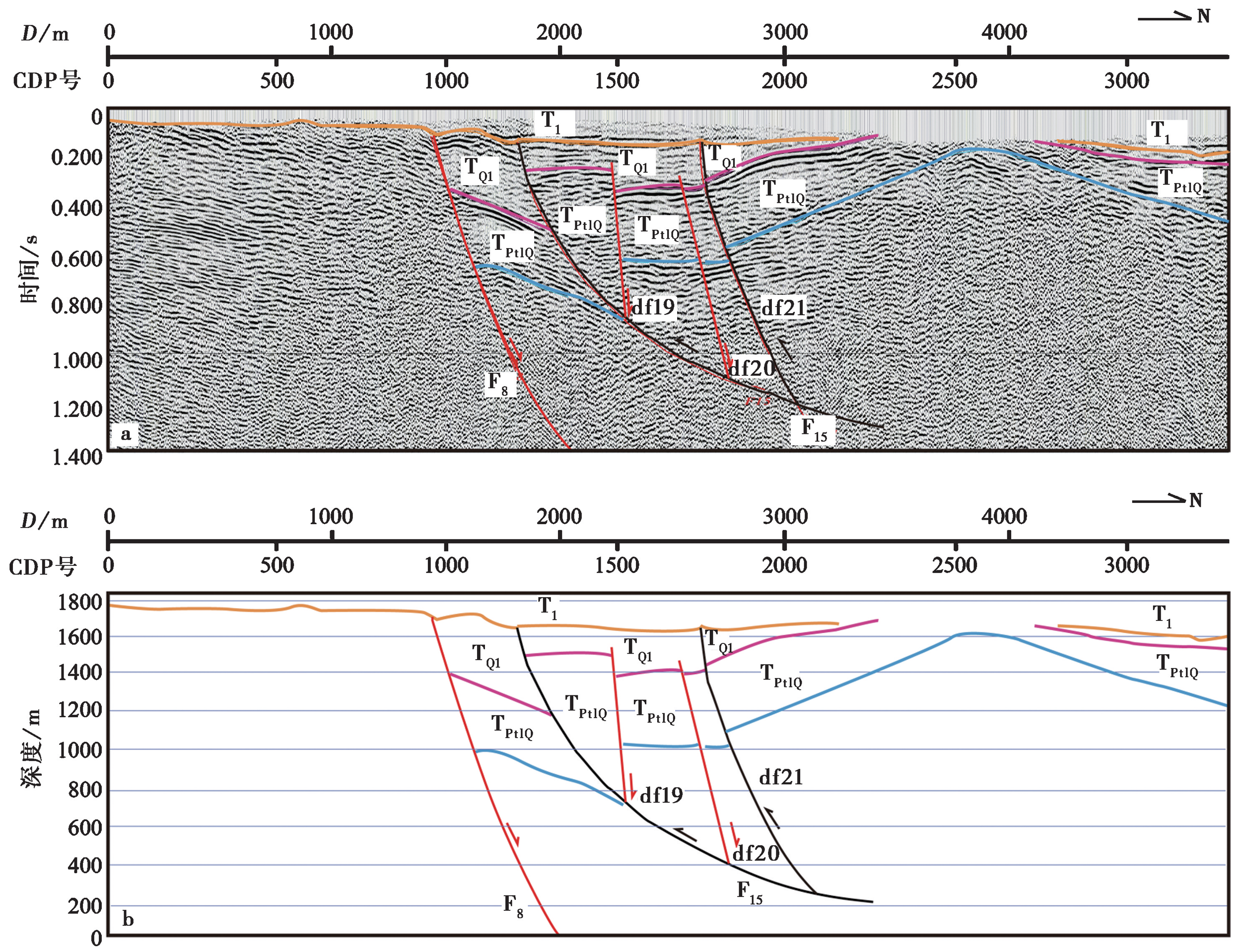
图2 TB1测线的时间剖面图(a)和深度解释剖面图(b) 正断层与运动箭头为红色线条, 逆断层与运动箭头为黑色线条
Fig. 2 Stacked time section(a) and depth interpretation(b) of shallow seismic survey line TB1.
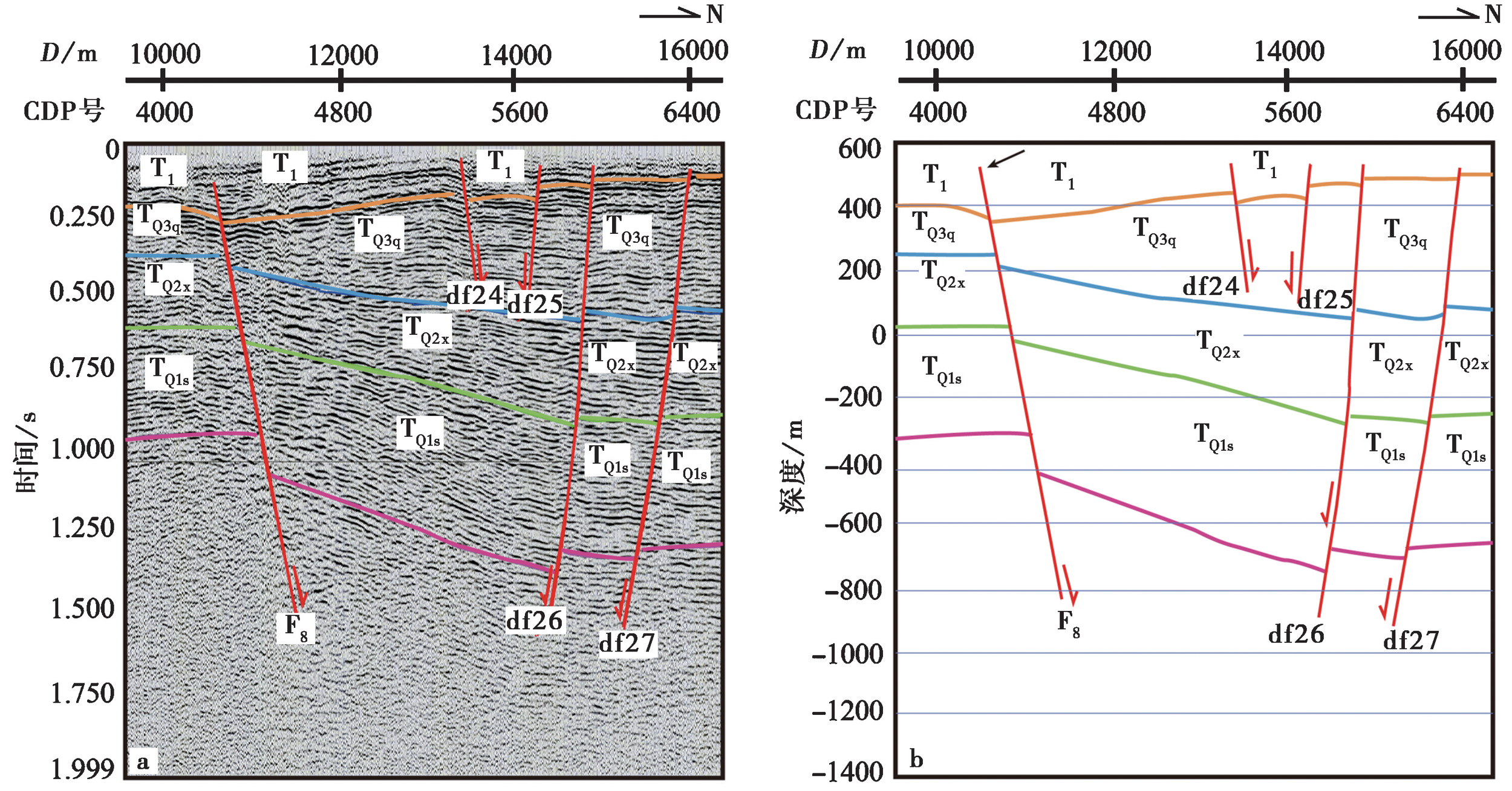
图3 ZZ1测线时间剖面图(a)和深度解释剖面图(b)
Fig. 3 Stacked time section(a) and depth interpretation(b) of shallow seismic survey line ZZ1.
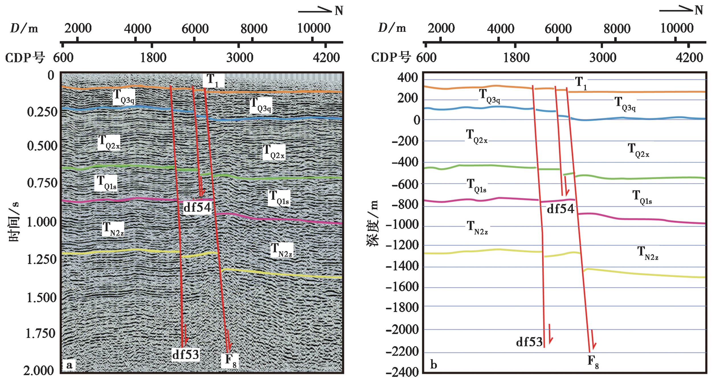
图4 YX1-2测线时间剖面图(a)和深度解释剖面图(b)
Fig. 4 Stacked time section(a)and depth interpretation(b)of shallow seismic survey line YX1-2.
| 剖面 编号 | 标志层 | 垂直活动速率 /mm·a-1 | |||||||||
|---|---|---|---|---|---|---|---|---|---|---|---|
| 编号 | 岩性 | 顶/底界 | 下盘标高 /m | 上盘标高 /m | 地层高差 /m | 错距 /m | 年龄 /ka | ||||
| 谭家寨 剖面 | ② | 黄土状土 | 顶界 | 441.62 | 439.14 | 2.48 | |||||
| ③ | 黑垆土S0 | 顶界 | 436.12 | 431.94 | 4.18 | 4~4.5 | 4~7 | 0.4~1.1 | |||
| 底界 | 433.32 | 428.94 | 4.38 | 10 | |||||||
⑤ | 粉砂黏土 | 顶界 | 403.52 | 397.64 | 5.88 | ||||||
| 底界 | 395.22 | 386.14 | 9.08 | ||||||||
| 下石马寺 剖面 | ② | 黄土状土 | 顶界 | 455.56 | 451.17 | 4.39 | |||||
③ | 黑垆土S0 | 顶界 | 447.76 | 443.27 | 4.49 | 4~5 | 4~7 | 0.4~1.3 | |||
| 底界 | 447.06 | 442.57 | 4.49 | 10 | |||||||
| ⑤ | 卵石 | 顶界 | 445.56 | 440.37 | 5.19 | ||||||
表2 钻孔联合剖面的标志层及其跨越桃川-户县断层的断距信息
Table2 Fault displacements of the Taochuan-Huxian Fault revealed by drilling joint profile exploration
| 剖面 编号 | 标志层 | 垂直活动速率 /mm·a-1 | |||||||||
|---|---|---|---|---|---|---|---|---|---|---|---|
| 编号 | 岩性 | 顶/底界 | 下盘标高 /m | 上盘标高 /m | 地层高差 /m | 错距 /m | 年龄 /ka | ||||
| 谭家寨 剖面 | ② | 黄土状土 | 顶界 | 441.62 | 439.14 | 2.48 | |||||
| ③ | 黑垆土S0 | 顶界 | 436.12 | 431.94 | 4.18 | 4~4.5 | 4~7 | 0.4~1.1 | |||
| 底界 | 433.32 | 428.94 | 4.38 | 10 | |||||||
⑤ | 粉砂黏土 | 顶界 | 403.52 | 397.64 | 5.88 | ||||||
| 底界 | 395.22 | 386.14 | 9.08 | ||||||||
| 下石马寺 剖面 | ② | 黄土状土 | 顶界 | 455.56 | 451.17 | 4.39 | |||||
③ | 黑垆土S0 | 顶界 | 447.76 | 443.27 | 4.49 | 4~5 | 4~7 | 0.4~1.3 | |||
| 底界 | 447.06 | 442.57 | 4.49 | 10 | |||||||
| ⑤ | 卵石 | 顶界 | 445.56 | 440.37 | 5.19 | ||||||
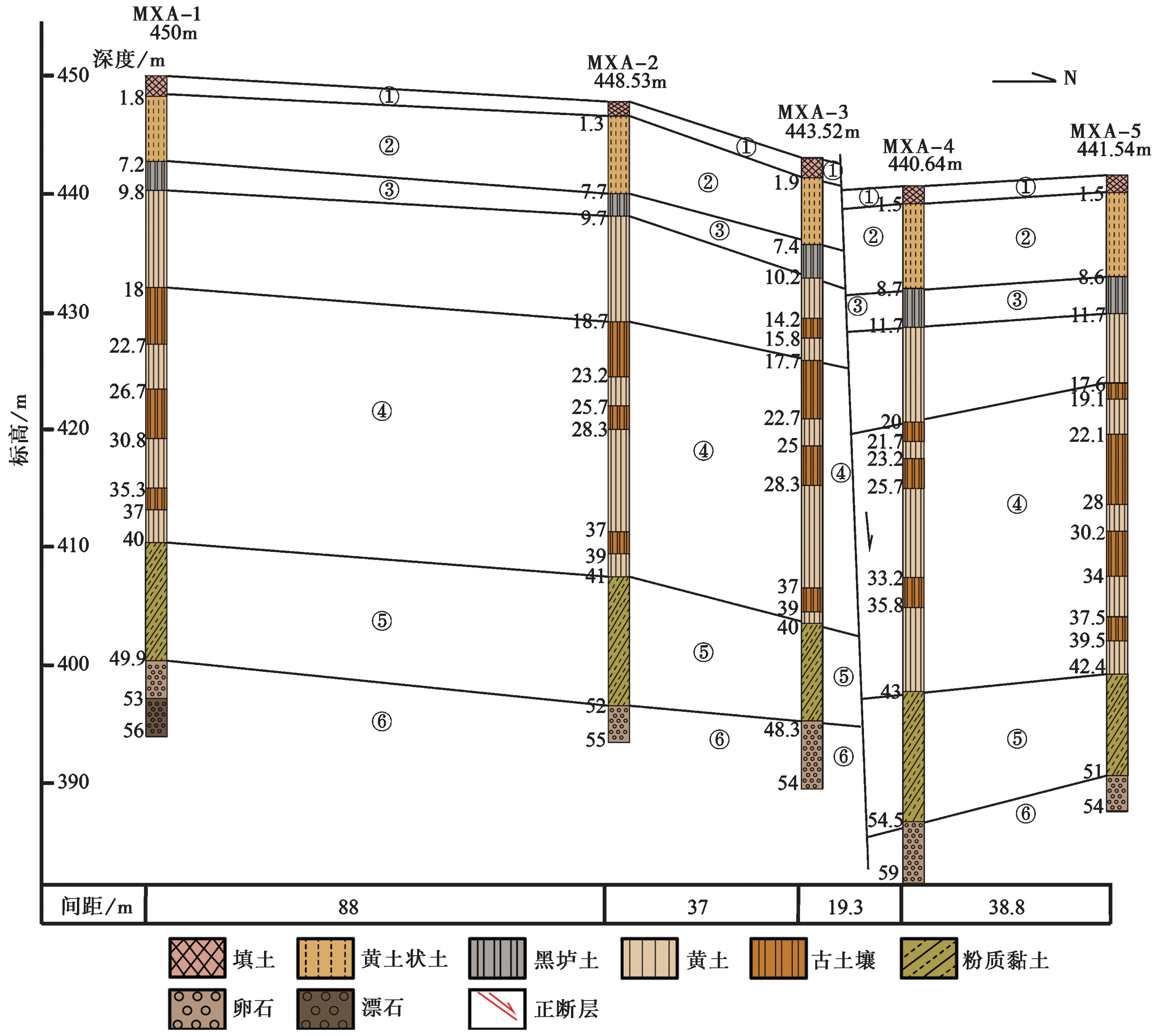
图5 谭家寨钻孔的联合地质剖面图
Fig. 5 Composite drilling geological section in Tanjiazhai.
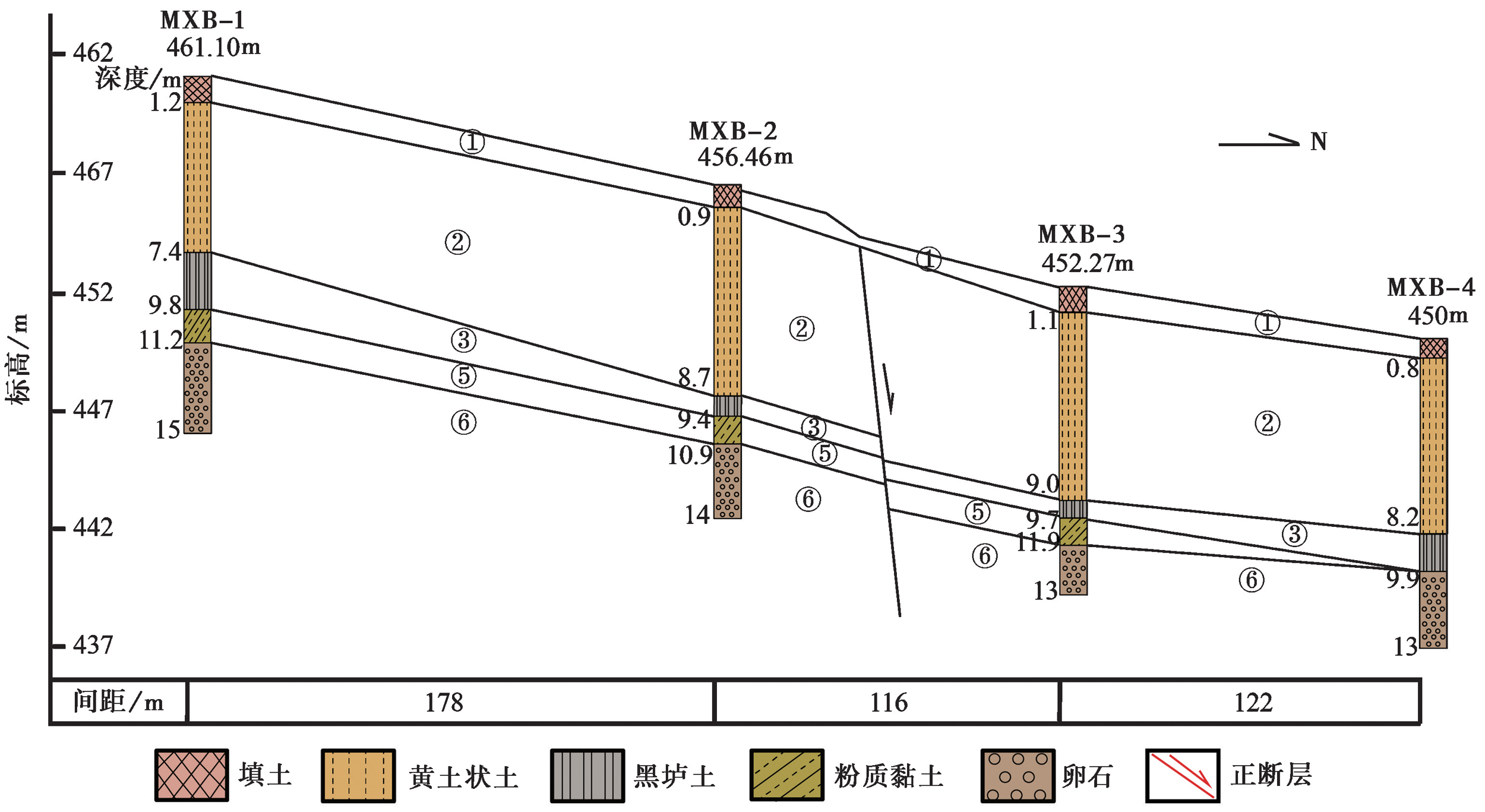
图6 下石马寺钻孔的联合地质剖面图
Fig. 6 Composite drilling geological section in Xiamashisi.
| [1] | 白相东. 2019. 秦岭北缘断裂带活动性对地质灾害影响研究[D]. 哈尔滨: 中国地震局工程力学研究所. |
| BAI Xiang-dong. 2019. Influence study from the activity of the northern margin fault zone of Qinling Mountains on geological hazard[D]. Institute of Engineering Mechanics, China Earthquake Administration, Harbin. (in Chinese) | |
| [2] | 邓起东, 徐锡伟, 张先康, 等. 2003a. 城市活动断裂探测的方法和技术[J]. 地学前缘, 10(1): 93-104. |
| DENG Qi-dong, XU Xi-wei, ZHANG Xian-kang, et al. 2003a. Methods and techniques for surveying and prospecting active faults in urban areas[J]. Earth Science Frontiers, 10(1): 93-104. (in Chinese) | |
| [3] | 邓起东, 张培震, 冉勇康, 等. 2003b. 中国活动构造与地震活动[J]. 地学前缘, 10(S1): 66-73. |
| DENG Qi-dong, ZHANG Pei-zhen, RAN Yong-kang, et al. 2003b. Active tectonics and earthquake activities in China[J]. Earth Science Frontiers, 10(S1): 66-73. (in Chinese) | |
| [4] | 董云鹏, 赖绍聪, 第五春荣, 等. 2021. 中国大陆“十字构造带”关键科学问题研究进展[J]. 西北大学学报(自然科学版), 51(6): 935-950. |
| DONG Yun-peng, LAI Shao-cong, DIWU Chun-rong, et al. 2021. Research progress on key scientific issues of “Cross-Tectonics”in China continent[J]. Journal of Northwest University(Natural Science Edition), 51(6): 935-950. (in Chinese) | |
| [5] | 方盛明, 张先康, 刘保金, 等. 2006. 城市活断层地震勘探的最佳组合方法与应用研究[J]. 地震地质, 28(4): 646-654. |
| FANG Sheng-ming, ZHANG Xian-kang, LIU Bao-jin, et al. 2006. The best combination methods and applied research of seismic prospecting for active faults in urban area[J]. Seismology and Geology, 28(4): 646-654. (in Chinese) | |
| [6] |
顾勤平, 许汉刚, 晏云翔, 等. 2020. 郯庐断裂带新沂段地壳浅部结构和断裂活动性探测[J]. 地震地质, 42(4): 825-843. doi: 10.3969/j.issn.0253-4967.2020.04.004.
DOI |
| GU Qin-ping, XU Han-gang, YAN Yun-xiang, et al. 2020. The crustal shallow structures and fault activity detection in Xinyi section of Tan-Lu fault zone[J]. Seismology and Geology, 42(4): 825-843. (in Chinese) | |
| [7] | 黄伟亮, 杨虔灏, 吕艳, 等. 2020. 秦岭北麓古滑坡分布特征与地震活动关系研究[J]. 工程地质学报, 28(6): 1259-1271. |
| HUANG Wei-liang, YANG Qian-hao, LÜ Yan, et al. 2020. Relationship between distribution characteristics of prehistoric landslides and seismic activity along Qinling piedmont fault[J]. Journal of Engineering Geology, 28(6): 1259-1271. (in Chinese) | |
| [8] |
雷启云, 柴炽章, 郑文俊, 等. 2014. 钻探揭示的黄河断裂北段活动性和滑动速率[J]. 地震地质, 36(2): 464-477. doi: 10.3969/j.issn.0253-4967.2014.02.015.
DOI |
| LEI Qi-yun, CHAI Chi-zhang, ZHENG Wen-jun, et al. 2014. Activity and slip rate of the northern section of Yellow River Fault revealed by drilling[J]. Seismology and Geology, 36(2): 464-477. (in Chinese) | |
| [9] | 雷祥义, 岳乐平. 1997. 陕西关中晚更新世黄土-古土壤序列特征及其记录的古环境变迁[J]. 地质论评, 43(5): 555-560. |
| LEI Xiang-yi, YUE Le-ping. 1997. The characteristics of the late Pleistocene loess-paleosol sequence and their records of paleoenvironmental changes in Guanzhong, Shaanxi[J]. Geological Review, 43(5): 555-560. (in Chinese) | |
| [10] | 刘保金, 柴炽章, 酆少英, 等. 2008. 第四纪沉积区断层及其上断点探测的地震方法技术: 以银川隐伏活动断层为例[J]. 地球物理学报, 51(5): 1475-1483. |
| LIU Bao-jin, CHAI Chi-zhang, FENG Shao-ying, et al. 2008. Seismic exploration method for buried fault and its up-breakpoint in Quaternary sediment area: An example of Yinchuan buried active fault[J]. Chinese Journal of Geophysics, 51(5): 1475-1483. (in Chinese) | |
| [11] | 刘东生. 1997. 第四纪环境[M]. 北京: 科学出版社. |
| LIU Tung-sheng. 1997. Quaternary Environment[M]. Science Press, Beijing. (in Chinese) | |
| [12] |
马冀, 冯希杰, 李高阳, 等. 2016. 1556年华县地震地表破裂带同震垂直位移[J]. 地震地质, 38(1): 22-30. doi: 10.3969/j.issn.0253-4967.2016.01.002.
DOI |
| MA Ji, FENG Xi-jie, LI Gao-yang, et al. 2016. The coseismic vertical displacement of surface rupture zone of the 1556 Huaxian earthquake[J]. Seismology and Geology, 38(1): 22-30. (in Chinese) | |
| [13] | 马丽芳. 2002. 中国地质图集[CM]. 北京: 地质出版社. |
| MA Li-fang. 2002. Geological Atlas of China[CM]. Geological Publishing House, Beijing. (in Chinese) | |
| [14] | 孟庆任. 2017. 秦岭的由来[J]. 中国科学(D辑), 47(4): 412-420. |
|
MENG Qing-ren. 2017. Origin of the Qinling Mountains[J]. Science in China(Ser D), 47(4): 412-420. (in Chinese)
DOI URL |
|
| [15] | 彭建兵, 张骏, 苏生瑞, 等. 1992. 渭河盆地活动断裂与地质灾害[M]. 西安: 西北大学出版社. |
| PENG Jian-bing, ZHANG Jun, SU Sheng-rui, et al. 1992. Active Faults and Geological Hazards in Weihe Basin[M]. Northwestern University Press, Xi'an. (in Chinese) | |
| [16] | 瞿伟, 王运生, 张勤, 等. 2016. 空间大地测量GPS揭示的汾渭盆地及其邻域现今地壳应变场变化特征[J]. 地球物理学报, 59(3): 828-839. |
| QU Wei, WANG Yun-sheng, ZHANG Qin, et al. 2016. Current crustal deformation variation characteristics of the Fenwei Basin and its surrounding areas revealed by GPS data[J]. Chinese Journal of Geophysics, 59(3): 828-839. (in Chinese) | |
| [17] | 任隽, 冯希杰, 王夫运, 等. 2013. 深地震反射剖面揭示的渭河盆地西安坳陷的地壳精细结[J]. 地球物理学报, 56(2): 513-521. |
| REN Jun, FENG Xi-jie, WANG Fu-yun, et al. 2013. Fine crust structures of Xi'an sag in the Weihe Basin revealed by a deep seismic reflection profile[J]. Chinese Journal of Geophysics, 56(2): 513-521. (in Chinese) | |
| [18] | 陕西省地震局. 1996. 秦岭北缘活动断裂带[M]. 北京: 地震出版社. |
| Shaanxi Earthquake Agency. 1996. Active Fault Zone on the Northern Margin of Qining Mountains[M]. Seismological Press, Beijing. (in Chinese) | |
| [19] | 申屠炳明, 宋方敏, 曹忠权, 等. 1991. 秦岭北麓晚第四纪断层陡坎的初步研究[J]. 地震地质, 13(1): 15-25. |
| SHENTU Bing-ming, SONG Fang-min, CAO Zhong-quan, et al. 1991. Preliminary study on late Quaternary fault scarps on the northern piedmont of Qinling Mountains[J]. Seismology and Geology, 13(1): 15-25. (in Chinese) | |
| [20] | 司芗, 滕吉文, 刘有山, 等. 2016. 秦岭造山带与南北相邻地带远震接收函数与地壳结构[J]. 地球物理学报, 59(4): 1321-1334. |
| SI Xiang, TENG Ji-wen, LIU You-shan, et al. 2016. Crust structure of the Qinling orogenic and the region on its north and south margins from teleseismic receiver function[J]. Chinese Journal of Geophysics, 59(4): 1321-1334. (in Chinese) | |
| [21] | 宋治平, 张国民, 刘杰, 等. 2011. 全球地震目录[M]. 北京: 地震出版社. |
| SONG Zhi-ping, ZHANG Guo-min, LIU Jie, et al. 2011. Global Earthquake Catalog[M]. Seismological Press, Beijing. (in Chinese) | |
| [22] |
徐锡伟, 计凤桔, 于贵华, 等. 2000. 用钻孔地层剖面记录恢复古地震序列: 河北夏垫断裂古地震研究[J]. 地震地质, 22(1): 9-19. doi: 10.3969/j.issn.0253-4967.2000.01.002.
DOI |
| XU Xi-wei, JI Feng-ju, YU Gui-hua, et al. 2000. Reconstruction of paleoearthquake sequence using stratigraphic records from drill logs: A study at the Xiadian Fault, Beijing[J]. Seismology and Geology, 22(1): 9-19. (in Chinese) | |
| [23] |
杨晨艺, 李晓妮, 冯希杰, 等. 2021. 渭河盆地北缘口镇-关山断层的晚第四纪-现今的活动性[J]. 地震地质, 43(3): 504-520. doi: 10.3969/j.issn.0253-4967.2021.03.003.
DOI |
|
YANG Chen-yi, LI Xiao-ni, FENG Xi-jie, et al. 2021. The late Quaternary and present-day activities of the Kouzhen-Guanshan Fault on the northern boundary of Weihe graben basin, China[J]. Seismology and Geology, 43(3): 504-520. doi: 10.3969/j.issn.0253-4967.2021.03.003. (in Chinese)
DOI |
|
| [24] | 杨虔灏. 2022. 基于构造地貌特征研究秦岭北缘断裂地震活动历史[D]. 西安: 长安大学. |
| YANG Qian-hao. 2022. Research on the seismic activity history of faults in the northern margin of Qinling Mountains based on structural geomorphological features[D]. Chang'an University, Xi'an. (in Chinese) | |
| [25] | 杨晓平, 邓起东, 冯希杰. 2005. 东秦岭内部铁炉子断裂带的最新走滑活动[J]. 中国地震, 21(2): 172-183. |
| YANG Xiao-ping, DENG Qi-dong, FENG Xi-jie. 2005. The Tieluzi Fault interior of the eastern Qinling Mountains: An active strike-slip fault[J]. Earthquake Research in China, 21(2): 172-183. (in Chinese) | |
| [26] |
余占洋, 沈旭章, 梁浩, 等. 2022. 基于地震活动性和震源机制解研究渭河-运城盆地主要断裂带的特征及应力场分布[J]. 地震地质, 44(2): 395-413. doi: 10.3969/j.issn.0253-4967.2022.02.008.
DOI |
| YU Zhan-yang, SHEN Xu-zhang, LIANG Hao, et al. 2022. The characteristics of major faults and stress field in Weihe-Yuncheng Basin constrained by seismic activity and focal mechanism solutions[J]. Seismology and Geology, 44(2): 395-413. (in Chinese) | |
| [27] | 原廷宏, 冯希杰, 吕莲, 等. 2010. 一五五六年华县特大地震[M]. 北京: 地震出版社. |
| YUAN Ting-hong, FENG Xi-jie, LÜ Lian, et al. 2010. The 1556 Huaxian Great Earthquake[M]. Seismological Press, Beijing. (in Chinese) | |
| [28] | 张安良, 米丰收, 种瑾. 1989. 1556年陕西华县大地震形变遗迹及华山山前断裂古地震研究[J]. 地震地质, 11(3): 73-81. |
| ZHANG An-liang, MI Feng-shou, CHONG Jin. 1989. Deformation relics of the 1556 Huaxian(Shaanxi, China)great earthquake and the study of palaeoseismicity on the frontal fault zone of the Huashan Mts[J]. Seismology and Geology, 11(3): 73-81. (in Chinese) | |
| [29] |
张恩会, 师亚芹, 张艺, 等. 2021. 桃川-户县断裂渭河盆地隐伏段的展布与结构特征[J]. 地震地质, 43(6): 1485-1506. doi: 10.3969/j.issn.0253-4967.2021.06.008.
DOI |
| ZHANG En-hui, SHI Ya-qin, ZHANG Yi, et al. 2021. Extension and structural feature of the buried segment of Taochuan-Huxian Fault in the Weihe Basin[J]. Seismology and Geology, 43(6): 1485-1506. (in Chinese) | |
| [30] | 张国伟, 郭安林, 董云鹏, 等. 2019. 关于秦岭造山带[J]. 地质力学学报, 25(5): 746-768. |
| ZHANG Guo-wei, GUO An-lin, DONG Yun-peng, et al. 2019. Rethinking of the Qinling Orogen[J]. Journal of Geomechanics, 25(5): 746-768. (in Chinese) | |
| [31] | 张国伟, 张本仁, 袁学诚, 等. 2001. 秦岭造山带与大陆动力学[M]. 北京: 科学出版社. |
| ZHANG Guo-wei, ZHANG Ben-ren, YUAN Xue-cheng, et al. 2001. Qinling Orogenic Belt and Continental Dynamics[M]. Science Press, Beijing. (in Chinese) | |
| [32] | 张培震, 邓起东, 张国民, 等. 2003. 中国大陆的强震活动与活动地块[J]. 中国科学(D辑), 33(S1): 12-20. |
| ZHANG Pei-zhen, DENG Qi-dong, ZHANG Guo-min, et al. 2003. Active tectonic blocks and strong earthquakes in the continent of China[J]. Science in China(Ser D), 33(S1): 12-20. (in Chinese) | |
| [33] | 张培震, 郑德文, 尹功明, 等. 2006. 有关青藏高原东北缘晚新生代扩展与隆升的讨论[J]. 第四纪研究, 26(1): 5-13. |
| ZHANG Pei-zhen, ZHENG De-wen, YIN Gong-ming, et al. 2006. Discussion on late Cenozoic growth and rise of northeastern margin of the Tibetan plateau[J]. Quaternary Sciences, 26(1): 5-13. (in Chinese) | |
| [34] | 张岳桥, 马寅生, 杨农, 等. 2005. 西秦岭地区东昆仑-秦岭断裂系晚新生代左旋走滑历史及其向东扩展[J]. 地球学报, 26(1): 1-8. |
| ZHANG Yue-qiao, MA Yin-sheng, YANG Nong, et al. 2005. Late Cenozoic left-slip faulting process of the east Kunlun-Qinling fault system in west Qinling region and its eastward propagation[J]. Acta Geoscientica Sinica, 26(1): 1-8. (in Chinese) | |
| [35] | 张岳桥, 施炜, 董树文. 2019. 华北新构造: 印欧碰撞远场效应与太平洋俯冲地幔上涌之间的相互作用[J]. 地质学报, 93(5): 971-1001. |
| ZHANG Yue-qiao, SHI Wei, DONG Shu-wen. 2019. Neotectonics of North China: Interplay between far-field effect of India-Eurasia collision and Pacific subduction related deep-seated mantle upwelling[J]. Acta Geologica Sinica, 93(5): 971-1011. (in Chinese) | |
| [36] | 张岳桥, Vergely P, Mercier J L. 1999. 华北地区上新世至第四纪断裂作用型式与左旋扩展[J]. 地质力学学报, 5(3): 40-46. |
| ZHANG Yue-qiao, Vergely P, Mercier J L. 1999. Pliocene-Quaternary faulting pattern and left-slip propagation tectonics in North China[J]. Journal of Geomechanics, 5(3): 40-46. (in Chinese) | |
| [37] | 赵景波, 童国榜. 1994. 秦岭太白盆地黄土地层发育时的古环境[J]. 西安地质学院学报, 16(1): 64-70. |
| ZHAO Jing-bo, TONG Guo-bang. 1994. Paleoenvironment during development of the loess strata in Taibai Basin of Qinling Mountains[J]. Journal of Xi'an College of Geology, 16(1): 64-70. (in Chinese) | |
| [38] | 中国地震局. 2005. 中国地震活断层探测技术系统技术规程区[M]. 北京: 地震出版社. |
| China Earthquake Administration. 2005. Stipulation on Technical System for China Earthquake Active Fault Surveying[M]. Seismological Press, Beijing. (in Chinese) | |
| [39] |
Dong Y P, Zhang G W, Neubauer F, et al. 2011. Tectonic evolution of the Qinling orogen, China: Review and synthesis[J]. Journal of Asian Earth Sciences, 41(3): 213-237.
DOI URL |
| [40] |
Gu Q P, Kang Q Q, Xu H G, et al. 2018. New evidence from shallow seismic surveys for Quaternary activity of the Benchahe Fault[J]. Journal of Geophysics and Engineering, 15(4): 1528-1541.
DOI URL |
| [41] |
Guo Z, Chen J. 2016. Crustal structure of the eastern Qinling orogenic belt and implication for reactivation since the Cretaceous[J]. Tectonophysics, 683(3): 1-11.
DOI URL |
| [42] |
Kanari M, Niemi T M, Ben-Avraham Z, et al. 2020. Seismic potential of the Dead Sea Fault in the northern Gulf of Aqaba-Elat: New evidence from liquefaction, seismic reflection, and paleoseismic data[J]. Tectonophysics, 793(1): 228596.
DOI URL |
| [43] |
Kukla G, An Z S. 1989. Loess stratigraphy in central China[J]. Palaeogeography Palaeoclimatology Palaeoecology, 72(89): 203-225.
DOI URL |
| [44] |
Li T, Zhang Y, Lu R Q, et al. 2021. 3D geometry of the Lanliao Fault revealed by seismic reflection profiles: Implications for earthquake clustering in the Dongpu Sag, North China[J]. Tectonophysics, 806: 228798.
DOI URL |
| [45] | Li X N, Pierce I, Bormann J M, et al. 2021. Tectonic deformation of the northeastern Tibetan plateau and its surroundings revealed with GPS block modeling[J]. Journal of Geophysical Research: Solid Earth, 126(5): e2020JB020733. |
| [46] |
Liu J H, Zhang P Z, Lease R O, et al. 2013. Eocene onset and late Miocene acceleration of Cenozoic intracontinental extension in the North Qinling Range-Weihe Graben: Insights from apatite fission track thermochronology[J]. Tectonophysics, 584(22): 281-296.
DOI URL |
| [47] |
Molnar P, Tapponnier P. 1975. Cenozoic tectonics of Asia: Effects of a continental collision: Features of recent continental tectonics in Asia can be interpreted as results of the India-Eurasia collision[J]. Science, 189(4201): 419-426.
PMID |
| [48] |
Peltzer G, Tapponnier P, Zhang Z T, et al. 1985. Neogene and Quaternary faulting in and along the Qinling Shan[J]. Nature, 317(6037): 500-505.
DOI |
| [49] | Sun J M. 2005. Long-term fluvial archives in the Fen Wei Graben, Central China, and their bearing on the tectonic history of the India-Asia collision system during the Quaternary[J]. Quaternary Science Reviews, 24(10-11): 1279-1286. |
| [50] |
Zhang A L, Yang Z T, Zhong J, et al. 1995. Characteristics of late Quaternary activity along the southern border fault zone of Weihe Graben Basin[J]. Quaternary International, 25(4): 25-31.
DOI URL |
| [51] |
Zhang Y Q, Mercier J L, Vergely P. 1998. Extension in the graben systems around the Ordos(China), and its contribution to the extrusion tectonics of South China with respect to Gobi-Mongolia[J]. Tectonophysics, 285(1): 41-75.
DOI URL |
| [52] |
Zhou W J, An Z S. 1994. Stratigraphic divisions of the Holocene loess in China[J]. Radiocarbon, 36(1): 37-45.
DOI URL |
| [1] | 黎益仕. 活动断层探测综合标准化[J]. 地震地质, 2023, 45(2): 455-463. |
| [2] | 李晓妮, 杨晨艺, 李高阳, 冯希杰, 黄引弟, 李陈侠, 李苗, 裴跟弟, 王万合. 渭河盆地东南缘渭南塬前北侧分支断层的浅部结构及晚第四纪活动[J]. 地震地质, 2023, 45(2): 484-499. |
| [3] | 张浩, 王金艳, 许汉刚, 李丽梅, 蒋新, 赵启光, 顾勤平. 安丘-莒县断裂新沂段的几何结构特征[J]. 地震地质, 2022, 44(6): 1448-1468. |
| [4] | 曹筠, 李彦宝, 冉勇康, 徐锡伟, 马董伟, 张志强. 城市隐伏活动断层避让典型案例分析--以新沂市郯庐断裂带沿线某场地为例[J]. 地震地质, 2022, 44(4): 1071-1085. |
| [5] | 张恩会, 师亚芹, 张艺, 李苗, 李高阳, 裴跟弟, 王万合. 桃川-户县断裂渭河盆地隐伏段的展布与结构特征[J]. 地震地质, 2021, 43(6): 1485-1506. |
| [6] | 杨晓平, 王萍, 李晓峰, 谢超, 周本刚, 黄雄南. 地形坡度和高程变异系数在识别墨脱活动断裂带中的应用[J]. 地震地质, 2019, 41(2): 419-435. |
| [7] | 吴熙彦, 徐锡伟, 于贵华, 程佳, 陈桂华, 安艳芬, 王启欣. 国家川滇实验场地震地表破裂带分布图编制[J]. 地震地质, 2018, 40(1): 27-41. |
| [8] | 蔡明刚, 鲁人齐, 何宏林, 徐锡伟, 王振南, 李海鸥, 吴熙彦. 水域三维地形与活动断层探测研究——以西昌邛海为例[J]. 地震地质, 2018, 40(1): 204-214. |
| [9] | 闫兵, 贾东. 沿走滑活动断层的基岩河道系统位错——以青藏高原东部为例[J]. 地震地质, 2017, 39(6): 1127-1142. |
| [10] | 邵延秀, 张波, 邹小波, 王爱国, 张帆宇, 袁道阳, 刘兴旺, 何文贵. 采用无人机载LiDAR进行快速地质调查实践[J]. 地震地质, 2017, 39(6): 1185-1197. |
| [11] | 郝海健, 何宏林, 魏占玉, 石峰. 同震地表破裂及活动断层迹线的几何形貌特征[J]. 地震地质, 2017, 39(6): 1267-1282. |
| [12] | 徐锡伟, 郭婷婷, 刘少卓, 于贵华, 陈桂华, 吴熙彦. 活动断层避让相关问题的讨论[J]. 地震地质, 2016, 38(3): 477-502. |
| [13] | 李胜强, 张玲, 杨晓平, 黄伟亮, 黄雄南, 杨海波. 库车坳陷东部秋里塔格背斜带的活动断层及其形成机制[J]. 地震地质, 2016, 38(2): 223-239. |
| [14] | 吴熙彦, 于贵华, 杜克平, 徐锡伟. 活动断层探察的快速制图技术研究[J]. 地震地质, 2016, 38(2): 397-409. |
| [15] | 田勤虎, 周本刚, 李晓妮, 石金虎, 魏青珂, 卞菊梅. 渭河断裂杨家村-窑店段展布及晚第四纪活动特征[J]. 地震地质, 2016, 38(1): 141-151. |
| 阅读次数 | ||||||
|
全文 |
|
|||||
|
摘要 |
|
|||||
