地震地质 ›› 2022, Vol. 44 ›› Issue (1): 98-114.DOI: 10.3969/j.issn.0253-4967.2022.01.007
李占飞1),2),3)( ), 徐锡伟3),*, 孟勇琦2), 赵帅2), 孙佳珺2), 程佳3), 李康3), 康文君3)
收稿日期:2020-12-31
修回日期:2021-08-25
出版日期:2022-02-20
发布日期:2022-04-20
通讯作者:
徐锡伟
作者简介:李占飞, 男, 1989年生, 现为中国地震局地质研究所构造地质学专业在读博士研究生, 工程师, 主要研究方向为活动构造及断层三维建模, 电话: 17710321147, E-mail: lizhanfei@bjseis.gov.cn。
基金资助:
LI Zhan-fei1),2),3)(), XU Xi-wei3),*, MENG Yong-qi2), ZHAO Shuai2), SUN Jia-jun2), CHENG Jia3), LI Kang3), KANG Wen-jun3)
Received:2020-12-31
Revised:2021-08-25
Online:2022-02-20
Published:2022-04-20
Contact:
XU Xi-wei
摘要:
文中利用高分辨率“吉林一号”卫星影像数据, 获得了夏垫断裂沿线高精度DEM数据(1.0m)。基于高精度地形数据对夏垫断裂开展了定量研究, 揭示出1679年三河-平谷地震地表破裂由5条大致呈左阶平行展布的、 长约3km的分支断层组成, 地表破裂的总长度约为12.3km。位错测量揭示出断裂垂直位移沿断层呈不对称三角形分布, 存在2个明显波峰。断裂沿线的平均位移值为1.8m, 约3.2m的最大位移值分布在潘各庄附近。位错模拟分析表明, 其可能代表了2次地震事件的累积位错。根据夏垫断裂上代表华北地区最新构造变形的地表破裂带相关定量参数估算的震级(约 MW6.3 或 MS6.25 ), 与1679年三河-平谷地震的历史震级(约M8.0或 MS8.0 )存在较大差异。这可能与华北地区现今剪切走滑构造变形与早期分布于上地壳的断陷拉张构造在孕震层存在的解耦作用, 或华北地区巨厚的第四纪覆盖层对构造变形的吸收作用相关, 这种假设也被浅层地震反射剖面揭示的断层切割关系和现今走滑型的震源机制所印证。
中图分类号:
李占飞, 徐锡伟, 孟勇琦, 赵帅, 孙佳珺, 程佳, 李康, 康文君. 基于“吉林一号”高精度遥感数据研究华北地区最新构造变形样式——以夏垫断裂1679年三河-平谷地震地表破裂为例[J]. 地震地质, 2022, 44(1): 98-114.
LI Zhan-fei, XU Xi-wei, MENG Yong-qi, ZHAO Shuai, SUN Jia-jun, CHENG Jia, LI Kang, KANG Wen-jun. THE LATEST DEFORMATION STYLE ALONG THE NORTH CHINA BLOCK REVEALED BY HIGH-RESOLUTION TOPOGRAPHIC DATA: A CASE STUDY ON XIADIAN FAULT[J]. SEISMOLOGY AND GEOLOGY, 2022, 44(1): 98-114.
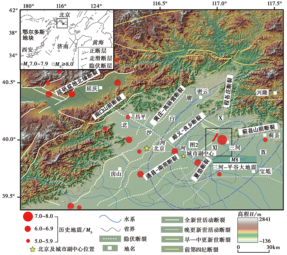
图 1 北京地区活动断裂及历史地震分布
Fig. 1 Distribution of active faults and historical earthquakes in Beijing area.
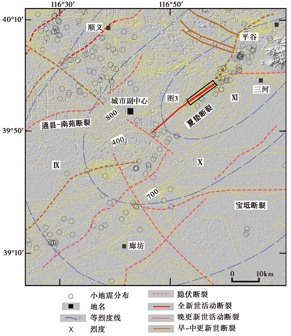
图 2 夏垫断裂及周缘的活动构造图
Fig. 2 Active tectonics map around the Xiadian Fault.
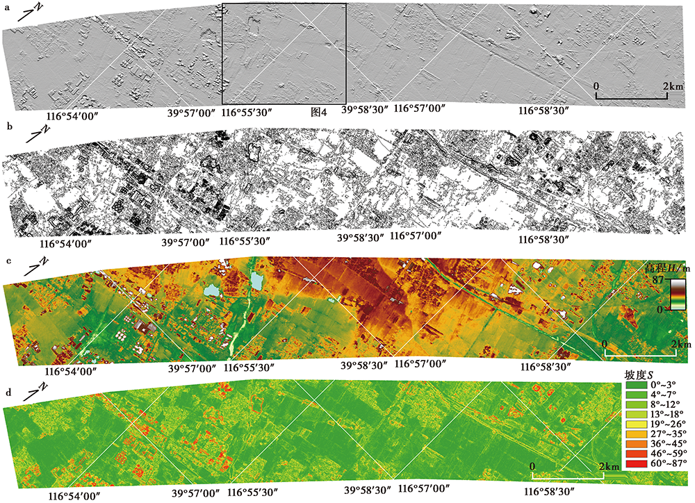
图 3 研究获得的高精度数据及其在GIS平台的分析 a 山影图; b 1m等高线图; c 高程分布图; d 坡度图
Fig. 3 High-resolution DEM and the analysis on GIS platform.
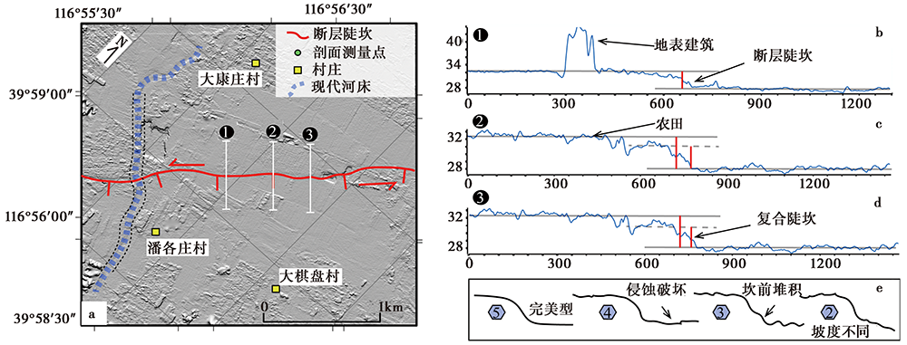
图 4 潘各庄附近典型地形a剖面的位错测量 a 潘各庄附近地形剖面测线的分布; b—d 通过地形剖面测量获得的断层位错值及复合陡坎分布;e 不同确信度值代表的剖面形态
Fig. 4 Fault scarp measurements near Pangezhuang village.
| 编号 | 纬度 | 经度 | 位移值/m | 误差/m | 距离/m | 确信度 |
|---|---|---|---|---|---|---|
| 0 | 39°56'7.865″N | 116°53'11.381″E | 0.71 | 0.12 | 0.00 | 2 |
| 1 | 39°56'17.207″N | 116°53'16.538″E | 1.25 | 0.21 | 312.06 | 2 |
| 2 | 39°56'25.711″N | 116°53'23.051″E | 1.28 | 0.13 | 617.31 | 2 |
| 4 | 39°56'38.515″N | 116°53'39.880″E | 1.45 | 0.12 | 1183.30 | 1 |
| 5 | 39°56'41.436″N | 116°53'49.519″E | 1.75 | 0.23 | 1431.16 | 4 |
| 6 | 39°56'46.029″N | 116°53'57.489″E | 1.78 | 0.11 | 1666.28 | 3 |
| 7 | 39°56'52.957″N | 116°54'1.995″E | 1.94 | 0.15 | 1905.16 | 4 |
| *8-1 | 39°56'57.440″N | 116°54'12.577″E | 1.20 | 0.13 | 2190.14 | 2 |
| 8 | 39°56'57.440″N | 116°54'12.577″E | 2.25 | 0.37 | 2190.14 | 2 |
| 9 | 39°57'3.791″N | 116°54'19.172″E | 2.45 | 0.13 | 2440.44 | 2 |
| 10 | 39°57'10.881″N | 116°54'25.114″E | 2.21 | 0.23 | 2701.44 | 2 |
| *11-1 | 39°57'17.456″N | 116°54'30.418″E | 1.20 | 0.10 | 2939.88 | 3 |
| 11 | 39°57'17.456″N | 116°54'30.418E | 2.08 | 0.18 | 2939.88 | 3 |
| 12 | 39°57'23.190″N | 116°54'38.980″E | 2.17 | 0.12 | 3208.88 | 3 |
| 13 | 39°57'30.981″N | 116°54'44.087″E | 1.90 | 0.17 | 3479.29 | 3 |
| 14 | 39°57'38.760″N | 116°54' 49.957″E | 1.62 | 0.12 | 3769.88 | 3 |
| 15 | 39°57'45.249″N | 116°54'55.848″E | 2.24 | 0.19 | 4015.88 | 3 |
| 16 | 39°57'51.248″N | 116°55'3.132″E | 1.98 | 0.10 | 4275.88 | 4 |
| 17 | 39°57'58.290″N | 116°55'9.927″E | 1.47 | 0.19 | 4545.88 | 4 |
| 18 | 39°58'4.988″N | 116°55'16.946″E | 2.00 | 0.15 | 4811.88 | 3 |
| 19 | 39°58'9.371″N | 116°55'26.199″E | 2.05 | 0.12 | 5071.88 | 4 |
| *20-1 | 39°58'14.525″N | 116°55'32.997″E | 1.30 | 0.20 | 5297.88 | 4 |
| 20 | 39°58'14.525″N | 116°55'32.997″E | 2.42 | 0.22 | 5297.88 | 4 |
| 21 | 39°58'19.746″N | 116°55'40.657″E | 2.89 | 0.20 | 5542.88 | 5 |
| 22 | 39°58'25.375″N | 116°55'49.789″E | 3.20 | 0.30 | 5822.88 | 5 |
| *23-1 | 39°58'32.529″N | 116°55'57.400″E | 1.56 | 0.20 | 6105.88 | 5 |
| 23 | 39°58'32.529″N | 116°55'57.400″E | 2.67 | 0.20 | 6105.88 | 5 |
| 24 | 39°58'39.348″N | 116°56'8.108″E | 2.24 | 0.19 | 6439.88 | 2 |
| *25-1 | 39°58'39.348″N | 116°56'8.108″E | 1.07 | 0.20 | 6929.88 | 2 |
| 25 | 39°58'47.433″N | 116°56'26.066″E | 1.92 | 0.13 | 6929.88 | 2 |
| 26 | 39°58'54.415″N | 116°56'33.329″E | 1.80 | 0.18 | 7206.88 | 3 |
| 28 | 39°59'7.057″N | 116°56'48.822″E | 1.72 | 0.28 | 7744.88 | 2 |
| 29 | 39°59'13.481″N | 116°56'58.094″E | 1.64 | 0.13 | 8039.88 | 2 |
| 31 | 39°59'27.196″N | 116°57'24.771″E | 1.65 | 0.19 | 8804.88 | 3 |
| 32 | 39°59'35.520″N | 116°57'32.329″E | 1.44 | 0.12 | 9122.88 | 3 |
| 33 | 39°59'43.783″N | 116°57'40.395″E | 1.60 | 0.18 | 9440.88 | 3 |
| 34 | 39°59'52.152″N | 116°57'49.536″E | 1.40 | 0.14 | 9773.88 | 3 |
| 35 | 39°59'59.124″N | 116°57'57.855″E | 1.75 | 0.33 | 10066.88 | 2 |
| 36 | 40°0'5.833″N | 116°58'7.526″E | 1.37 | 0.17 | 10372.88 | 2 |
| 37 | 40°0'13.136″N | 116°58'17.105″E | 1.14 | 0.19 | 10691.88 | 4 |
| 38 | 40°0'20.450″N | 116°58'27.188″E | 0.97 | 0.13 | 11018.88 | 3 |
| 39 | 40°0'27.675″N | 116°58'36.895″E | 1.02 | 0.12 | 11338.88 | 3 |
| 40 | 40°0'34.669″N | 116°58'46.996″E | 1.27 | 0.1 | 11664.88 | 2 |
| 41 | 40°0'41.872″N | 116°58'57.548″E | 1.25 | 0.19 | 12007.88 | 2 |
表1 测量获得的位错值
Table 1 Measured vertical offsets along the fault
| 编号 | 纬度 | 经度 | 位移值/m | 误差/m | 距离/m | 确信度 |
|---|---|---|---|---|---|---|
| 0 | 39°56'7.865″N | 116°53'11.381″E | 0.71 | 0.12 | 0.00 | 2 |
| 1 | 39°56'17.207″N | 116°53'16.538″E | 1.25 | 0.21 | 312.06 | 2 |
| 2 | 39°56'25.711″N | 116°53'23.051″E | 1.28 | 0.13 | 617.31 | 2 |
| 4 | 39°56'38.515″N | 116°53'39.880″E | 1.45 | 0.12 | 1183.30 | 1 |
| 5 | 39°56'41.436″N | 116°53'49.519″E | 1.75 | 0.23 | 1431.16 | 4 |
| 6 | 39°56'46.029″N | 116°53'57.489″E | 1.78 | 0.11 | 1666.28 | 3 |
| 7 | 39°56'52.957″N | 116°54'1.995″E | 1.94 | 0.15 | 1905.16 | 4 |
| *8-1 | 39°56'57.440″N | 116°54'12.577″E | 1.20 | 0.13 | 2190.14 | 2 |
| 8 | 39°56'57.440″N | 116°54'12.577″E | 2.25 | 0.37 | 2190.14 | 2 |
| 9 | 39°57'3.791″N | 116°54'19.172″E | 2.45 | 0.13 | 2440.44 | 2 |
| 10 | 39°57'10.881″N | 116°54'25.114″E | 2.21 | 0.23 | 2701.44 | 2 |
| *11-1 | 39°57'17.456″N | 116°54'30.418″E | 1.20 | 0.10 | 2939.88 | 3 |
| 11 | 39°57'17.456″N | 116°54'30.418E | 2.08 | 0.18 | 2939.88 | 3 |
| 12 | 39°57'23.190″N | 116°54'38.980″E | 2.17 | 0.12 | 3208.88 | 3 |
| 13 | 39°57'30.981″N | 116°54'44.087″E | 1.90 | 0.17 | 3479.29 | 3 |
| 14 | 39°57'38.760″N | 116°54' 49.957″E | 1.62 | 0.12 | 3769.88 | 3 |
| 15 | 39°57'45.249″N | 116°54'55.848″E | 2.24 | 0.19 | 4015.88 | 3 |
| 16 | 39°57'51.248″N | 116°55'3.132″E | 1.98 | 0.10 | 4275.88 | 4 |
| 17 | 39°57'58.290″N | 116°55'9.927″E | 1.47 | 0.19 | 4545.88 | 4 |
| 18 | 39°58'4.988″N | 116°55'16.946″E | 2.00 | 0.15 | 4811.88 | 3 |
| 19 | 39°58'9.371″N | 116°55'26.199″E | 2.05 | 0.12 | 5071.88 | 4 |
| *20-1 | 39°58'14.525″N | 116°55'32.997″E | 1.30 | 0.20 | 5297.88 | 4 |
| 20 | 39°58'14.525″N | 116°55'32.997″E | 2.42 | 0.22 | 5297.88 | 4 |
| 21 | 39°58'19.746″N | 116°55'40.657″E | 2.89 | 0.20 | 5542.88 | 5 |
| 22 | 39°58'25.375″N | 116°55'49.789″E | 3.20 | 0.30 | 5822.88 | 5 |
| *23-1 | 39°58'32.529″N | 116°55'57.400″E | 1.56 | 0.20 | 6105.88 | 5 |
| 23 | 39°58'32.529″N | 116°55'57.400″E | 2.67 | 0.20 | 6105.88 | 5 |
| 24 | 39°58'39.348″N | 116°56'8.108″E | 2.24 | 0.19 | 6439.88 | 2 |
| *25-1 | 39°58'39.348″N | 116°56'8.108″E | 1.07 | 0.20 | 6929.88 | 2 |
| 25 | 39°58'47.433″N | 116°56'26.066″E | 1.92 | 0.13 | 6929.88 | 2 |
| 26 | 39°58'54.415″N | 116°56'33.329″E | 1.80 | 0.18 | 7206.88 | 3 |
| 28 | 39°59'7.057″N | 116°56'48.822″E | 1.72 | 0.28 | 7744.88 | 2 |
| 29 | 39°59'13.481″N | 116°56'58.094″E | 1.64 | 0.13 | 8039.88 | 2 |
| 31 | 39°59'27.196″N | 116°57'24.771″E | 1.65 | 0.19 | 8804.88 | 3 |
| 32 | 39°59'35.520″N | 116°57'32.329″E | 1.44 | 0.12 | 9122.88 | 3 |
| 33 | 39°59'43.783″N | 116°57'40.395″E | 1.60 | 0.18 | 9440.88 | 3 |
| 34 | 39°59'52.152″N | 116°57'49.536″E | 1.40 | 0.14 | 9773.88 | 3 |
| 35 | 39°59'59.124″N | 116°57'57.855″E | 1.75 | 0.33 | 10066.88 | 2 |
| 36 | 40°0'5.833″N | 116°58'7.526″E | 1.37 | 0.17 | 10372.88 | 2 |
| 37 | 40°0'13.136″N | 116°58'17.105″E | 1.14 | 0.19 | 10691.88 | 4 |
| 38 | 40°0'20.450″N | 116°58'27.188″E | 0.97 | 0.13 | 11018.88 | 3 |
| 39 | 40°0'27.675″N | 116°58'36.895″E | 1.02 | 0.12 | 11338.88 | 3 |
| 40 | 40°0'34.669″N | 116°58'46.996″E | 1.27 | 0.1 | 11664.88 | 2 |
| 41 | 40°0'41.872″N | 116°58'57.548″E | 1.25 | 0.19 | 12007.88 | 2 |
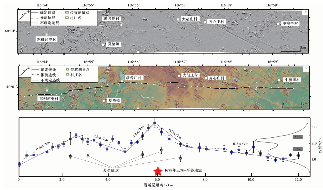
图 5 断层的几何结构及位错沿断层的分布特征 a 山影图; b 断层迹线展布; c 垂直位错沿断层的分布
Fig. 5 High-resolution DEM revealed fault trace and vertical offsets distribution.
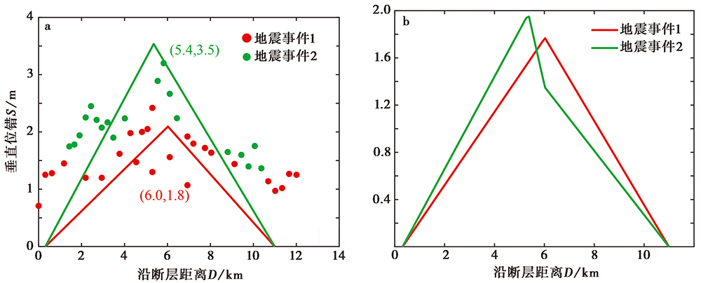
图 6 利用Paleo_Slip-Length方法获得的断层垂直位移揭示的2次地震事件的同震位移分布 a 模拟分析揭示的2次地震事件对应的位错点; b 模拟分析揭示的2次地震事件的同震位移分布
Fig. 6 Extraction of co-seismic slip distribution from cumulative offsets.
| 计算方法 | 断层类型 | 计算公式 | 计算结果/MW |
|---|---|---|---|
| 地表破裂长度(SRL) | 正断层 | M=4.86+1.32×lg(SRL) | 6.29 |
| 通用 | M=5.08+1.16×lg(SRL) | 6.34 | |
| 破裂面积(RA) | 正断层 | M=3.93+1.02×lg(RA) | 6.24 |
| 通用 | M=4.07+0.98×lg(RA) | 6.29 | |
| 平均位移(AD) | 正断层 | M=6.78+0.65×lg(AD) | 6.95 |
| 通用 | M=6.93+0.82×lg(AD) | 7.15 |
表2 利用不同方法获得的地表破裂对应的矩震级
Table 2 Moment magnitude determination using various methods
| 计算方法 | 断层类型 | 计算公式 | 计算结果/MW |
|---|---|---|---|
| 地表破裂长度(SRL) | 正断层 | M=4.86+1.32×lg(SRL) | 6.29 |
| 通用 | M=5.08+1.16×lg(SRL) | 6.34 | |
| 破裂面积(RA) | 正断层 | M=3.93+1.02×lg(RA) | 6.24 |
| 通用 | M=4.07+0.98×lg(RA) | 6.29 | |
| 平均位移(AD) | 正断层 | M=6.78+0.65×lg(AD) | 6.95 |
| 通用 | M=6.93+0.82×lg(AD) | 7.15 |
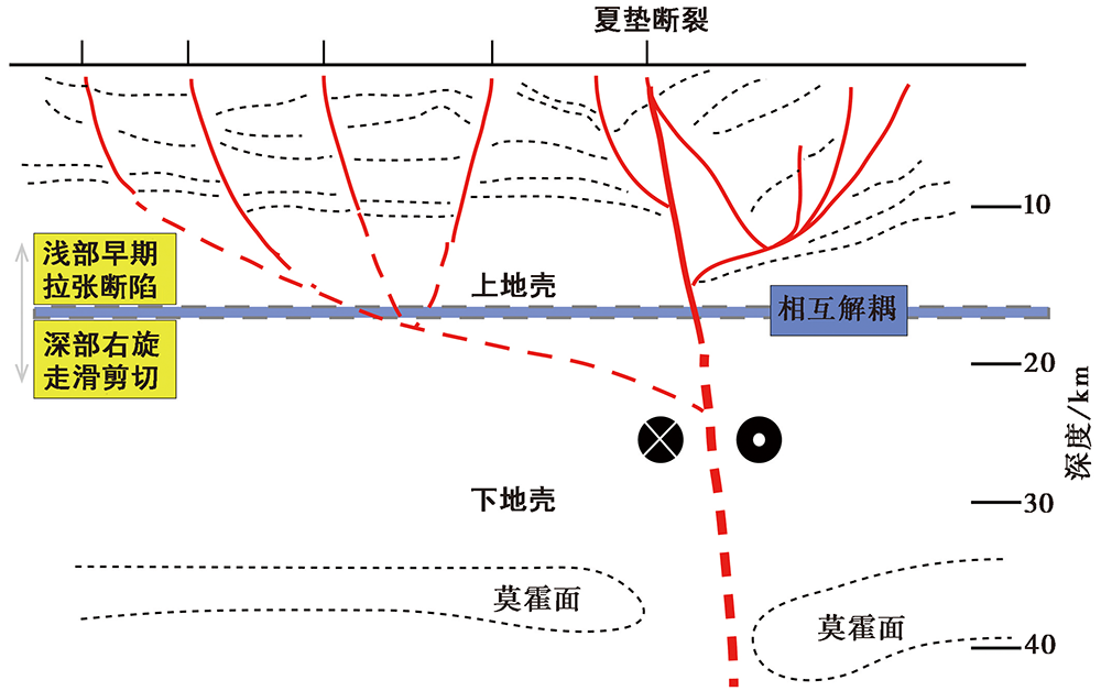
图 7 夏垫断裂深浅构造的解耦关系分布(据刘保金等, 2009)
Fig. 7 Decoupling relationship between shallow and deep structure of Xiadian Fault(after LIU Bao-jin et al., 2009).
| [1] | 北京市地质矿产局. 1991. 北京市区域地质志[M]. 北京: 地质出版社. |
| Bureau of Geology and Mineral Resources of Beijing Municipality. 1991. Regional Geology of Beijing Municipality[M]. Geological Publishing House, Beijing. (in Chinese) | |
| [2] | 陈成沟, 邢成起, 胡乐银, 等. 2017. 北京及其邻区小震重定位与活动构造分析[J]. 地震, 37(3): 84-94. |
| CHEN Cheng-gou, XING Cheng-qi, HU Le-yin, et al. 2017. Relocation of small earthquakes and active tectonics in Beijing and its adjacent areas[J]. Earthquake, 37(3): 84-94. (in Chinese) | |
| [3] | 高文学, 马瑾. 1993. 首都圈地震地质环境与地震灾害[M]. 北京: 地震出版社: 3-51. |
| GAO Wen-xue, MA Jin. 1993. Seismo-geological Background and Earthquake Hazard in Beijing Area[M]. Seismological Press, Beijing: 3-51. (in Chinese) | |
| [4] | 高战武, 陈棋福, 黄金莉, 等. 2010. 北京地区主要活动断裂深部速度结构特征及强震构造分析[J]. 震灾防御技术, 5(3): 271-280. |
| GAO Zhan-wu, CHEN Qi-fu, HUANG Jin-li, et al. 2010. Velocity structure beneath the active faults in Beijing area and their seismotectonic characteristics[J]. Technology for Earthquake Disaster Prevention, 5(3): 271-280. (in Chinese) | |
| [5] | 高战武, 徐杰, 宋长青, 等. 2001. 张家口-蓬莱断裂带的分段特征[J]. 华北地震科学, 19(1): 35-42. |
| GAO Zhan-wu, XU Jie, SONG Chang-qing, et al. 2001. The segmental character of Zhangjiakou-Penglai Fault[J]. North China Earthquake Science, 19(1): 35-42. (in Chinese) | |
| [6] | 江娃利, 侯治华, 肖振敏, 等. 2000. 北京平原夏垫断裂齐心庄探槽古地震事件分析[J]. 地震地质, 22(4): 413-422. |
| JIANG Wa-li, HOU Zhi-hua, XIAO Zhen-min, et al. 2000. Study on paleoearthquakes of Qixinzhuang trench at the Xiadian Fault, Beijing plain[J]. Seismology and Geology, 22(4): 413-422. (in Chinese) | |
| [7] | 李乐, 陈棋福, 陈颙. 2007. 首都圈地震活动构造成因的小震精定位分析[J]. 地球物理学进展, 22(1): 24-34. |
| LI Le, CHEN Qi-fu, CHEN Yong. 2007. Relocated seismicity in Big Beijing area and its tectonic implication[J]. Progress in Geophysics, 22(1): 24-34. (in Chinese) | |
| [8] | 林向东, 袁怀玉, 徐平, 等. 2017. 华北地区地震震源机制分区特征[J]. 地球物理学报, 60(12): 4589-4622. |
| LIN Xiang-dong, YUAN Huai-yu, XU Ping, et al. 2017. Zonational characteristics of earthquake focal mechanism solutions in North China[J]. Chinese Journal of Geophysics, 60(12): 4589-4622. (in Chinese) | |
| [9] | 刘保金, 寇昆朋, 胡平, 等. 2009. 北京平原西北部地壳浅部结构和隐伏活动断裂: 由地震反射剖面揭示[J]. 地球物理学报, 52(8): 2015-2025. |
| LIU Bao-jin, KOU Kun-peng, HU Ping, et al. 2009. The crustal shallow structures and buried active faults revealed by seismic reflection profiles in northwestern area of Beijing plain[J]. Chinese Journal of Geophysics, 52(8): 2015-2025. (in Chinese) | |
| [10] | 刘保金, 张先康, 陈颙, 等. 2011. 三河-平谷8.0级地震区地壳结构和活动断裂研究: 利用单次覆盖深反射和浅层地震剖面[J]. 地球物理学报, 54(5): 1251-1259. |
| LIU Bao-jin, ZHANG Xian-kang, CHEN Yong, et al. 2011. Research on crustal structure and active fault in the Sanhe-Pinggu earthquake(M8.0)zone based on single-fold deep seismic reflection and shallow seismic reflection profiling[J]. Chinese Journal of Geophysics, 54(5): 1251-1259. (in Chinese) | |
| [11] | 刘瑞丰, 陈运泰, 任枭, 等. 2015. 震级的测定[M]. 北京: 地震出版社: 3-28. |
| LIU Rui-feng, CHEN Yun-tai, REN Xiao, et al. 2015. Determination of Earthquake Magnitude[M]. Seismological Press, Beijing: 3-28. (in Chinese) | |
| [12] | 刘瑞丰, 陈运泰, 王丽艳. 2018. 新的震级国家标准的技术要点与主要特点[J]. 地震地磁观测与研究, 39(1): 1-11. |
| LIU Rui-feng, CHEN Yun-tai, WANG Li-yan. 2018. The technical key points and main features of the new national standard of magnitude[J]. Seismological and Geomagnetic Observation and Research, 39(1): 1-11. (in Chinese) | |
| [13] | 毛昌伟, 丁锐, 龚正, 等. 2010. 1679年三河-平谷8级地震地表断层陡坎的GPS测量 [G]. 中国地震局地壳应力研究所. 地壳构造与地壳应力文集: 17-24. |
| MAO Chang-wei, DING Rui, GONG Zheng, et al. 2010. GPS survey of the surface fault scarp of 1679 Sanhe-Pinggu M8 earthquake [G]. Bulletin of the Institute of Crustal Dynamics, 17-24. (in Chinese) | |
| [14] | 孟宪梁, 杜春涛, 王瑞, 等. 1983. 1679年三河-平谷大震的地震断裂带[J]. 地震, 3(3): 20-25. |
| MENG Xian-liang, DU Chun-tao, WANG Rui, et al. 1983. Rupture of the Sanhe-Pinggu earthquake of 1679[J]. Earthquake, 3(3): 20-25. (in Chinese) | |
| [15] | 彭一民, 李鼎容, 谢振钊, 等. 1981. 北京平原区同生断裂的某些特征及其研究意义[J]. 地震地质, 3(2): 57-64. |
| PENG Yi-min, LI Ding-rong, XIE Zhen-zhao, et al. 1981. Some features of contemporaneous faults in Beijing plain and their significance[J]. Seismology and Geology, 3(2): 57-64. (in Chinese) | |
| [16] | 冉勇康, 邓起东, 杨晓平, 等. 1997. 1679年三河-平谷8级地震发震断层的古地震及其重复间隔[J]. 地震地质, 19(3): 193-201. |
| RAN Yong-kang, DENG Qi-dong, YANG Xiao-ping, et al. 1997. Paleoearthquakes and recurrence interval on the seismogenic fault of 1679 Sanhe-Pinggu M8 earthquake, Hebei and Beijing[J]. Seismology and Geology, 19(3): 193-201. (in Chinese) | |
| [17] | 向宏发, 方仲景, 徐杰, 等. 1988. 三河-平谷8级地震区的构造背景与大震重复性研究[J]. 地震地质, 10(1): 15-28. |
| XIANG Hong-fa, FANG Zhong-jing, XU Jie, et al. 1988. Tectonic setting and earthquake repeatability on the seismogenic fault of 1679 M8.0 Sanhe-Pinggu earthquake[J]. Seismology and Geology, 10(1): 15-28. (in Chinese) | |
| [18] | 徐锡伟, 吴卫民, 张先康, 等. 2002. 首都圈地区地壳最新构造变动与地震[M]. 北京: 科学出版社: 3-28. |
| XU Xi-wei, WU Wei-min, ZHANG Xian-kang, et al. 2002. The Latest Crustal Tectonic and Earthquakes in Capital Circle Area[M]. Science Press, Beijing: 3-28. (in Chinese) | |
| [19] | 于湘伟, 陈运泰, 张怀. 2010. 京津唐地区地壳三维P波速度结构与地震活动性分析[J]. 地球物理学报, 53(8): 1817-1828. |
| YU Xiang-wei, CHEN Yun-tai, ZHANG Huai. 2010. Three-dimensional crustal P-wave velocity structure and seismicity analysis in Beijing-Tianjin-Tangshan region[J]. Chinese Journal of Geophysics, 53(8): 1817-1828. (in Chinese) | |
| [20] | 张培震, 邓起东, 张国民, 等. 2003. 中国大陆的强震活动与活动地块[J]. 中国科学(D辑), 33(S1): 12-20. |
| ZHANG Pei-zhen, DENG Qi-dong, ZHANG Guo-min, et al. 2003. Active tectonic blocks and strong earthquakes in the continent of China[J]. Science in China(Ser D), 33(S1): 12-20. (in Chinese) | |
| [21] | 张培震, 邓起东, 张竹琪, 等. 2013. 中国大陆的活动断裂、 地震灾害及其动力过程[J]. 中国科学(D辑), 43(10): 1607-1620. |
| ZHANG Pei-zhen, DENG Qi-dong, ZHANG Zhu-qi, et al. 2013. Active faults, earthquake hazards and associated geodynamic processes in continental China[J]. Science in China(Ser D), 43(10): 1607-1620. (in Chinese) | |
| [22] | 张先康, 赵金仁, 刘国华, 等. 2002. 三河-平谷8.0级大震区震源细结构的深地震反射探测研究[J]. 中国地震, 18(4): 326-336. |
| ZHANG Xian-kang, ZHAO Jin-ren, LIU Guo-hua, et al. 2002. Study on fine crustal structure of the Sanhe-Pinggu earthquake(M8.0)region by deep seismic reflection profiling[J]. Earthquake Research in China, 18(4): 326-336. (in Chinese) | |
| [23] | 赵成彬, 酆少英, 秦学业, 等. 2010. 夏垫断裂浅部特征高分辨反射地震探测研究[J]. 地震研究, 33(1): 81-85. |
| ZHAO Cheng-bin, FENG Shao-ying, QIN Xue-ye, et al. 2010. Research on the shallow structure characteristics of Xiadian Fault using high-resolution artificial seismic exploration method[J]. Journal of Seismological Research, 33(1): 81-85. (in Chinese) | |
| [24] | Bai L X, Xu X W, Luo H, et al. 2021. Angular unconformity of the late Quaternary strata in the Hetao Basin, north of the Ordos Block(West China): Timing and its tectonic implications[J]. Frontiers in Earth Science, 9(64789): 1-16. |
| [25] |
Bi H Y, Zheng W, Ge W, et al. 2018. Constraining the distribution of vertical slip on the South Heli Shan Fault(northeastern Tibet)from high-resolution topographic data[J]. Journal of Geophysical Research: Solid Earth, 123(3): 2484-2501.
DOI URL |
| [26] |
Chen T, Liu-Zeng J, Shao Y, et al. 2018. Geomorphic offsets along the creeping Laohu Shan section of the Haiyuan Fault, northern Tibetan plateau[J]. Geosphere, 14(3): 1165-1186.
DOI URL |
| [27] |
Duross C B, Bunds M P, Gold R D, et al. 2019. Variable normal-fault rupture behavior, northern Lost River fault zone, Idaho, USA[J]. Geosphere, 15(6): 1869-1892.
DOI URL |
| [28] |
Haddon E K, Amos C B, Zielke O, et al. 2016. Surface slip during large Owens Valley earthquakes[J]. Geochemistry, Geophysics, Geosystems, 17(6): 2239-2269.
DOI URL |
| [29] | Hanks T C, Kanamori H. 1979. A moment magnitude scale[J]. Journal of Geophysical Research: Solid Earth, 84(B5): 2348-2350. |
| [30] | Hetzel R, Hampel A, Gebbeken P, et al. 2019. A constant slip rate for the western Qilian Shan frontal thrust during the last 200ka consistent with GPS-derived and geological shortening rates[J]. Earth and Planetary Science Letters, 59:100-113. |
| [31] |
Jiang W, Zhang J, Han Z, et al. 2017. Characteristic slip of strong earthquakes along the Yishu fault zone in East China evidenced by offset landforms[J]. Tectonics, 36(9-10): 1947-1965.
DOI URL |
| [32] |
Kang W, Xu X, Oskin M E, et al. 2019. Characteristic slip distribution and earthquake recurrence along the eastern Altyn Tagh Fault revealed by high-resolution topographic data[J]. Geosphere, 16(1): 392-406.
DOI URL |
| [33] |
Klinger Y, Etchebes M, Tapponnier P, et al. 2011. Characteristic slip for five great earthquakes along the Fuyun Fault in China[J]. Nature Geoscience, 4(6): 389-392.
DOI URL |
| [34] |
Liu M, Stein S, Wang H. 2011. 2000 years of migrating earthquakes in North China: How earthquakes in midcontinent differ from those at plate boundaries[J]. Lithosphere, 3(2): 128-132.
DOI URL |
| [35] |
Liu-Zeng J, Zhang Z, Wen L, et al. 2009. Co-seismic ruptures of the 12 May 2008, MS8.0 Wenchuan earthquake, Sichuan: East-west crustal shortening on oblique, parallel thrusts along the eastern edge of Tibet[J]. Earth and Planetary Science Letters, 286(3-4): 355-370.
DOI URL |
| [36] |
Manighetti I, Caulet C, Barros L D, et al. 2015. Generic along-strike segmentation of Afar normal faults, East Africa: Implications on fault growth and stress heterogeneity on seismogenic fault planes[J]. Geochemistry Geophysics Geosystems, 16(2): 443-467.
DOI URL |
| [37] |
Manighetti I, Perrin C, Gaudemer Y, et al. 2020. Repeated giant earthquakes on the Wairarapa Fault, New Zealand, revealed by Lidar-based paleoseismology[J]. Scientific Reports, 10(1): 1-11.
DOI URL |
| [38] | McGill S F, Sieh K. 1991. Surficial offsets on the central and eastern Garlock Fault associated with prehistoric earthquakes[J]. Journal of Geophysical Research: Solid Earth, 96(B13): 21597-21621. |
| [39] | Ren Z, Zhang Z, Chen T, et al. 2016. Clustering of offsets on the Haiyuan Fault and their relationship to paleo-earthquakes[J]. Geological Society of America Bulletin, 128(1-2): 3-18. |
| [40] |
Shen Z K, Zhao C K, Yin A, et al. 2000. Contemporary crustal deformation in East Asia constrained by Global Positioning System measurements[J]. Journal of Geophysical Research, 105(B3): 5721-5734.
DOI URL |
| [41] |
Shi W, Dong S W, Hu J M. 2020. Neotectonics around the Ordos Block, North China: A review and new insights[J]. Earth-Science Reviews, 200(1): 102969.
DOI URL |
| [42] |
Sieh K, Jones L, Hauksson E, et al. 1993. Near-field investigations of the Landers earthquake sequence, April to July 1992 [J]. Science, 260(5105): 171-176.
PMID |
| [43] |
Wei Z Y, He H L, Sun W, et al. 2020. Investigating thrust-fault growth and segment linkage using displacement distribution analysis in the active Duzhanzi thrust fault zone, northern Tian Shan of China[J]. Journal of Structural Geology, 133: 103990.
DOI URL |
| [44] | Wells D L, Coppersmith K J. 1994. New empirical relationships among magnitude, rupture length, rupture width, rupture area, and surface displacement[J]. Bulletin of the Seismological Society of America, 84(4): 974-1002. |
| [45] |
Zielke O, Arrowsmith J R, Ludwig L G, et al. 2010. Slip in the 1857 and earlier large earthquakes along the Carrizo Plain, San Andreas Fault[J]. Science, 327(5969): 1119-1122.
DOI PMID |
| [1] | 王辽, 谢虹, 袁道阳, 李智敏, 薛善余, 苏瑞欢, 文亚猛, 苏琦. 结合野外考察的2022年门源MS6.9地震地表破裂带的高分七号影像特征[J]. 地震地质, 2023, 45(2): 401-421. |
| [2] | 吴中海, 白玛多吉, 叶强, 韩帅, 史亚然, 尼玛次仁, 高扬. 西藏阿里阿鲁错地堑系的第四纪活动性、最新同震地表破裂及其地震地质意义[J]. 地震地质, 2023, 45(1): 67-91. |
| [3] | 李东臣, 任俊杰, 张志文, 刘亮. 基于高分辨率无人机影像的地震地表破裂半自动提取方法--以2021年MS7.4青海玛多地震为例[J]. 地震地质, 2022, 44(6): 1484-1502. |
| [4] | 李传友, 孙凯, 马骏, 李俊杰, 梁明剑, 房立华. 四川泸定6.8级地震--鲜水河断裂带磨西段局部发起、 全段参与的一次复杂事件[J]. 地震地质, 2022, 44(6): 1648-1666. |
| [5] | 姚生海, 盖海龙, 殷翔, 刘炜, 张加庆, 袁建新. 阿木尼克山山前地表破裂带与1962年6.8级地震关系的讨论[J]. 地震地质, 2022, 44(4): 976-991. |
| [6] | 刘小利, 夏涛, 刘静, 姚文倩, 徐晶, 邓德贝尔, 韩龙飞, 贾治革, 邵延秀, 王焱, 乐子扬, 高天琪. 2021年青海玛多MW7.4地震分布式同震地表裂缝特征[J]. 地震地质, 2022, 44(2): 461-483. |
| [7] | 韩龙飞, 刘静, 姚文倩, 王文鑫, 刘小利, 高云鹏, 邵延秀, 李金阳. 2021年玛多MW7.4地震震中区地表破裂的精细填图及阶区内的分布式破裂讨论[J]. 地震地质, 2022, 44(2): 484-505. |
| [8] | 王文鑫, 邵延秀, 姚文倩, 刘静, 韩龙飞, 刘小利, 高云鹏, 王子君, 秦可心, 屠泓为. 基于摄影测量技术对玛多MW7.4地震地表破裂特征的快速提取及三维结构的室内重建[J]. 地震地质, 2022, 44(2): 524-540. |
| [9] | 姚文倩, 王子君, 刘静, 刘小利, 韩龙飞, 邵延秀, 王文鑫, 徐晶, 秦可心, 高云鹏, 王焱, 李金阳, 曾宪阳. 2021年青海玛多MW7.4地震同震地表破裂长度的讨论[J]. 地震地质, 2022, 44(2): 541-559. |
| [10] | 黄帅堂, 常想德, 马建, 胡伟华, 任静, 刘建明, 张文秀, 赖爱京. 天山北麓库松木契克山山前断裂东段断层陡坎研究[J]. 地震地质, 2022, 44(1): 20-34. |
| [11] | 盖海龙, 李智敏, 姚生海, 李鑫. 2022年青海门源MS6.9地震地表破裂特征的初步调查研究[J]. 地震地质, 2022, 44(1): 238-255. |
| [12] | 梁宽, 何仲太, 姜文亮, 李永生, 刘泽民. 2022年1月8日青海门源MS6.9地震的同震地表破裂特征[J]. 地震地质, 2022, 44(1): 256-278. |
| [13] | 梁子晗, 魏占玉, 庄其天, 孙稳, 何宏林. 基于高分辨率地形数据的富蕴M8.0地震地表破裂带精细特征[J]. 地震地质, 2021, 43(6): 1507-1523. |
| [14] | 姚生海, 盖海龙, 殷翔, 李鑫. 青海玛多MS7.4地震地表破裂带的基本特征和典型现象[J]. 地震地质, 2021, 43(5): 1060-1072. |
| [15] | 李智敏, 李文巧, 李涛, 徐岳仁, 苏鹏, 郭鹏, 孙浩越, 哈广浩, 陈桂华, 袁兆德, 李忠武, 李鑫, 杨理臣, 马震, 姚生海, 熊仁伟, 张彦博, 盖海龙, 殷翔, 徐玮阳, 董金元. 2021年5月22日青海玛多MS7.4地震的发震构造和地表破裂初步调查[J]. 地震地质, 2021, 43(3): 722-737. |
| 阅读次数 | ||||||
|
全文 |
|
|||||
|
摘要 |
|
|||||
