地震地质 ›› 2023, Vol. 45 ›› Issue (2): 401-421.DOI: 10.3969/j.issn.0253-4967.2023.02.006
王辽1)( ), 谢虹1,2),*(), 袁道阳3), 李智敏4), 薛善余1), 苏瑞欢3), 文亚猛3), 苏琦5)
修回日期:2022-09-26
出版日期:2023-04-20
发布日期:2023-05-18
通讯作者:
*谢虹, 女, 1982年生, 博士, 硕士生导师, 主要从事活动构造和构造地貌研究, E-mail: 作者简介:王辽, 男, 1998年生, 2021年于西南大学获地理信息科学专业学士学位, 现为中国地震局兰州地震研究所构造地质学专业在读硕士研究生, 主要从事活动构造与地震地质灾害研究, E-mail: 2667274493@qq.com。
基金资助:
WANG Liao1)(), XIE Hong1,2),*(), YUAN Dao-yang3), LI Zhi-min4), XUE Shan-yu1), SU Rui-huan3), WEN Ya-meng3), SU Qi5)
Revised:2022-09-26
Online:2023-04-20
Published:2023-05-18
摘要:
2022年1月8日, 青海省门源县发生了 MS6.9 地震。为及时全面了解地震同震地表破裂带的空间分布并准确判定发震构造, 文中通过对震后高分七号遥感影像进行解译判读, 综合野外考察核实, 获得了门源 MS6.9 地震同震地表破裂带的展布情况, 并识别出多种典型的同震破裂地貌, 总结了多种同震地貌的影像特征。结果表明, 此次地震产生了2条主要的地表破裂带, 呈左阶斜列展布。北支主破裂带分布于冷龙岭断裂西段, 长约22km, 走向 100°N~120°E; 南支次级破裂带分布在托莱山断裂东段的局部段上, 长约4km, 走向为N90°E, 2条破裂带总长约26km; 沿破裂带形成了一系列典型左旋走滑同震地貌, 如张裂隙、张剪裂隙、挤压脊、挤压鼓包、左旋纹沟、左旋断错路基等; 在此基础上, 文中还对冷龙岭地区典型左旋地貌的累积位错进行了测量, 并与前人的测量结果作对比研究, 得到了较为准确的测量结果。文中基于高分影像对断裂沿线典型的断错地貌开展研究, 不仅可为高分七号卫星数据的地质应用积累实例, 所得结果也可为未来构造地貌研究提供强有力的数据支撑。
中图分类号:
王辽, 谢虹, 袁道阳, 李智敏, 薛善余, 苏瑞欢, 文亚猛, 苏琦. 结合野外考察的2022年门源MS6.9地震地表破裂带的高分七号影像特征[J]. 地震地质, 2023, 45(2): 401-421.
WANG Liao, XIE Hong, YUAN Dao-yang, LI Zhi-min, XUE Shan-yu, SU Rui-huan, WEN Ya-meng, SU Qi. THE SURFACE RUPTURE CHARACTERISTICS BASED ON THE GF-7 IMAGES INTERPRETATION AND THE FIELD INVESTIGA-TION OF THE 2022 MENYUAN MS6.9 EARTHQUAKE[J]. SEISMOLOGY AND GEOLOGY, 2023, 45(2): 401-421.

图1 青海门源 MS6.9 地震构造背景图 图a据文献(王未来等, 2021)改编, 红色线条为活动块体边界。Ⅰ 戈壁-阿拉善地块; Ⅱ 塔里木地块; Ⅲ 柴达木地块; Ⅳ 巴颜喀拉地块; Ⅴ 羌塘地块; Ⅵ 拉萨地块; Ⅶ 喜马拉雅地块。f1西昆仑-祁连山加里东期缝合带; f2昆仑山华力西期缝合带; f3金沙江印支缝合带; f4班公湖-怒江燕山期缝合带; f5雅鲁藏布江喜马拉雅期缝合带。图b中黑色线条是全新世以来的活动断裂。F1冷龙岭断裂; F2托莱山断裂; F3肃南-祁连断裂; F4金强河断裂; F5老虎山断裂; F6天桥沟-黄羊川断裂; F7马雅雪山断裂; F8日月山断裂; F9达坂山断裂; F10民乐-大马营断裂; F11榆木山东缘断裂; F12龙首山南缘断裂。历史地震的时间为1500-2021年, MS>5.0。 图c为震中附近的详细构造背景图, 地震序列的精定位结果来自文献(Fan et al., 2022)
Fig. 1 Seismogenic tectonic background map of the Menyuan MS6.9 earthquake in Qinghai Province.
| 影像获取时间 | 数据类型 | 分辨率 | 影像中心经纬度 |
|---|---|---|---|
| 2021年11月30日 | GF-7 | 全色0.65m,多光谱2.6m | 37.8°N, 101.2°E |
| 2021年12月2日 | GF-6 | 全色2m,多光谱8m | 38.0°N, 101.6°E |
| 2021年12月2日 | GF-6 | 全色2m,多光谱8m | 38.8°N, 101.9°E |
| 2022年1月8日 | GF-7 | 全色0.65m,多光谱2.6m | 37.8°N, 101.3°E |
| 2022年1月8日 | GF-7 | 全色0.65m,多光谱2.6m | 37.6°N, 101.2°E |
| 2022年1月8日 | GF-6 | 全色2m,多光谱8m | 38.0°N, 101.0°E |
| 2022年1月13日 | GF-7 | 全色0.65m,多光谱2.6m | 37.6°N, 101.5°E |
表1 遥感影像参数
Table1 Remote sensing image parameters
| 影像获取时间 | 数据类型 | 分辨率 | 影像中心经纬度 |
|---|---|---|---|
| 2021年11月30日 | GF-7 | 全色0.65m,多光谱2.6m | 37.8°N, 101.2°E |
| 2021年12月2日 | GF-6 | 全色2m,多光谱8m | 38.0°N, 101.6°E |
| 2021年12月2日 | GF-6 | 全色2m,多光谱8m | 38.8°N, 101.9°E |
| 2022年1月8日 | GF-7 | 全色0.65m,多光谱2.6m | 37.8°N, 101.3°E |
| 2022年1月8日 | GF-7 | 全色0.65m,多光谱2.6m | 37.6°N, 101.2°E |
| 2022年1月8日 | GF-6 | 全色2m,多光谱8m | 38.0°N, 101.0°E |
| 2022年1月13日 | GF-7 | 全色0.65m,多光谱2.6m | 37.6°N, 101.5°E |

图2 门源 MS6.9 地震的同震地表破裂带 a 基于Sentinel-2数据确定的门源地震同震地表水平位移结果(2022-01-05-2022-01-10); b 高分七号遥感影像, 分辨率为0.65m, 余震精定位数据来自文献(Fan et al., 2022)
Fig. 2 Coseismic surface rupture zone of the Mengyuan MS6.9 earthquake.

图3 道河西段的高分七号遥感影像与实地调查图片 a 道河西段部分地区的高分七号遥感影像; b 多条地表破裂展布; c 挤压脊与挤压鼓包(高0.3~0.6m); d 地震陡坎(陡坎高0.2~0.4m); e 挤压鼓包(宽3m, 高0.8m)
Fig. 3 Remote sensing images of GF-7 and field survey photos of the west of the Daohe segment.

图4 硫磺沟段的高分七号遥感影像与实地调查图片 a 硫磺沟段地区的高分七号遥感影像; b 雁列状展布的挤压鼓包和张裂隙; c “Z”字形的连续挤压隆起; d 地表栅栏位错(2.2m); e 剪切裂隙和挤压隆起(宽1.1m, 深6~7m); f 剪切裂隙(宽1.7m); g 挤压脊(高0.7m); h 道路剪切裂隙;i 道路破裂与挤压隆起(道路位错0.5m和1.2m)
Fig. 4 Remote sensing images of GF-7 and field survey photos of the Liuhuanggou segment.

图5 红沟段的高分七号遥感影像与实地调查图片 a 红沟西部地区的高分七号遥感影像; b 红沟东部地区的高分七号遥感影像; c 高铁轨道变形; d 同震地表破裂
Fig. 5 Remote sensing images of GF-7 and field survey photos of the Honggou segment.

图6 永安河段的高分七号遥感影像与实地调查图片 a 永安河段部分地区的高分七号遥感影像; b 地表破裂的次级张性破裂; c 冰面上形成的挤压鼓包与地震陡坎(陡坎高0.1~0.3m); d 砾石滩形成的挤压脊与挤压鼓包、地震陡坎(陡坎高0.3~0.5m); e 多条地表破裂
Fig. 6 Remote sensing images of GF-7 and field survey photos of the Yongan River segment.

图7 一棵树沟段的高分七号遥感影像 a 一棵树沟段部分地区的高分七号遥感影像; b 震前局部地区的高分六号遥感影像; c 震后局部地区的高分七号遥感影像
Fig. 7 Remote sensing images of GF-7 of the Yikeshugou segment.

图8 托莱山段的高分七号遥感影像与实地调查照片 a 托莱山段部分地区的高分七号遥感影像; b 地表破裂带; c 挤压脊; d 地表破裂尖灭; e 地表破裂带
Fig. 8 Remote sensing images of GF-7 and field survey photos of the Tuolaishan section.
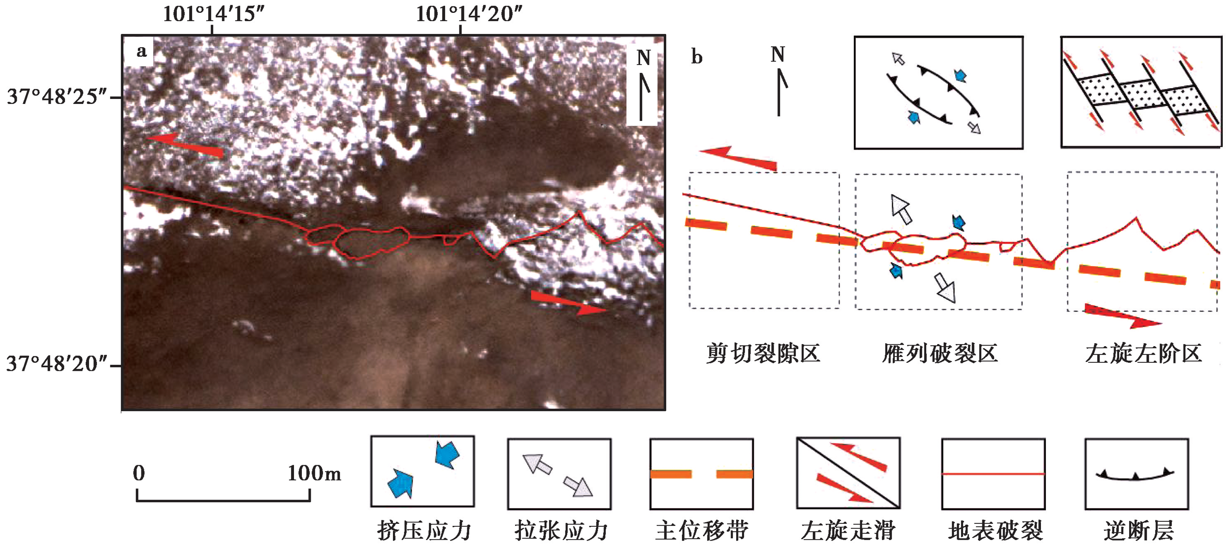
图9 硫磺沟段典型同震地貌构造解析
Fig. 9 Structural analysis of the coseismic landform in Liuhuanggou.

图10 同震破裂地貌的细节展示 a、b 硫磺沟段的地貌细节; c、d 道河的地貌细节; e、f 道河西段的地貌细节; g、h 硫磺沟公路位错的地貌细节
Fig. 10 Detail display of coseismic rupture landform.

图11 左旋冲沟地貌的高分七号遥感影像与Google Earth影像图 a 高分七号遥感影像与左旋冲沟地貌; b、c 冲沟地貌图, 来自Google Earth
Fig. 11 Left-lateral gully landform on GF-7 remote sensing image and Google Earth image.
| 地点 | 地貌单元 | 命名 | 累计左旋位错/m |
|---|---|---|---|
| 硫磺沟 | 冲沟 | G1 | 37±1.5 |
| 硫磺沟 | 冲沟 | G2 | 30±0.9 |
| 硫磺沟 | 冲沟 | G3 | 42±2 |
| 硫磺沟 | 冲沟 | G4 | 124±3 |
| 硫磺沟 | 冲沟 | G5 | 107±4 |
| 硫磺沟 | 冲沟 | G6 | 89±2.8 |
| 硫磺沟 | 冲沟 | G7 | 73±1.5 |
| 红沟 | 冲沟 | G8 | 40±1 |
| 红沟 | 山脊 | G9 | 51±1.5 |
| 红沟 | 山脊 | G10 | 165±4.4 |
| 红沟 | 冲沟 | G11 | 95±1 |
| 红沟 | 冲沟 | G12 | 50±2.1 |
| 红沟 | 冲沟 | G13 | 86+2.5 |
| 红沟 | 山脊 | G14 | 90±3 |
| 红沟 | 冲沟 | G15 | 63±2.5 |
| 红沟 | 冲沟 | G16 | 102±3.1 |
| 红沟 | 冲沟 | G17 | 68±1.7 |
| 敖包沟 | 山脊 | G18 | 111±4 |
| 敖包沟 | 冲沟 | G19 | 145±3 |
| 敖包沟 | 冲沟 | G20 | 97±4 |
| 敖包沟 | 冲沟 | G21 | 75±2.8 |
| 下红沟 | 冲沟 | G22 | 86±2.7 |
| 下红沟 | 冰碛 | G23 | 99±3.5 |
| 上红沟 | 冰碛 | G24 | 75±2.1 |
表2 冷龙岭断裂带的左旋地貌水平位错
Table2 Cumulative dislocation of left-lateral landform in Lenglongling fault zone
| 地点 | 地貌单元 | 命名 | 累计左旋位错/m |
|---|---|---|---|
| 硫磺沟 | 冲沟 | G1 | 37±1.5 |
| 硫磺沟 | 冲沟 | G2 | 30±0.9 |
| 硫磺沟 | 冲沟 | G3 | 42±2 |
| 硫磺沟 | 冲沟 | G4 | 124±3 |
| 硫磺沟 | 冲沟 | G5 | 107±4 |
| 硫磺沟 | 冲沟 | G6 | 89±2.8 |
| 硫磺沟 | 冲沟 | G7 | 73±1.5 |
| 红沟 | 冲沟 | G8 | 40±1 |
| 红沟 | 山脊 | G9 | 51±1.5 |
| 红沟 | 山脊 | G10 | 165±4.4 |
| 红沟 | 冲沟 | G11 | 95±1 |
| 红沟 | 冲沟 | G12 | 50±2.1 |
| 红沟 | 冲沟 | G13 | 86+2.5 |
| 红沟 | 山脊 | G14 | 90±3 |
| 红沟 | 冲沟 | G15 | 63±2.5 |
| 红沟 | 冲沟 | G16 | 102±3.1 |
| 红沟 | 冲沟 | G17 | 68±1.7 |
| 敖包沟 | 山脊 | G18 | 111±4 |
| 敖包沟 | 冲沟 | G19 | 145±3 |
| 敖包沟 | 冲沟 | G20 | 97±4 |
| 敖包沟 | 冲沟 | G21 | 75±2.8 |
| 下红沟 | 冲沟 | G22 | 86±2.7 |
| 下红沟 | 冰碛 | G23 | 99±3.5 |
| 上红沟 | 冰碛 | G24 | 75±2.1 |
| [1] | 董彦芳, 袁小祥, 王晓青, 等. 2012. 2010年青海玉树 MS7.1 地震地表破裂特征的高分辨率遥感分析[J]. 地震, 32(1): 82-92. |
| DONG Yan-fang, YUAN Xiao-xiang, WANG Xiao-qing, et al. 2012. Analysis of surface ruptures caused by the 2010 MS7.1 Yushu, Qinghai earthquake using high resolution remote sensing images[J]. Seismology and Geology, 32(1): 82-92. (in Chinese) | |
| [2] | 付碧宏, 时丕龙, 张之武. 2008. 四川汶川 MS8.0 大地震地表破裂带的遥感影像解析[J]. 地质学报, 82(12): 1679-1687. |
| FU Bi-hong, SHI Pi-long, ZHANG Zhi-wu. 2008. Spatial characteristics of the surface rupture produced by the MS8.0 Wenchuan earthquake using high-resolution remote sensing imagery[J]. Acta Geologica Sinica, 82(12): 1679-1687. (in Chinese) | |
| [3] | 盖海龙, 李智敏, 姚生海, 等. 2022. 2022年青海门源 MS6.9 地震地表破裂特征的初步调查研究[J]. 地震地质, 44(1): 238-255. |
| GAI Hai-long, LI Zhi-min, YAO Sheng-hai, et al. 2022. Preliminary investigation and research on surface rupture characteristics of the 2022 Qinghai Menyuan MS6.9 earthquake[J]. Seismology and Geology, 44(1): 238-255. (in Chinese) | |
| [4] | 国家地震局震害防御司. 1995. 中国历史强震目录[Z]. 北京: 地震出版社: 1-514. |
| Department of Earthquake Disaster Prevention of State Seismological Bureau. 1995. The Catalogue of Historical Strong Earthquakes in China[Z]. Seismological Press, Beijing: 1-514. (in Chinese) | |
| [5] | 郭鹏. 2016. 冷龙岭断裂全新世滑动速率与发震能力研究[D]. 北京: 中国地震局地质研究所. |
| GUO Peng. 2016. Holocene slip rate and seismogenic capacity of Lenglongling Fault, northeastern margin of the Tibetan plateau.[D]. Institute of Geology, China Earthquake Administration, Beijing. (in Chinese) | |
| [6] | 郭鹏, 韩竹军, 安艳芬, 等. 2017a. 冷龙岭断裂系活动性与2016年门源6.4级地震构造研究[J]. 中国科学(D辑), 47(5): 617-630. |
| GUO Peng, HAN Zhu-jun, AN Yan-fen, et al. 2017a. Activity of the Lenglongling fault system and seismotectonics of the 2016 MS6.4 Menyuan earthquake[J]. Science in China(Ser D), 47(5): 617-630. (in Chinese) | |
| [7] |
郭鹏, 韩竹军, 姜文亮, 等. 2017b. 青藏高原东北缘冷龙岭断裂全新世左旋滑动速率[J]. 地震地质, 39(2): 323-341. doi: 10.3969/j.issn.0253-4967.2017.02.005.
DOI |
| GUO Peng, HAN Zhu-jun, JIANG Wen-liang, et al. 2017b. Holocene left-lateral slip rate of the Lenglongling Fault, northeastern margin of the Tibetan plateau[J]. Seismology and Geology, 39(2): 323-341. (in Chinese) | |
| [8] | 韩帅, 吴中海, 高扬, 等. 2022. 2022年1月8日青海门源 MS6.9 地震地表破裂考察的初步结果及对冷龙岭断裂活动行为和区域强震危险性的启示[J]. 地质力学学报, 28(2): 155-168. |
| HAN Shuai, WU Zhong-hai, GAO Yang, et al. 2022. Surface rupture investigation of the 2022 Menyuan MS6.9 earthquake, Qinghai, China: Implications for the fault behavior of the Lenglongling Fault and regional intense earthquake risk[J]. Journal of Geomechanics, 28(2): 155-168. (in Chinese) | |
| [9] | 何文贵, 刘百篪, 袁道阳, 等. 2000. 冷龙岭活动断裂的滑动速率研究[J]. 西北地震学报, 22(1): 91-98. |
| HE Wen-gui, LIU Bai-chi, YUAN Dao-yang, et al. 2000. Research on slip rates of the Lenglongling active fault zone[J]. Northwestern Seismological Journal, 22(1): 91-98. (in Chinese) | |
| [10] | 何文贵, 袁道阳, 葛伟鹏, 等. 2010. 祁连山活动断裂带中东段冷龙岭断裂滑动速率的精确厘定[J]. 地震, 30(1): 131-137. |
| HE Wen-gui, YUAN Dao-yang, GE Wei-peng, et al. 2010. Determination of the slip rate of the Lenglongling Fault in the middle and eastern segments of the Qilian Mountains active fault zone[J]. Earthquake, 30(1): 131-137. (in Chinese) | |
| [11] | 胡朝忠, 杨攀新, 李智敏, 等. 2016. 2016年1月21日青海门源6.4级地震的发震机制探讨[J]. 地球物理学报, 59(5): 1637-1646. |
| HU Chao-zhong, YANG Pan-xin, LI Zhi-min, et al. 2016. Seismogenic mechanism of the 21 January 2016 Menyuan, Qinghai MS6.4 earthquake[J]. Chinese Journal of Geophysics, 59(5): 1637-1646. (in Chinese) | |
| [12] | 姜文亮, 李永生, 田云锋, 等. 2017. 冷龙岭地区2016年青海门源6.4级地震发震构造特征[J]. 地震地质, 39(3): 536-549. |
| JIANG Wen-liang, LI Yong-sheng, TIAN Yun-feng, et al. 2017. Research of seismogenic structure of the Menyuan MS6.4 earthquake on January 21, 2016 in Lenglongling area of NE Tibetan plateau[J]. Seismology and Geology, 39(3): 536-549. (in Chinese) | |
| [13] | 李强, 江在森, 武艳强, 等. 2013. 海原-六盘山断裂带现今构造变形特征[J]. 大地测量与地球动力学, 33(2): 18-22. |
| LI Qiang, JIANG Zai-sen, WU Yan-qiang, et al. 2013. Present-day tectonic deformation characteristics of Haiyuan-Liupanshan fault zone[J]. Journal of Geodesy and Geodynamics, 33(2): 18-22. (in Chinese) | |
| [14] | 李智敏, 盖海龙, 李鑫, 等. 2022. 2022年青海门源 MS6.9 地震发震构造和地表破裂初步调查[J]. 地质学报, 96(1): 330-335. |
| LI Zhi-min, GAI Hai-long, LI Xin, et al. 2022. Seismogenic fault and coseismic surface deformation of the Menyuan MS6.9 earthquake in Qinghai[J]. Acta Geologica Sinica, 96(1): 330-335. (in Chinese) | |
| [15] | 李智敏, 黄帅堂, 胡朝忠, 等. 2016. 2016年青海门源 MS6.4 地震发震构造遥感解译探讨[J]. 地震研究, 39(S1): 20-27, 133. |
| LI Zhi-min, HUANG Shuai-tang, HU Chao-zhong, et al. 2016. Discussion on the seismogenic structure remote sensing interpretation of the Qinghai Menyuan MS6.4 earthquake in 2016[J]. Journal of Seismological Research, 39(S1): 20-27, 133. (in Chinese) | |
| [16] | 梁宽, 何仲太, 姜文亮, 等. 2022. 2022年1月8日青海门源 MS6.9 地震的同震地表破裂特征[J]. 地震地质, 44(1): 256-278. |
| LIANG Kuan, HE Zhong-tai, JIANG Wen-liang, et al. 2022. Surface rupture characteristics of the Menyuan MS6.9 earthquake on January 8, 2022, Qinghai Province[J]. Seismology and Geology, 44(1): 256-278. (in Chinese) | |
| [17] | 刘百篪, 李清河, 刘小凤, 等. 2000. 祁连山活动地块东北部活动构造的定量研究与大地震危险性分析[J]. 西北地震学报, 22(2): 187-190. |
| LIU Bai-chi, LI Qing-he, LIU Xiao-feng, et al. 2000. Seismic risk evaluation and quantitative study of active seismotectonics in focal monitoring area on mid-east segment of Qilian Mountains[J]. Northwestern Seismological Journal, 22(2): 187-190. (in Chinese) | |
| [18] | 刘百篪, 袁道阳, 何文贵, 等. 1998. 中国地震学会第7次学术大会论文摘要集[C]. 北京: 地震出版社: 60. |
| LIU Bai-chi, YUAN Dao-yang, HE Wen-gui, et al. 1998. Abstracts of the Seventh Academic Conference of the Seismological Society of China[C]. Seismological Press, Beijing: 60. (in Chinese) | |
| [19] | 刘璐, 刘兴旺, 张波, 等. 2022. 利用高分影像识别门源 MS6.9 地震地表破裂带[J]. 地震工程学报, 44(2): 440-449. |
| LIU Lu, LIU Xing-wang, ZHANG Bo, et al. 2022. Recognition of surface ruptures of Menyuan MS6.9 earthquake using GF images[J]. China Earthquake Engineering Journal, 44(2): 440-449. (in Chinese) | |
| [20] | 马亮. 2017. 2016年青海门源 MS6.4 地震特征与地质构造[J]. 地震地磁观测与研究, 38(5): 1-7. |
| MA Liang. 2017. Principal features and seismic-tectonics of Qinghai Menyuan MS6.4 earthquake in 2016[J]. Seismological and Geomagnetic Observation and Research, 38(5): 1-7. (in Chinese) | |
| [21] | 潘家伟, 李海兵, Marie-Luce C, 等. 2022. 2022年青海门源 MS6.9 地震地表破裂带及发震构造研究[J]. 地质学报, 96(1): 215-231. |
| PAN Jia-wei, LI Hai-bing, Marie-Luce C, et al. 2022. Coseismic surface rupture and seismogenic structure of the 2022 MS6.9 Menyuan earthquake, Qinghai Province, China[J]. Acta Geologica Sinica, 96(1): 215-231. (in Chinese) | |
| [22] | 单新建, 李建华, 马超. 2005. 昆仑山口西 MS8.1 地震地表破裂带高分辨率卫星影像特征研究[J]. 地球物理学报, 48(2): 321-326. |
| SHAN Xin-jian, LI Jian-hua, MA Chao. 2005. Study on the feature of surface rupture zone of the west of Kunlunshan Pass earthquake(MS8.1)with high spatial resolution satellite images[J]. Chinese Journal of Geophysics, 48(2): 321-326. (in Chinese) | |
| [23] | 石峰, 何宏林, 张英. 2010. 青海玉树 MS7.1 地震地表破裂带的遥感影像解译[J]. 震灾防御技术, 5(2): 220-227. |
| SHI Feng, HE Hong-lin, ZHANG Ying. 2010. Remote sensing interpretation of the MS7.1 Yushu earthquake surface ruptures[J]. Technology for Earthquake Disaster Prevention, 5(2): 220-227. (in Chinese) | |
| [24] | 王未来, 房立华, 吴建平, 等. 2021. 2021年青海玛多 MS7.4 地震序列精定位研究[J]. 中国科学(D辑), 51(7): 1193-1202. |
| WANG Wei-lai, FANG Li-hua, WU Jian-ping, et al. 2021. Aftershock sequence relocation of the 2021 MS7.4 Maduo earthquake, Qinghai, China[J]. Science in China(Ser D), 51(7): 1193-1202. (in Chinese) | |
| [25] | 魏永明, 李剑南, 陈玉, 等. 2021. 不同类型发震断层的同震地表破裂光学遥感特征研究[J]. 第四纪研究, 41(6): 1513-1531. |
| WEI Yong-ming, LI Jian-nan, CHEN Yu, et al. 2021. Research on optical remote sensing characteristics of coseismic surface rupture of different types of seismogenic faults[J]. Quaternary Sciences, 41(6): 1513-1531. (in Chinese) | |
| [26] | 徐纪人, 姚立珣, 汪进. 1986. 1986年8月26日门源6.4级地震及其强余震的震源机制解[J]. 西北地震学报, 8(4): 82-84. |
| XU Ji-ren, YAO Li-xun, WANG Jin. 1986. Focal mechanism solution of the Menyuan MS6.4 earthquake and its strong aftershocks on August 26, 1986[J]. Northwestern Seismological Journal, 8(4): 82-84. (in Chinese) | |
| [27] | 徐岳仁, 陈立泽, 申旭辉, 等. 2015. 基于GF-1卫星影像解译2014年新疆于田 MS7.3 地震同震地表破裂带[J]. 地震, 35(2): 61-71. |
| XU Yue-ren, CHEN Li-ze, SHEN Xu-hui, et al. 2015. Interpretating coseismic surface rupture zone of the 2014 Yutian MS7.3 earthquake using GF-1 satellite images[J]. Earthquake, 35(2): 61-71. (in Chinese) | |
| [28] | 薛善余, 谢虹, 袁道阳, 等. 2022. 2022门源 MS6.9 地震地表破裂带震害特征调查[J]. 地震工程学报, 44(2): 458-467. |
| XUE Shan-yu, XIE Hong, YUAN Dao-yang, et al. 2022. Seismic disaster characteristics of the surface rupture of Menyuan MS6.9 earthquake in 2022[J]. China Earthquake Engineering Journal, 44(2): 458-467. (in Chinese) | |
| [29] | 袁道阳. 2003. 青藏高原东北缘晚新生代以来的构造变形特征与时空演化[D]. 北京: 中国地震局地质研究所. |
| YUAN Dao-yang. 2003. Tectonic deformation features and space-time evolution in northeastern margin of the Qinghai-Tibetan plateau since the late Cenozoic time[D]. Institute of Geology, China Earthquake Administration, Beijing. (in Chinese) | |
| [30] | 袁道阳, 刘百篪, 吕太乙, 等. 1998. 北祁连山东段活动断裂带的分段性研究[J]. 西北地震学报, 20(4): 27-34. |
| YUAN Dao-yang, LIU Bai-chi, LÜ Tai-yi, et al. 1998. Study on the segmentation in east segment of the northern Qilianshan fault zone[J]. Northwestern Seismological Journal, 20(4): 27-34. (in Chinese) | |
| [31] | 袁道阳, 张培震, 刘百篪, 等. 2004. 青藏高原东北缘晚第四纪活动构造的几何图像与构造转换[J]. 地质学报, 78(2): 270-278. |
| YUAN Dao-yang, ZHANG Pei-zhen, LIU Bai-chi, et al. 2004. Geometrical imagery and tectonic transformation of late Quaternary active tectonics in northeastern margin of Qinghai-Xizang Plateau[J]. Acta Geologica Sinica, 78(2): 270-278. (in Chinese) | |
| [32] | 张培震, 邓起东, 张国民, 等. 2003. 中国大陆的强震活动与活动地块[J]. 中国科学(D辑), 33(S1): 12-20. |
| ZHANG Pei-zhen, DENG Qi-dong, ZHANG Guo-min, et al. 2003. Active tectonic blocks and strong earthquakes in the continent of China[J]. Science in China(Ser D), 33(S1): 12-20. (in Chinese) | |
| [33] | Fan L P, Li B R, Liao S R, et al. 2022. Precise relocation of the aftershock sequences of the 2022 MS6.9 Menyuan earthquake[J]. Earthquake Science, 35(3): Q20220008. |
| [34] | Fu B H, Lei X, Hessami K, et al. 2007. A new fault rupture scenario for the 2003 MW6.6 Bam earthquake, SE Iran: Insights from the high-resolution Quickbird imagery and field observations[J]. Journal of Geodynamics, 44(3-5): 160-172. |
| [35] |
Peltzer G, Tapponnier P, Gaudemer Y, et al. 1988. Offsets of Late Quaternary morphology, rate of slip, and recurrence of large earthquake on the Chang Ma Fault(Gansu, China)[J]. Journal of Geophysical Research, 93(B7): 7793-7812.
DOI URL |
| [36] |
Tapponnier P, Molnar P. 1977. Active faulting and tectonics in China[J]. Journal of Geophysical Research, 82(20): 2905-2930.
DOI URL |
| [37] |
Zheng W J, Zhang P Z, He W G, et al. 2013. Transformation of displacement between strike-slip and crustal shortening in the northern margin of the Tibetan plateau: Evidence from decadal GPS measurements and late Quaternary slip rates on faults[J]. Tectonophysics, 584: 267-280.
DOI URL |
| [1] | 于书媛, 黄显良, 郑海刚, 李玲利, 骆佳骥, 丁娟, 范晓冉. 2022年门源MW6.7地震的同震破裂模型及应力研究[J]. 地震地质, 2023, 45(1): 286-303. |
| [2] | 梁宽, 何仲太, 姜文亮, 李永生, 刘泽民. 2022年1月8日青海门源MS6.9地震的同震地表破裂特征[J]. 地震地质, 2022, 44(1): 256-278. |
| [3] | 盖海龙, 李智敏, 姚生海, 李鑫. 2022年青海门源MS6.9地震地表破裂特征的初步调查研究[J]. 地震地质, 2022, 44(1): 238-255. |
| [4] | 郑博文, 龚文瑜, 温少妍, 张迎峰, 单新建, 宋小刚, 刘云华. 基于Sentinel-1A的2016年青海门源MW5.9地震发震构造特征[J]. 地震地质, 2018, 40(4): 872-882. |
| [5] | 雷东宁, 刘杰, 刘姝妹, 何玉林, 乔岳强. 2016年1月21日青海门源M6.4地震发震构造模式[J]. 地震地质, 2018, 40(1): 107-120. |
| [6] | 姜文亮, 李永生, 田云锋, 韩竹军, 张景发. 冷龙岭地区2016年青海门源6.4级地震发震构造特征[J]. 地震地质, 2017, 39(3): 536-549. |
| [7] | 郭鹏, 韩竹军, 姜文亮, 毛泽斌. 青藏高原东北缘冷龙岭断裂全新世左旋滑动速率[J]. 地震地质, 2017, 39(2): 323-341. |
| 阅读次数 | ||||||
|
全文 |
|
|||||
|
摘要 |
|
|||||
