地震地质 ›› 2023, Vol. 45 ›› Issue (1): 286-303.DOI: 10.3969/j.issn.0253-4967.2023.01.016
• 研究论文 • 上一篇
于书媛1,2)( ), 黄显良1,2),*(), 郑海刚1,2), 李玲利1,2), 骆佳骥1,2), 丁娟1,2), 范晓冉3)
收稿日期:2022-03-31
修回日期:2022-09-16
出版日期:2023-02-20
发布日期:2023-03-24
通讯作者:
* 黄显良, 男, 1972年生, 研究员, 主要从事地球物理学和空间物理学研究, E-mail: hxl818@sina.com。
作者简介:于书媛, 女, 1984年生, 2011年于中国矿业大学获地图学与地理信息系统专业硕士学位, 工程师, 主要研究方向为地震大地测量学的应用研究, E-mail: 819718728@qq.com。
基金资助:
YU Shu-yuan1,2)(), HUANG Xian-liang1,2),*(), ZHENG Hai-gang1,2), LI Ling-li1,2), LUO Jia-ji1,2), DING Juan1,2), FAN Xiao-ran3)
Received:2022-03-31
Revised:2022-09-16
Online:2023-02-20
Published:2023-03-24
摘要:
2022年1月8日, 青海省门源县发生 MW6.7 地震。文中运用Sentinel-1A数据, 采用 InSAR 技术获取震区的LOS向形变场, 其中最大形变量分别为7.0cm和7.2cm, 结合升、 降轨卫星的飞行方向, 判定发震断层的运动性质以左旋走滑为主, 其中最大形变量位于冷龙岭破裂段。此外, 以InSAR形变场数据为约束, 基于Okada弹性位错模型, 厘定了发震断层的几何结构及破裂面的精细滑动分布特征, 反演结果揭示出2个断层破裂面。 冷龙岭破裂段是滑动主要集中的区域, 最大左旋滑动量为3.66m, 最大滑动深度为5km; 而托莱山断裂处存在1.95m的左旋滑动量, 位于5km深度处。 判定发震断层为冷龙岭断裂西段, 地震同时使托莱山断裂发生破裂。在此基础上, 计算了库仑应力变化, 结果显示震中300km区域内的库仑应力变化图像呈现走滑型地震特有的四象限分布特征。同时, 震中破裂的NW-SE区域和NE-SW端的ΔCFS≥0.01MPa, 这些区域后续的地震危险性值得关注。最后, 相对于鄂尔多斯块体的GPS速度场显示冷龙岭地区存在一个显著的面应变高值区, 未来该区的地震活动性可能持续较强。 此外, 文中还讨论了2016年和2022年2次门源地震的发震构造特征及发震关系, 2次地震整体都是该地区应力积累的一次局部调整, 它们都是青藏高原向NE推挤运动的表现。
中图分类号:
于书媛, 黄显良, 郑海刚, 李玲利, 骆佳骥, 丁娟, 范晓冉. 2022年门源MW6.7地震的同震破裂模型及应力研究[J]. 地震地质, 2023, 45(1): 286-303.
YU Shu-yuan, HUANG Xian-liang, ZHENG Hai-gang, LI Ling-li, LUO Jia-ji, DING Juan, FAN Xiao-ran. THE COSEISMIC RUPTURE MODEL AND STRESS CHANGE OF THE 2022 MENYUAN MW6.7 EARTHQUAKE[J]. SEISMOLOGY AND GEOLOGY, 2023, 45(1): 286-303.
| 来源 | 东经 /(°) | 北纬 /(°) | D /km | 节面Ⅰ/(°) | 节面Ⅱ/(°) | 震级 | ||||
|---|---|---|---|---|---|---|---|---|---|---|
| 走向 | 倾角 | 滑动角 | 走向 | 倾角 | 滑动角 | |||||
| GCMTa | 101.31 | 37.8 | 14.8 | 104 | 82 | 1 | 14 | 89 | 172 | MW6.7 |
| USGSb | 101.278 | 37.815 | 13 | 13 | 75 | 178 | 104 | 88 | 15 | MW6.6 |
| CENCc | 101.26 | 37.77 | 10 | 18 | 51 | 178 | 109 | 81 | 39 | MS6.9 |
| IGCEAd | 101.275 | 38.811 | 4 | 192 | 69 | 172 | 284 | 82 | 21 | MW6.7 |
| 本研究冷龙岭段 | 101.23 | 37.8 | 5 | 126 | 80 | 6.97 | MW6.7 | |||
| 本研究托莱山段 | 5 | 109 | 60 | 5.8 |
表1 不同机构给出的2022年1月8日门源地震的震源参数
Table1 Focal parameters of the 2022-01-08 Menyuan earthquake obtained by different institutions
| 来源 | 东经 /(°) | 北纬 /(°) | D /km | 节面Ⅰ/(°) | 节面Ⅱ/(°) | 震级 | ||||
|---|---|---|---|---|---|---|---|---|---|---|
| 走向 | 倾角 | 滑动角 | 走向 | 倾角 | 滑动角 | |||||
| GCMTa | 101.31 | 37.8 | 14.8 | 104 | 82 | 1 | 14 | 89 | 172 | MW6.7 |
| USGSb | 101.278 | 37.815 | 13 | 13 | 75 | 178 | 104 | 88 | 15 | MW6.6 |
| CENCc | 101.26 | 37.77 | 10 | 18 | 51 | 178 | 109 | 81 | 39 | MS6.9 |
| IGCEAd | 101.275 | 38.811 | 4 | 192 | 69 | 172 | 284 | 82 | 21 | MW6.7 |
| 本研究冷龙岭段 | 101.23 | 37.8 | 5 | 126 | 80 | 6.97 | MW6.7 | |||
| 本研究托莱山段 | 5 | 109 | 60 | 5.8 |
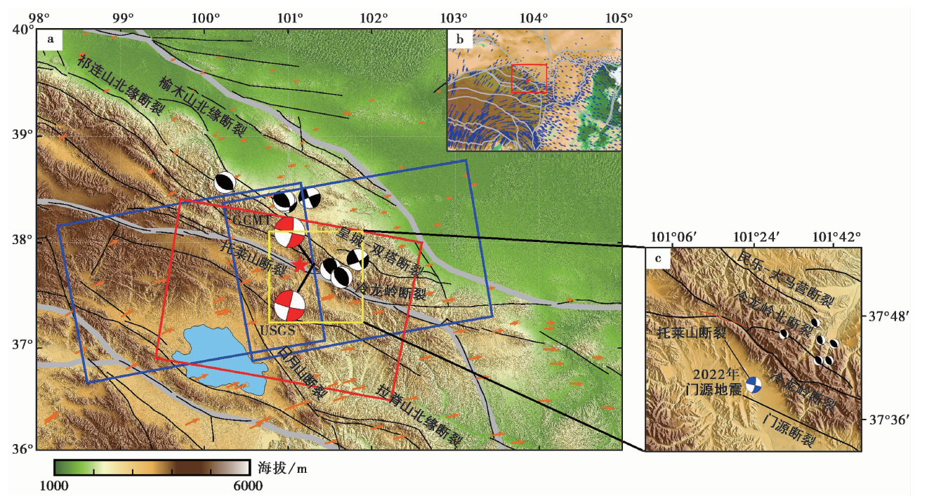
图1 地震地质构造背景图 a 蓝色矩形从左至右分别代表T26和T128升轨覆盖范围, 红色矩形代表T33降轨覆盖范围。红色震源机制解分别由GCMT、 USGS提供; 黑色震源球表示部分历史地震的震源机制解(MW≥5), 来自USGS(19902022年); 红色五角星表示CENC提供的地表震中位置; 黑色实线表示活动断裂; 灰色实线表示二级构造块体(张国民等, 2005); 橘黄色箭头表示地表GPS速度场(Wang et al., 2020)。b 大尺度上的震中地理空间位置。c小比例尺的震中地理空间位置; 红色虚线为地表破裂带
Fig. 1 Seismic geological structure background map.
| 轨道方向 (轨道号) | 成像日期 | 极化 方式 | 视线方位角α /(°) | 视线入射角θ /(°) | 空间基线 /m | 时间基线 /d | |
|---|---|---|---|---|---|---|---|
| 震前 | 震后 | ||||||
| 升轨(T26) | 2021-12-29 | 2022-01-10 | VV | -13.218 | 34.242 | -110.341 | 12 |
| 升轨(T128) | 2022-01-05 | 2022-01-17 | VV | -13.237 | 34.096 | 38.432 | 12 |
| 降轨(T33) | 2021-12-29 | 2022-01-10 | VV | -166.776 | 34.003 | 55.852 | 12 |
表2 升、 降轨差分干涉影像参数
Table2 Parameters of ascending and descending scenes
| 轨道方向 (轨道号) | 成像日期 | 极化 方式 | 视线方位角α /(°) | 视线入射角θ /(°) | 空间基线 /m | 时间基线 /d | |
|---|---|---|---|---|---|---|---|
| 震前 | 震后 | ||||||
| 升轨(T26) | 2021-12-29 | 2022-01-10 | VV | -13.218 | 34.242 | -110.341 | 12 |
| 升轨(T128) | 2022-01-05 | 2022-01-17 | VV | -13.237 | 34.096 | 38.432 | 12 |
| 降轨(T33) | 2021-12-29 | 2022-01-10 | VV | -166.776 | 34.003 | 55.852 | 12 |
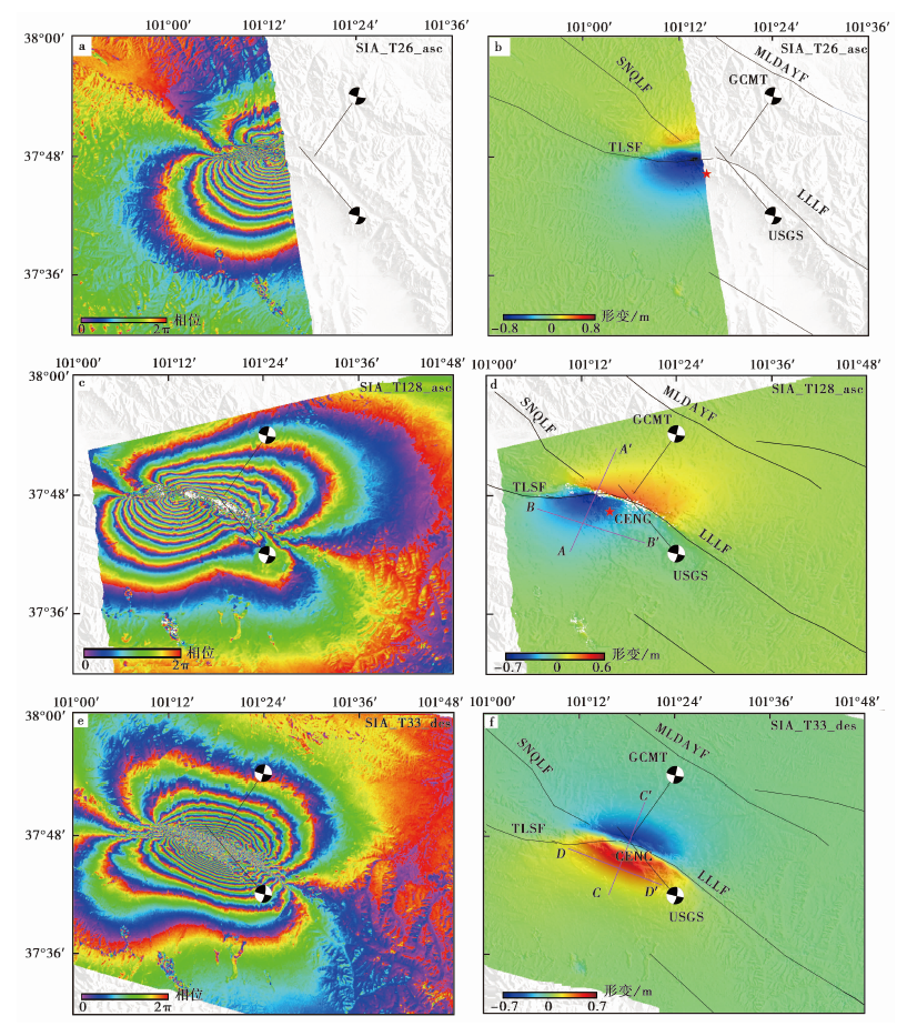
图2 同震干涉条纹图和形变场图(靠近卫星视线向为正) a、 c 升轨干涉条纹图; b、 d 升轨干涉形变场; e 降轨干涉条纹图; f 降轨干涉形变场。图b、 d、 f中靠近卫星视线方向的位移场用暖色调表示, 远离卫星视线方向的位移场用冷色调表示; 红色五角星代表CENC发布的震中。MLDMYF 民乐-大马营断裂; SNQLF 肃南-祁连断裂俄堡段; TLSF 托勒山断裂; LLLF 冷龙岭断裂
Fig. 2 Coseismic interference fringe pattern and deformation field pattern(The LOS near the satellite is positive).
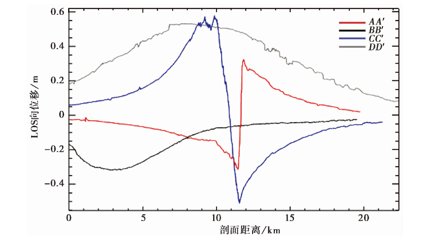
图3 不同观测模式下的2022年门源地震视线向形变场剖面图 红色和黑色实线为图2d的升轨形变场剖面线AA'和BB'; 蓝色和灰色实线为图2f的降轨形变场剖面线CC'和DD'
Fig. 3 The line of sight(LOS)displacement profile of different observation modes of the 2022 Menyuan earthquake.
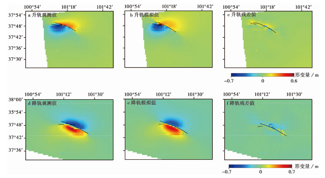
图4 InSAR升、 降轨约束反演获得的观测值、 模拟值和残差值图 、 b、 c分别为T128升轨形变、 模拟、 残差值; 图d、 e、 f分别为T33降轨形变、 模拟、 残差值。 图中靠近卫星视线方向的位移场(正值)用暖色调表示, 远离卫星视线方向的位移场(负值)用冷色调表示
图a Observed value, simulated value and residual value obtained by InSAR ascending orbit constraint inversion.
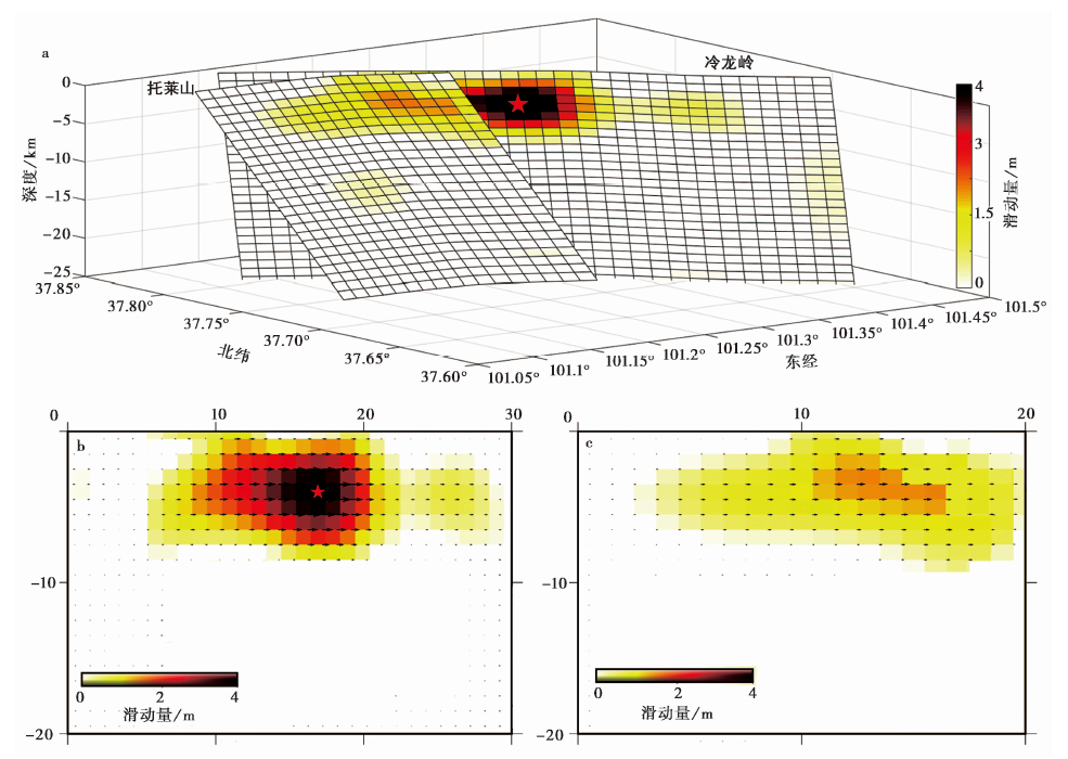
图5 2022年门源地震的同震滑动分布 a 三维精细滑动分布模型; b冷龙岭段精细滑动分布的地表投影; c 托莱山段精细滑动分布的地表投影
Fig. 5 Slip distributions of the 2022 Menyuan earthquake.
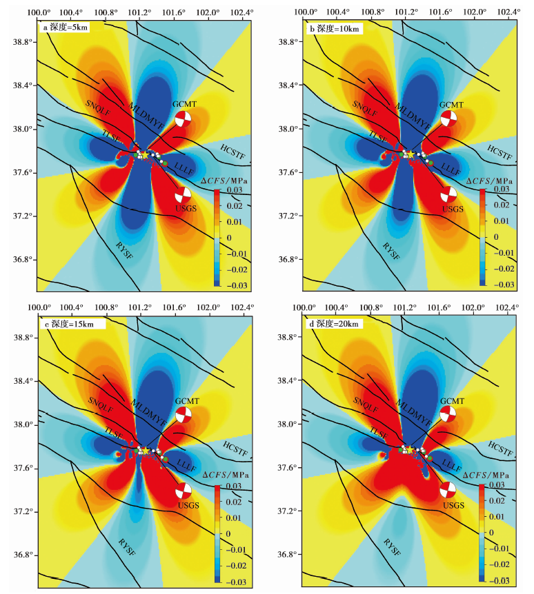
图6 门源地震引起的不同深度的库仑应力变化及后续地震分布 活动断层分布参考文献(邓起东等, 2003)绘制。红色圆点表示M>5余震, 绿色圆点表示M4~5余震, 白色圆点表示M3~4余震。MLDMYF 民乐-大马营断裂; HCSTF 皇城-双塔断裂; SNQLF 肃南-祁连断裂俄堡段; TLSF 托勒山 断裂; LLLF 冷龙岭断裂; RYSF 日月山断裂
Fig. 6 Coulomb stress variation at different depths and subsequent earthquake distribution caused by Menyuan earthquake.
| 断层 | 东经/(°) | 北纬/(°) | 长/km | 宽/km | 走向/(°) | 倾角/(°) | 滑动角/(°) |
|---|---|---|---|---|---|---|---|
| 托莱山断裂 | 101.27 | 37.8 | 100 | 30 | 109 | 58 | 21 |
| 肃南-祁连断裂俄堡段 | 101.22 | 37.81 | 70 | 30 | 290 | 58 | 21 |
| 冷龙岭断裂西段 | 101.30 | 37.8 | 140 | 30 | 125 | 50 | 21 |
表3 断层的几何参数
Table3 Fault geometric parameters
| 断层 | 东经/(°) | 北纬/(°) | 长/km | 宽/km | 走向/(°) | 倾角/(°) | 滑动角/(°) |
|---|---|---|---|---|---|---|---|
| 托莱山断裂 | 101.27 | 37.8 | 100 | 30 | 109 | 58 | 21 |
| 肃南-祁连断裂俄堡段 | 101.22 | 37.81 | 70 | 30 | 290 | 58 | 21 |
| 冷龙岭断裂西段 | 101.30 | 37.8 | 140 | 30 | 125 | 50 | 21 |
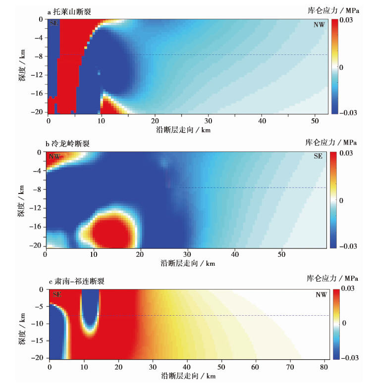
图7 门源地震不同接收断层上的库仑应力变化
Fig. 7 Coulomb stress variation on different receiving faults associated with the Menyuan earthquake.
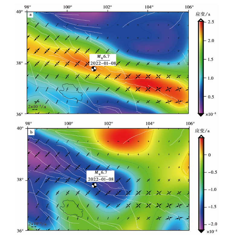
图8 2022年门源地震前的区域地壳应变率场 a 主应变率、 剪应变率场; b 面应变率场、 主压应力图
Fig. 8 Regional crustal strain rate field before the 2022 Menyuan earthquake.
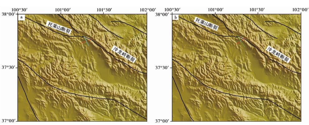
图9 2022年门源地震前后的区域构造应变场反演结果 、 b分别为历史和现今应力场反演的3个轴的水平投影; 红线代表主压应力轴, 绿线代表主张应力轴, 蓝线代表中间应力轴方向
图a Inversion results of regional tectonic strain field before and after the 2022 Menyuan earthquake.
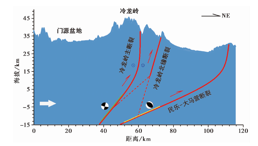
图10 2022年与2016年门源地震的空间位置关系图 白色箭头为青藏高原的推挤方向, 绿色实线是2022年门源地震的破裂区域, 黄色实线是2016年门源地震的破裂区域, 震源机制参数引自文献(郑博文, 2017)
Fig. 10 Map of spatial location of Menyuan earthquake in 2022 and 2016.
| [1] | 陈文彬. 2003. 河西走廊及邻近地区最新构造变形基本特征及构造成因分析[D]. 北京: 中国地震局地质研究所:3545. |
| CHEN Wen-bin. 2003. Principal features of tectonic deformation and their generation mechanism in the Hexi Corridor and its adjacent regions since Late Quaternary[D]. Institute of Geology, China Earthquake Administration, Beijing: 3545. (in Chinese) | |
| [2] | 邓起东, 张培震, 冉勇康, 等. 2003. 中国活动构造与地震活动[J]. 地学前缘, 10(S1): 6673. |
| DENG Qi-dong, ZHANG Pei-zhen, RAN Yong-kang, et al. 2003. Active tectonics and seismicity in China[J]. Earth Science Frontiers, 10(S1): 6673. (in Chinese) | |
| [3] | 何文贵, 刘百篪, 袁道阳, 等. 2000. 冷龙岭活动断裂的滑动速率研究[J]. 西北地震学报, 22(1): 9097. |
| HE Wen-gui, LIU Bai-chi, YUAN Dao-yang, et al. 2000. Research on slip rates of the Lenglongling active fault zone[J]. Northwestern Seismological Journal, 22(1): 9097. (in Chinese) | |
| [4] | 何文贵, 刘百篪, 袁道阳, 等. 2001. 冷龙岭断裂古地震初步研究[G]∥《活动断裂研究》编委会. 活动断裂研究(8). 北京: 地震出版社: 6473. |
| HE Wen-gui, LIU Bai-chi, YUAN Dao-yang, et al. 2001. Preliminary study on paleoearthquakes in Lenglongling Fault[G]∥ Editorial Committee of Active Faults Research(8). Seismological Press, Beijing: 6474. (in Chinese) | |
| [5] | 何文贵, 袁道阳, 葛伟鹏, 等. 2010. 祁连山活动断裂带中东段冷龙岭断裂滑动速率的精确厘定[J]. 地震, 30(1): 131137. |
| HE Wen-gui, YUAN Dao-yang, GE Wei-peng, et al. 2010. Determination of the slip rate of the Lenglongling Fault in the middle and eastern segments of the Qilian Mountain active fault zone[J]. Earthquake, 30(1): 131137. (in Chinese) | |
| [6] | 侯康明. 1998. 皇城-双塔断裂带的几何分段及运动学特征[J]. 华南地震, 18(3): 2834. |
| HOH Kang-ming. 1998. The geometric segmentation and kinematics characteristics of Huangcheng-Shuangta fault zone[J]. South China Journal of Seismology, 18(3): 2834. (in Chinese) | |
| [7] | 胡朝忠, 杨攀新, 李智敏, 等. 2016. 2016年1月21日青海门源6.4级地震的发震机制探讨[J]. 地球物理学报, 59(5): 16371646. |
| HU Chao-zhong, YANG Pan-xin, LI Zhi-min, et al. 2016. Seismogenic mechanism of the 21 January 2016 Menyuan, Qinghai MS6. 4 earthquake[J]. Chinses Journal of Geophysics, 59(5): 16371646. (in Chinese) | |
| [8] | 姜文亮. 2018. 冷龙岭断裂带全新世破裂模式、 大震复发特征研究及其区域构造意义[D]. 北京: 中国地震局地质研究所:3540. |
| JIANG Wen-liang. 2018. Holocene rupture pattern, seismic recurrence feature of the Lenglongling fault zone and its tectonic implication for the northeast Tibetan plateau[D]. Institute of Geology, China Earthquake Administration, Beijing: 3540. (in Chinese) | |
| [9] | 李振洪, 韩炳权, 刘振江, 等. 2022. InSAR数据约束下2016年和2022年青海门源地震震源参数及其滑动分布[J]. 武汉大学学报(信息科学版), 47(6): 887897. |
| LI Zhen-hong, HAN Bing-quan, LIU Zhen-jiang, et al. 2022. Source parameters and slip distributions of the 2016 and 2022 Menyuan, Qinghai earthquakes constrained by InSAR observations[J]. Geomatics and Information Science of Wuhan University, 47(6): 887897. (in Chinese) | |
| [10] | 李智敏, 盖海龙, 李鑫, 等. 2022. 2022年青海门源 MS6.9 地震发震构造和地表破裂初步调查[J]. 地质学报, 96(1): 330335. |
| LI Zhi-min, GAI Hai-long, LI Xin, et al. 2022. Seismogenic fault and coseismic surface deformation of the Menyuan MS6.9 earthquake in Qinghai, China[J]. Acta Geologica Sinica, 96(1): 330335. (in Chinese) | |
| [11] | 潘家伟, 李海兵, Chevalier M, 等. 2022. 2022年青海门源 MS6.9 地震地表破裂带及发震构造研究[J]. 地质学报, 96(1): 215231. |
| PAN Jia-wei, LI Hai-bing, Chevalierr M, et al. 2022. Coseismic surface rupture and seismogenic structure of the 2022 MS6.9 Menyuan earthquake, Qinghai Province, China[J]. Acta Geologica Sinica, 96(1): 215231. (in Chinese) | |
| [12] | 万永革. 2001. “地震静态应力触发”问题的研究[D]. 北京: 中国地震局地球物理研究所:710. |
| WAN Yong-ge. 2001. Study on seismic static stress triggering problem[D]. Institute of Geophysics, China Earthquake Administration, Beijing: 710. (in Chinese) | |
| [13] | 王琼, 肖卓, 武粤, 等. 2022. 2022年1月8日青海门源 MS6.9 地震深部构造背景浅析[J]. 地震学报, 44(2): 211222. |
| WANG Qiong, XIAO Zhuo, WU Yue, et al. 2022. The deep tectonic background of the MS6.9 Menyuan earthquake on January 8, 2022 in Qinghai Province[J]. Acta Seismologica Sinica, 44(2): 211222. (in Chinese) | |
| [14] | 张国民, 马宏生, 王辉, 等. 2005. 中国大陆活动地块边界带与强震活动. 地球物理学报, 48(3): 602610. |
|
ZHANG Guo-min, MA Hong-sheng, WANG hui, et al. 2005. Boundaries between active tectonic blocks and strong earthquakes in the China mainland[J]. Chinese Journal of Geophysics, 48(3): 602610. (in Chinese)
DOI URL |
|
| [15] | 颜丙囤, 季灵运, 蒋锋云, 等. 2022. InSAR数据约束的2022年1月8日青海门源 MS6.9 地震发震构造研究[J]. 地震工程学报, 44(2): 450457. |
| YAN Bing-tun, JI Ling-yun, JIANG Feng-yun, et al. 2022. Seismogenic structure of Menyuan, Qinghai MS6.9 earthquake on January 8, 2022 constrained by InSAR data[J]. China Earthquake Engineering Journal, 44(2): 450457. (in Chinese) | |
| [16] | 余鹏飞, 陈威, 乔学军, 等. 2022. 基于多源SAR数据的2022年门源 MS6.9 地震同震破裂模型反演研究[J]. 武汉大学学报(信息科学版), 47(6): 898906. |
| YU Peng-fei, CHEN Wei, QIAO Xue-jun, et al. 2022. Slip model of the 2022 Menyuan MS6.9 earthquake constrained by multi-source SAR data[J]. Geomatics and Information Science of Wuhan University, 47(6): 898906. (in Chinese) | |
| [17] | 郑博文. 2017. 2016年门源地震InSAR形变场及发震断层参数反演[D]. 北京: 中国地震局地质研究所:2630. |
| ZHENG Bo-wen. 2017. InSAR deformation field and inversion of causative fault parameters for the 2016 Menyuan earthquake[D]. Institute of Geology, China Earthquake Administration, Beijing: 2630. (in Chinese) | |
| [18] |
Daout S, Jolivet R, Lasserre C, et al. 2016. Along-strike variations of the partitioning of convergence across the Haiyuan fault system detected by InSAR[J]. Geophysical Journal International, 205(1): 536547.
DOI URL |
| [19] | Farr T G, Rosen P A, Caro E, et al. 2007. The shuttle radar topography mission[J]. Reviews of Geophysics. 45(2): 133. |
| [20] |
Gaudemer Y, Tapponnier P, Meyer B, et al. 1995. Partitioning of crustal slip between linked, active faults in the eastern Qilian Shan, and evidence for a major seismic gap, the “Tianzhu gap”, on the western Haiyuan Fault, Gansu(China)[J]. Geophysical Journal International, 120(3): 599645.
DOI URL |
| [21] |
Goldstein R M, Werner C L. 1998. Radar interferogram filtering for geophysical applications[J]. Geophysical Research Letters, 25(21): 40354038.
DOI URL |
| [22] | Lasserre C, Gaudmer Y, Tapponnier P, et al. 2002. Fast late Pleistocene slip rate on the Leng Long Ling segment of the Haiyuan Fault, Qinghai, China[J]. Journal of Geophysical Research, 107(B11): 115. |
| [23] | Lin J, Ross S. 2004. Stress triggering in thrust and subduction earthquakes and stress interaction between the southern San Andreas and nearby thrust and strike-slip faults[J]. Journal of Geophysical Research: Solid Earth, 109(B2): 119. |
| [24] | Lohman R B, Simons M. 2005. Some thoughts on the use of InSAR data to constrain models of surface deformation: Noise structure and data downsampling[J]. Geochem Geophys Geosystems, 6(1): 359361. |
| [25] |
Okada Y. 1985. Surface deformation due to shear and tensile faults in a half-space[J]. Bulletin of the Seismological Society of America, 75(4): 11351154.
DOI URL |
| [26] |
Savage J C, Gan W, Svarc J L. 2001. Strain accumulation and rotation in the eastern California shear zone[J]. Journal of Geophysical Research, 106(B10): 2199522007.
DOI URL |
| [27] | Toda S, Stein R S, Richards-Dinger K, et al. 2005. Forecasting the evolution of seismicity in southern California: Animations built on earthquake stress transfer[J]. Journal of Geophysical Research: Solid Earth, 110(B5): B05S16. |
| [28] | Wang M, Shen Z K. 2020. Present-day crustal deformation of continental China derived from GPS and its tectonic implications[J]. Journal of Geophysical Research: Solid Earth, 125(2): e2019JB018774. |
| [29] |
Wang R, Parolai S, Ge M, et al. 2013. The 2011 MW9.0 Tohoku earthquake: Comparison of GPS and strong-motion data[J]. Bulletin of the Seismological Society of America, 103(2B): 13361347.
DOI URL |
| [30] | Werner C, Wegmüller U, Strozzi T, et al. 2002. Processing strategies for phase unwrapping for InSAR applications[J]. Proceedings EUSAR 2002, Cologne, 1: 46. |
| [31] |
Wu Y, Jiang Z, Yang G, et al. 2011. Comparison of GPS strain rate computing methods and their reliability[J]. Geophysical Journal International, 185(2): 703717.
DOI URL |
| [32] | Ziv A, Rubin A M. 2000. Static stress transfer and earthquake triggering: No lower threshold in sight[J]. Journal of Geophysical Research(Solid Earth), 105(B6): 1363113642. |
| [1] | 李岩, 陈俊磊, 吕思宇, 王宇栋, 傅磊. 景谷地震序列触发关系及应力场反演[J]. 地震地质, 2026, 48(2): 561-581. |
| [2] | 黄婷, 吴芳, 夏彩香, 李振宏, 董晓朋, 吴中海, 寇琳琳. 宁夏清水河盆地南部全新世灾变事件层特征及其与区域地震的关系[J]. 地震地质, 2025, 47(4): 1036-1057. |
| [3] | 唐茂云, 李翠平, 黄世源, 董蕾, 高见, 李勇. 泸县—荣昌地区地震活动时空演化与构造应力场特征[J]. 地震地质, 2025, 47(4): 1183-1203. |
| [4] | 杨九元, 温扬茂, 许才军, 杨见兵. 同震及震后形变约束的2020年3月青藏高原南部定日 MW5.7 地震发震构造[J]. 地震地质, 2025, 47(4): 1292-1305. |
| [5] | 王度, 陈立春, 李彦宝, 王虎, 贾永顺, 高茵怡, 薛柯依. 藏南申扎-定结裂谷系谢通门-登么错段晚第四纪活动特征[J]. 地震地质, 2025, 47(3): 718-733. |
| [6] | 杨文心, 李涛, 陈杰, 姚远. 2015年西昆仑山前皮山MW6.4地震的构造背景及意义[J]. 地震地质, 2025, 47(2): 507-532. |
| [7] | 盛书中, 王倩茹, 李振月, 李红星, 张小娟, 葛坤朋, 宫猛. 基于构造应力场研究2025年西藏定日6.8级地震的发震构造[J]. 地震地质, 2025, 47(1): 49-63. |
| [8] | 曹筠, 周依, 高晨, 刘书峰, 陈安, 张素欣, 冯向东, 吴鹏, 陈肇东. 2020年7月12日河北唐山5.1级地震发震断层判定及其区域构造意义[J]. 地震地质, 2024, 46(5): 993-1011. |
| [9] | 李抒予, 高原, 金红林, 刘同振. 青藏高原东北部上地壳剪切波分裂特征[J]. 地震地质, 2024, 46(4): 916-933. |
| [10] | 许英才, 郭祥云. 2022年四川马尔康MS6.0强震群重定位及发震断层探讨[J]. 地震地质, 2023, 45(4): 1006-1024. |
| [11] | 李丹丹, 唐新功, 熊治涛. 青藏高原东缘地壳密度结构及其地球动力学意义[J]. 地震地质, 2023, 45(4): 936-951. |
| [12] | 王辽, 谢虹, 袁道阳, 李智敏, 薛善余, 苏瑞欢, 文亚猛, 苏琦. 结合野外考察的2022年门源MS6.9地震地表破裂带的高分七号影像特征[J]. 地震地质, 2023, 45(2): 401-421. |
| [13] | 吴中海, 白玛多吉, 叶强, 韩帅, 史亚然, 尼玛次仁, 高扬. 西藏阿里阿鲁错地堑系的第四纪活动性、最新同震地表破裂及其地震地质意义[J]. 地震地质, 2023, 45(1): 67-91. |
| [14] | 宋婷, 沈旭章, 梅秀苹, 焦煜媛, 李敏娟, 苏小芸, 季婉婧. 利用接收函数频率特征研究青藏高原东北缘地区的莫霍面性质[J]. 地震地质, 2022, 44(5): 1290-1312. |
| [15] | 李宗旭, 贺日政, 冀战波, 李娱兰, 牛潇. 2009年7月24日西藏尼玛MS5.6地震的震源机制及其构造意义[J]. 地震地质, 2022, 44(4): 992-1010. |
| 阅读次数 | ||||||
|
全文 |
|
|||||
|
摘要 |
|
|||||
