地震地质 ›› 2023, Vol. 45 ›› Issue (4): 936-951.DOI: 10.3969/j.issn.0253-4967.2023.04.008
李丹丹1,2)( ), 唐新功1),*(), 熊治涛1,3)
收稿日期:2022-11-19
修回日期:2023-02-15
出版日期:2023-08-20
发布日期:2023-09-20
通讯作者:
*唐新功, 男, 1968年生, 博士, 教授, 博士生导师, 主要研究方向为电磁法勘探、 重力勘探与地球动力学, E-mail: 作者简介:基金资助:
LI Dan-dan1,2)(), TANG Xin-gong1),*(), XIONG Zhi-tao1,3)
Received:2022-11-19
Revised:2023-02-15
Online:2023-08-20
Published:2023-09-20
摘要:
青藏高原东缘是高原物质向E及SE扩展的重要通道, 掌握青藏高原东缘的地壳密度结构对研究青藏高原的隆升、 变形机制具有重要意义。文中在前人研究成果的基础上, 选取了地面实测的9条交叉的重力测线数据, 以深地震反射剖面为约束, 采用人机交互模式反演得到了青藏高原东缘地下的二维密度结构, 并通过克里金插值法获取了三维密度结果。反演结果表明, 青藏高原东缘地区具有巨厚的地壳, 莫霍面埋深最深约为61km, 而四川盆地的莫霍面埋深约为42km, 以龙门山-安宁河-小金河断裂为界, 两侧形成了莫霍面深度变化梯度带; 从反演得到的沉积层厚度来看, 沉积层在青藏高原东缘几个块体内呈现中心普遍厚度较大、 边缘厚度较薄的特点。结合该地区的地震空间分布特征分析, 青藏高原东缘的莫霍面和沉积层厚度分布与该地区的地震分布均具有很强的相关性, 这对未来地震预测也具有重要的参考价值。
李丹丹, 唐新功, 熊治涛. 青藏高原东缘地壳密度结构及其地球动力学意义[J]. 地震地质, 2023, 45(4): 936-951.
LI Dan-dan, TANG Xin-gong, XIONG Zhi-tao. CRUSTAL DENSITY STRUCTURE OF THE EASTERN TIBETAN PLATEAU AND ITS GEODYNAMIC IMPLICATIONS[J]. SEISMOLOGY AND GEOLOGY, 2023, 45(4): 936-951.
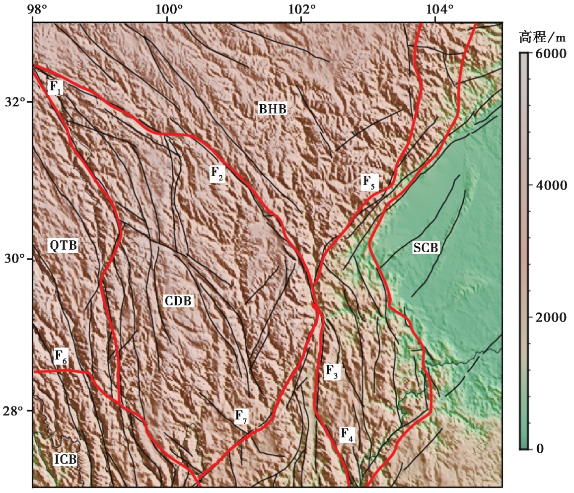
图 1 青藏高原东缘的构造块体和断裂带 地形数据来自文献(Amante et al., 2008); 黑色实线为断层分布(邓起东, 2007); 块体划分来自文献(玄松柏, 2016)。ICB 印支块体; BHB 巴颜喀拉块体; CDB 川滇菱形块体; SCB 四川盆地; QTB 羌塘块体。F1 甘孜-玉树断裂带; F2 鲜水河断裂带; F3 安宁河断裂带; F4 则木河断裂带; F5 龙门山断裂带; F6 怒江断裂带; F7 小金河断裂带
Fig. 1 Tectonic blocks and fault zones in the eastern margin of the Tibetan plateau.
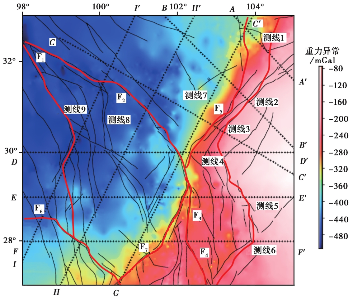
图 2 青藏高原东缘重力测线分布及布格重力异常图
Fig. 2 Bouguer gravity anomaly map with the survey lines in the eastern margin of the Tibetan plateau.
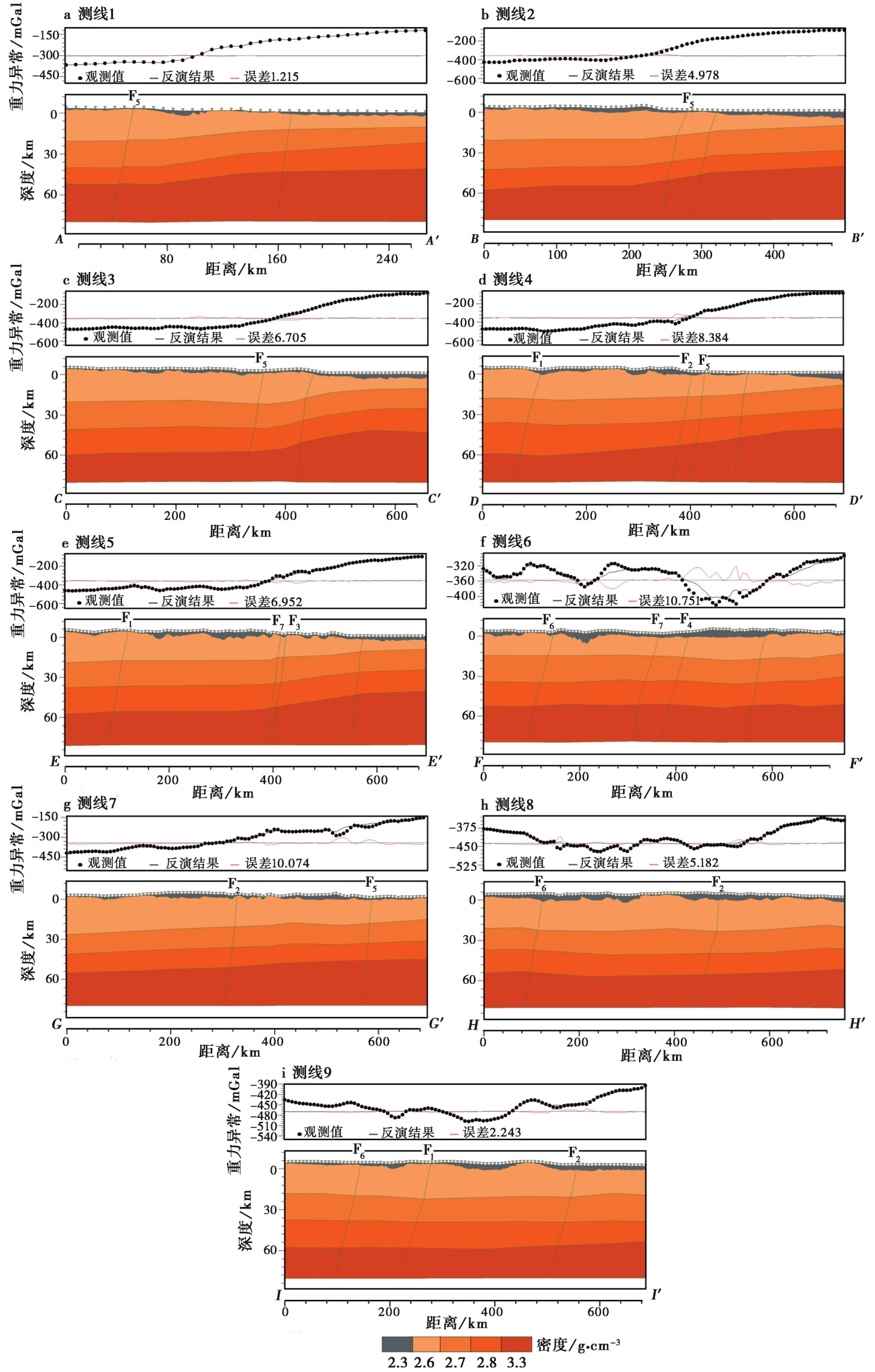
图 3 二维重力反演结果剖面图 a 测线1; b 测线2; c 测线3; d 测线4; e 测线5; f 测线6; g 测线7; h 测线8; i 测线9
Fig. 3 2D gravity inversion profile of the survey lines.
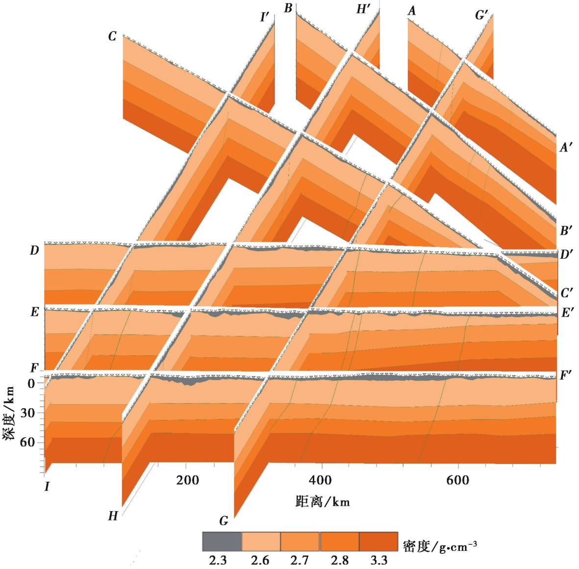
图 4 三维多剖面组合图
Fig. 4 Combined 3D plot of multi-profiles.
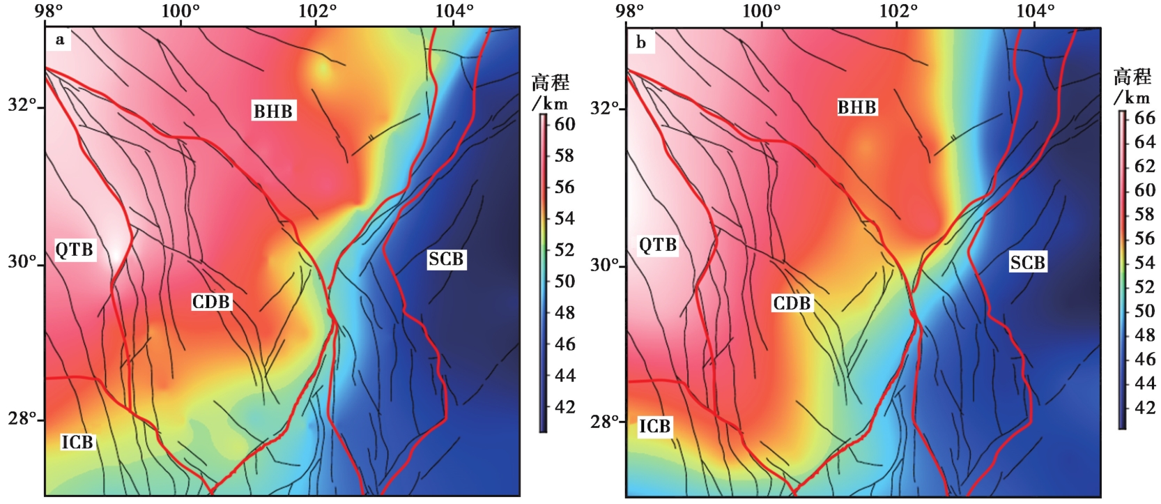
图 5 通过重力反演得到的青藏高原东缘莫霍面深度分布(a)和CRUST 1.0(Laske et al., 2012)莫霍面深度分布图(b)
Fig. 5 Maps showing the Moho depth by gravity inverted(a)and CRUST 1.0(Laske et al., 2012)(b)in the eastern margin of the Tibetan plateau.
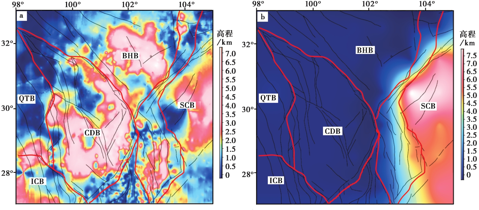
图 6 通过重力反演得到的青藏高原东缘沉积层厚度分布(a)和CRUST1.0(Laske et al., 2012)沉积层厚度分布图(b)
Fig. 6 Maps showing sediment thickness by gravity inverted(a)and CRUST1.0(Laske et al., 2012)(b)in the eastern margin of the Tibetan plateau.
| 编号 | 拟合标准差/mGal | 平均拟合标准差/mGal |
|---|---|---|
| 测线1 | 1.215 | 6.297 |
| 测线2 | 4.978 | |
| 测线3 | 6.705 | |
| 测线4 | 8.384 | |
| 测线5 | 6.952 | |
| 测线6 | 10.937 | |
| 测线7 | 10.074 | |
| 测线8 | 5.182 | |
| 测线9 | 2.243 |
表 1 测线1-9的拟合标准误差
Table 1 Fitting standard error of Line 1-9
| 编号 | 拟合标准差/mGal | 平均拟合标准差/mGal |
|---|---|---|
| 测线1 | 1.215 | 6.297 |
| 测线2 | 4.978 | |
| 测线3 | 6.705 | |
| 测线4 | 8.384 | |
| 测线5 | 6.952 | |
| 测线6 | 10.937 | |
| 测线7 | 10.074 | |
| 测线8 | 5.182 | |
| 测线9 | 2.243 |
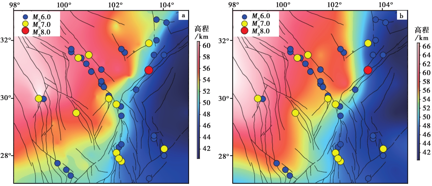
图 7 青藏高原东缘地区重力反演(a)和CRUST 1.0(Laske et al., 2012)莫霍面深度(b)及青藏高原东缘6级以上地震分布图 地震数据来自美国国家海洋和大气管理局国家地球物理数据中心①(①https://www.ngdc.noaa.gov/hazel/view/hazards/earthquake/search。)
Fig. 7 Distribution MS≥6 earthquakes and the Moho depth by gravity inverted(a)and CRUST 1.0(Laske et al., 2012)(b)in the eastern margin of the Tibetan plateau.
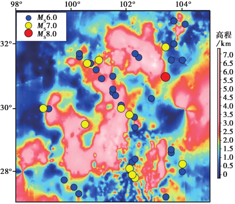
图 8 反演得到的青藏高原东缘沉积层厚度及该地区6级及以上历史地震分布图
Fig. 8 The thickness of sediment and distribution of earthquakes MS≥6 in the eastern the Tibetan plateau.
| [1] |
陈石, 王谦身, 祝意青, 等. 2011. 青藏高原东缘重力导纳模型均衡异常时空特征[J]. 地球物理学报, 54(1): 22-34.
|
|
|
|
| [2] |
陈石, 王青华, 王谦身, 等. 2014. 云南鲁甸 MS6.5 地震震源区和周边三维密度结构及重力场变化[J]. 地球物理学报, 57(9): 3080-3090.
|
|
|
|
| [3] |
崔作舟, 卢德源, 陈纪平, 等. 1987. 攀西地区的深部地壳结构与构造[J]. 地球物理学报, 30(6): 566-580.
|
|
|
|
| [4] |
邓起东. 2007. 中国活动构造图(1︰400万)[CM]. 北京: 地震出版社.
|
|
|
|
| [5] |
段永红, 张先康, 杨卓欣. 2002. 帕米尔东北侧基底结构研究[J]. 地震学报, 24(4): 378-384.
|
|
|
|
| [6] |
冯锐. 1985. 中国地壳厚度及上地幔密度分布三维重力反演结果[J]. 地震学报, 7(2): 143-157.
|
|
|
|
| [7] |
高锐, 马永生, 李秋生, 等. 2006. 松潘地块与西秦岭造山带下地壳的性质和关系: 深地震反射剖面的揭露[J]. 地质通报, 25(12): 1361-1367.
|
|
|
|
| [8] |
高锐, 熊小松, 李秋生, 等. 2009. 由地震探测揭示的青藏高原莫霍面深度[J]. 地球学报, 30(6): 761-773.
|
|
|
|
| [9] |
郭文斌, 嘉世旭, 段永红, 等. 2016. 青藏高原东北缘基底结构研究: 玛多-共和-雅布赖剖面上地壳地震折射探测[J]. 地球物理学报, 59(10): 3627-3636.
|
|
|
|
| [10] |
郭晓玉, 高锐,
|
|
|
|
| [11] |
胡丰产, 蔺佳斌, 赵诚亮, 等. 2012. 地磁2.5D剖面反演在西藏某磁铁矿区的应用解释[J]. 工程地球物理学报, 9(1): 58-63.
|
|
|
|
| [12] |
嘉世旭, 刘昌铨. 1991. 华北裂谷盆地南部菏泽-长治地震测深剖面结果解释[J]. 华北地震科学, 9(2): 11-20.
|
|
|
|
| [13] |
嘉世旭, 张先康, 赵金仁, 等. 2009. 若尔盖盆地及周缘褶皱造山带地壳结构: 深地震测深结果[J]. 中国科学(D辑), 39(9): 1200-1208.
|
|
|
|
| [14] |
蒋福珍. 2002. 三江地区重力场特征和岩石圈构造[J]. 武汉大学学报(信息科学版), 27(2): 122-126.
|
|
|
|
| [15] |
黎源, 雷建设. 2012. 青藏高原东缘上地幔顶部Pn波速度结构及各向异性研究[J]. 地球物理学报, 55(11): 3615-3624.
|
|
|
|
| [16] |
刘启元, 李昱, 陈九辉, 等. 2009. 汶川 MS8.0 地震: 地壳上地幔S波速度结构的初步研究[J]. 地球物理学报, 52(2): 309-319.
|
|
|
|
| [17] |
申重阳, 杨光亮, 谈洪波, 等. 2015. 维西-贵阳剖面重力异常与地壳密度结构特征[J]. 地球物理学报, 58(11): 3952-3964.
|
|
|
|
| [18] |
孙洁, 晋光文, 白登海, 等. 2003. 青藏高原东缘地壳-上地幔电性结构探测及其构造意义[J]. 中国科学(D辑), 33(S1): 173-181.
|
|
|
|
| [19] |
唐新功, 尤双双, 胡文宝, 等. 2012. 龙门山断裂带地壳密度结构[J]. 地震地质, 34(1): 28-38. doi: 10.3969/j.issn.0253-4967.2012.01.004.
DOI |
|
|
|
| [20] |
唐新功, 张锐锋, 万伟, 等. 2017. 三维高精度重力方法在深部潜山勘探中的应用[J]. 地震地质, 39(4): 712-720. doi: 10.3969/j.issn.0253-4967.2017.04.007.
DOI |
|
|
|
| [21] |
王椿镛, 韩渭宾, 吴建平, 等. 2003a. 松潘-甘孜造山带地壳速度结构[J]. 地震学报, 25(3): 229-241.
|
|
|
|
| [22] |
王椿镛, 吴建平, 楼海, 等. 2003b. 川西藏东地区的地壳P波速度结构[J]. 中国科学(D辑), 33(S1): 181-189.
|
|
|
|
| [23] |
王谦身, 滕吉文, 张永谦, 等. 2008. 龙门山断裂系及邻区地壳重力均衡效应与汶川地震[J]. 地球物理学进展, 23(6): 1664-1670.
|
|
|
|
| [24] |
王伟君. 2012. 利用地震噪声调查华北平原场地作用和浅层结构[D]. 合肥: 中国科学技术大学:71.
|
|
|
|
| [25] |
王有学,
|
|
|
|
| [26] |
熊绍柏, 郑晔, 尹周勋, 等. 1993. 丽江-攀枝花-者海地带二维地壳结构及其构造意义[J]. 地球物理学报, 36(4): 434-444.
|
|
|
|
| [27] |
玄松柏. 2016. 青藏高原东缘地壳结构与物质运移的重力研究[D]. 武汉: 武汉大学:12.
|
|
|
|
| [28] |
杨光亮, 申重阳, 吴桂桔, 等. 2015. 金川-芦山-犍为剖面重力异常和地壳密度结构特征[J]. 地球物理学报, 58(7): 2424-2435.
|
|
|
|
| [29] |
杨志高, 陈运泰, 张雪梅, 等. 2019. 青藏高原东缘及东北缘S波速度结构和径向各向异性[J]. 地球物理学报, 62(12): 4554-4570.
|
|
|
|
| [30] |
张先康, 嘉世旭, 赵金仁, 等. 2008. 西秦岭-东昆仑及邻近地区地壳结构: 深地震宽角反射/折射剖面结果[J]. 地球物理学报, 51(2): 439-450.
|
|
|
|
| [31] |
张先康, 杨卓欣, 徐朝繁, 等. 2007. 阿尼玛卿缝合带东段上地壳结构: 马尔康-碌曲-古浪深地震测深剖面结果[J]. 地震学报, 29(6): 592-604.
|
|
|
|
| [32] |
朱思林, 甘家思, 徐菊生, 等. 1994. 滇西试验场区三维重力反演研究[J]. 地壳变形与地震, 14(1): 1-10.
|
|
|
|
| [33] |
朱岳清. 1984. 重力异常、 莫霍面变形与唐山地震的孕育过程[J]. 地震, (3): 31-37.
|
|
|
|
| [34] |
|
| [35] |
DOI URL |
| [36] |
DOI URL |
| [37] |
DOI URL |
| [38] |
|
| [39] |
|
| [40] |
DOI URL |
| [41] |
DOI URL |
| [42] |
PMID |
| [43] |
DOI URL |
| [44] |
DOI URL |
| [45] |
DOI URL |
| [46] |
PMID |
| [47] |
DOI URL |
| [48] |
|
| [49] |
DOI URL |
| [50] |
DOI URL |
| [1] | 宋婷, 沈旭章, 梅秀苹, 焦煜媛, 李敏娟, 苏小芸, 季婉婧. 利用接收函数频率特征研究青藏高原东北缘地区的莫霍面性质[J]. 地震地质, 2022, 44(5): 1290-1312. |
| [2] | 宗健业, 孙新蕾, 张鹏. 利用HVSR方法研究广州地区的场地效应及估算地震灾害特征[J]. 地震地质, 2020, 42(3): 628-639. |
| [3] | 酆少英, 刘保金, 李倩, 袁洪克, 朱国军, 田一鸣, 王宏伟, 侯黎华, 邓小娟, 谭雅丽. 深地震反射剖面揭示的华北地块南缘地壳的精细结构[J]. 地震地质, 2020, 42(3): 581-594. |
| [4] | 汤井田, 杨磊, 任政勇, 胡双贵, 徐志敏. 龙门山断裂带卫星重力场特征及其发震机制[J]. 地震地质, 2019, 41(5): 1136-1154. |
| [5] | 徐志萍, 王夫运, 姜磊, 徐顺强, 唐淋. 川滇地区莫霍面深度和地壳厚度[J]. 地震地质, 2018, 40(6): 1318-1331. |
| [6] | 王鑫, 张景发, 姜文亮, 蒋洪波, 田甜, 高敏, 付萍杰. 郯庐断裂带南段重力异常及不同深度的横向构造特征[J]. 地震地质, 2016, 38(2): 370-385. |
| [7] | 谭锡斌, 李元希, 徐锡伟, 陈玟禹, 许冲, 于贵华. 低温热年代学数据对龙门山推覆构造带南段新生代构造活动的约束[J]. 地震地质, 2013, 35(3): 506-517. |
| [8] | 唐新功, 尤双双, 胡文宝, 严良俊. 龙门山断裂带地壳密度结构[J]. 地震地质, 2012, 34(1): 28-38. |
| 阅读次数 | ||||||
|
全文 |
|
|||||
|
摘要 |
|
|||||
