地震地质 ›› 2022, Vol. 44 ›› Issue (1): 205-219.DOI: 10.3969/j.issn.0253-4967.2022.01.013
李翠平( ), 唐茂云, 郭卫英, 王小龙, 董蕾
收稿日期:2021-01-15
修回日期:2021-06-09
出版日期:2022-02-20
发布日期:2022-04-20
作者简介:李翠平, 女, 1989年生, 2015年于中国地震局地质所获构造地貌学专业硕士学位, 工程师, 主要从事地震活动性与地震危险性研究, 电话: 023-67086623, E-mail: wulicuiping@126.com。
基金资助:
LI Cui-ping(), TANG Mao-yun, GUO Wei-ying, WANG Xiao-long, DONG Lei
Received:2021-01-15
Revised:2021-06-09
Online:2022-02-20
Published:2022-04-20
摘要:
文中基于2008年1月—2020年6月重庆区域固定台网、 流动台网及自贡地方台网记录的1 786个地震事件的P波和S波到时数据, 采用双差层析成像反演了荣昌及周边精细的三维P波速度结构和地震事件的重定位结果。研究结果显示, 荣昌地区沉积盖层与结晶基底的分界深度为12km, 华蓥山基底断裂东、 西两侧的速度结构在7~13km深度处差异较大, 与前人的研究结果和荣昌地区的地震反射剖面特征基本一致。上地壳浅表层P波速度结构横向差异变化较大, 在螺观山背斜轴部的螺2注水井附近为高速区, 分布深度为3~7km。地震重定位结果显示中等地震主要分布在高、 低速交界地区, 广顺横断层北侧的地震分布与螺2注水井附近的高速体展布一致, 均沿着螺观山北翼隐伏断层的倾向分布, 推测该断层是废水下渗的主要通道, 其下渗深度达7km。
中图分类号:
李翠平, 唐茂云, 郭卫英, 王小龙, 董蕾. 荣昌及周边三维速度结构初步研究[J]. 地震地质, 2022, 44(1): 205-219.
LI Cui-ping, TANG Mao-yun, GUO Wei-ying, WANG Xiao-long, DONG Lei. A PRELIMINARY STUDY ON 3D VELOCITY STRUCTURE OF RONGCHANG AND ITS ADJACENT AREA[J]. SEISMOLOGY AND EGOLOGY, 2022, 44(1): 205-219.
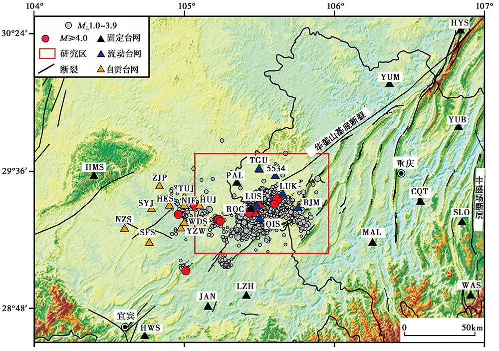
图 1 研究区台站、 历史震中分布图
Fig. 1 Seismic stations and historical earthquakes in the study area.
| 断层名称 | 简称 | 长度/km | 力学性质 | 走向 | 倾向 | 倾角 |
|---|---|---|---|---|---|---|
| 华蓥山断裂 | HYS | 600 | 逆冲右行走滑 | 50° | SE | 75° |
| 燕子岩断层 | YZY | 10 | 逆冲 | 60° | SE | 75° |
| 广顺横断层 | GSH | 29 | 正断右行走滑 | 315° | 不详 | 不详 |
| 黄泥垭断层 | HNY | 24 | 逆冲 | 220° | NW | 36°~54° |
| 薄刀岭断层 | BDL | 18 | 逆冲 | 240° | NW | 55° |
| 双河场断层 | SHC | 12 | 逆冲 | 40°~50° | SE | 30°~40° |
| 月琴坝断层 | YQB | 19 | 逆冲 | 225° | NW | 25°~67° |
| 螺观山南翼断层 | LGSS | 10 | 逆冲 | 45° | SE | 不详 |
| 螺观山北翼断层 | LGSN | 14 | 逆冲 | 225° | NW | 45° |
表1 荣昌及周边断裂性质
Table 1 The fault properties in the Rongchang and its adjacent areas
| 断层名称 | 简称 | 长度/km | 力学性质 | 走向 | 倾向 | 倾角 |
|---|---|---|---|---|---|---|
| 华蓥山断裂 | HYS | 600 | 逆冲右行走滑 | 50° | SE | 75° |
| 燕子岩断层 | YZY | 10 | 逆冲 | 60° | SE | 75° |
| 广顺横断层 | GSH | 29 | 正断右行走滑 | 315° | 不详 | 不详 |
| 黄泥垭断层 | HNY | 24 | 逆冲 | 220° | NW | 36°~54° |
| 薄刀岭断层 | BDL | 18 | 逆冲 | 240° | NW | 55° |
| 双河场断层 | SHC | 12 | 逆冲 | 40°~50° | SE | 30°~40° |
| 月琴坝断层 | YQB | 19 | 逆冲 | 225° | NW | 25°~67° |
| 螺观山南翼断层 | LGSS | 10 | 逆冲 | 45° | SE | 不详 |
| 螺观山北翼断层 | LGSN | 14 | 逆冲 | 225° | NW | 45° |
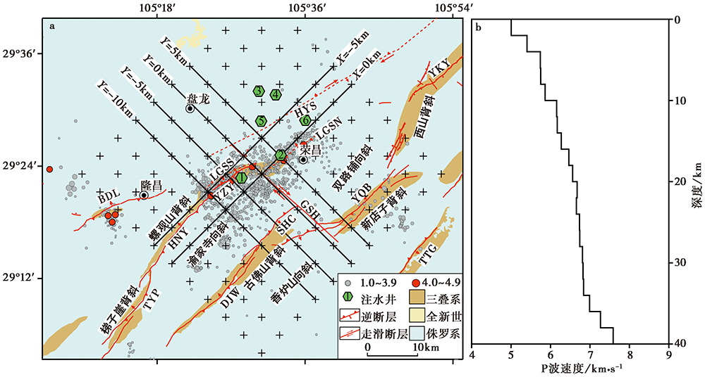
图 2 a 研究区断层、 注水井、 网格节点; b 初始一维速度模型 绿色六边形代表注水井, 六边形内的数字代表注水井编号, 其中注水井1螺4井, 2螺2井, 3包11井, 4包24井, 5包18井, 6 包23井(图7和图8相同)
Fig. 2 The distribution map of faults, injection wells and grid nodes(a) and initial 1D velocity model(b) in the study area.
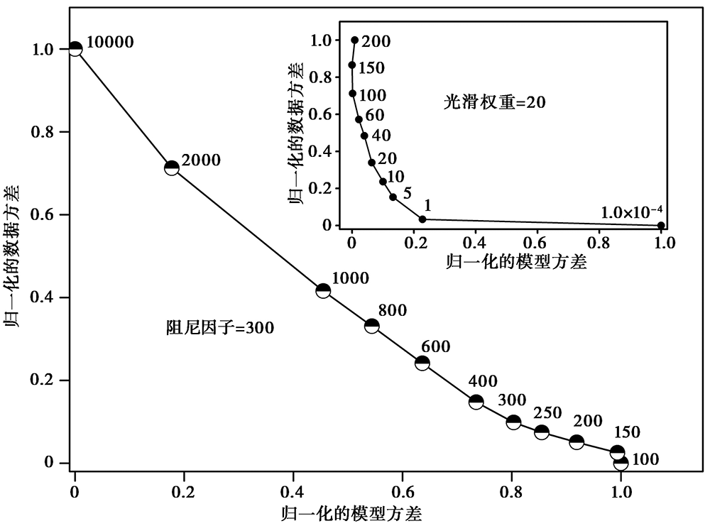
图 3 利用L曲线选择最佳的光滑权重和阻尼参数
Fig. 3 The best smoothing weight and damping parameters selected by trade-off curves.
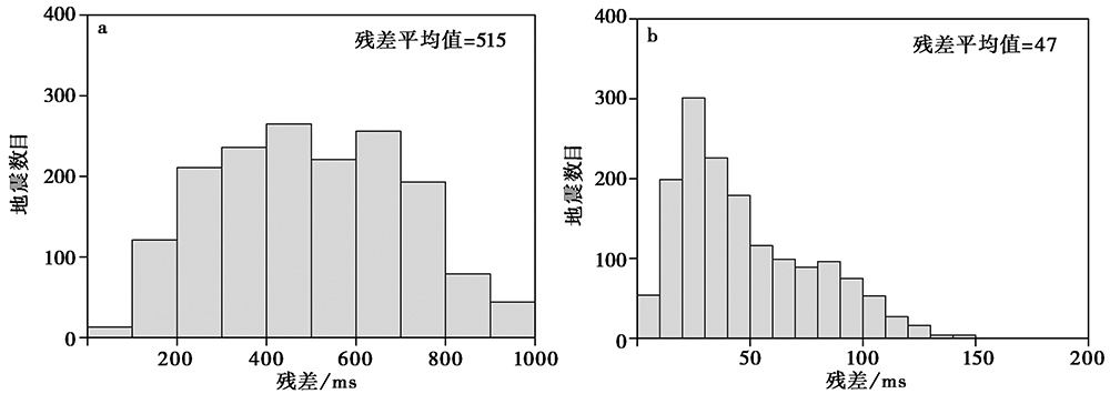
图 4 定位前(a)、 后(b)0~1 200ms范围内地震走时残差均方根直方图
Fig. 4 Histograms of travel time residual RMS between 0~1 200ms for seismic events before(a)and after(b)the relocation.
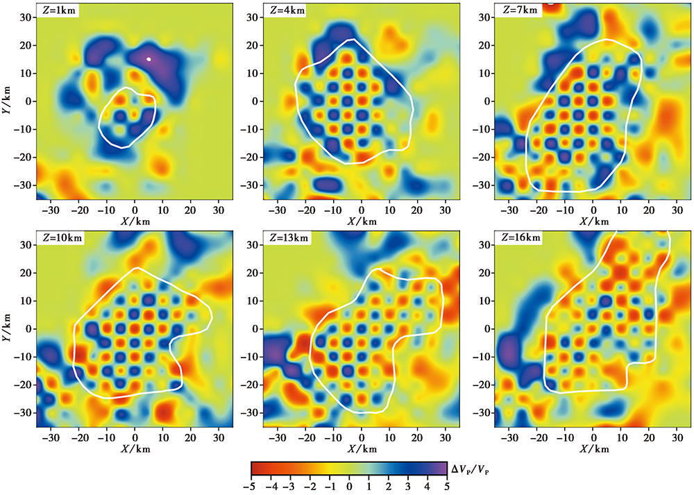
图 5 研究区内不同深度的检测板结果
Fig. 5 Checkerboard test results at different depths in the study area.
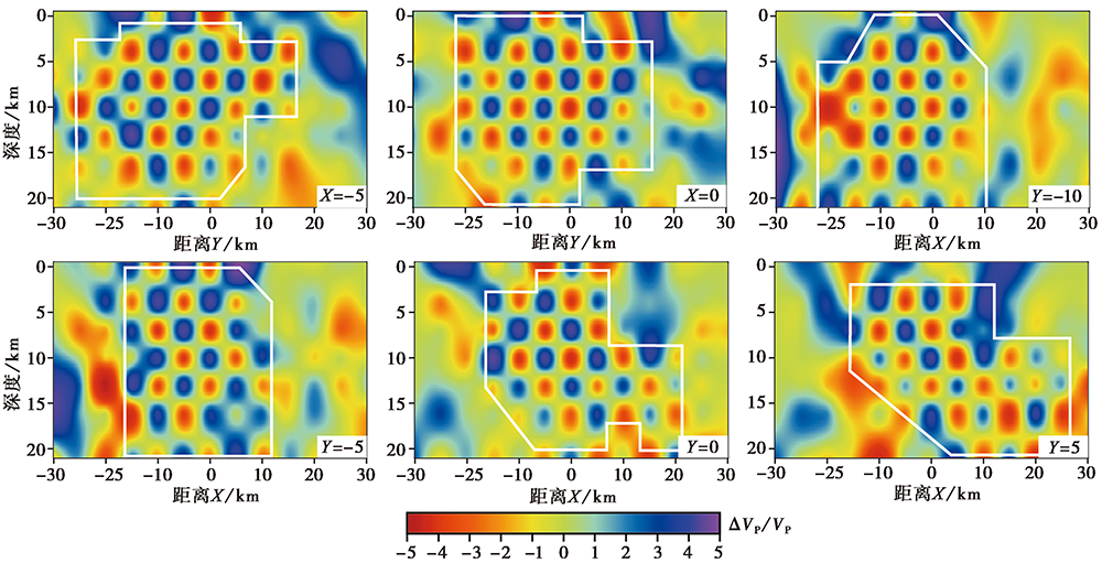
图 6 沿X、 Y方向速度剖面的检测板结果
Fig. 6 Checkerboard test results along the direction of X and Y.
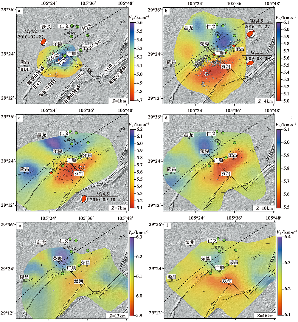
图 7 深度为0~16km处的P波速度结构及地震分布 红色五角星表示层面上下各1.5km范围MS>4.0的地震(图8相同)
Fig. 7 Distribution of P wave velocity structure and earthquake in 0~16km deep layer.
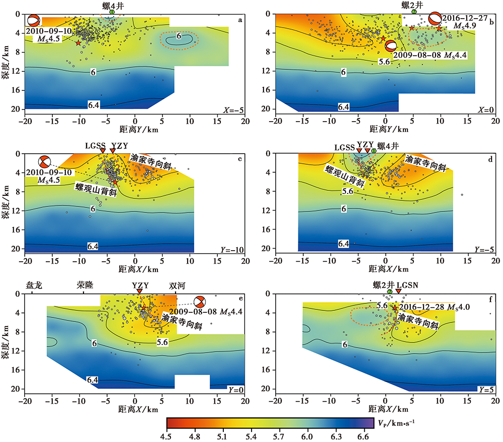
图 8 研究区不同剖面的P波速度结构 红色倒三角表示断层在地表的位置
Fig. 8 P wave velocity structure along the different profiles.
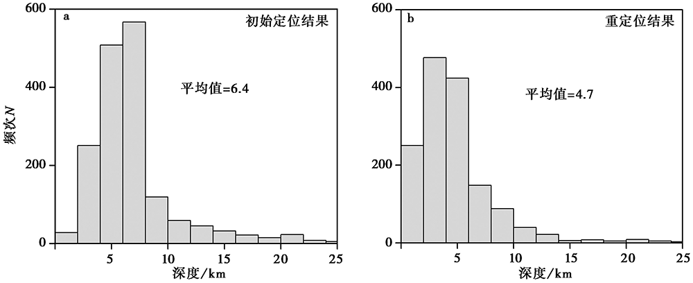
图 9 初始定位(a)和重定位(b)震源深度统计直方图
Fig. 9 The statistical histogram of focal depth before(a) and after(b) relocation.
| 序号 | 发震时间 | 震级 /MS | 节面Ⅰ/(°) | 节面Ⅱ/(°) | P轴/(°) | T轴/(°) | ||||||
|---|---|---|---|---|---|---|---|---|---|---|---|---|
| 走向 | 倾角 | 滑动角 | 走向 | 倾角 | 滑动角 | 方位角 | 仰角 | 方位角 | 仰角 | |||
| ① | 2009-08-08 | 4.3 | 246 | 42 | 86 | 71 | 48 | 94 | 159 | 3 | 20 | 86 |
| ② | 2010-02-22 | 4.2 | 205 | 38 | 80 | 41 | 53 | 103 | 122 | 7 | 342 | 80 |
| ③ | 2010-09-10 | 4.5 | 193 | 45 | 82 | 24 | 46 | 98 | 109 | 0 | 16 | 84 |
| ④ | 2016-12-27 | 4.9 | 259 | 46 | 127 | 32 | 55 | 58 | 144 | 5 | 244 | 64 |
表2 研究区MS≥4.0地震的震源机制解
Table 2 Focal mechanism solutions of MS≥4.0 earthquake in the study area
| 序号 | 发震时间 | 震级 /MS | 节面Ⅰ/(°) | 节面Ⅱ/(°) | P轴/(°) | T轴/(°) | ||||||
|---|---|---|---|---|---|---|---|---|---|---|---|---|
| 走向 | 倾角 | 滑动角 | 走向 | 倾角 | 滑动角 | 方位角 | 仰角 | 方位角 | 仰角 | |||
| ① | 2009-08-08 | 4.3 | 246 | 42 | 86 | 71 | 48 | 94 | 159 | 3 | 20 | 86 |
| ② | 2010-02-22 | 4.2 | 205 | 38 | 80 | 41 | 53 | 103 | 122 | 7 | 342 | 80 |
| ③ | 2010-09-10 | 4.5 | 193 | 45 | 82 | 24 | 46 | 98 | 109 | 0 | 16 | 84 |
| ④ | 2016-12-27 | 4.9 | 259 | 46 | 127 | 32 | 55 | 58 | 144 | 5 | 244 | 64 |
| [1] | 丁仁杰, 李克昌. 2004. 重庆地震研究[M]. 北京: 地震出版社. |
| DING Ren-jie, LI Ke-chang. 2004. Research of Earthquakes in Chongqing[M]. Seismological Press, Beijing. (in Chinese) | |
| [2] |
韩晓明, 刘芳, 张帆, 等. 2018. 鄂尔多斯块体东北缘的P波速度精细结构[J]. 地震地质, 40(1): 215-231. doi: 10.3969/j.issn.0253-4967.2018.01.016.
DOI |
| HAN Xiao-ming, LIU Fang, ZHANG Fan, et al. 2018. 3D P-wave velocity structure at the northeastern margin of Ordos block[J]. Seismology and Geology, 40(1): 215-231. (in Chinese) | |
| [3] | 黄世源, 魏红梅, 朱丽霞. 2007. 2006年荣昌地震活动与注水关系[J]. 高原地震, 19(2): 8-11. |
| HUANG Shi-yuan, WEI Hong-mei, ZHU Li-xia. 2007. Relationship between the Rongchang earthquake 2006 and water injection[J]. Plateau Earthquake Research, 19(2): 8-11. (in Chinese) | |
| [4] |
李峰, 张效亮, 刘华国. 2013. 重庆市主要构造地震危险性评价[J]. 地震地质, 35(3): 518-531. doi: 10.3969/j.issn.0253-4967.2013.03.006.
DOI |
| LI Feng, ZHANG Xiao-liang, LIU Hua-guo. 2013. Seismic hazard analysis of the main faults in Chongqing urban area[J]. Seismology and Geology, 35(3): 518-531. (in Chinese) | |
| [5] |
刘白云, 王小娜, 尹志文, 等. 2018. 1927年古浪8级大震及其周边地区三维地壳P波速度结构特征[J]. 地球物理学报, 61(10): 3980-3993. doi: 10.6038/cjg2018K0582.
DOI |
| LIU Bai-yun, WANG Xiao-na, YIN Zhi-wen, et al. 2018. 3D P-wave crustal velocity structure of the 1927 Gulang M8 earthquake and its adjacent area[J]. Chinese Journal of Geophysics, 61(10): 3980-3993. (in Chinese) | |
| [6] | 史謌, 沈文略, 杨东全. 2003. 岩石弹性波速度和饱和度、 孔隙流体分布的关系[J]. 地球物理学报, 46(1): 138-142. |
| SHI Ge, SHEN Wen-lue, YANG Dong-quan. 2003. The relationship of wave velocity with saturation and fluid distribution in pore space[J]. Chinese Journal of Geophysics, 46(1): 138-142. (in Chinese) | |
| [7] | 万永革, 沈正康, 刁桂苓, 等. 2008. 利用小震分布和区域应力场确定大震断层面参数方法及其在唐山地震序列中的应用[J]. 地球物理学报, 51(3): 793-804. |
| WAN Yong-ge, SHEN Zheng-kang, DIAO Gui-ling, et al. 2008. An algorithm of fault parameter determination using distribution of small earthquakes and parameters of regional stress field and its application to Tangshan earthquake sequence[J]. Chinese Journal of Geophysics, 51(3): 793-804. (in Chinese) | |
| [8] |
王长在, 吴建平, 杨婷, 等. 2018. 太原盆地及周边地区双差层析成像[J]. 地球物理学报, 61(3): 963-974. doi: 10.6038/cjg2018L0114.
DOI |
| WANG Chang-zai, WU Jian-ping, YANG Ting, et al. 2018. Crustal structure beneath the Taiyuan Basin and adjacent areas revealed by double-difference tomography[J]. Chinese Journal of Geophysics, 61(3): 963-974. (in Chinese) | |
| [9] |
王小龙, 雷兴林, 勾宪斌, 等. 2015. 用CAP方法研究重庆荣昌2014年2月23日ML3.8地震震源机制[J]. 中国地震, 31(2): 290-296. doi: 10.3969/j.issn.1001-4683.2015.02.013.
DOI |
| WANG Xiao-long, LEI Xing-lin, GOU Xian-bin, et al. 2015. Focal mechanism solution of the February 23, 2014, ML3.8 Rongchang earthquake with the CAP(Cut and Paste)method[J]. Earthquake Research in China, 31(2): 290-296. (in Chinese) | |
| [10] |
王小龙, 马胜利, 雷兴林, 等. 2012. 重庆荣昌诱发地震区精细速度结构及2010年ML5.1地震序列精确定位[J]. 地震地质, 34(2): 348-358. doi: 10.3969/j.issn.0253-4967.2012.02.013.
DOI |
| WANG Xiao-long, MA Sheng-li, LEI Xing-lin, et al. 2012. Fine velocity structure and relocation of the 2010 ML5.1 earthquake sequence in Rongchang gas filed[J]. Seismology and Geology, 34(2): 348-358. (in Chinese) | |
| [11] |
王小娜, 于湘伟, 章文波. 2015. 芦山震区地壳三维P波速度精细结构及地震重定位研究[J]. 地球物理学报, 58(4): 1179-1193. doi: 10.6038/cjg20150408.
DOI |
| WANG Xiao-na, YU Xiang-wei, ZHANG Wen-bo. 2015. 3D P-wave velocity structure of the crust and relocation of earthquakes in the Lushan source area[J]. Chinese Journal of Geophysics, 58(4): 1179-1193. (in Chinese) | |
| [12] |
王赞军, 王宏超, 董娣, 等. 2018. 华蓥山断裂带的物探成果综述[J]. 四川地震, (3): 6-12. doi: 10.137716/j.cnki.1001-8115.2018.03.002.
DOI |
| WANG Zan-jun, WANG Hong-chao, DONG Di, et al. 2018. Review of geophysical results of Huayingshan fault zone[J]. Earthquake Research in Sichuan, (3): 6-12. (in Chinese) | |
| [13] |
王志伟, 王小龙, 马胜利, 等. 2018. 重庆荣昌地区注水诱发地震的时空分布特征[J]. 地震地质, 40(3): 523-538. doi: 10.3969/j.issn.0253-4967.2018.03.002.
DOI |
| WANG Zhi-wei, WANG Xiao-long, MA Sheng-li, et al. 2018. Detailed temporal-spatial distribution of induced earthquakes by water injection in Rongchang, Congqing[J]. Seismology and Geology, 40(3): 523-538. (in Chinese) | |
| [14] |
魏红梅, 刘国彪. 2014. 重庆荣昌地震活动特征与深井注水关系探讨[J]. 地震地磁观测与研究, 35(3-4): 187-191. doi: 10.3969/j.issn.1003-3246.2014.03/04.031.
DOI |
| WEI Hong-mei, LIU Guo-biao. 2014. Study of relationship between characteristics of seismic activity and deep-well injection at Rongchong County of Chongqing Municipality[J]. Seismological and Geomagnetic Observation and Research, 35(3-4): 187-191. (in Chinese) | |
| [15] |
吴海波, 申学林, 王杰, 等. 2018. 三峡库区上地壳三维速度结构的双差层析成像研究[J]. 地球物理学报, 61(7): 2802-2814. doi: 10.6038/cjg2018L0345.
DOI |
| WU Hai-bo, SHEN Xue-lin, WANG Jie, et al. 2018. Three-dimensional velocity structure of upper crust in the Three Gorges Reservoir area derived from double-difference tomography[J]. Chinese Journal of Geophysics, 61(7): 2802-2814. (in Chinese) | |
| [16] |
肖卓, 高原. 2017. 利用双差成像方法反演青藏高原东北缘及其邻区地壳速度结构[J]. 地球物理学报, 60(6): 2213-2225. doi: 10.6038/cjg20170615.
DOI |
| XIAO Zhuo, GAO Yuan. 2017. Crustal velocity structure beneath the northeastern Tibetan plateau and adjacent regions derived from double difference tomography[J]. Chinese Journal of Geophysics, 60(6): 2213-2225. (in Chinese) | |
| [17] | 张致伟, 程万正, 吴朋, 等. 2013. 自贡-隆昌地区地震重新定位及P波速度结构研究[J]. 中国地震, 29(1): 37-47. |
| ZHANG Zhi-wei, CHENG Wan-zheng, WU Peng, et al. 2013. Study on earthquake relocation and P-wave velocity structure in the Zigong and Longchang area[J]. Earthquake Research in China, 29(1): 37-47. (in Chinese) | |
| [18] |
张致伟, 龙锋, 王世元, 等. 2019. 四川宜宾地区地震定位及速度结构[J]. 地震地质, 41(4): 913-926. doi: 10.3969/j.issn.0253-4967.2019.04.007.
DOI |
| ZHANG Zhi-wei, LONG Feng, WANG Shi-yuan, et al. 2019. Earthquake location and velocity structure in Yibin area, Sichuan[J]. Seismology and Geology, 41(4): 913-926. (in Chinese) | |
| [19] | 赵从俊. 1984. 四川盆地构造垂向变异特征类型及其机理探讨[J]. 石油学报, 5(2): 11-21. |
| ZHANG Cong-jun. 1984. On the characteristics, type and mechanism of vertical structural variations in Sichuan Basin[J]. Acta Petrolei Sinica, 5(2): 11-21. (in Chinese) | |
| [20] | 朱丽霞, 黄世源, 魏红梅. 2007. 荣昌地区注水地震研究[J]. 大地测量与地球动力学, 27(6): 86-90. |
| ZHU Li-xia, HUANG Shi-yuan, WEI Hong-mei. 2007. On fluid-injection induced earthquake in Rongchang area[J]. Journal of Geodesy and Geodynamics, 27(6): 86-90. (in Chinese) | |
| [21] |
Dixit M M, Kumar S, Catchings R D, et al. 2015. Seismicity, faulting, and structure of the Koyna-Warna seismic region, western India from local earthquake tomography and hypocenter locations[J]. Journal of Geophysical Research Solid Earth, 119(8): 6372-6398.
DOI URL |
| [22] |
Domenico S N. 1974. Effect of water saturation on seismic reflectivity of sand reservoirs encased in Shale[J]. Geophysics, 39(6): 759-769.
DOI URL |
| [23] | Eberhart P D. 1986. Three-dimensional velocity structure in northern California Coast Ranges from inversion of local earthquake arrival times[J]. Bulletin of the Seismological Society of Americal, 76(4): 1025-1052. |
| [24] |
Lei X L, Yu G Z, Ma S L, et al. 2008. Earthquakes induced by water injection at-3km depth within the Rongchang gas field, Chongqing, China[J]. Journal of Geophysical Research, 113(B10): B10310.
DOI URL |
| [25] |
Long F, Zhang Z W, Qi Y P, et al. 2020. Three dimensional velocity structure and accurate earthquake location in Changning-Gongxian area of southeast Sichuan[J]. Earth and Planetary Physics, 4( 2): 163-177. doi.org/10.26464/epp2020022.
DOI URL |
| [26] |
Waldhauser F, Ellsworth W L. 2000. A double-difference earthquake location algorithm: Method and application to the northern Hayward Fault, California[J]. Bulletin of the Seismological Society of America, 90(6): 1353-1368.
DOI URL |
| [27] |
Zhang H J, Thurber C H. 2003. Double-difference tomography: The method and its application to the Hayward Fault, California[J]. Bulletin of the Seismological Society of America, 93(5): 1875-1889.
DOI URL |
| [28] |
Zhang H L, Thurber C H. 2006. Development and applications of double-difference seismic tomography[J]. Pure and Applied Geophysics, 163(2-3): 373-403.
DOI URL |
| [29] | Zhao D P, Hasegawa A, Horiuchi S. 1992. Tomographic imaging of P and S wave velocity structure beneath northeastern Japan[J]. Journal of Geophysical Research: Solid Earth, 97(B13): 19909-19928. |
| [1] | 宋刚, 杨晓松. 甘肃省老虎山断裂带区域地壳纵波速度的实验[J]. 地震地质, 2022, 44(5): 1273-1289. |
| [2] | 李宗旭, 贺日政, 冀战波, 李娱兰, 牛潇. 2009年7月24日西藏尼玛MS5.6地震的震源机制及其构造意义[J]. 地震地质, 2022, 44(4): 992-1010. |
| [3] | 曹颖, 钱佳威, 黄江培, 张国权, 付虹. 利用时移层析成像方法分析2014年云南景谷MS6.6地震震源区的P波速度变化[J]. 地震地质, 2021, 43(6): 1563-1585. |
| [4] | 尹欣欣, 蒋长胜, 蔡润, 郭祥云, 姜丛, 王祖东, 邹小波. 云南漾濞地区地壳层析成像与地震精定位[J]. 地震地质, 2021, 43(4): 864-880. |
| [5] | 罗仁昱, 陈继锋, 尹欣欣, 李少华. 青海共和及周边地区的地壳三维速度结构[J]. 地震地质, 2021, 43(1): 232-248. |
| [6] | 赵博, 高原, 刘杰, 梁姗姗. 四川长宁MS6.0地震震源干涉成像定位[J]. 地震地质, 2020, 42(6): 1474-1491. |
| [7] | 李霞, 陈时军, 张正帅, 戴宗辉, 李小晗, 卢仲斌. 山东庙岛群岛地区P波三维速度结构反演与2017年震群的发震构造分析[J]. 地震地质, 2020, 42(5): 1188-1204. |
| [8] | 梁姗姗, 徐志国, 盛书中, 张广伟, 赵博, 邹立晔. 2019年四川长宁6.0级地震主震及中强余震(MS≥4.0)的震源机制及其应力场[J]. 地震地质, 2020, 42(3): 547-561. |
| [9] | 张娜, 赵翠萍, 李春宏, 周连庆. 基于加密观测的金沙江下游水库区速度结构成像[J]. 地震地质, 2019, 41(6): 1380-1394. |
| [10] | 张致伟, 龙锋, 王世元, 宫悦, 吴朋, 王辉, 江国茂. 四川宜宾地区地震定位及速度结构[J]. 地震地质, 2019, 41(4): 913-926. |
| [11] | 曲均浩, 王长在, 刘方斌, 周少辉, 郑建常, 李新凤, 张芹. 乳山序列地震分布与震源区速度结构的关系[J]. 地震地质, 2019, 41(1): 99-118. |
| [12] | 徐志国, 梁姗姗, 邹立晔, 刘敬光. 2016年12月8日新疆呼图壁MS6.2主震震源机制及余震序列定位[J]. 地震地质, 2019, 41(1): 44-57. |
| [13] | 王志伟, 王小龙, 马胜利, 雷兴林, 刘培洵. 重庆荣昌地区注水诱发地震的时空分布特征[J]. 地震地质, 2018, 40(3): 523-538. |
| [14] | 韩晓明, 刘芳, 张帆, 陈立峰, 李娟, 李拴虎, 杨红樱. 鄂尔多斯块体东北缘的P波速度精细结构[J]. 地震地质, 2018, 40(1): 215-231. |
| [15] | 杨婷, 吴建平, 房立华, 王未来. 2014年云南盈江MS5.6和MS6.1地震余震序列重定位[J]. 地震地质, 2016, 38(4): 1047-1057. |
| 阅读次数 | ||||||
|
全文 |
|
|||||
|
摘要 |
|
|||||
