地震地质 ›› 2022, Vol. 44 ›› Issue (2): 378-394.DOI: 10.3969/j.issn.0253-4967.2022.02.007
王亮( ), 焦明若*(), 钱蕊, 张博, 杨士超, 邵媛媛
收稿日期:2021-01-27
修回日期:2021-06-01
出版日期:2022-04-20
发布日期:2022-06-14
通讯作者:
焦明若
作者简介:王亮, 男, 1983年生, 2012年于中国科学技术大学获固体地球物理专业硕士学位, 高级工程师, 主要从事地震定位与地震成像研究, 电话: 18304007037, E-mail: xie_god@163.com。
基金资助:
WANG Liang(), JIAO Ming-ruo*(), QIAN Rui, ZHANG Bo, YANG Shi-chao, SHAO Yuan-yuan
Received:2021-01-27
Revised:2021-06-01
Online:2022-04-20
Published:2022-06-14
Contact:
JIAO Ming-ruo
摘要:
文中利用辽宁地区“十五”改造前后共67个区域地震台记录的1975年8月—2017年12月期间的地震震相观测报告, 通过双差地震成像的方法, 采用tomoDD软件对辽南地区进行了地震重新定位及速度结构反演。通过计算得到了辽南地区记录大部分地震的重新定位结果和4km、 13km、 24km、 33km几个深度上较好的P波速度结果。重新定位结果显示, 海城余震区和盖州震群活动区域作为辽南地区主要的地震活动区域, 其地震活动具有明显的NW向展布特征。P波层析成像结果则反映了辽南地区浅部速度结构与地质构造较为一致的特点。海城余震区所处的海城河断裂在浅层存在高速体, 在4~12km深度存在低速体, 且低速体向E不断加深侵入。金州断裂不同分段的端部存在高速体, 其断裂端部的盖州震群发生在高速体区域, 推测盖州震群的活动可能是在应力积累的条件下受到液体侵入而使岩石的含水饱和率上升所致。
中图分类号:
王亮, 焦明若, 钱蕊, 张博, 杨士超, 邵媛媛. 利用双差地震成像方法反演辽南地区地壳速度结构[J]. 地震地质, 2022, 44(2): 378-394.
WANG Liang, JIAO Ming-ruo, QIAN Rui, ZHANG Bo, YANG Shi-chao, SHAO Yuan-yuan. CRUSTAL VELOCITY STRUCTURE BENEATH THE SOUTHERN LIAONING PROVINCE DERIVED FROM DOUBLE DIFFERENCE TOMOGRAPHY[J]. SEISMOLOGY AND GEOLOGY, 2022, 44(2): 378-394.
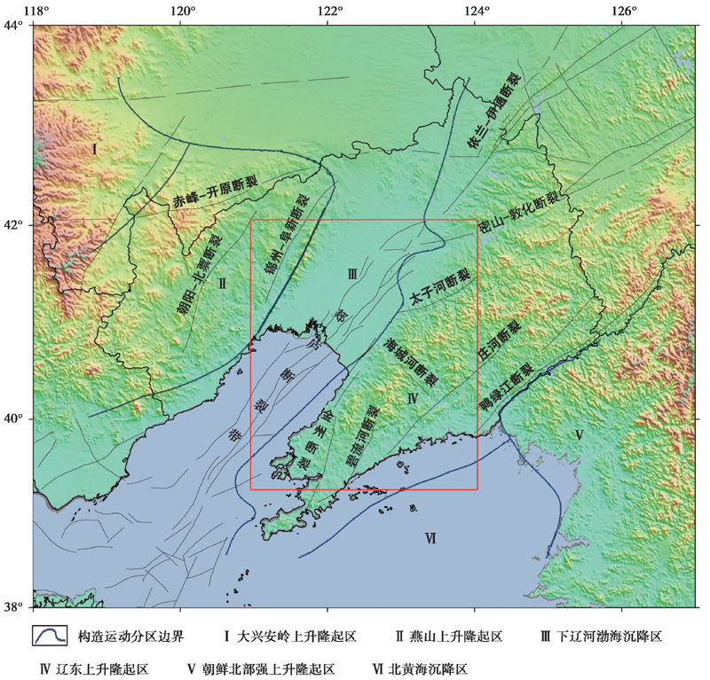
图 1 辽宁地区活动断裂及地质单元分区图(据万波等, 2017重新绘制) 红色方框为研究区域
Fig. 1 Distribution of active faults and geological units in Liaoning area(adapted from WAN Bo et al., 2017).
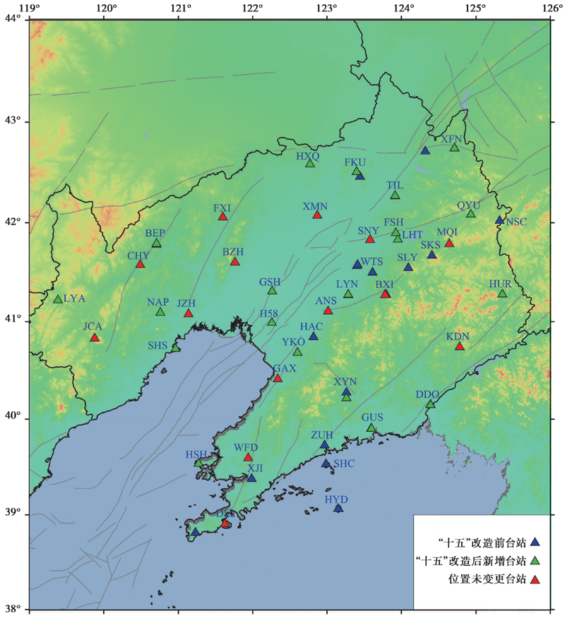
图 2 辽宁地区的台站分布情况
Fig. 2 The distribution of seismic stations in Liaoning area.
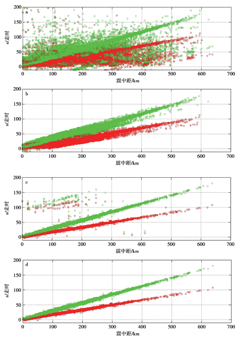
图 3 辽宁地区1975—2017年震相数据校正前、 后的对比 a “十五”改造前校正前; b “十五”改造前校正后; c “十五”改造后校正前; d “十五”改造后校正后。 红色为P波震相, 绿色为S波震相
Fig. 3 Fitting curve of travel time and epicenter distance.
| 上界面深度/km | -1.5 | 0 | 4 | 13 | 24 | 33 | 35 | 77 |
|---|---|---|---|---|---|---|---|---|
| P波速度/km·s-1 | 4.2 | 4.5 | 5.8 | 6.1 | 6.4 | 6.8 | 7.8 | 8.0 |
表1 一维速度模型
Table1 The one dimensional P wave velocity model
| 上界面深度/km | -1.5 | 0 | 4 | 13 | 24 | 33 | 35 | 77 |
|---|---|---|---|---|---|---|---|---|
| P波速度/km·s-1 | 4.2 | 4.5 | 5.8 | 6.1 | 6.4 | 6.8 | 7.8 | 8.0 |
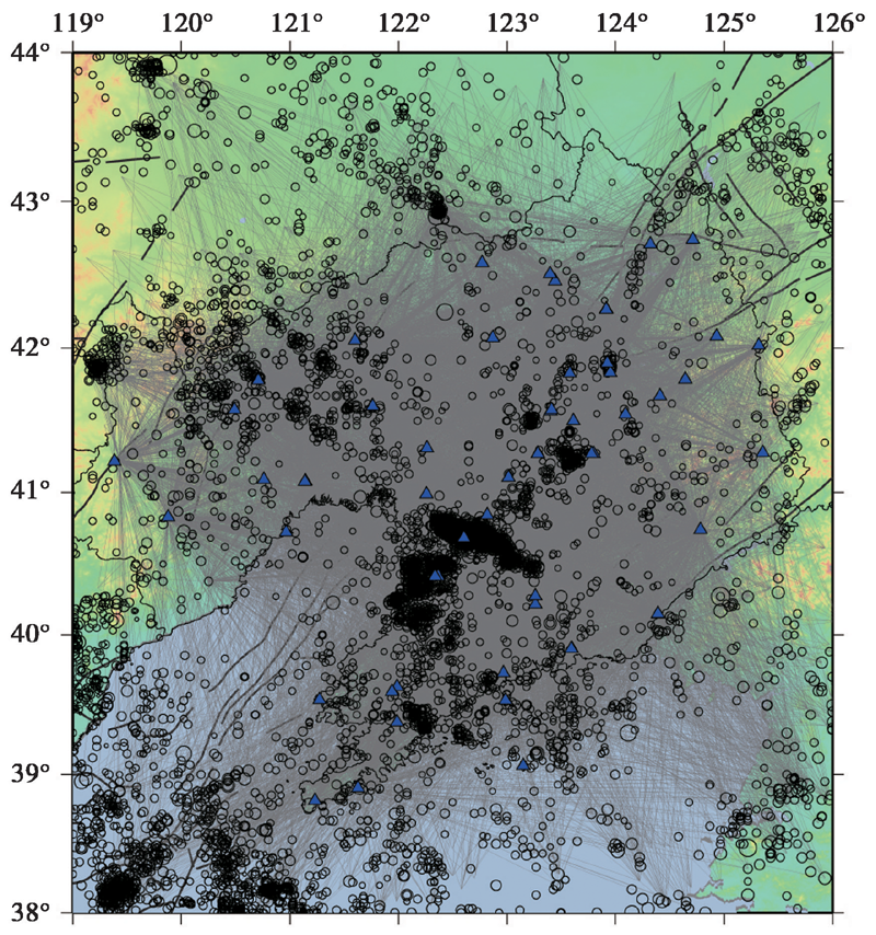
图 4 参与反演的射线分布情况 空心圆为震中, 蓝色三角形为台站
Fig. 4 Ray distribution involved in inversion.

图 5 网格划分 a 计算区域; b 研究区域。空心圆为震中, 蓝色三角形为台站
Fig. 5 Division of grid cells.
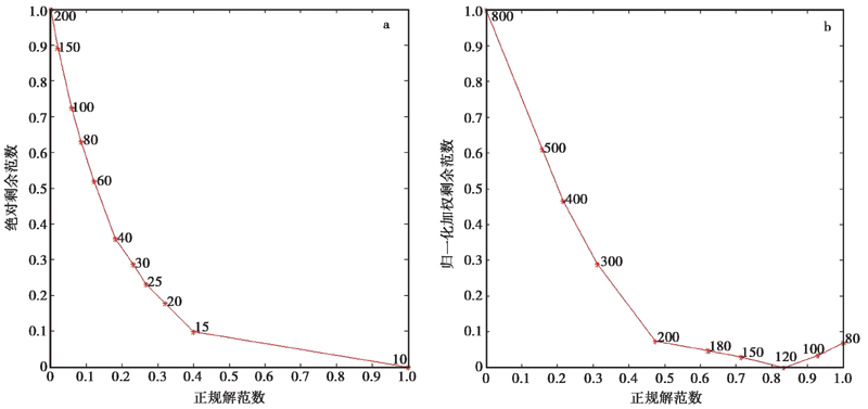
图 6 光滑因子(a)和阻尼参数(b)的均衡归一化曲线
Fig. 6 The best smoothing factor(a)and damping parameter(b)selected using L-curve method.
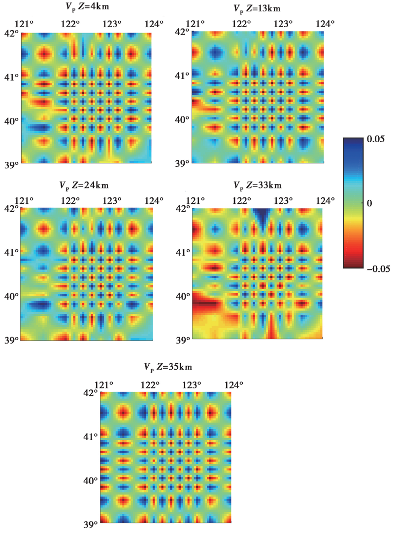
图 7 不同深度的棋盘格检测板测试结果
Fig. 7 Results of checkerboard test at different depths.
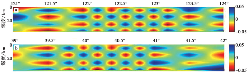
图 8 不同剖面的棋盘格检测板测试结果
Fig. 8 Results of checkerboard test in different profiles.
图 9 研究区定位前、 后的深度分布图 a 重定位后; b 重定位前
Fig. 9 Depth distribution before and after relocation in the study area.
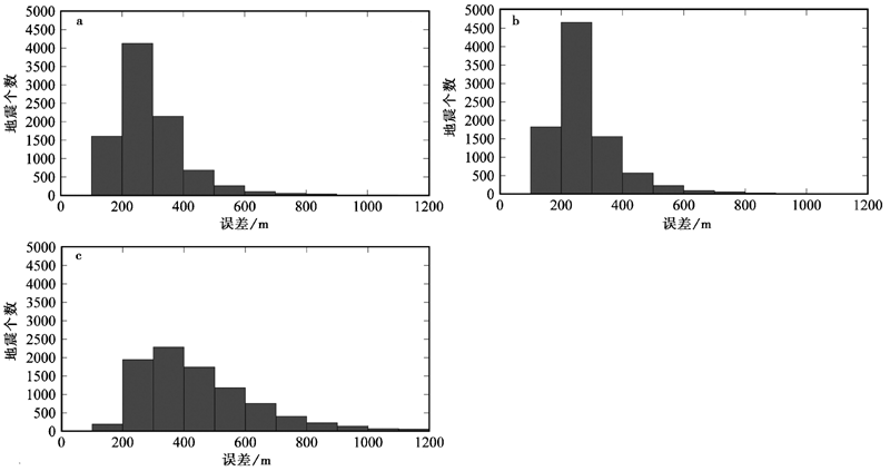
图 10 研究区重定位后各方向的误差 a 纬度方向; b 经度方向; c 深度方向
Fig. 10 The error in each direction after relocation in the study area.
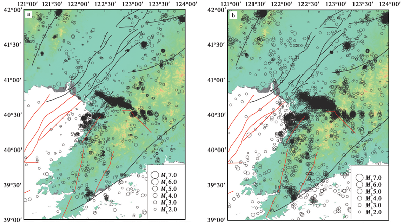
图 11 研究区重定位前、 后的震中分布 a 重定位后; b 重定位前
Fig. 11 Epicenter distribution before and after relocation in the study area.
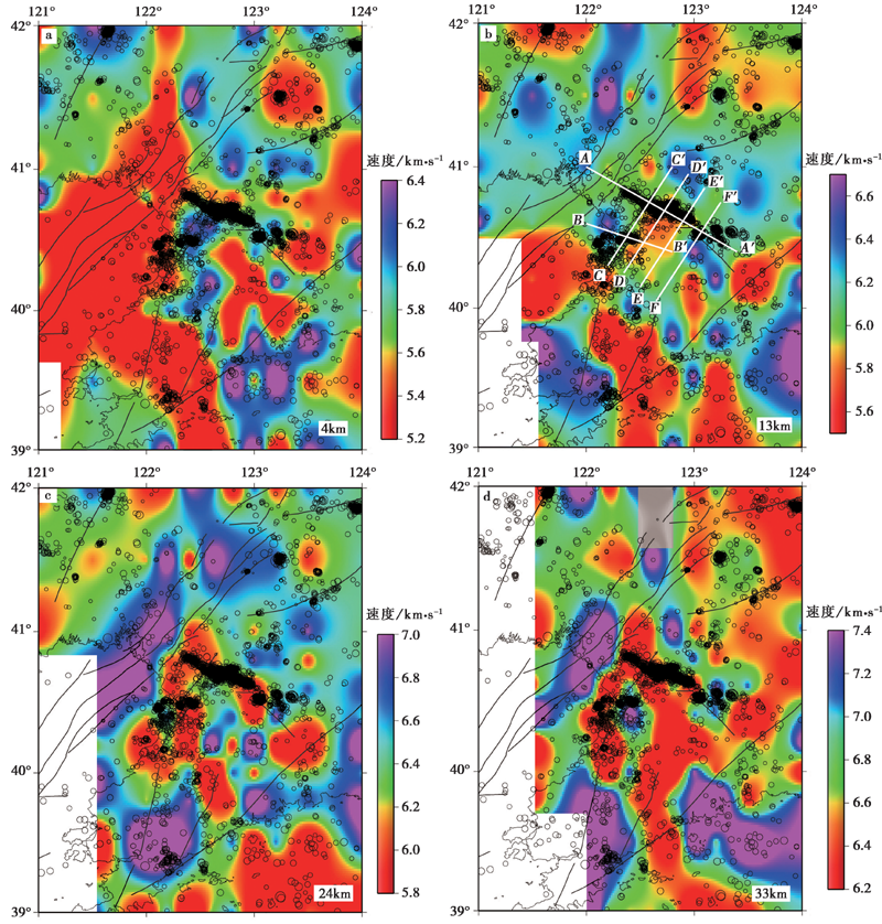
图 12 辽南地区不同深度的P波速度反演结果 图中白色部分为分辨率较差的区域
Fig. 12 Inversion results of P-wave velocity at different depths in southern Liaoning Province.
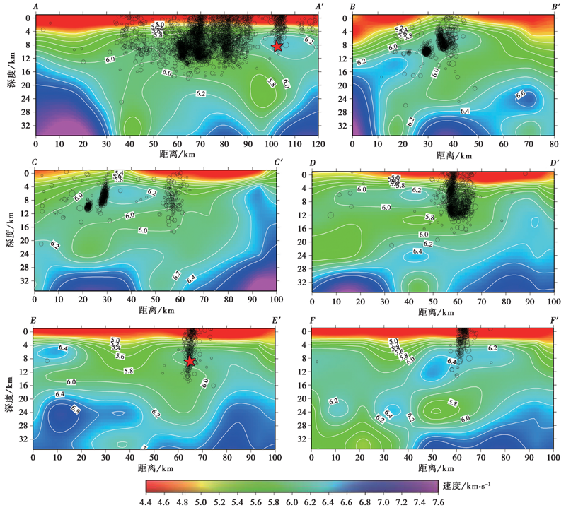
图 13 不同剖面的P波速度模型 图中红星为岫岩5.4级地震的震中位置
Fig. 13 P-wave velocity model for different profiles.
| [1] | 蔡国刚. 2010. 辽河裂谷东部凹陷粗面岩成因机理探讨[J]. 地球学报, 31(2): 245-250. |
| CAI Guo-gang. 2010. Genetic mechanism of trachyte in the eastern depression of Liaohe rift[J]. Acta Geoscientica Sinica, 31(2): 245-250. (in Chinese) | |
| [2] | 高常波, 钟以章. 2000. 1999年辽宁海城-岫岩5.6级地震的地质构造背景和发震构造[J]. 地震地质, 22(4): 405-412. |
| GAO Chang-bo, ZHONG Yi-zhang. 2000. Geological background and seismogenic fault of the Haicheng-Xiuyan M5.6 earthquake of November 29, 1999[J]. Seismology and Geology, 22(4): 405-412. (in Chinese) | |
| [3] | 李荣安, 徐平, 焦明若, 等. 1997. 海城地震地区地壳三维结构特征[J]. 地震地质, 19(1): 9-13. |
| LI Rong-an, XU Ping, JIAO Ming-ruo,et al. 1997. Features of the three dimensional crustal structure of the Haicheng seismic area[J]. Seismology and Geology, 19(1): 9-13. (in Chinese) | |
| [4] | 卢造勋, 蒋秀琴, 潘科, 等. 2002. 中朝地台东北缘地区的地震层析成像[J]. 地球物理学报, 45(3): 338-351. |
| LU Zao-xun, JIANG Xiu-qin, PAN Ke,et al. 2002. Seismic tomography in the northeast margin area of Sino-Korean Platform[J]. Chinese Journal of Geophysics, 45(3): 338-351. (in Chinese) | |
| [5] | 卢造勋, 孟补在, 赵俊猛. 1989. 闾阳-海城-东沟剖面地壳与上地幔速度结构特征与地震[J]. 东北地震研究, 5(4): 1-11. |
| LU Zao-xun, MENG Bu-zai, ZHAO Jun-meng. 1989. Velocity structure characteristics of the crust and upper mantle in Luyang-Haicheng-Donggou DSS profile and the earthquake[J]. Seismological Research of Northeast China, 5(4): 1-11. (in Chinese) | |
| [6] | 史謌, 沈文略, 杨东全. 2003. 岩石弹性波速度和饱和度、 孔隙流体分布的关系[J]. 地球物理学报, 46(1): 138-142. |
| SHI Ge, SHEN Wen-lue, YANG Dong-quan, 2003. The relationship of wave velocities with saturation and fluid distribution in pore space[J]. Chinese Journal of Geophysics, 46(1): 138-142. (in Chinese) | |
| [7] | 万波, 贾丽华, 戴盈磊, 等. 2013. 辽东半岛中强地震活动及其与构造相关性[J]. 地震地质, 35(2): 300-314. |
| WAN Bo, JIA Li-hua, DAI Ying-lei,et al. 2013. Moderate-strong earthquakes and their tectonic correlation in the Liaodong peninsula[J]. Seismology and Geology, 35(2): 300-314. (in Chinese) | |
| [8] | 万波, 靳超宇, 索瑞. 2017. 辽宁省及邻近地区主要地震构造及其危险性判定[J]. 防灾减灾学报, 33(1): 1-11. |
| WAN Bo, JIN Chao-yu, SUO Rui. 2017. Judgment for the main seismic structures and their seismic risk classifications in Liaoning Province and its adjacent area[J]. Journal of Disaster Prevention and Reduction, 33(1): 1-11. (in Chinese) | |
| [9] | 王长在, 吴建平, 房立华, 等. 2013. 玉树地震震源区速度结构与余震分布的关系[J]. 地球物理学报, 56(12): 4072-4083. |
| WANG Chang-zai, WU Jian-ping, FANG Li-hua,et al. 2013. The relationship between wave velocity structure around Yushu earthquake source region and the distribution of aftershocks[J]. Chinese Journal of Geophysics, 56(12): 4072-4083. (in Chinese) | |
| [10] | 王亮, 周龙泉, 焦明若, 等. 2014. 海城盖州地区速度结构和震源位置的联合反演研究[J]. 地震, 34(3): 13-26. |
| WANG Liang, ZHOU Long-quan, JIAO Ming-ruo,et al. 2014. Simultaneous inversion for earthquake hypocenters and velocity structure in Haicheng and Gaizhou area[J]. Earthquake, 34(3): 13-26. (in Chinese) | |
| [11] | 王伟平. 2016. 鲜水河、 安宁河和龙门山断裂带交会区双差层析成像研究[D]. 北京: 中国地震局地球物理研究所. |
| WANG Wei-ping. 2016. The application of double difference tomography method in the intersection zone of Xianshuihe Fault, Anninghe Fault and Longmenshan Fault[D]. Institute of Geophysics, China Earthquake Administration, Beijing. (in Chinese) | |
| [12] | 王小娜, 于湘伟, 章文波. 2015. 芦山震区地壳三维P波速度精细结构及地震重定位研究[J]. 地球物理学报, 58(4): 1179-1193. |
| WANG Xiao-na, YU Xiang-wei, ZHANG Wen-bo. 2015. 3D P-wave velocity structure of the crust and relocation of earthquakes in the Lushan source area[J]. Chinese Journal of Geophysics, 58(4): 1179-1193. (in Chinese) | |
| [13] | 张博, 钱蕊. 2019. 盖州青石岭震群的震源参数特征[J]. 中国地震, 35(2): 269-276. |
| ZHANG Bo, QIAN Rui. 2019. A study on characteristics of source parameters of the Gaizhou Qingshiling earthquake swarm[J]. Earthquake Research in China, 35(2): 269-276. (in Chinese) | |
| [14] | 赵俊猛, 卢造勋. 1998. 辽河裂谷的深部构造与裂谷活动的侧向迁移[J]. 地震地质, 20(3): 225-233. |
| ZHAO Jun-meng, LU Zao-xun. 1998. Deep structure of Liaohe rift and eastward migration of rift activity[J]. Seismology and Geology, 20(3): 225-233. (in Chinese) | |
| [15] |
Haslinger F, Kissling E. 2001. Investigating effects of 3-D ray tracing methods in local earthquake tomography[J]. Physics of the Earth and Planetary Interiors, 123(2-4): 103-114.
DOI URL |
| [16] |
Spakman W, Lee S, Hilst R. 1993. Travel-time tomography of the European-Mediterranean mantle down to 1400km[J]. Physics of the Earth and Planetary Interiors, 79(1-2): 3-74.
DOI URL |
| [17] | Thurber C H. 1983. Earthquake locations and three-dimensional crustal structure in the Coyote Lake area, central California[J]. Journal of Geophysical Research: Solid Earth, 88(B10): 8226-8236. |
| [18] |
Zhang H, Thurber C H. 2006. Development and applications of double-difference seismic tomography[J]. Pure and Applied Geophysics, 163(2-3): 373-403.
DOI URL |
| [19] |
Zheng Q, Liu C, Tian Y,et al. 2018. Seismic imaging of the middle and upper crust by double-difference tomography: The Haicheng earthquake( MS7.3 )in Liaoning Province[J]. Applied Geophysics, 15(1): 125-136.
DOI URL |
| [1] | 宫猛, 吕坚, 郑勇, 谢祖军, 盛书中, 张杏棉. 华南地块及邻区基于背景噪声的壳幔三维S波速度结构[J]. 地震地质, 2022, 44(4): 1011-1028. |
| [2] | 李翠平, 唐茂云, 郭卫英, 王小龙, 董蕾. 荣昌及周边三维速度结构初步研究[J]. 地震地质, 2022, 44(1): 205-219. |
| [3] | 张志斌, 梁晓峰, 周贝贝, 刘代芹, 唐明帅. 北天山中段地壳三维速度结构与地震重定位[J]. 地震地质, 2021, 43(5): 1292-1310. |
| [4] | 宋向辉, 王帅军, 潘素珍, 宋佳佳. 2021年玛多MS7.4地震的深部构造背景[J]. 地震地质, 2021, 43(4): 757-770. |
| [5] | 尹欣欣, 蒋长胜, 蔡润, 郭祥云, 姜丛, 王祖东, 邹小波. 云南漾濞地区地壳层析成像与地震精定位[J]. 地震地质, 2021, 43(4): 864-880. |
| [6] | 罗仁昱, 陈继锋, 尹欣欣, 李少华. 青海共和及周边地区的地壳三维速度结构[J]. 地震地质, 2021, 43(1): 232-248. |
| [7] | 王继鑫, 荣棉水, 符力耘, 傅磊. 用微动台阵记录联合反演场地浅层速度结构——以唐山响嘡台3#场地为例[J]. 地震地质, 2020, 42(6): 1335-1353. |
| [8] | 邓晓果, 田晓峰, 杨卓欣, 王夫运, 刘宝峰, 高占永, 郑成龙. 长江断裂带安徽段上地壳速度结构及基底特征[J]. 地震地质, 2020, 42(5): 1109-1128. |
| [9] | 王小娜, 邓志辉, 叶秀薇, 王力伟. 广东阳江地区的地壳速度结构与地震活动性[J]. 地震地质, 2020, 42(5): 1153-1171. |
| [10] | 李霞, 陈时军, 张正帅, 戴宗辉, 李小晗, 卢仲斌. 山东庙岛群岛地区P波三维速度结构反演与2017年震群的发震构造分析[J]. 地震地质, 2020, 42(5): 1188-1204. |
| [11] | 孔祥艳, 吴建平, 房立华, 蔡妍, 范莉苹, 王未来. 利用面波频散和接收函数联合反演中国境内天山及邻区的地壳上地幔速度结构[J]. 地震地质, 2020, 42(4): 844-865. |
| [12] | 田晓峰, 熊伟, 王夫运, 徐朝繁, 段永红, 嘉世旭. 京津地区顺义—塘沽高分辨地震折射剖面的走时成像结果及其揭示的上地壳断裂构造特征[J]. 地震地质, 2020, 42(2): 414-434. |
| [13] | 吴微微, 魏娅玲, 龙锋, 梁明剑, 陈学芬, 孙玮, 赵晶. 2017年8月8日四川九寨沟M7.0地震及其余震序列的震源参数[J]. 地震地质, 2020, 42(2): 492-512. |
| [14] | 张娜, 赵翠萍, 李春宏, 周连庆. 基于加密观测的金沙江下游水库区速度结构成像[J]. 地震地质, 2019, 41(6): 1380-1394. |
| [15] | 冯红武, 颜文华, 严珊, 郭瑛霞, 惠少兴, 常城. 背景噪声和地震面波联合反演渭河盆地及邻区壳幔S波速度结构[J]. 地震地质, 2019, 41(5): 1185-1205. |
| 阅读次数 | ||||||
|
全文 |
|
|||||
|
摘要 |
|
|||||
