地震地质 ›› 2022, Vol. 44 ›› Issue (6): 1469-1483.DOI: 10.3969/j.issn.0253-4967.2022.06.007
马建1,2)( ), 吴国栋2), 李军2), 黄帅堂2)
收稿日期:2021-12-29
修回日期:2022-05-24
出版日期:2022-12-20
发布日期:2023-01-21
作者简介:马建, 男, 1991年生, 2016年于新疆大学获地质学专业硕士学位, 工程师, 目前研究方向为活动构造与构造地貌, 电话: 13669910319, E-mail: 492519640@qq.com。
基金资助:
MA Jian1,2)(), WU Guo-dong2), LI Jun2), HUANG Shuai-tang2)
Received:2021-12-29
Revised:2022-05-24
Online:2022-12-20
Published:2023-01-21
摘要:
博-阿断裂是一条斜切天山的大型右旋走滑活动断裂, 通过影像解译和现场调查, 发现断裂在吐鲁番盆地西南山前一带形成断层陡坎、 冲沟位错等与断层活动有关的地貌。其中主断裂展布于盆山交会部位, 并断错了山前冲洪积扇。无人机和差分GPS测量结果表明, 第1期冲洪积扇表面冲沟的右旋位移量达22~70m, 陡坎高达3.9~4.2m, 活动性质以右旋走滑为主, 兼具逆冲分量。位于主断裂北侧的第2期冲洪积扇表面发育2条右阶斜列的次级断裂, 在地表形成高达1.6~3.9m的陡坎。探槽揭露的剖面显示, 这2条次级断裂均倾向SW, 并表现出由南向北逆冲的趋势, 与研究区博-阿断裂的产状较为类似, 认为这2条次级逆断裂仍归属于博-阿断裂, 可能是断裂由山前向盆地内扩展而形成的。博-阿断裂主要通过NWW向右旋走滑运动的方式调节东天山内部的挤压应变, 且断裂的最新活动有自山前向盆地迁移的趋势。
中图分类号:
马建, 吴国栋, 李军, 黄帅堂. 吐鲁番盆地西南缘博-阿断裂晚第四纪活动特征[J]. 地震地质, 2022, 44(6): 1469-1483.
MA Jian, WU Guo-dong, LI Jun, HUANG Shuai-tang. STRUCTURAL DEFORMATION CHARACTERISTICS OF BO-A FAULT IN THE SOUTHWESTERN MARGIN OF TURPAN BASIN[J]. SEISMOLOGY AND GEOLOGY, 2022, 44(6): 1469-1483.
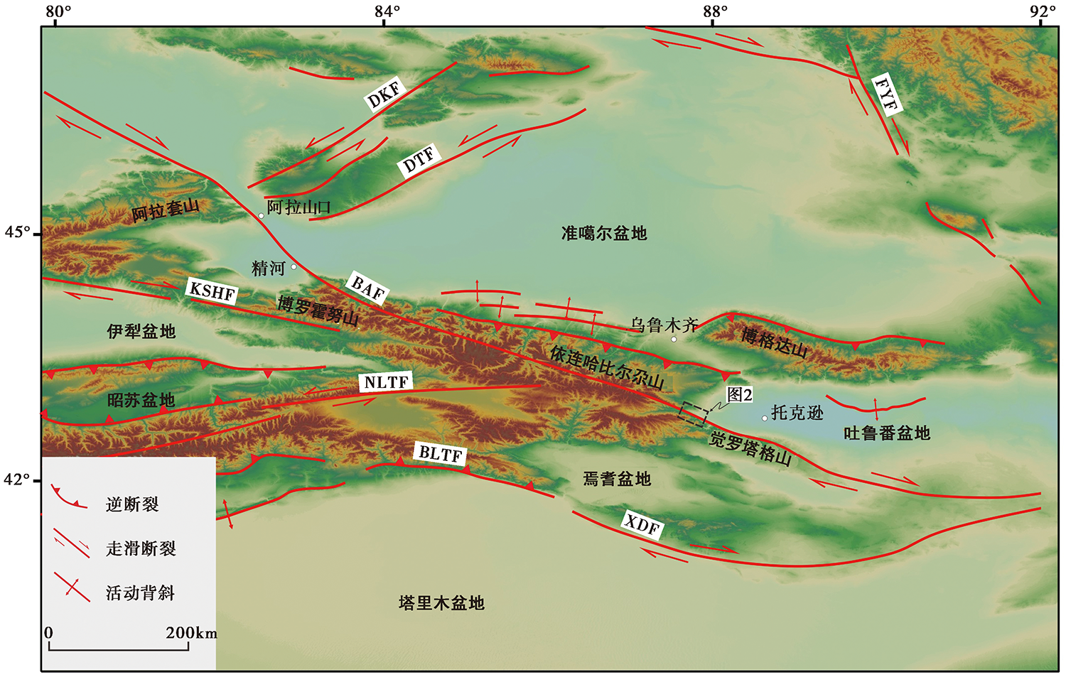
图 1 天山地区的主要活动构造 BAF 博-阿断裂; DKF 东别列克断裂; DTF 达尔布特断裂; FYF 富蕴断裂; KSHF 喀什河断裂; NLTF 那拉提斯断裂; BLTF 北轮台断裂; XDF 兴地断裂
Fig. 1 The distribution of active faults in Tianshan region.
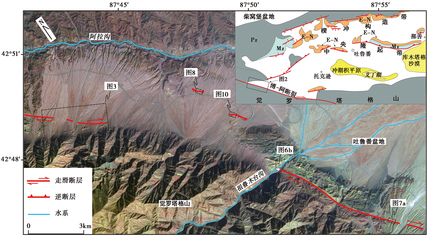
图 2 研究区的断裂分布图
Fig. 2 The distribution of fault in the study area.
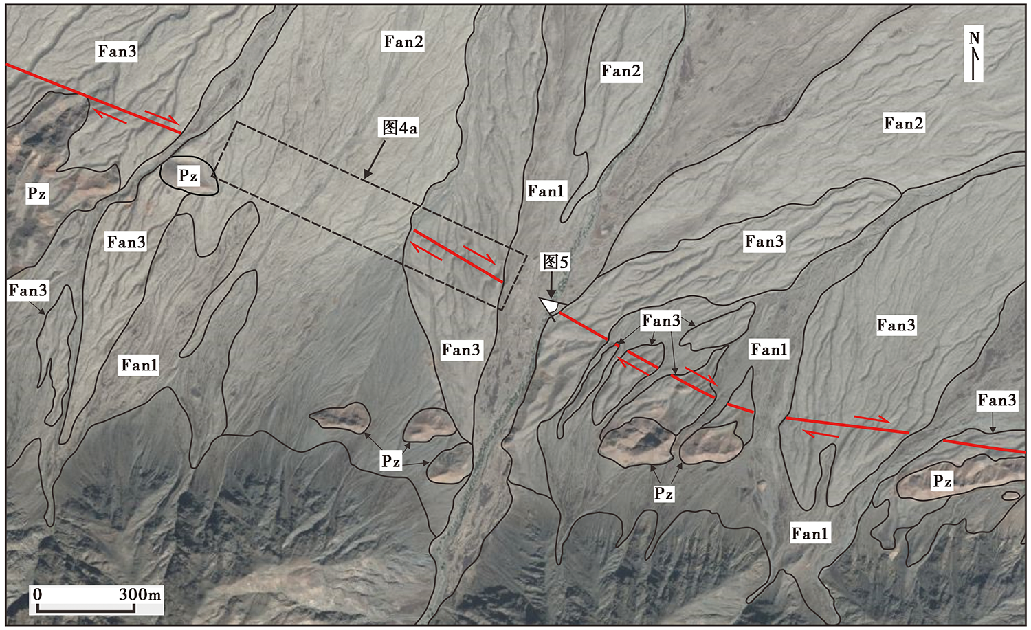
图 3 研究区内的冲洪积扇分布图
Fig. 3 The distribution of alluvial-proluvial fan in the study area.

图 4 祖鲁木台沟以西冲沟的右旋位错及陡坎剖面图
Fig. 4 Gully right-lateral displacement and scarp section in the west of Zulumutaigou.
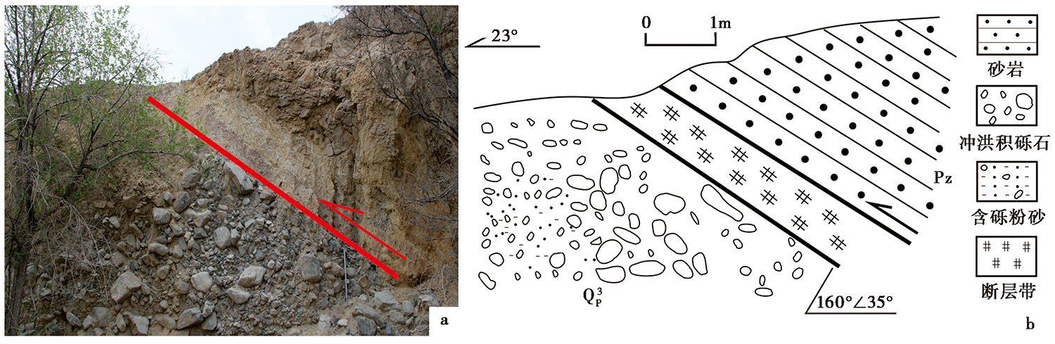
图 5 祖鲁木台沟以西断裂的剖面及素描图
Fig. 5 Fault section in the west of Zulumutaigou.

图 6 祖鲁木台沟东岸断裂的地貌特征
Fig. 6 Pictures of faulted landforms in the east of Zulumutaigou.

图 7 祖鲁木台沟以东冲沟的右旋位错
Fig. 7 Gully right-lateral displacement in the east of Zulumutaigou.
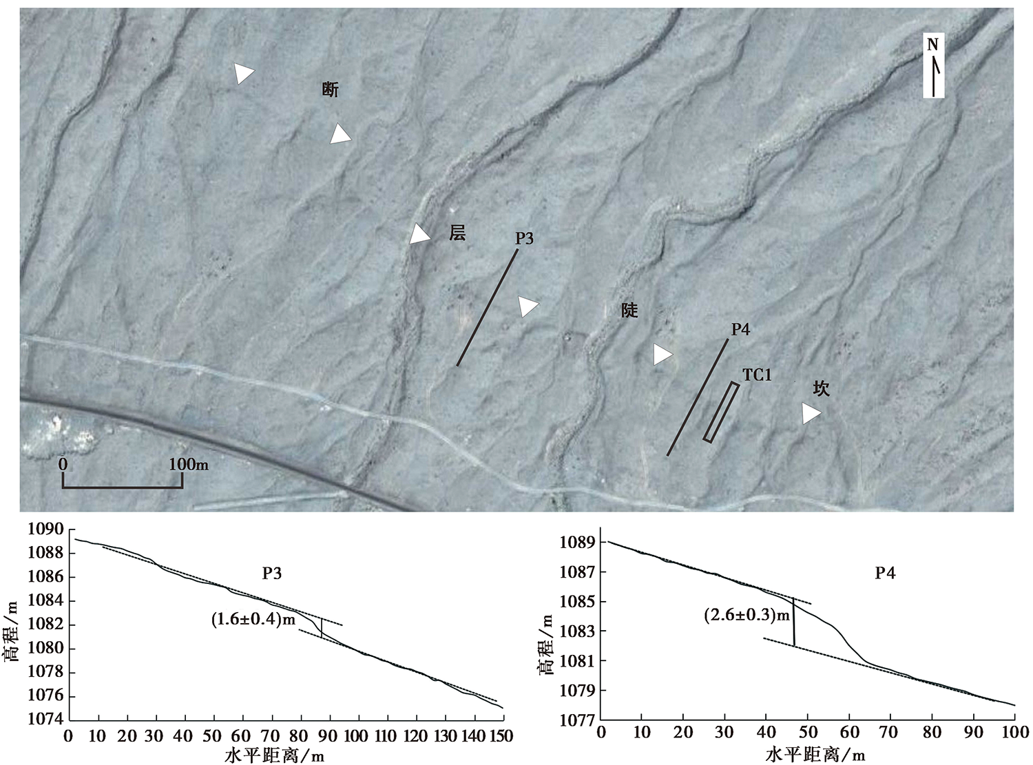
图 8 西段的陡坎影像(位置见图 2)及实测剖面
Fig. 8 Image of fault scarp(See Fig. 2 for location)and measured sections.
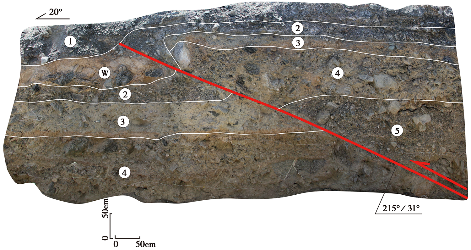
图 9 TC1的照片
Fig. 9 Photo of the trench TC1.
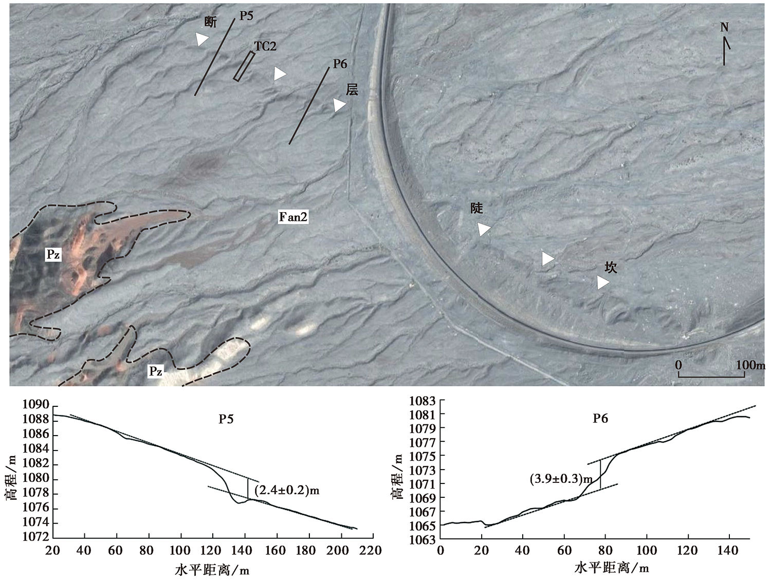
图 10 东段断层陡坎的影像(位置见图 2)及实测剖面
Fig. 10 Image of fault scarp(See Fig. 2 for location)and the measured sections.
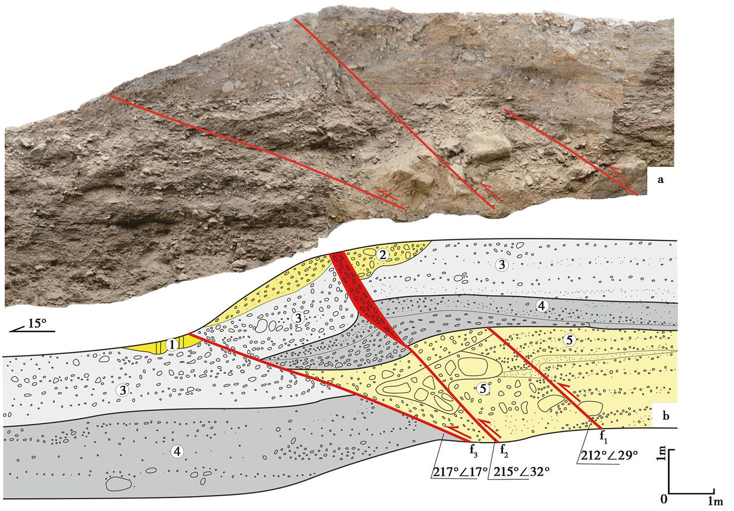
图 11 TC2的照片及素描图
Fig. 11 Photo and sketch of the trench TC2.
| [1] | 陈立春. 2011. 北天山乌鲁木齐转换区构造系晚第四纪活动性[D]. 北京: 中国地震局地质研究所:45. |
| CHEN Li-chun. 2011. Late Quaternary behavior of the active tectonic system in the Urumqi transform region of the North Tianshan[D]. Institute of Geology, China Earthquake Administration, Beijing: 45. (in Chinese) | |
| [2] | 陈正位. 2013. 构造与气候共同作用下天山北麓中更新世以来构造地貌演化过程[D]. 北京: 中国地震局地质研究所:14. |
| CHEN Zheng-wei. 2013. Surface geomorphological processes in the northern piedmont of Tian Shan responding to climate change and tectonic deformation since Middle Pleistocene[D]. Institute of Geology, China Earthquake Administration, Beijing: 14. (in Chinese) | |
| [3] | 邓起东, 冯先岳, 张培震, 等. 2000. 天山活动构造[M]. 北京: 地震出版社:5. |
| DENG Qi-dong, FENG Xian-yue, ZHANG Pei-zhen, et al. 2000. Active Tectonics of the Chinese Tianshan Mountains[M]. Seismological Press, Beijing: 5. (in Chinese) | |
| [4] |
胡宗凯, 杨晓平, 杨海波, 等. 2019. 博罗可努-阿齐克库都克断裂精河段晚更新世以来的断错地貌和走滑速率[J]. 地震地质, 41(2): 266-280. doi: 10.3969/j.issn.0253-4967.2019.02.002.
DOI |
| HU Zong-kai, YANG Xiao-ping, YANG Hai-bo, et al. 2019. Faulted landform and slip rate of the Jinghe section of the Bolokenu-Aqikekuduke Fault since the late Pleistocene[J]. Seismology and Geology, 41(2): 266-280. (in Chinese) | |
| [5] |
黄伟亮, 杨晓平, 李胜强, 等. 2018. 天山内部走滑断裂晚第四纪活动特征研究: 以开都河断裂为例[J]. 地震地质, 40(5): 1040-1058. doi: 10.3969/j.issn.0253-4967.2018.05.006.
DOI |
| HUANG Wei-liang, YANG Xiao-ping, LI Sheng-qiang, et al. 2018. The Late Quaternary activity characteristics of the strike-slip faults in the Tianshan orogenic belt: A case study of the Kaiduhe Fault[J]. Seismology and Geology, 40(5): 1040-1058. (in Chinese) | |
| [6] | 龙海英, 高国英, 聂晓红, 等. 2008. 北天山中东段中小地震震源机制解及应力场反演[J]. 地震, 28(1): 93-99. |
| LONG Hai-ying, GAO Guo-ying, NIE Xiao-hong, et al. 2008. The focal mechanism solution and stress field inversion of small and moderate earthquakes along middle-eastern part of northern Tianshan region[J]. Earthquake, 28(1): 93-99. (in Chinese) | |
| [7] | 聂晓红, 高国英. 2005. 南天山东段地震活动特征[J]. 内陆地震, 19(2): 156-163. |
| NIE Xiao-hong, GAO Guo-ying. 2005. The characteristics of seismic activity in the east of south Tianshan Mountains[J]. Inland Earthquake, 19(2): 156-163. (in Chinese) | |
| [8] | 沈军, 汪一鹏, 李莹甄, 等. 2003. 中国新疆天山博阿断裂晚第四纪右旋走滑运动特征[J]. 地震地质, 25(2): 183-194. |
| SHEN Jun, WANG Yi-peng, LI Ying-zhen, et al. 2003. Late Quaternary right-lateral strike-slip faulting along the Bolokenu-Aqikekuduke Fault in Chinese Tianshan[J]. Seismology and Geology, 25(2): 183-194. (in Chinese) | |
| [9] | 宋和平. 2005. 论新疆深大断裂特征与地震的关系(1)[J]. 内陆地震, 19(3): 193-202. |
| SONG He-ping. 2005. The relationship between characteristics of deep and big faults and earthquakes in Xinjiang(1)[J]. Inland Earthquake, 19(3): 193-202. (in Chinese) | |
| [10] | 吴传勇. 2016. 西南天山北东东走向断裂的晚第四纪活动特征及在天山构造变形中的作用[D]. 北京: 中国地震局地质研究所:118. |
| WU Chuan-yong. 2016. Late Quaternary activity of the NEE-trending faults in the southwestern Tianshan and their role in the tectonic deformation of the Tianshan Mountains[D]. Institute of Geology, China Earthquake Administration, Beijing: 118. (in Chinese) | |
| [11] | 杨少敏, 李杰, 王琪. 2008. GPS 研究天山现今变形与断层活动[J]. 中国科学(D 辑), 38(7): 872-880. |
| YANG Shao-min, LI Jie, WANG Qi. 2008. The deformation pattern and fault rate in the Tianshan Mountains inferred from GPS observations[J]. Science in China(Ser D), 38(7): 872-880. (in Chinese) | |
| [12] | 杨晓平, 邓起东, 张培震, 等. 2008. 天山山前主要推覆构造区的地壳缩短[J]. 地震地质, 30(1): 111-131. |
| YANG Xiao-ping, DENG Qi-dong, ZHANG Pei-zhen, et al. 2008. Crustal shortening of major nappe structures on the front margins of the Tianshan[J]. Seismology and Geology, 30(1): 111-131. (in Chinese) | |
| [13] | 杨晓平, 沈军. 2000. 天山内部博罗科努断裂精河-阿拉山口段晚更新世以来的活动特征[J]. 地震地质, 22(3): 305-315. |
| YANG Xiao-ping, SHEN Jun. 2000. Late Quaternary activity of Jinghe-Alashankou section of the Boluokenu Fault, interior Tianshan[J]. Seismology and Geology, 22(3): 305-315. (in Chinese) | |
| [14] | 张培震. 2003. 天山及其前陆盆地的晚新生代构造变形[J]. 科学通报, 48(24): 2499-2500. |
| ZHANG Pei-zhen. 2003. Late Cenozoic tectonic deformation of the Tianshan and its foreland basins[J]. Chinese Science Bulletin, 48(24): 2499-2500. (in Chinese) | |
| [15] | 张培震, 邓起东, 杨晓平, 等. 1996. 天山的晚新生代构造变形及其地球动力学问题[J]. 中国地震, 12(2): 127-140. |
| ZHANG Pei-zhen, DENG Qi-dong, YANG Xiao-ping, et al. 1996. Late Cenozoic tectonic deformation and mechanism along the Tianshan Mountains, northwestern China[J]. Earthquake Research in China, 12(2): 127-140. (in Chinese) | |
| [16] |
Allen M B, Windley B F, Zhang C, et al. 1993. Palaeozoic collisional tectonics and magmatism of the Chinese Tienshan, central Asia[J]. Tectonophysics, 220(1-4): 89-115.
DOI URL |
| [17] |
Avouac J P, Tapponnier P. 1993. Active thrusting and folding along the North Tien Shan and Late Cenozoic rotation of the Tarim relative to Dzungaria and Kazakhstan[J]. Journal of Geophysical Research, 98(B4): 6755-6804.
DOI URL |
| [18] |
Burtman V S, Skobelev S F, Molnar P. 1996. Late Cenozoic slip on the Talas-Ferghana Fault, the Tien Shan, central Asia[J]. Geological Society of America Bulletin, 108(8): 1004-1021.
DOI URL |
| [19] | Campbell G E, Walker R T, Abdrakhmatov K, et al. 2013. The Dzhungarian Fault: Late Quaternary tectonics and slip-rate of a major right-lateral strike-slip fault in the northern Tien Shan region[J]. Journal of Geophysical Research, 118(10): 5681-5698. |
| [20] | Chen J, Heermance R, Burbank D W, et al. 2007. Quantification of growth and lateral propagation of the Kashi anticline, southwest Chinese Tian Shan[J]. Journal of Geophysical Research, 112(B3): B03S16. |
| [21] | Selander J, Oskin M, Ormukov C, et al. 2012. Inherited strike-slip faults as an origin for basement-cored uplifts: Example of the Kungey and Zailiskey ranges, northern Tian Shan[J]. Tectonics, 31(4): TC4026. |
| [22] |
Tapponnier P, Molnar P. 1979. Active faulting and Cenozoic tectonics of the Tien Shan, Mongolia, and Baykal regions[J]. Journal of Geophysical Research, 84(B7): 3425-3459.
DOI URL |
| [23] | Thompson S C, Weldon R J, Rubi C M, et al. 2002. Late Quaternary slip rates across the central Tian Shan, Kyrgyzstan, central Asia[J]. Journal of Geophysical Research: Solid Earth, 107(B9): 2203. |
| [24] | Zubovich A V, Wang X Q, Scherba Y G, et al. 2010. GPS velocity field for the Tien Shan and surrounding regions[J]. Tectonics, 29(6): TC6014. |
| [1] | 刘瑞春, 张锦, 郭文峰, 陈慧, 郑亚迪, 成诚. 鄂尔多斯块体东南缘现今的变形特征与构造模式探讨[J]. 地震地质, 2021, 43(3): 540-558. |
| [2] | 常祖峰, 常昊, 毛泽斌, 罗林, 王琦. 中缅交界苏典断裂的最新活动特征及意义[J]. 地震地质, 2021, 43(3): 559-575. |
| [3] | 哈广浩, 任治坤, 刘金瑞, 李智敏, 李正芳, 闵伟, 周本刚. 青海都兰地区夏日哈活动断裂带的发现及其构造意义[J]. 地震地质, 2021, 43(3): 614-629. |
| [4] | 胡宗凯, 杨晓平, 杨海波, 吴国栋, 李军, 周本刚. 北天山博罗可努-阿齐克库都克断裂精河段的古地震事件[J]. 地震地质, 2020, 42(4): 773-790. |
| [5] | 胡宗凯, 杨晓平, 杨海波, 李军, 吴国栋, 黄伟亮. 博罗可努-阿齐克库都克断裂精河段晚更新世以来的断错地貌和走滑速率[J]. 地震地质, 2019, 41(2): 266-280. |
| [6] | 郭长辉, 李安, 刘睿, 张世民. 基于高分辨率影像的宽滩山北缘断裂带右旋走滑特征及其构造意义的初步研究[J]. 地震地质, 2018, 40(4): 784-800. |
| [7] | 邹小波, 袁道阳, 邵延秀, 刘兴旺, 张波, 杨海波. 采用立体像对和差分GPS揭示民乐-永昌隐伏断裂地表变形特征[J]. 地震地质, 2017, 39(6): 1198-1212. |
| [8] | 刘睿, 李安, 张世民, 陈志丹, 郭长辉. 白杨河阶地揭示的北祁连山西段晚第四纪构造变形[J]. 地震地质, 2017, 39(6): 1237-1255. |
| [9] | 雷启云, 张培震, 郑文俊, 杜鹏, 王伟涛, 俞晶星, 谢晓峰. 贺兰山西麓断裂右旋走滑的地质地貌证据及其构造意义[J]. 地震地质, 2017, 39(6): 1297-1315. |
| [10] | 王洋, 张波, 侯建军, 艾晟. 曲江断裂晚第四纪活动特征及滑动速率分析[J]. 地震地质, 2015, 37(4): 1177-1192. |
| [11] | 常祖峰. 2013年云南奔子栏M5.9地震发生的地震地质背景[J]. 地震地质, 2015, 37(1): 192-207. |
| [12] | 何付兵, 白凌燕, 王继明, 刘予, 蔡向民, 孙永华, 张磊, 方同明, 郭高轩. 夏垫断裂带深部构造特征与第四纪活动性讨论[J]. 地震地质, 2013, 35(3): 490-505. |
| [13] | 王伟涛, 张培震, 雷启云. 牛首山-罗山断裂带的变形特征及其构造意义[J]. 地震地质, 2013, 35(2): 195-207. |
| [14] | 徐锡伟, 孙鑫喆, 谭锡斌, 李康, 于贵华, Marie Etchebes, Yann Klinger, Paul Tapponnier, J. Van Der Woerd. 富蕴断裂:低应变速率条件下断层滑动习性[J]. 地震地质, 2012, (4): 606-617. |
| [15] | 潘波, 许建东, 刘启方. 1679年三河-平谷8级地震近断层强地震动的有限元模拟[J]. 地震地质, 2009, 31(1): 69-83. |
| 阅读次数 | ||||||
|
全文 |
|
|||||
|
摘要 |
|
|||||
