地震地质 ›› 2022, Vol. 44 ›› Issue (6): 1597-1614.DOI: 10.3969/j.issn.0253-4967.2022.06.014
蒋雨函1)( ), 高小其1)(), 杨朋涛1), 刘冬英1), 孙小龙1), 向阳1), 朱成英2), 汪成国2)
收稿日期:2022-03-02
修回日期:2022-06-27
出版日期:2022-12-20
发布日期:2023-01-21
通讯作者:
高小其
作者简介:蒋雨函, 女, 1994年生, 2020年于中国地震局地壳应力研究所获固体地球物理学专业硕士学位, 研究实习员, 主要从事地下流体和地球化学等研究, E-mail: jiangyh19@126.com。
基金资助:
JIANG Yu-han1)(), GAO Xiao-qi1)(), YANG Peng-tao1), LIU Dong-ying1), SUN Xiao-long1), XIANG Yang1), ZHU Cheng-ying2), WANG Cheng-guo2)
Received:2022-03-02
Revised:2022-06-27
Online:2022-12-20
Published:2023-01-21
Contact:
GAO Xiao-qi
摘要:
断层土壤气测量是揭示断层性质与断裂活动的重要地球化学方法。文中在新疆北天山2个地震危险区中的博罗科努-阿其克库都克断裂、 库松木契克山前断裂、 独山子-安集海断裂、 霍尔果斯-吐谷鲁断裂、 喀什河断裂、 那拉提断裂等6条断裂带上布设了8条断层土壤气测线, 共进行了6、 7期测量。文中依据多期断层土壤气流动测量结果, 分析了断层土壤气的空间分布特征, 并分别讨论了断裂带活动性及区域地震危险性。结果表明: 1)土壤气组分Rn是研究断裂带分布、 指示断裂破碎位置及判断断层活动性的有效气体, 在库松木契克山前断裂和霍尔果斯-吐谷鲁断裂的测线上, 除断层出露处的测点外, 还存在其他测点出现Rn浓度峰值的现象, 因此这2条断裂带除了断层出露处还存在其他断裂破碎位置。2)在库松木契克山前断裂、 那拉提断裂以及霍尔果斯-吐谷鲁断裂所布设的测线上, Rn浓度的最高值分别为99 802Bq/m3、 80 549Bq/m3、 78 834Bq/m3, 不仅高于其他断裂带测线的Rn浓度值, 还高于新疆呼图壁北断裂的Rn浓度值, 说明上述3条断裂的断层活动性较强。3)北天山温泉-精河地震危险区内小地震频率相对较低, 区域应力积累程度相对较高, 断层活动性强, 更易发生中强震, 存在一定的地震危险性。未来对北天山温泉-精河地震危险区内的断层土壤气体地球化学开展监测与深入研究, 对判断北天山地区的地震危险性具有重要意义。文中的结果可为分析新疆北天山地区断裂带释放气体特征及指导地震台站勘选、 布设和震情跟踪等提供地球化学资料与技术支撑。
中图分类号:
蒋雨函, 高小其, 杨朋涛, 刘冬英, 孙小龙, 向阳, 朱成英, 汪成国. 新疆北天山地区断裂带断层土壤气的地球化学特征[J]. 地震地质, 2022, 44(6): 1597-1614.
JIANG Yu-han, GAO Xiao-qi, YANG Peng-tao, LIU Dong-ying, SUN Xiao-long, XIANG Yang, ZHU Cheng-ying, WANG Cheng-guo. GEOCHEMICAL CHARACTERISTICS OF SOIL GAS IN THE FAULT ZONES OF NORTH TIANSHAN, XINJIANG[J]. SEISMOLOGY AND GEOLOGY, 2022, 44(6): 1597-1614.
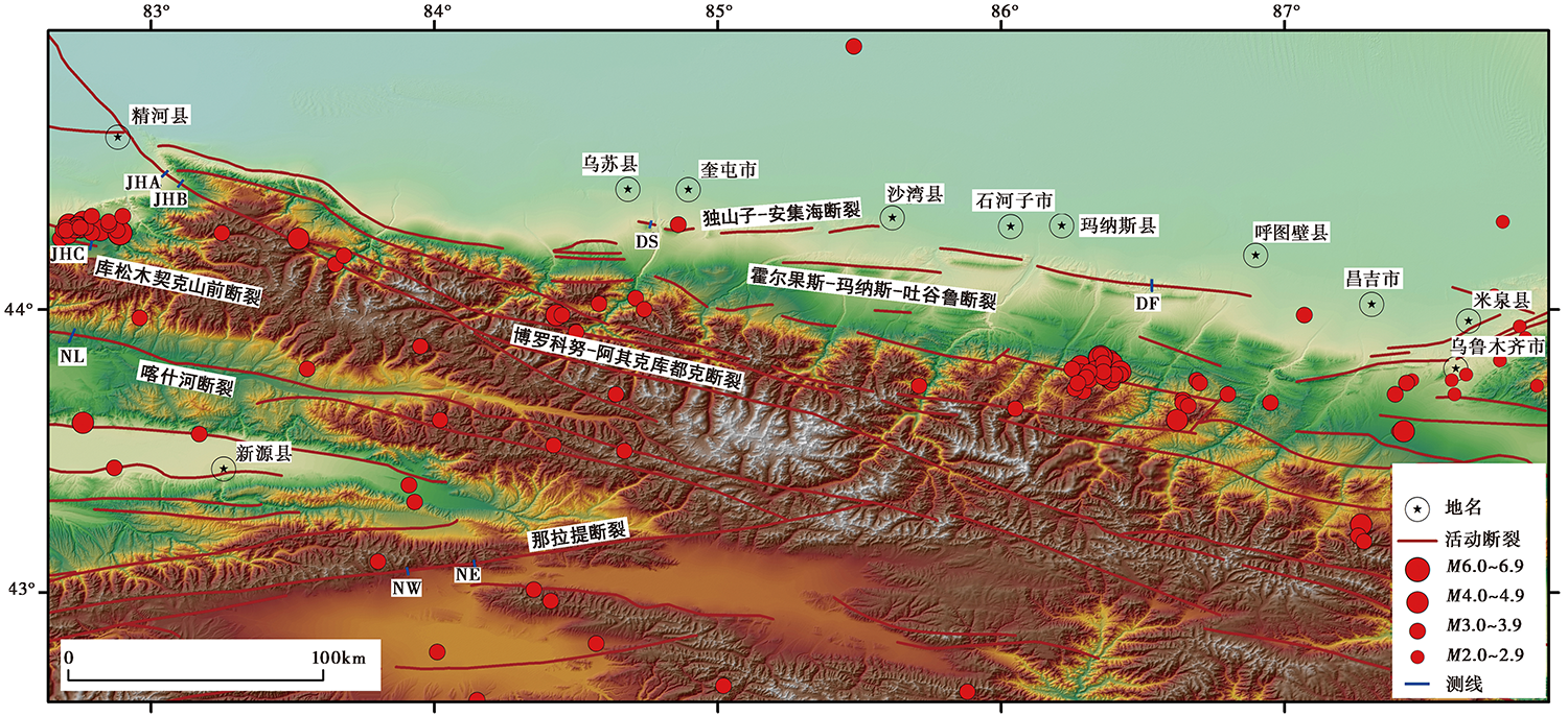
图 1 研究区及周边的地震活动、 活动断裂与测线分布图
Fig. 1 Map of seismic activity, active faults and measuring line locations in the study area and vicinity.
| 测线 | CRn/Bq·m-3 | CHg/ng·m-3 | ||||||||||
|---|---|---|---|---|---|---|---|---|---|---|---|---|
| 最小值 | 最大值 | 背景值 | 异常下限 | 最小值 | 最大值 | 背景值 | 异常下限 | 最小值 | 最大值 | 背景值 | 异常下限 | |
| JHA | 12 748 | 29 517 | 20 832 | 25 013 | 0.04 | 0.07 | 0.06 | 0.07 | 2 | 12 | 7 | 10 |
| JHB | 4 485 | 23 821 | 16 736 | 22 022 | 0.03 | 0.09 | 0.06 | 0.08 | 3 | 28 | 10 | 18 |
| JHC | 14 538 | 57 182 | 31 879 | 44 168 | 0.02 | 0.11 | 0.06 | 0.08 | 3 | 111 | 30 | 56 |
| NL | 3 409 | 50 356 | 20 338 | 31 948 | 0.03 | 0.38 | 0.16 | 0.27 | 2 | 103 | 15 | 41 |
| NW | 16 858 | 64 500 | 39 585 | 53 312 | 0.05 | 2.65 | 0.28 | 0.94 | 4 | 19 | 9 | 13 |
| NE | 13 345 | 31 744 | 23 005 | 28 095 | 0.05 | 0.16 | 0.10 | 0.13 | 3 | 27 | 15 | 23 |
| DS | 8 029 | 41 153 | 24 696 | 33 429 | 0.04 | 0.10 | 0.07 | 0.09 | 2 | 54 | 17 | 30 |
| DF | 14 326 | 78 834 | 29 680 | 45 770 | 0.06 | 1.54 | 0.36 | 0.78 | 5 | 56 | 21 | 37 |
表1 2017年8月北天山断裂带土壤气Rn、 CO2、 Hg的浓度
Table1 Soil gas Rn, CO2 and Hg concentrations in the north Tianshan fault zone in August 2017
| 测线 | CRn/Bq·m-3 | CHg/ng·m-3 | ||||||||||
|---|---|---|---|---|---|---|---|---|---|---|---|---|
| 最小值 | 最大值 | 背景值 | 异常下限 | 最小值 | 最大值 | 背景值 | 异常下限 | 最小值 | 最大值 | 背景值 | 异常下限 | |
| JHA | 12 748 | 29 517 | 20 832 | 25 013 | 0.04 | 0.07 | 0.06 | 0.07 | 2 | 12 | 7 | 10 |
| JHB | 4 485 | 23 821 | 16 736 | 22 022 | 0.03 | 0.09 | 0.06 | 0.08 | 3 | 28 | 10 | 18 |
| JHC | 14 538 | 57 182 | 31 879 | 44 168 | 0.02 | 0.11 | 0.06 | 0.08 | 3 | 111 | 30 | 56 |
| NL | 3 409 | 50 356 | 20 338 | 31 948 | 0.03 | 0.38 | 0.16 | 0.27 | 2 | 103 | 15 | 41 |
| NW | 16 858 | 64 500 | 39 585 | 53 312 | 0.05 | 2.65 | 0.28 | 0.94 | 4 | 19 | 9 | 13 |
| NE | 13 345 | 31 744 | 23 005 | 28 095 | 0.05 | 0.16 | 0.10 | 0.13 | 3 | 27 | 15 | 23 |
| DS | 8 029 | 41 153 | 24 696 | 33 429 | 0.04 | 0.10 | 0.07 | 0.09 | 2 | 54 | 17 | 30 |
| DF | 14 326 | 78 834 | 29 680 | 45 770 | 0.06 | 1.54 | 0.36 | 0.78 | 5 | 56 | 21 | 37 |
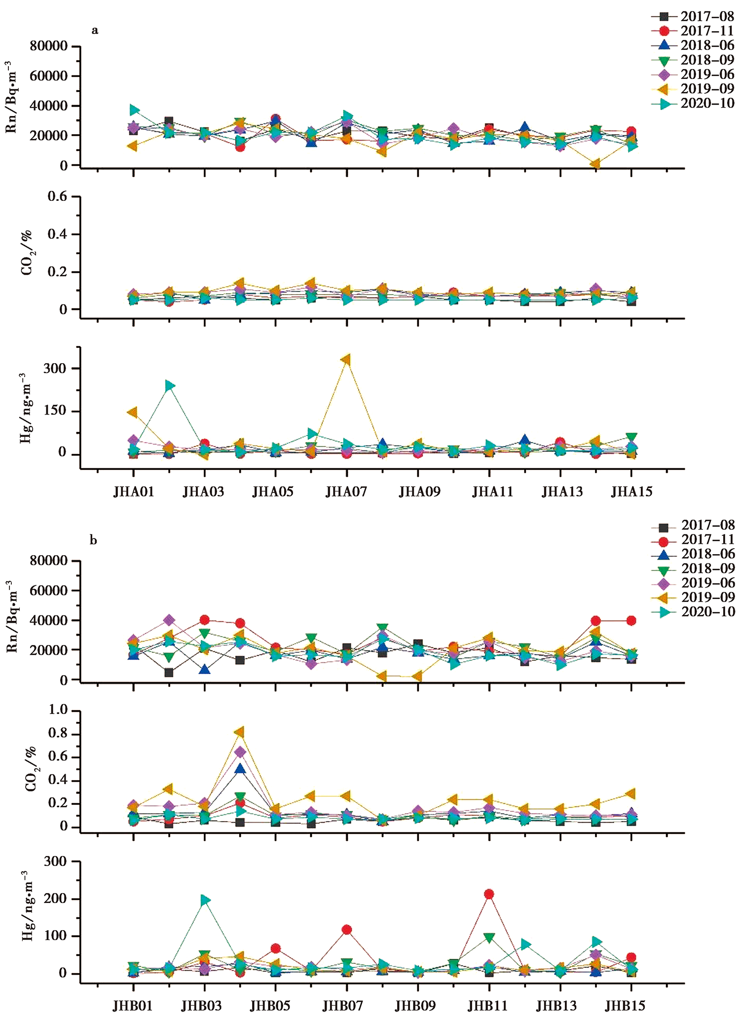
图 2 博阿断裂带测线的Rn、 CO2、 Hg浓度变化曲线
Fig. 2 Variations of Rn, CO2 and Hg concentrations on the measuring line of the Bo-A fault zone.
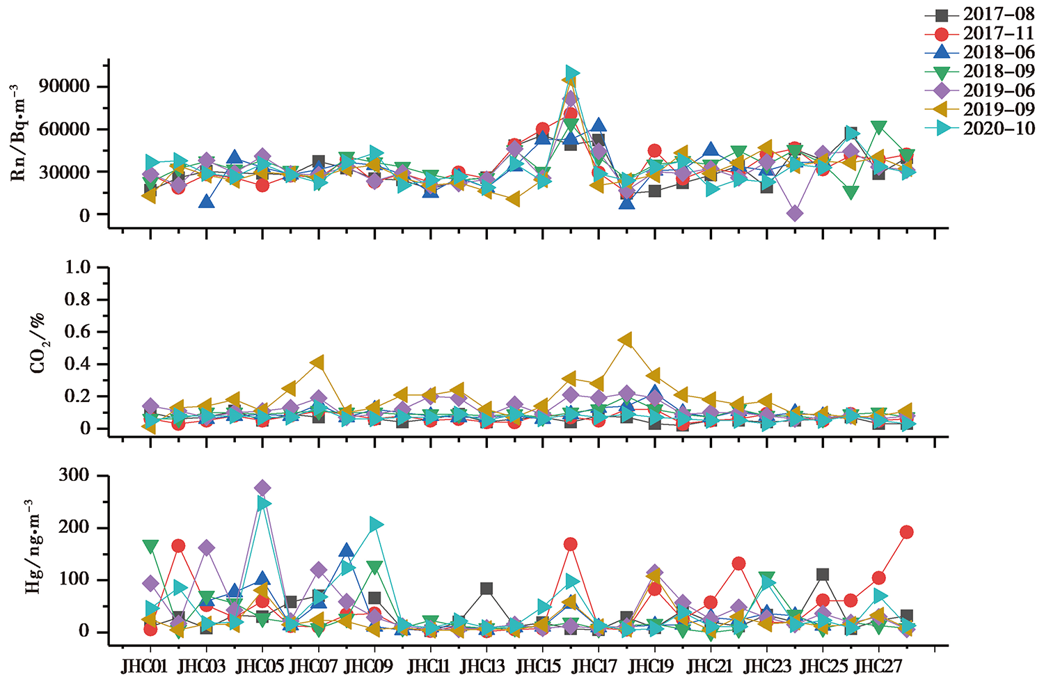
图 3 库松木契克山前断裂带测线的Rn、 CO2、 Hg浓度变化曲线
Fig. 3 Variations of Rn, CO2, Hg concentrations on the measuring line of Kusongmuqike mountain piedmont fault zone.
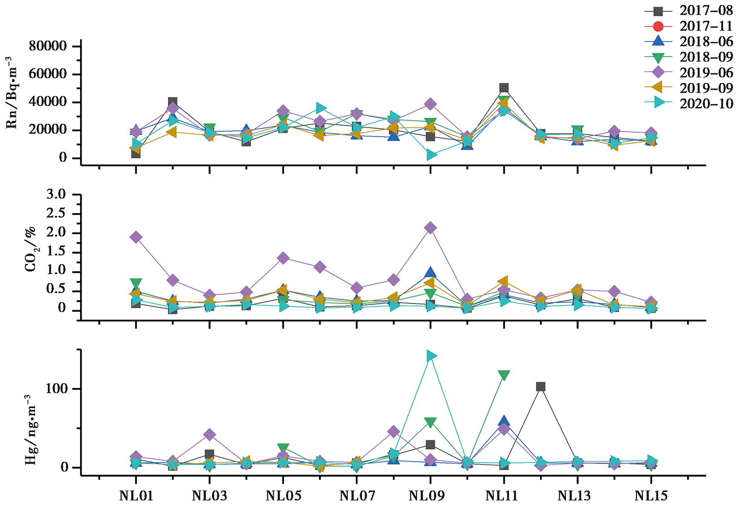
图 4 喀什河断裂带测线的Rn、 CO2、 Hg浓度变化曲线
Fig. 4 Variations of Rn, CO2, Hg concentrations on the measuring line of the Kashi River fault zone.
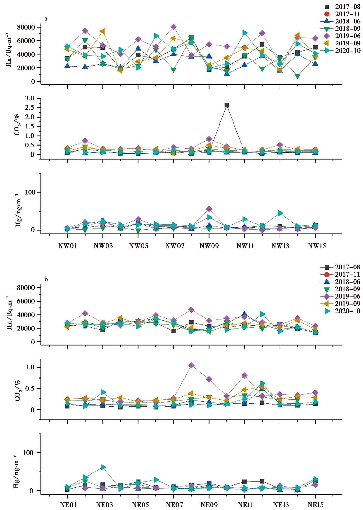
图 5 那拉提断裂带测线的Rn、 CO2、 Hg浓度变化曲线
Fig. 5 Variations of Rn, CO2, Hg concentrations on the measuring line of Nalati fault zone.
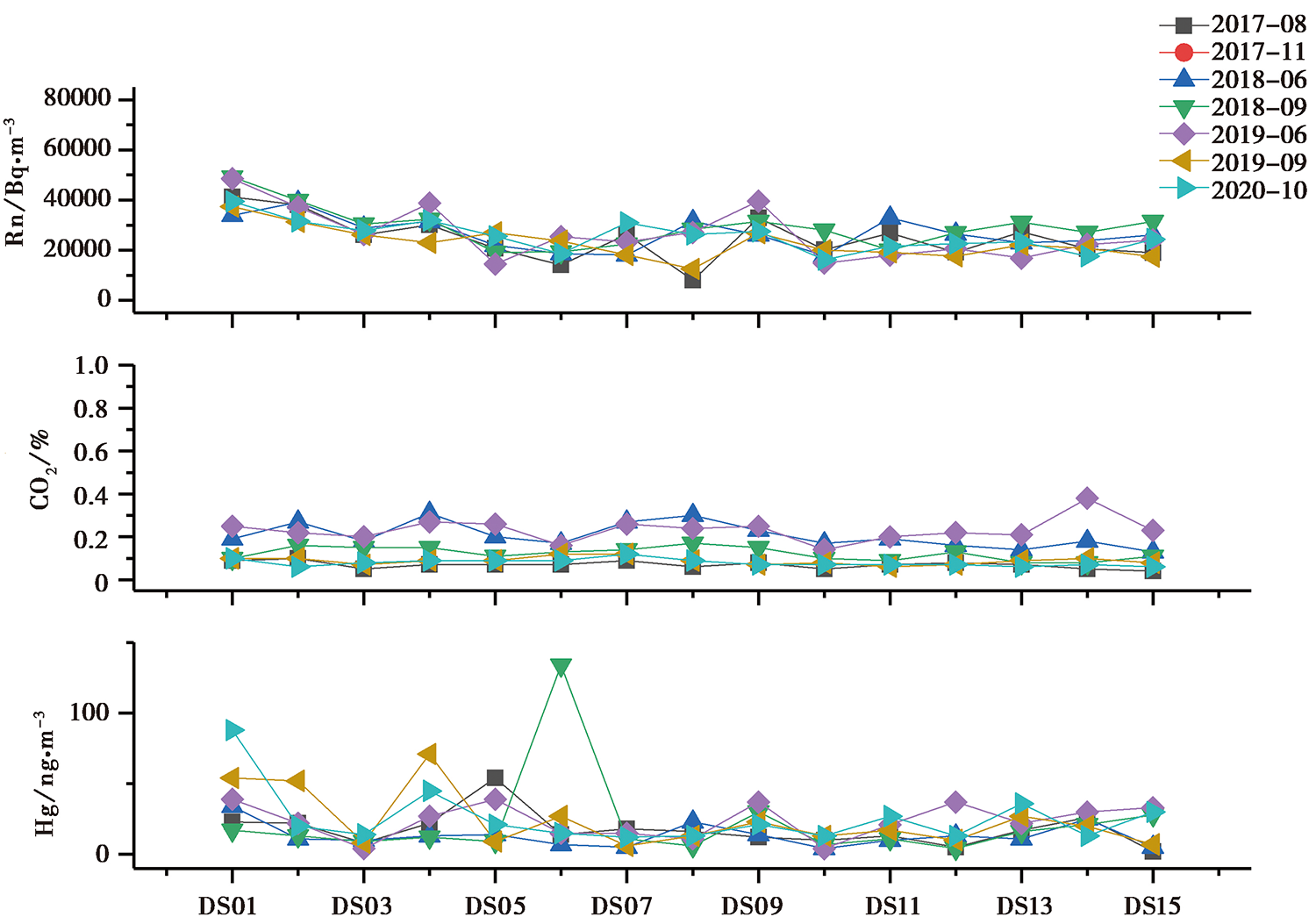
图 6 独山子-安集海断裂带测线Rn、 CO2、 Hg浓度变化曲线
Fig. 6 Variations of Rn, CO2, Hg concentrations on the measuring line of Dushanzi-Anjihai fault zone.
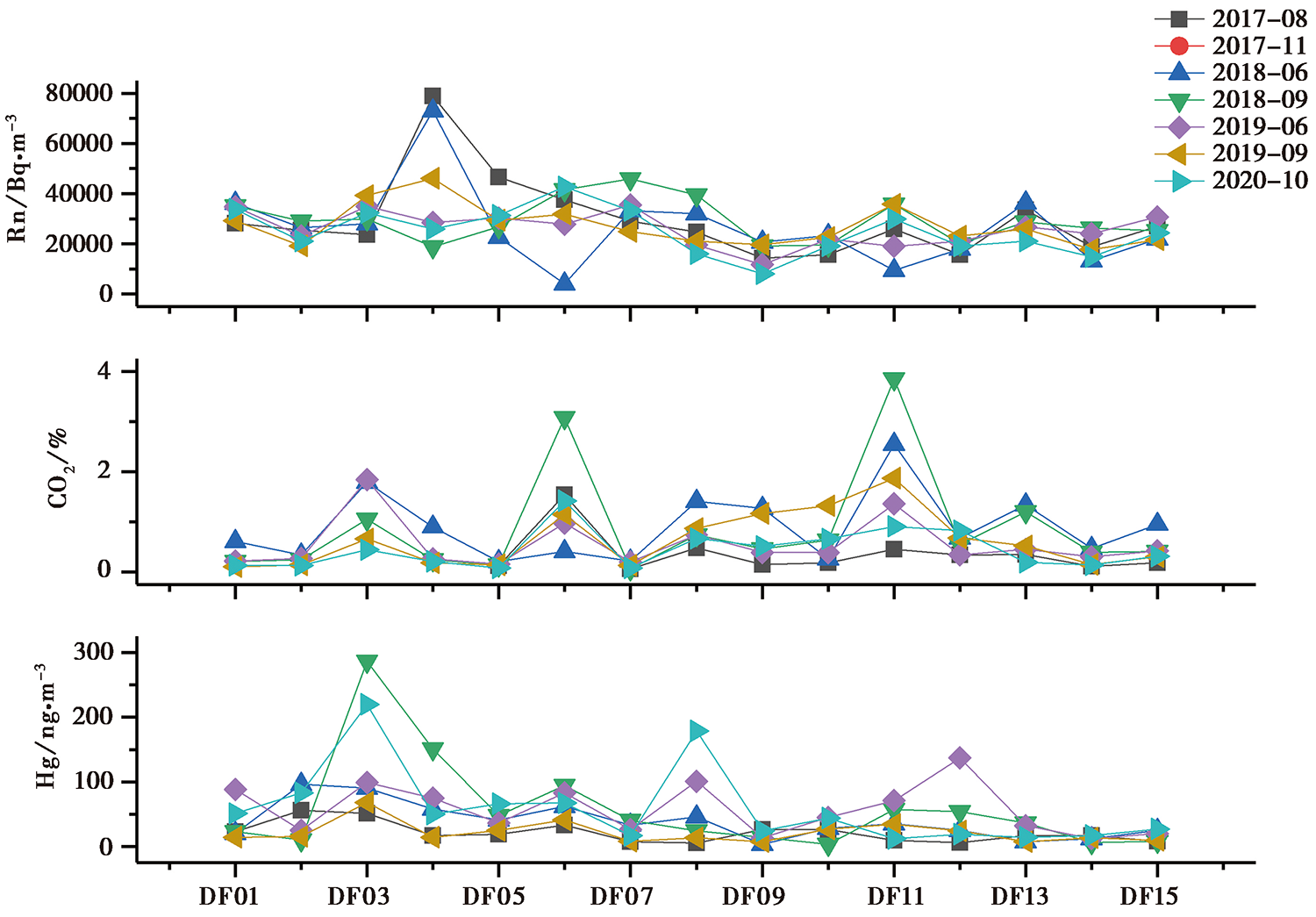
图 7 霍尔果斯-吐谷鲁断裂带测线的Rn、 CO2、 Hg浓度变化曲线
Fig. 7 Variations of Rn, CO2 and Hg concentrations on the measuring line in the Horgos-Tugulu fault zone.
| 日期 | 震级 | 震中坐标 | 震中参考地点 | Δ/km | |||||||
|---|---|---|---|---|---|---|---|---|---|---|---|
| JHA | JHB | JHC | NL | NW | NE | DS | DF | ||||
| 2016-12-08 | 6.2 | 43.83°N, 86.35°E | 呼图壁县 | 273 | 268 | 289 | 301 | 216 | 198 | 135 | 31 |
| 2017-08-09 | 6.6 | 44.27°N, 82.89°E | 精河县 | 26 | 24 | 8 | 44 | 162 | 169 | 152 | 291 |
| 2017-09-16 | 5.7 | 42.11°N, 83.43°E | 库车县 | 265 | 260 | 247 | 215 | 108 | 119 | 269 | 333 |
| 2018-10-16 | 5.4 | 44.19°N, 82.53°E | 精河县 | 52 | 52 | 24 | 28 | 172 | 182 | 181 | 319 |
表2 5级以上地震与测线的震中距
Table2 Epicentral distance of earthquakes with magnitude 5 and above to the measuring lines
| 日期 | 震级 | 震中坐标 | 震中参考地点 | Δ/km | |||||||
|---|---|---|---|---|---|---|---|---|---|---|---|
| JHA | JHB | JHC | NL | NW | NE | DS | DF | ||||
| 2016-12-08 | 6.2 | 43.83°N, 86.35°E | 呼图壁县 | 273 | 268 | 289 | 301 | 216 | 198 | 135 | 31 |
| 2017-08-09 | 6.6 | 44.27°N, 82.89°E | 精河县 | 26 | 24 | 8 | 44 | 162 | 169 | 152 | 291 |
| 2017-09-16 | 5.7 | 42.11°N, 83.43°E | 库车县 | 265 | 260 | 247 | 215 | 108 | 119 | 269 | 333 |
| 2018-10-16 | 5.4 | 44.19°N, 82.53°E | 精河县 | 52 | 52 | 24 | 28 | 172 | 182 | 181 | 319 |
| [1] | 白兰淑, 刘杰, 张莹莹, 等. 2017. 2017年精河6.6级地震余震序列重新定位和发震构造[J]. 中国地震, 33(4): 703-711. |
| BAI Lan-shu, LIU Jie, ZHANG Ying-ying, et al. 2017. Relocation of the 2017 MS6.6 Jinghe, Xinjiang earthquake sequence and its seismogenic structure[J]. Earthquake Research in China, 33(4): 703-711. (in Chinese) | |
| [2] | 陈建波, 罗福忠, 胡伟华, 等. 2021. 新疆北天山乌苏南断层晚第四纪活动特征及其构造意义[J]. 内陆地震, 35(1): 30-37. |
| CHEN Jian-bo, LUO Fu-zhong, HU Wei-hua, et al. 2021. Late Quaternary activity characteristics and tectonic significance of Wusunan Fault in north Tianshan, Xinjiang[J]. Inland Earthquake, 35(1): 30-37. (in Chinese) | |
| [3] | 陈建波, 沈军, 李军, 等. 2007. 北天山西段库松木楔克山山前断层新活动特征初探[J]. 西北地震学报, 29(4): 335-340. |
| CHEN Jian-bo, SHEN Jun, LI Jun, et al. 2007. Preliminary study on new active characteristics of Kusongmuxieke mountain front fault in the west segment of north Tianshan[J]. Northwestern Seismological Journal, 29(4): 335-340. (in Chinese) | |
| [4] | 邓起东, 冯先岳, 张培震, 等. 1999. 乌鲁木齐山前坳陷逆断裂-褶皱带及其形成机制[J]. 地学前缘, 6(4): 191-201. |
| DENG Qi-dong, FENG Xian-yue, ZHANG Pei-zhen, et al. 1999. Reverse fault and fold zone in the Urumqi range-front depression of the northern Tianshan and its genetic mechanism[J]. Earth Science Frontiers, 6(4): 191-201. (in Chinese) | |
| [5] | 邓起东, 冯先岳, 张培震, 等. 2000. 天山活动构造[M]. 北京: 地震出版社. |
| DENG Qi-dong, FENG Xian-yue, ZHANG Pei-zhen, et al. 2000. Active Tectonics in the Tianshan[M]. Seismological Press, Beijing. (in Chinese) | |
| [6] | 杜乐天. 2005. 地球排气作用的重大意义及研究进展[J]. 地质论评, 51(2): 174-180. |
| DU Le-tian. 2005. Significance of earth degassing and its research progress[J]. Geological Review, 51(2): 174-180. (in Chinese) | |
| [7] | 高朝军, 韩立波, 蒋长胜, 等. 2017. 博阿断裂西段重复地震识别及断层深部滑移速率研究[J]. 地震学报, 39(3): 307-314. |
| GAO Chao-jun, HAN Li-bo, JIANG Chang-sheng, et al. 2017. Repeating earthquake identification and deep slip rates for western Bolokenu-Aqikekuduke Fault[J]. Acta Seismologica Sinica, 39(3): 307-314. (in Chinese) | |
| [8] | 蒋雨函, 高小其, 张磊, 等. 2021. 新疆呼图壁地下储气库断层气体地球化学特征研究[J]. 中国地震, 37(4): 749-766. |
| JIANG Yu-han, GAO Xiao-qi, ZHANG Lei, et al. 2021. Geochemical characteristics of soil gas along faults in Hutubi underground gas storage, Xinjiang[J]. Earthquake Research in China, 37(4): 749-766. (in Chinese) | |
| [9] | 荆燕, 赵营海, 张鸿旭, 等. 2005. 独山子-安集海断裂单基线双分量斜跨断层监测研究[J]. 地震研究, 28(2): 185-188. |
| JING Yan, ZHAO Ying-hai, ZHANG Hong-xu, et al. 2005. Monitoring of Dushanzi-Anjihai Fault with single-baseline, two-component, obliquely-crossing-fault instruments[J]. Journal of Seismological Research, 28(2): 185-188. (in Chinese) | |
| [10] | 李杰, 陈刚, 魏文薪, 等. 2016. 基于GPS观测的北天山主要断裂现今构造运动特征研究[J]. 地震学报, 38(5): 751-760. |
| LI Jie, CHEN Gang, WEI Wen-xin, et al. 2016. Characteristics of present-day tectonics movement of typical faults in northern Tianshan Mountains deduced from GPS observation[J]. Acta Seismologica Sinica, 38(5): 751-760. (in Chinese) | |
| [11] | 李艳永, 王成虎. 2019. 2017年8月9日精河 MS6.6 地震序列震源机制解及震源处应力场特征[J]. 地震工程学报, 41(5): 1280-1289. |
| LI Yan-yong, WANG Cheng-hu. 2019. Focal mechanism solution and stress field characteristics in source area of Jinghe MS6.6 earthquake sequence on August 9, 2017[J]. China Earthquake Engineering Journal, 41(5): 1280-1289. (in Chinese) | |
| [12] | 刘冠中, 王建军, 王在华, 等. 2009. 独山子山前断层现今活动特征与形变异常研究[J]. 地震研究, 32(2): 125-131. |
| LIU Guan-zhong, WANG Jian-jun, WANG Zai-hua, et al. 2009. Movement character and deformation anomaly research of Dushanzi-Anjihai Fault nowadays[J]. Journal of Seismological Research, 32(2): 125-131. (in Chinese) | |
| [13] | 刘建明, 高荣, 王琼, 等. 2017. 2017年8月9日精河6.6级地震序列重定位与发震构造初步研究[J]. 中国地震, 33(4): 663-670. |
| LIU Jian-ming, GAO Rong, WANG Qiong, et al. 2017. Relocation of the Jinghe MS6.6 earthquake sequence on August 9, 2017 and analysis of the seismogenic structure[J]. Earthquake Research in China, 33(4): 663-670. (in Chinese) | |
| [14] | 刘耀炜, 陈华静, 车用太. 2006. 我国地震地下流体观测研究40年发展与展望[J]. 国际地震动态, (7): 3-12. |
| LIU Yao-wei, CHEN Hua-jing, CHE Yong-tai. 2006. Retrospect and prospect of observation and study on seismic underground fluid in China[J]. Recent Developments in World Seismology, (7): 3-12. (in Chinese) | |
| [15] | 刘兆才. 2019. 天山地区构造应力场特征与2017年精河 MS6.6 地震发震断层性质的厘定[D]. 廊坊: 防灾科技学院. |
| LIU Zhao-cai. 2019. The tectonic stress field in Tian Shan area and slip property of seismogenic fault of the 2017 Jinghe MS6.6 earthquake[D]. Institute of Disaster Prevention, Langfang. (in Chinese) | |
| [16] | 吕红华, 李有利. 2010. 天山北麓活动背斜带的变形特征[J]. 第四纪研究, 30(5): 1003-1011. |
| LÜ Hong-hua, LI You-li. 2010. Tectonic deformation of active fault-related fold belts in the piedmont of the central Tianshan Mountains, NW China[J]. Quaternary Sciences, 30(5): 1003-1011. (in Chinese) | |
| [17] | 钱青, 徐守礼, 何国琦, 等. 2007. 那拉提山北缘寒武纪玄武岩的元素地球化学特征及构造意义[J]. 岩石学报, 23(7): 1708-1720. |
| QIAN Qing, XU Shou-li, HE Guo-qi, et al. 2007. Elemental geochemistry and tectonic significance of Cambrian basalts from the northern side of the Nalati Mountain[J]. Acta Petrologica Sinica, 23(7): 1708-1720. (in Chinese) | |
| [18] | 沈军, 汪一鹏, 李莹甄, 等. 2003. 中国新疆天山博阿断裂晚第四纪右旋走滑运动特征[J]. 地震地质, 25(2): 183-194. |
| SHEN Jun, WANG Yi-peng, LI Ying-zhen, et al. 2003. Late Quaternary right-lateral strike-slip faulting along the Bolokenu-Aqikekuduke Fault in Chinese Tian Shan[J]. Seismology and Geology, 25(2): 183-194. (in Chinese) | |
| [19] |
孙小龙, 王广才, 邵志刚, 等. 2016. 海原断裂带土壤气与地下水地球化学特征研究[J]. 地学前缘, 23(3): 140-150.
DOI |
|
SUN Xiao-long, WANG Guang-cai, SHAO Zhi-gang, et al. 2016. Geochemical characteristics of emergent gas and groundwater in Haiyuan fault zone[J]. Earth Science Frontiers, 23(3): 140-150. (in Chinese)
DOI |
|
| [20] |
王兆明, 罗晓容, 刘楼军, 等. 2006. 准噶尔盆地南缘霍-玛-吐断层活动特征及成藏过程[J]. 石油学报, 27(5): 28-34.
DOI |
|
WANG Zhao-ming, LUO Xiao-rong, LIU Lou-jun, et al. 2006. Active features of Huo-Ma-Tu Fault and hydrocarbon accumulation in the southern Junggar Basin[J]. Acta Petrolei Sinica, 27(5): 28-34. (in Chinese)
DOI |
|
| [21] | 吴传勇, 吴国栋, 沈军, 等. 2014. 那拉提断裂晚第四纪活动及其反映的天山内部构造变形[J]. 第四纪研究, 34(2): 269-280. |
| WU Chuan-yong, WU Guo-dong, SHEN Jun, et al. 2014. The Late-Quaternary activity of the Nalati Fault and its implications for the crustal deformation in the interior of the Tianshan Mountains[J]. Quaternary Sciences, 34(2): 269-280. (in Chinese) | |
| [22] | 吴国栋, 尹光华. 2010. 新疆伊犁喀什河断裂带分段性研究[J]. 内陆地震, 24(1): 25-30. |
| WU Guo-dong, YIN Guang-hua. 2010. Research on subsection of Kashi River fault zone in Ili of Xinjiang[J]. Inland Earthquake, 24(1): 25-30. (in Chinese) | |
| [23] |
杨文, 程佳, 姚琪, 等. 2018. 2016年新疆呼图壁6.2级地震发震构造[J]. 地震地质, 40(5): 1100-1114. doi: 10.3969/j.issn.0253-4967.2018.05.010.
DOI |
|
YANG Wen, CHENG Jia, YAO Qi, et al. 2018. The preliminary study on the seismogenic structure of the Hutubi MS6.2 earthquake[J]. Seismology and Geology, 40(5): 1100-1114. doi: 10.3969/j.issn.0253-4967.2018.05.010. (in Chinese)
DOI |
|
| [24] | 杨晓平, 邓起东, 张培震, 等. 2008. 天山山前主要推覆构造区的地壳缩短[J]. 地震地质, 30(1): 111-131. |
| YANG Xiao-ping, DENG Qi-dong, ZHANG Pei-zhen, et al. 2008. Crustal shortening of major nappe structures on the front margins of the Tianshan[J]. Seismology and Geology, 30(1): 111-131. (in Chinese) | |
| [25] | 杨晓平, 沈军. 2000. 天山内部博罗可努断裂精河-阿拉山口段晚更新世以来的活动特征[J]. 地震地质, 22(3): 305-315. |
| YANG Xiao-ping, SHEN Jun. 2000. Late Quaternary activity of Jinghe-Alashankou section of the Boluokenu Fault, interior Tianshan[J]. Seismology and Geology, 22(3): 305-315. (in Chinese) | |
| [26] | 张冠亚, 周晓成, 李营, 等. 2015. 怀安盆地北缘断裂东段土壤气体地球化学特征[J]. 地震, 35(3): 113-122. |
| ZHANG Guan-ya, ZHOU Xiao-cheng, LI Ying, et al. 2015. Geochemical characteristics of soil gas in the eastern segment of the north margin fault of the Huai'an Basin, Hebei Province[J]. Earthquake, 35(3): 113-122. (in Chinese) | |
| [27] | 张慧, 张新基, 苏鹤军, 等. 2010. 兰州市活动断层土壤气汞、 氡地球化学特征场地试验[J]. 西北地震学报, 32(3): 273-278. |
| ZHANG Hui, ZHANG Xin-ji, SU He-jun, et al. 2010. Field test on the geochemical features of radon and mercury from soil gas on the active faults in Lanzhou[J]. Northwestern Seismological Journal, 32(3): 273-278. (in Chinese) | |
| [28] | 张杰, 王成虎, 贾晋, 等. 2018. 基于实测应力数据的北天山西部区域断层滑动趋势分析[J]. 地震工程学报, 40(1): 73-78. |
| ZHANG Jie, WANG Cheng-hu, JIA Jin, et al. 2018. Fault slip tendency in the western area of north Tianshan based on measured in-situ stress data[J]. China Earthquake Engineering Journal, 40(1): 73-78. (in Chinese) | |
| [29] |
张磊, 高小其, 包创, 等. 2018. 呼图壁地下储气库构造气体地球化学特征[J]. 地震地质, 40(5): 1059-1071. doi: 10.3969/j.issn.0253-4967.2018.05.007.
DOI |
| ZHANG Lei, GAO Xiao-qi, BAO Chuang, et al. 2018. Geochemical characteristics of tectonic gas in Hutubi underground gas storage[J]. Seismology and Geology, 40(5): 1059-1071. (in Chinese) | |
| [30] | 张培震, 邓起东, 杨晓平, 等. 1996. 天山的晚新生代构造变形及其地球动力学问题[J]. 中国地震, 12(2): 23-36. |
| ZHANG Pei-zhen, DENG Qi-dong, YANG Xiao-ping, et al. 1996. Late Cenozoic tectonic deformation and mechanism along the Tianshan Mountains, northwestern China[J]. Earthquake Research in China, 12(2): 23-36. (in Chinese) | |
| [31] |
张志斌, 赵晓成, 任林. 2020. 新疆天山中段的震源机制解与构造应力场特征分析[J]. 地震地质, 42(3): 595-611. doi: 10.3969/j.issn.0253-4967.2020.03.004.
DOI |
| ZHANG Zhi-bin, ZHAO Xiao-cheng, REN Lin. 2020. Focal mechanism solution and tectonic stress field characteristics of the middle Tianshan Mountains, Xinjiang[J]. Seismology and Geology, 42(3): 595-611. (in Chinese) | |
| [32] | 周晓成, 郭文生, 杜建国, 等. 2007. 呼和浩特地区隐伏断层土壤气氡、 汞地球化学特征[J]. 地震, 27(1): 70-76. |
| ZHOU Xiao-cheng, GUO Wen-sheng, DU Jian-guo, et al. 2007. The geochemical characteristics of radon and mercury in the soil gas of buried faults in the Hohhot district[J]. Earthquake, 27(1): 70-76. (in Chinese) | |
| [33] | 周晓成, 孙凤霞, 陈志, 等. 2017. 汶川 MS8.0 地震破裂带CO2、 CH4、 Rn和Hg脱气强度[J]. 岩石学报, 33(1): 291-303. |
| ZHOU Xiao-cheng, SUN Feng-xia, CHEN Zhi, et al. 2017. Degassing of CO2, CH4, Rn and Hg in the rupture zones produced by Wenchuan MS8.0 earthquake[J]. Acta Petrologica Sinica, 33(1): 291-303. (in Chinese) | |
| [34] | 朱海之, 陈杰. 1990. 新疆独山子山前活断层和活褶皱及古地震研究[J]. 内陆地震, 4(2): 97-106. |
| ZHU Hai-zhi, CHEN Jie. 1990. The discovery and research of active faults, active folds and paleoearthquakes on Dushanzi piedmont[J]. Inland Earthquake, 4(2): 97-106. (in Chinese) | |
| [35] |
朱爽, 梁洪宝, 魏文薪, 等. 2021. 天山地震带主要活动断层现今的滑动速率及其地震矩亏损[J]. 地震地质, 43(1): 249-261. doi: 10.3969/j.issn.0253-4967.2021.01.015.
DOI |
| ZHU Shuang, LIANG Hong-bao, WEI Wen-xin, et al. 2021. Slip rates and seismic moment deficits on major faults in the Tianshan region[J]. Seismology and Geology, 43(1): 249-261. (in Chinese) | |
| [36] |
Annunziatellis A, Beaubien S, Bigi S, et al. 2008. Gas migration along fault systems and through the vadose zone in the Latera caldera(central Italy): Implications for CO2 geological storage[J]. International Journal of Greenhouse Gas Control, 2(3): 353-372.
DOI URL |
| [37] |
Chiodini G, Caliro S, Cardellini C, et al. 2011. Geochemical evidence for and characterization of CO2 rich gas sources in the epicentral area of the Abruzzo 2009 earthquakes[J]. Earth and Planetary Science Letters, 304(3-4): 389-398.
DOI URL |
| [38] | Ciotoli G, Lombardi S, Annunziatellis A. 2007. Geostatistical analysis of soil gas data in a high seismic intermontane basin: Fucino Plain, central Italy[J]. Journal of Geophysical Research Atmospheres, 112(B5): 2637-2655. |
| [39] |
Etiope G, Martinelli G. 2002. Migration of carrier and trace gases in the geosphere: An overview[J]. Physics of the Earth and Planetary Interiors, 129(3): 185-204.
DOI URL |
| [40] |
Fu C, Yang T F, Du J, et al. 2008. Variations of helium and radon concentrations in soil gases from an active fault zone in southern Taiwan[J]. Radiation Measurements, 43: S348-S352.
DOI URL |
| [41] | Li Y, Du J, Wang X, et al. 2013. Spatial variations of soil gas geochemistry in the Tangshan area of northern China[J]. Terrastrial, Atmospheric, and Oceanic Sciences, 24(3): 323-332. |
| [42] |
Sun X, Si X, Xiang Y, et al. 2017. Soil mercury spatial variations in the fault zone and corresponding influence factors[J]. Terrestrial, Atmospheric and Oceanic Sciences, 28(3): 283-294.
DOI URL |
| [43] |
Toutain J, Baubron J. 1999. Gas geochemistry and seismotectonics: A review[J]. Tectonophysics, 304(1): 1-27.
DOI URL |
| [44] |
Walia V, Mahajan S, Kumar A, et al. 2008. Fault delineation study using soil-gas method in the Dharamsala area, NW Himalayas, India[J]. Radiation Measurements, 43: S337-S342.
DOI URL |
| [45] |
Yang T F, Chou C Y, Chen C, et al. 2003. Exhalation of radon and its carrier gases in SW Taiwan[J]. Radiation Measurements, 36(1): 425-429.
DOI URL |
| [46] |
Yang T F, Walia V, Chyi L L, et al. 2005. Variations of soil radon and thoron concentrations in a fault zone and prospective earthquakes in SW Taiwan[J]. Radiation Measurements, 40(2): 496-502.
DOI URL |
| [47] |
Zhou X, Du J, Chen Z, et al. 2010. Geochemistry of soil gas in the seismic fault zone produced by the Wenchuan MS8.0 earthquake, southwestern China[J]. Geochemical Transactions, 11(5): 1-10.
DOI URL |
| [1] | 王博, 崔凤珍, 刘静, 周永胜, 徐胜, 邵延秀. 玛多 MS7.4地震断层土壤气特征与地表破裂的相关性[J]. 地震地质, 2023, 45(3): 772-794. |
| [2] | 王喜龙, 罗银花, 金秀英, 杨梦尧, 孔祥瑞. 辽南地区断裂带的断层土壤气地球化学特征及其对区域应力调整的指示[J]. 地震地质, 2023, 45(3): 710-734. |
| [3] | 蒋雨函, 王子思, 刘佳琪, 梁卉, 周启超, 高小其. 中国地震断裂带氢气观测研究现状[J]. 地震地质, 2023, 45(3): 622-637. |
| [4] | 朱成英, 闫玮, 麻荣, 李志海, 汪成国, 黄建明, 周晓成. 2017年8月9日精河MS6.6地震宏观烈度及其余震分布的断层气体地球化学表征[J]. 地震地质, 2022, 44(5): 1225-1239. |
| [5] | 张磊, 高小其, 包创, 李静, 李旭茂. 呼图壁地下储气库构造气体地球化学特征[J]. 地震地质, 2018, 40(5): 1059-1071. |
| [6] | 高小其, 梁卉, 王海涛, 郑黎明, 李杰, 赵纯青, 向阳, 张涛. 北天山地区泥火山的地球化学成因[J]. 地震地质, 2015, 37(4): 1215-1224. |
| [7] | 李陈侠, 徐锡伟, F Perrier, P Richon, 陈桂华, Y Klinger, J-M Nocquet, C Romieu, 张晓清, 常振广. 东昆仑活动断裂带西大滩段断层气(Rn,CO2)的释放特征[J]. 地震地质, 2007, 29(4): 905-909. |
| [8] | 邵永新, 杨绪连, 李一兵. 海河隐伏活断层探测中土壤气氡和气汞测量及其结果[J]. 地震地质, 2007, 29(3): 627-636. |
| [9] | 王同利, 陈杰, 杨传成. Daybreak厚源α-计数仪的标定及测量影响因素的初步研究[J]. 地震地质, 2005, 27(4): 633-644. |
| [10] | 张朝明, 陈华静, 朱方保, 李罡风, 陶月潮, 罗志春, 束克明. 数字化气氡观测干扰因素的分析研究[J]. 地震地质, 2003, 25(4): 640-646. |
| [11] | 车用太, 鱼金子, 刘五洲, 李易全, 宁立然, 孙天林, 刘北顺, 谢跃勤, 姚运生, 颜萍. 三峡井网地下水动态观测的技术系统[J]. 地震地质, 2002, 24(3): 435-444. |
| [12] | 顾申宜, 刘伟, 桂愉侬. 海口ZK26井逸出氡观测试验[J]. 地震地质, 1998, 20(3): 274-276. |
| [13] | 车用太, 鱼金子, 刘五洲. 水氡异常的水动力学机制[J]. 地震地质, 1997, 19(4): 353-357. |
| [14] | 李良, 范垂宏. 丰满井水氡的映震灵敏性初探[J]. 地震地质, 1997, 19(1): 71-76. |
| [15] | 魏柏林, 薛佳谋, 李富光, 陈庞龙. 从测定壤中的气汞量来研究活断层[J]. 地震地质, 1988, 10(2): 88-92. |
| 阅读次数 | ||||||
|
全文 |
|
|||||
|
摘要 |
|
|||||
