地震地质 ›› 2024, Vol. 46 ›› Issue (1): 35-47.DOI: 10.3969/j.issn.0253-4967.2024.01.003
吴熙彦( ), 鲁人齐*(), 张金玉, 孙晓, 徐芳, 陈桂华
收稿日期:2023-10-11
修回日期:2023-12-28
出版日期:2024-02-20
发布日期:2024-03-22
通讯作者:
*鲁人齐, 男, 1982年生, 研究员, 博士生导师, 长期从事活动构造与三维建模研究, E-mail: 作者简介:吴熙彦, 女, 1984年生, 副研究员, 主要研究方向为活动构造相关的信息化工作, E-mail: xywu@ies.ac.cn。
基金资助:
WU Xi-yan(), LU Ren-qi*(), ZHANG Jin-yu, SUN Xiao, XU Fang, CHEN Gui-hua
Received:2023-10-11
Revised:2023-12-28
Online:2024-02-20
Published:2024-03-22
摘要:
活动断层的三维结构和模型是地震危险性研究的基础参数和重要数据。随着对接近真实形态的活动断层三维模型的应用需求不断增加, 对这类模型数据的共享及研究的需求也日益增加。数据共享课题的一个重要议题是如何构建基于Web的三维断层模型展示平台, 提高数据共享水平和用户体验。中国地震科学实验场(川滇地区)三维断层模型Web展示原型系统①(①
吴熙彦, 鲁人齐, 张金玉, 孙晓, 徐芳, 陈桂华. 中国地震科学实验场三维断层模型Web展示原型系统[J]. 地震地质, 2024, 46(1): 35-47.
WU Xi-yan, LU Ren-qi, ZHANG Jin-yu, SUN Xiao, XU Fang, CHEN Gui-hua. A WEB-BASED PROTOTYPE SYSTEM FOR THE THREE-DIMENSIONAL FAULT MODELS OF THE CHINA SEISMIC EXPERIMENTAL SITE[J]. SEISMOLOGY AND GEOLOGY, 2024, 46(1): 35-47.
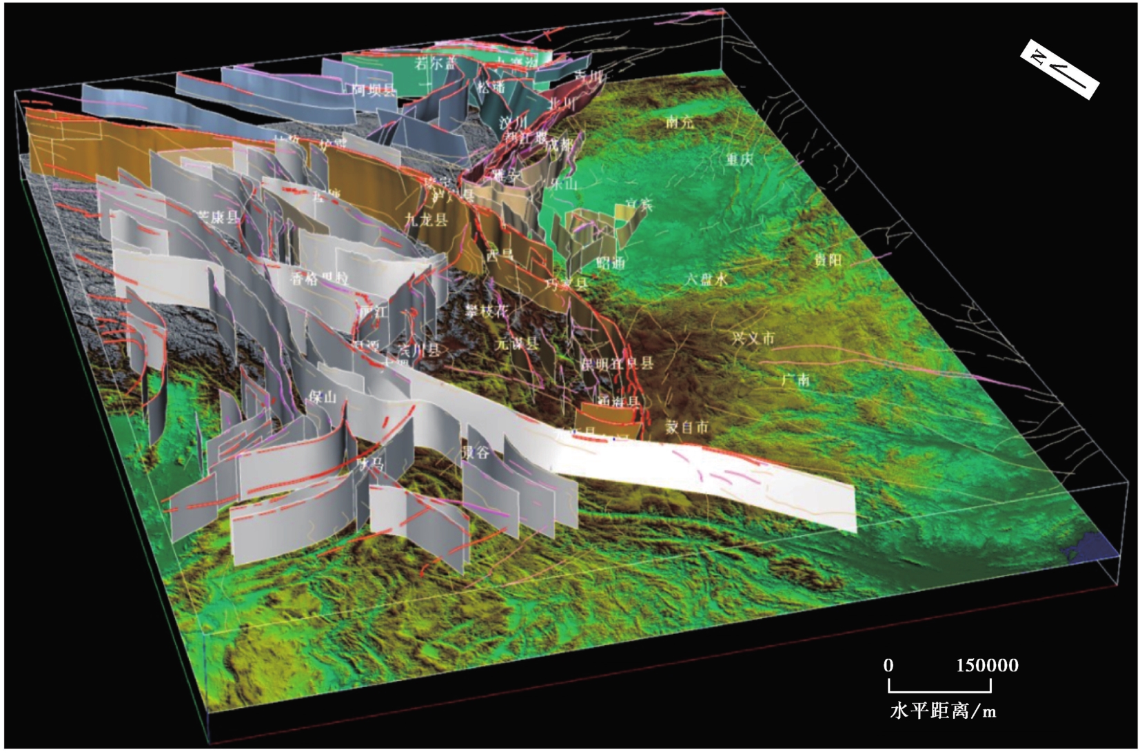
图1 川滇地区主要活动断裂三维模型V2.0+透视图(V︰H=2︰1)
Fig. 1 The perspective view of 3-D fault models version 2.0+ of Sichuan and Yunnan provinces(V︰H=2︰1).
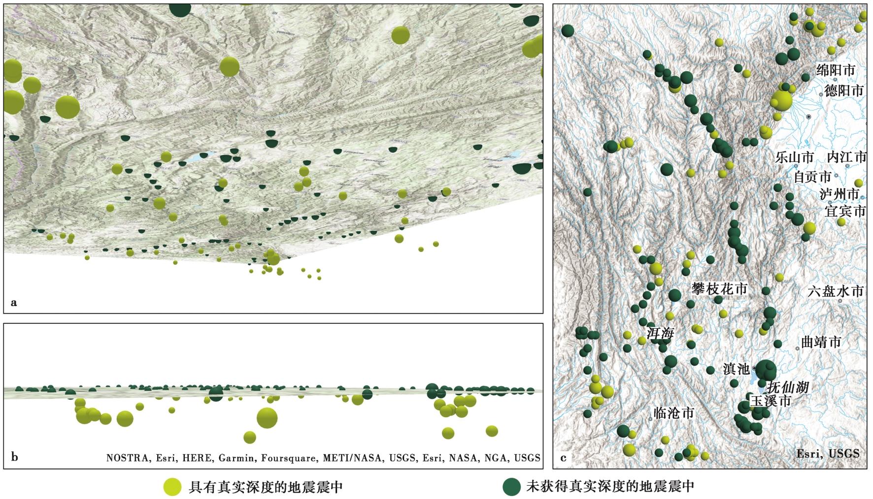
图2 强震目录空间分布图 a 在ArcGIS Pro中从地下向上仰视的角度; b 在ArcGIS Pro中的侧面视角; c 在ArcGIS Pro中的正射视角。强震目录分为已获取震源深度和不能获取震源深度2个子数据集
Fig. 2 Spatial distribution of strong earthquakes in study region.
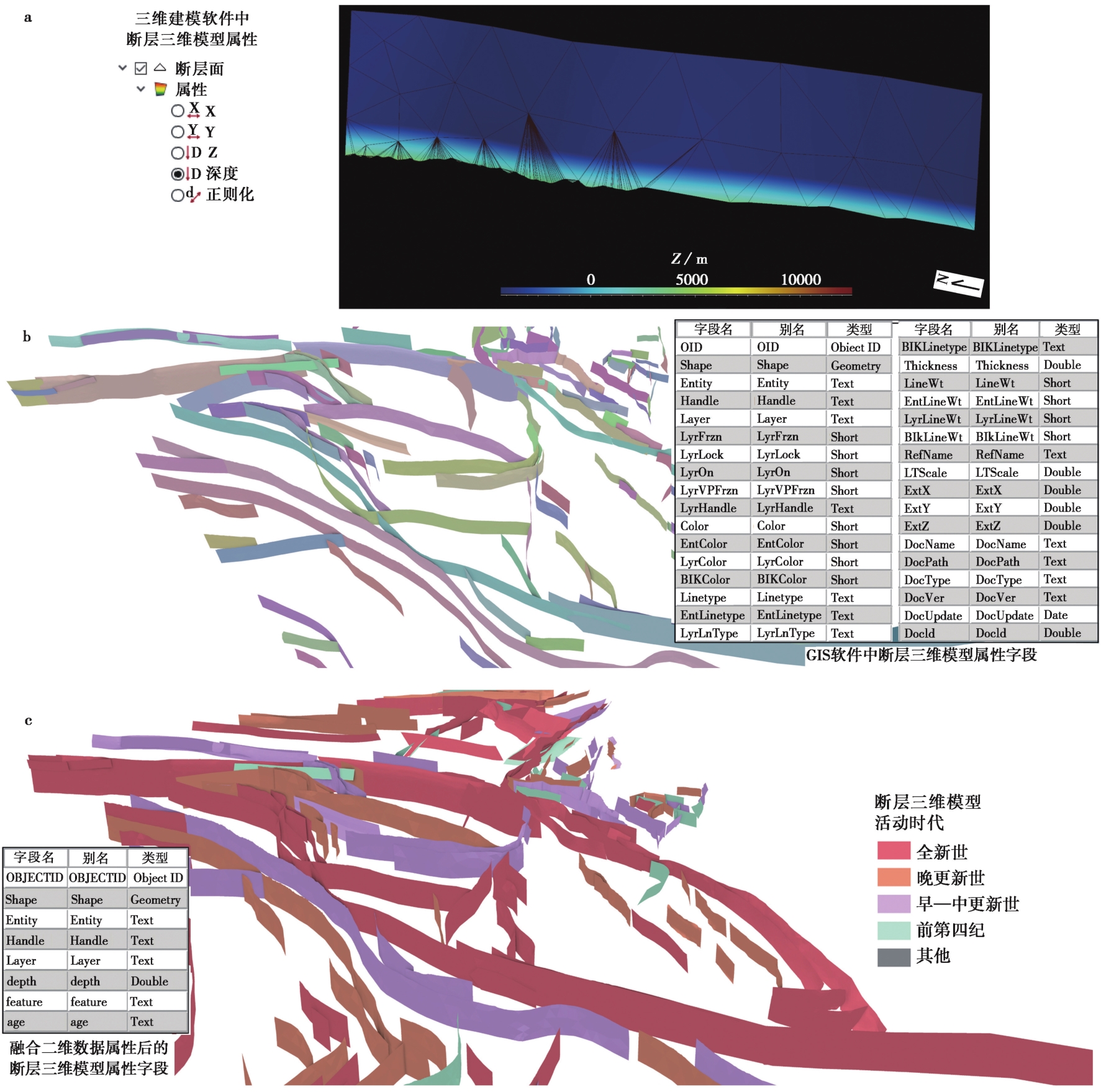
图3 数据迁移前后对比图 a SKUA-GOCAD软件中的断层三维模型及其属性; b 从SKUA-GOCAD软件直接转换后导入ArcGIS Pro 软件中的断层三维模型及其属性; c 完成融合后的断层三维模型及其属性。数据的质量和数据转换后的真实效果图
Fig. 3 Comparison diagram of before and after data migration.
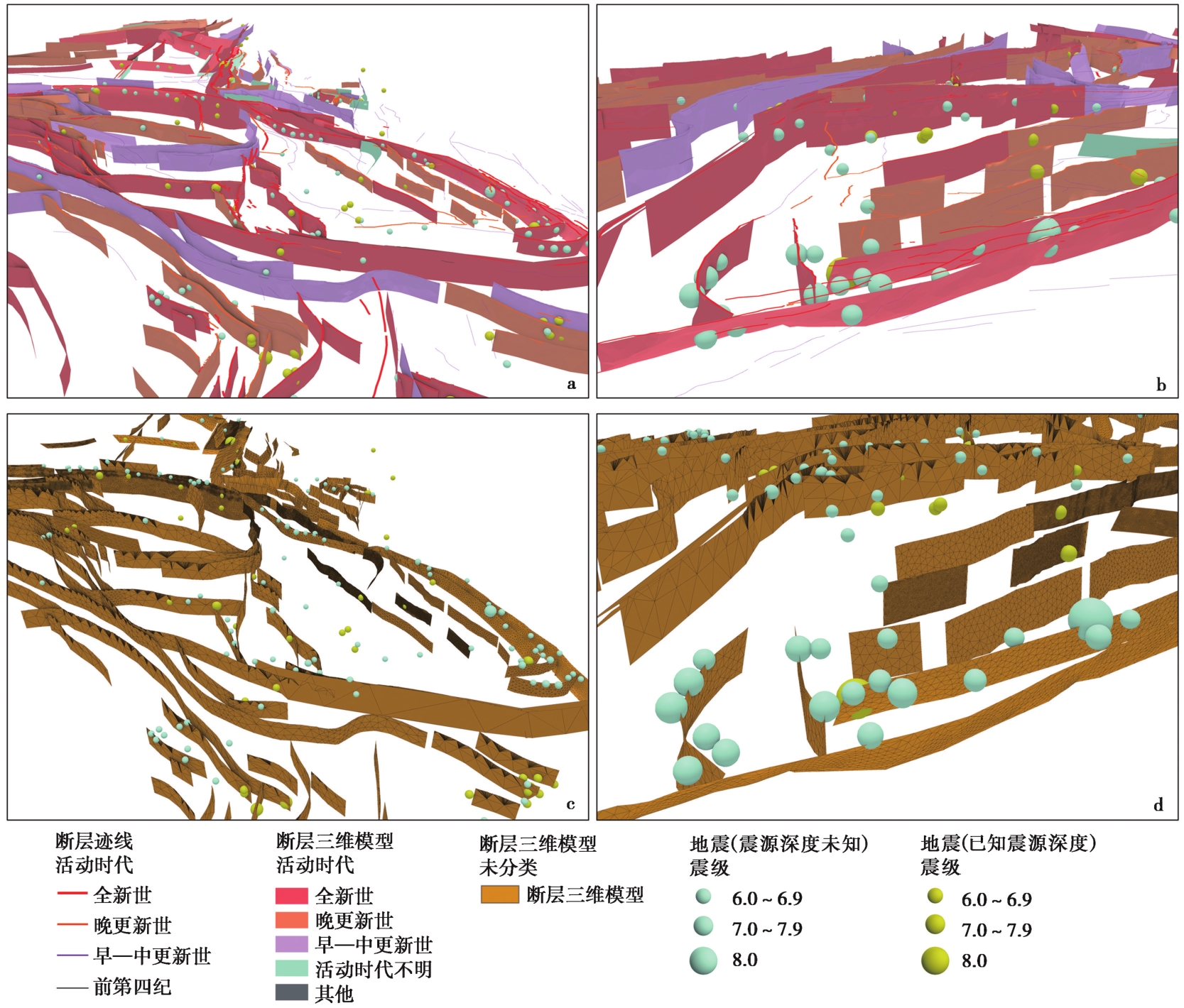
图4 数据融合前后的场景对比图 a、 b 融合后场景的2个视图; c、 d 融合前场景的2个视图
Fig. 4 Scene comparison before and after data fusion.
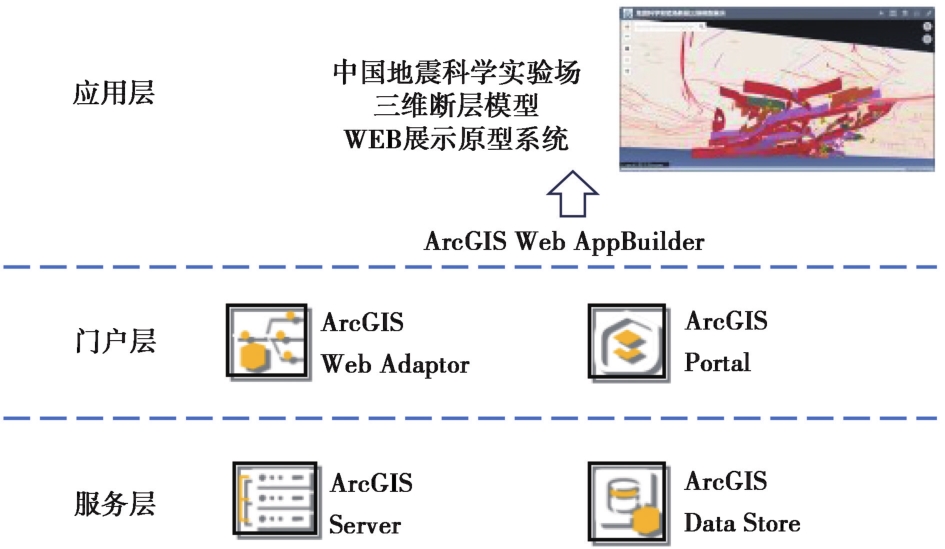
图5 中国地震科学实验场三维断层模型Web展示原型系统的架构图
Fig. 5 The architecture diagram of a web-based prototype system for the 3D fault models of the China Seismic Experimental Site.
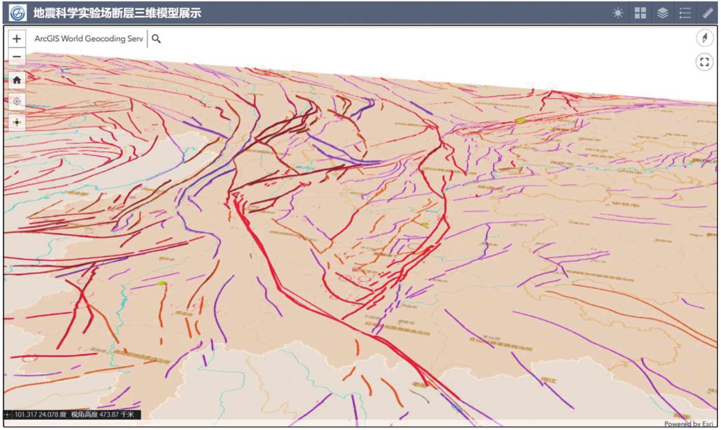
图6 中国地震科学实验场三维断层模型Web展示原型系统的地上视角
Fig. 6 The downward view from the sky of the web-based prototype system for the 3D fault models of the China Seismic Experimental Site.
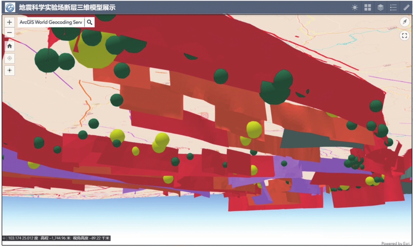
图7 地震科学实验场断层三维模型展示系统的地下视角
Fig. 7 The upward view from the ground of the web-based prototype system for the 3D fault models of the China Seismic Experimental Site.
| [1] |
陈桂华, 徐锡伟, 于贵华, 等. 2009. 2008年汶川 MS8.0 地震多断裂破裂的近地表同震滑移及滑移分解[J]. 地球物理学报, 52(5): 1384—1394.
|
|
|
|
| [2] |
邓起东, 张培震, 冉勇康, 等. 2003. 中国活动构造与地震活动[J]. 地学前缘, 10(S1): 66—73.
|
|
|
|
| [3] |
国家地震局. 1995. 中国历史强震目录(公元前23世纪—公元1911年)[Z]. 北京: 地震出版社.
|
|
State Seismological Bureau. 1995. The Historical Strong Earthquakes in China(23rd Century BC— 1911 AD)[Z]. Seismological Press, Beijing (in Chinese).
|
|
| [4] |
何付兵, 白凌燕, 王继明, 等. 2013. 夏垫断裂带深部构造特征与第四纪活动性讨论[J]. 地震地质, 35(3): 490—505. doi: 10.3969/j.issn.0253-4967.2013.03.004.
|
|
DOI |
|
| [5] |
徐锡伟. 2009. 5·12汶川8.0级地震地表破裂图集[CM]. 北京: 地震出版社.
|
|
|
|
| [6] |
徐锡伟, 韩竹军, 杨晓平, 等. 2016. 中国及邻近地区地震构造图[CM]. 北京: 地震出版社.
|
|
|
|
| [7] |
徐锡伟, 计凤桔, 于贵华, 等. 2000. 用钻孔地层剖面记录恢复古地震序列: 河北夏垫断裂古地震研究[J]. 地震地质, 22(1): 9—19.
|
|
|
|
| [8] |
徐锡伟, 江国焰, 于贵华, 等. 2014. 鲁甸6.5级地震发震断层判定及其构造属性讨论[J]. 地球物理学报, 57(9): 3060—3068.
DOI |
|
|
|
| [9] |
徐锡伟, 闻学泽, 叶建青, 等. 2008. 汶川 MS8.0 地震地表破裂带及其发震构造[J]. 地震地质, 30(3): 597—629.
|
|
|
|
| [10] |
许冲, 徐锡伟, 沈玲玲, 等. 2014. 2014年鲁甸 MS6.5 地震触发滑坡编录及其对一些地震参数的指示[J]. 地震地质, 36(4): 1186—1203. doi: 10.3969/j.issn.0253-4967.2014.04.020.
|
|
|
|
| [11] |
张国民, 汪素云, 李丽, 等. 2002. 中国大陆地震震源深度及其构造含义[J]. 科学通报, 47(9): 663—668.
|
|
|
|
| [12] |
张培震, 邓起东, 张竹琪, 等. 2013. 中国大陆的活动断裂、 地震灾害及其动力过程[J]. 中国科学(地球科学), 43(10): 1607—1620.
|
|
DOI URL |
|
| [13] |
中国地震局监测预报司. 2023. 中国 5 级以上地震目录汇编(1900年1月1日—2022年12月31日)[R]. 北京: 中国地震局监测预报司.
|
|
Earthquake Monitoring and Forecasting Department, China Earthquake Administration. 2023. A Compilation of Earthquakes with M≥5.0(Jan, 1, 1900—Dec, 31, 2022)[R]. Earthquake Monitoring and Forecasting Department, China Earthquake Administration, Beijing (in Chinese).
|
|
| [14] |
中国地震局震害防御司. 1999. 中国近代地震目录(公元1912—1990年, MS≥4.7)[Z]. 北京: 中国科学技术出版社.
|
|
Earthquake Disaster Prevention Department, China Earthquake Administration. 1999. The Modern Historical Earthquakes in China(1912—1990, MS≥4.7)[Z]. China Science and Technology Press, Beijing (in Chinese).
|
|
| [15] |
|
| [16] |
DOI URL |
| [17] |
DOI URL |
| [18] |
DOI URL |
| [19] |
DOI PMID |
| [20] |
DOI URL |
| [21] |
DOI PMID |
| [22] |
|
| [23] |
|
| [24] |
DOI URL |
| [25] |
|
| [1] | 黎益仕. 活动断层探测综合标准化[J]. 地震地质, 2023, 45(2): 455-463. |
| [2] | 杨晨艺, 李晓妮, 冯希杰, 黄引弟, 裴跟弟. 秦岭北缘断裂带的重要分支——桃川-户县断层的浅部结构与第四纪活动性[J]. 地震地质, 2023, 45(2): 464-483. |
| [3] | 张浩, 王金艳, 许汉刚, 李丽梅, 蒋新, 赵启光, 顾勤平. 安丘-莒县断裂新沂段的几何结构特征[J]. 地震地质, 2022, 44(6): 1448-1468. |
| [4] | 曹筠, 李彦宝, 冉勇康, 徐锡伟, 马董伟, 张志强. 城市隐伏活动断层避让典型案例分析--以新沂市郯庐断裂带沿线某场地为例[J]. 地震地质, 2022, 44(4): 1071-1085. |
| [5] | 杨晓平, 王萍, 李晓峰, 谢超, 周本刚, 黄雄南. 地形坡度和高程变异系数在识别墨脱活动断裂带中的应用[J]. 地震地质, 2019, 41(2): 419-435. |
| [6] | 鲁人齐, 徐锡伟, 陈立春, 陈桂华, 姚琪, 孙建宝, 任俊杰, 任治坤, 许冲, 魏占玉, 谭锡斌, 董绍鹏, 石峰, 吴熙彦. 2017年8月8日九寨沟MS7.0地震构造与震区三维断层初始模型[J]. 地震地质, 2018, 40(1): 1-11. |
| [7] | 吴熙彦, 徐锡伟, 于贵华, 程佳, 陈桂华, 安艳芬, 王启欣. 国家川滇实验场地震地表破裂带分布图编制[J]. 地震地质, 2018, 40(1): 27-41. |
| [8] | 蔡明刚, 鲁人齐, 何宏林, 徐锡伟, 王振南, 李海鸥, 吴熙彦. 水域三维地形与活动断层探测研究——以西昌邛海为例[J]. 地震地质, 2018, 40(1): 204-214. |
| [9] | 闫兵, 贾东. 沿走滑活动断层的基岩河道系统位错——以青藏高原东部为例[J]. 地震地质, 2017, 39(6): 1127-1142. |
| [10] | 邵延秀, 张波, 邹小波, 王爱国, 张帆宇, 袁道阳, 刘兴旺, 何文贵. 采用无人机载LiDAR进行快速地质调查实践[J]. 地震地质, 2017, 39(6): 1185-1197. |
| [11] | 郝海健, 何宏林, 魏占玉, 石峰. 同震地表破裂及活动断层迹线的几何形貌特征[J]. 地震地质, 2017, 39(6): 1267-1282. |
| [12] | 徐锡伟, 郭婷婷, 刘少卓, 于贵华, 陈桂华, 吴熙彦. 活动断层避让相关问题的讨论[J]. 地震地质, 2016, 38(3): 477-502. |
| [13] | 李胜强, 张玲, 杨晓平, 黄伟亮, 黄雄南, 杨海波. 库车坳陷东部秋里塔格背斜带的活动断层及其形成机制[J]. 地震地质, 2016, 38(2): 223-239. |
| [14] | 吴熙彦, 于贵华, 杜克平, 徐锡伟. 活动断层探察的快速制图技术研究[J]. 地震地质, 2016, 38(2): 397-409. |
| [15] | 隋远, 杜克平, 于贵华, 徐锡伟, 吴熙彦, 甘德强. 全国活动断层数据集成与共享平台设计与建设——以华北构造区活动断层探测和调查基础数据库信息共享平台为例[J]. 地震地质, 2015, 37(4): 1115-1124. |
| 阅读次数 | ||||||
|
全文 |
|
|||||
|
摘要 |
|
|||||
