地震地质 ›› 2026, Vol. 48 ›› Issue (5): 1253-1266.DOI: 10.3969/j.issn.0253-4967.20260038
曹筠1),2)( ), 刘书峰1),2),3), 高晨1),2), 李彦宝3), 陈杨4)
收稿日期:2026-03-16
修回日期:2026-05-13
出版日期:2026-11-11
发布日期:2026-11-11
作者简介:曹筠, 男, 1982年生, 博士, 正高级工程师, 主要从事活动构造与地震研究, E-mail: cjconan82@163.com。
基金资助:
CAO Jun1),2)(), LIU Shu-feng1),2),3), GAO Chen1),2), LI Yan-bao3), CHEN Yang4)
Received:2026-03-16
Revised:2026-05-13
Online:2026-11-11
Published:2026-11-11
摘要:
山西地堑系的北部尾端在区域拉张应力作用下形成了盆岭构造格架, 即晋冀蒙盆岭构造区。晋冀蒙盆岭构造区内NE走向的全新世活动断层为区域主要历史强震的发震构造。20世纪80年代末-90年代初, 晋冀蒙盆岭构造区内的阳原盆地西侧发生2次重要的中强震群, 阳原盆地东侧的震情形势陡变, 而盆地东侧控盆的大型活动断层为阳原盆地北缘断裂。以往在阳原盆地北缘断裂上仅发现晚更新世的断层活动现象, 而晋冀蒙盆岭构造区内其他NE走向的控盆断层均为全新世活动断层。在区域统一构造应力场的作用下, 基于大型走滑断裂带尾端的马尾辫状构造模型, 如何解释位于盆岭构造区中部的阳原盆地北缘断裂为晚更新世活动断层的现象可能需要进一步求证。因此, 文中基于遥感解译和野外地质地貌调查结果, 厘定了阳原盆地北缘断裂的地表精细几何结构。通过分析典型断错地层剖面和年代学样品结果, 获得阳原盆地北缘断裂东、中段为全新世活动断层, 西段晚第四纪以来没有断层运动的结论。进一步综合分析阳原盆地南、北缘控盆断裂的全新世活动断层的范围后发现, 全新世时期控盆断层在盆地南、北缘之间相互调整, 存在接续向E发育的过程, 因此更应该重视盆地东侧阳原盆地北缘断裂未来发生大地震的危险性。
曹筠, 刘书峰, 高晨, 李彦宝, 陈杨. 阳原盆地北缘断裂全新世活动证据及其构造意义[J]. 地震地质, 2026, 48(5): 1253-1266.
CAO Jun, LIU Shu-feng, GAO Chen, LI Yan-bao, CHEN Yang. EVIDENCES OF THE HOLOCENE ACTIVITY OF NORTHERN MARGIN FAULT OF THE YANGYUAN BASIN AND ITS IMPLICATIONS[J]. SEISMOLOGY AND GEOLOGY, 2026, 48(5): 1253-1266.
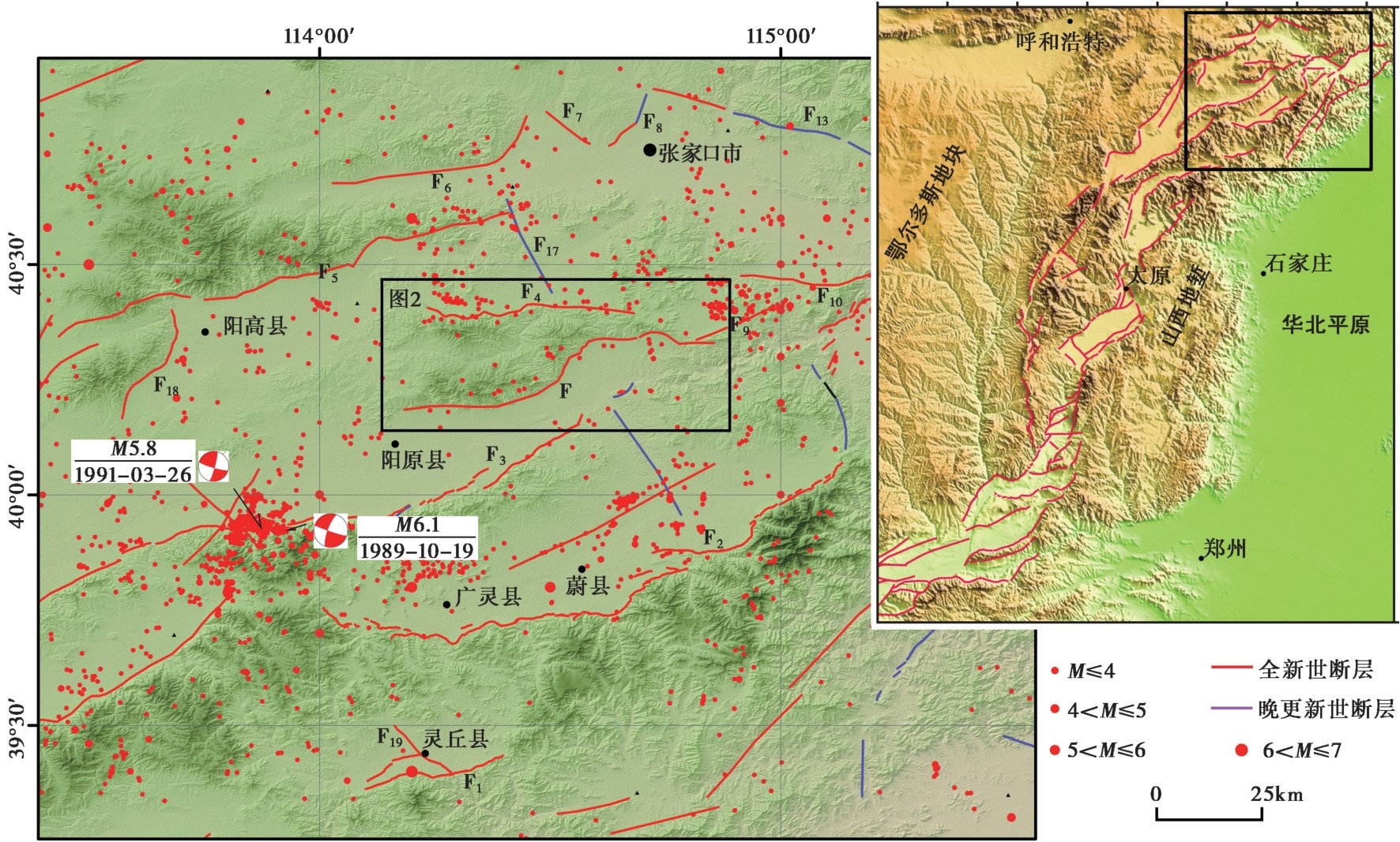
图1 晋冀蒙盆岭构造区的地震构造图 F阳原盆地北缘断裂; F1太白维山山前断裂; F2蔚广盆地南缘断裂; F3六棱山北麓断裂; F4怀安盆地南缘断裂; F6怀安盆地北缘断裂; F7万全盆地北缘断裂; F8洗马林断裂; F9深井盆地南缘断裂
Fig. 1 Seismotectonic map of the basin-range structure region in Shanxi-Hebei-Inner Mongolia.
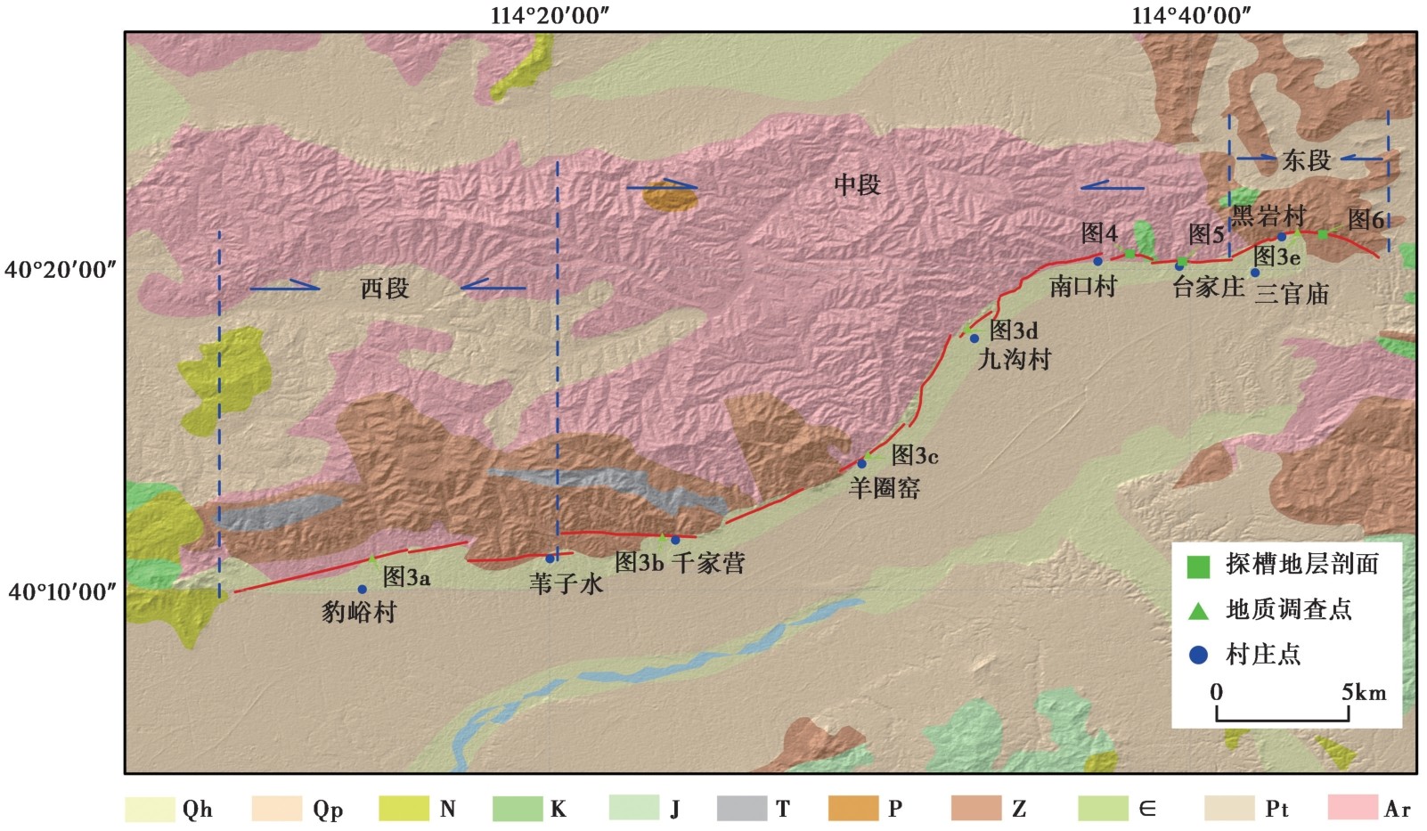
图2 阳原盆地北缘断裂地表断层的精细几何结构和断层沿线地质调查点分布图
Fig. 2 Distribution map of surface geometry and geological survey sites along the Northern margin fault of the Yangyuan Basin.
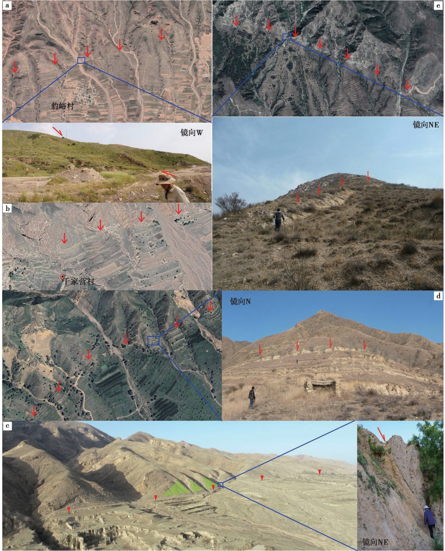
图3 阳原盆地北缘断裂沿线的典型地形地貌和断层剖面
Fig. 3 Typical landforms and fault profiles along the Northern margin fault of the Yangyuan Basin.
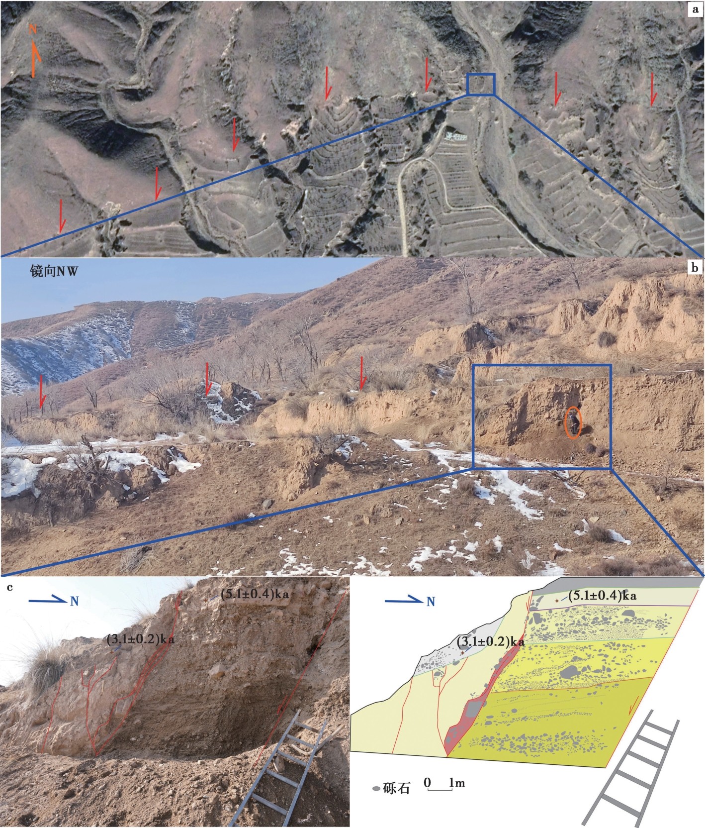
图4 南口村东的地层剖面位置及解释图 图c右图中各分层的描述如下: 层1, 小砾石水平层理, 局部偶见大砾石; 层2, 以小砾石水平层理为主, 局部偶见大砾石层; 层3, 大砾石水平层理层, 砾石磨圆度较差; 层4, 黄土含大砾石层; 层5, 马兰黄土层, 黄土局部受影响呈块状; 层6,坡积黄土, 松散, 底部成块状, 顶部为人工改造土; 层7, 人工改造耕作土
Fig. 4 Location and interpretation of stratigraphic section near east of Nankou village.
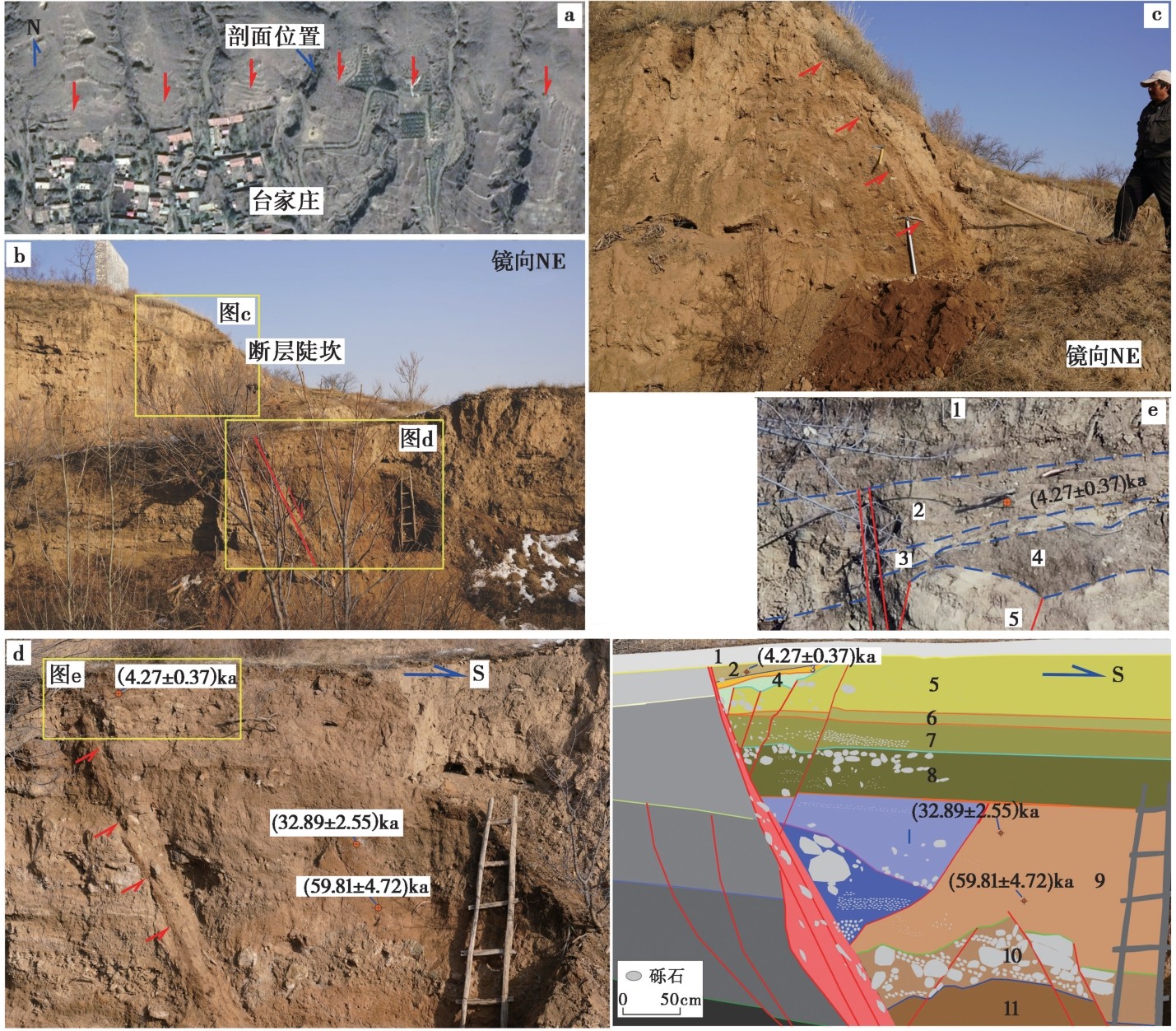
图5 台家庄村后的地层剖面位置及地层剖面 图d右图中各分层的描述如下: 层1, 地表人工改造耕作土; 层2, 深棕黄色砂质黏土, 含有小砾石层; 层3, 浅黄色硬质黏土层, 薄层, 厚度向主断层部位逐渐变薄; 层4, 深棕褐色黏土层, 质硬, 含有小砾石; 层5, 浅黄色黏土层, 质硬, 偶见大砾石, 含有小砾石, 砾石磨圆度一般; 层6, 深灰棕色薄黏土层, 含有一定砂质, 在断层带附近相对较薄, 远离断层附近该层逐渐增厚; 层7, 青黄色黏土含有小砾石层; 层8, 青棕色黏土层, 含有砾石, 顶部有局部形成大砾石团块; 层9, 黄棕色黏土砂层, 含有小砾石; 层10, 大砾石层, 砾石直径较大, 很多超过10cm, 棱角明显; 层11, 黄棕色砾石砂层, 具有一定的黏土含量
Fig. 5 Location and stratigraphic section near Taijiazhuang village.
| 野外编号 | 样品描述 | 埋深 /m | 测量方法 | 等效剂量 /Gy | 环境剂量率 /Gy·ka-1 | 年龄 /ka |
|---|---|---|---|---|---|---|
| NK-OSL-03 | 冲洪积黄土 | 0.26 | 细颗粒石英 | 13.21±0.45 | 4.2±0.3 | 3.1±0.2 |
| NK-OSL-04 | 沉积黄土 | 0.50 | 细颗粒石英 | 20.2±0.7 | 4.0±0.2 | 5.1±0.4 |
| DZ-OSL-03 | 冲洪积黄土 | 2.31 | 细颗粒石英 | 219.7±5.77 | 3.67±0.27 | 59.81±4.72 |
| DZ-OSL-05 | 冲洪积黄土 | 1.70 | 粗颗粒石英 | 79.85±4.81 | 2.40±0.10 | 32.89±2.55 |
| DZ-OSL-18 | 冲洪积黄土 | 0.25 | 细颗粒石英 | 13.45±0.62 | 3.15±0.23 | 4.27±0.37 |
表1 南口村和台家庄村剖面光释光(OSL)样品测年结果
Table1 OSL Dating result of samples from the Nankoucun and Taijiazhuangcun sections
| 野外编号 | 样品描述 | 埋深 /m | 测量方法 | 等效剂量 /Gy | 环境剂量率 /Gy·ka-1 | 年龄 /ka |
|---|---|---|---|---|---|---|
| NK-OSL-03 | 冲洪积黄土 | 0.26 | 细颗粒石英 | 13.21±0.45 | 4.2±0.3 | 3.1±0.2 |
| NK-OSL-04 | 沉积黄土 | 0.50 | 细颗粒石英 | 20.2±0.7 | 4.0±0.2 | 5.1±0.4 |
| DZ-OSL-03 | 冲洪积黄土 | 2.31 | 细颗粒石英 | 219.7±5.77 | 3.67±0.27 | 59.81±4.72 |
| DZ-OSL-05 | 冲洪积黄土 | 1.70 | 粗颗粒石英 | 79.85±4.81 | 2.40±0.10 | 32.89±2.55 |
| DZ-OSL-18 | 冲洪积黄土 | 0.25 | 细颗粒石英 | 13.45±0.62 | 3.15±0.23 | 4.27±0.37 |
| 野外编号 | 样品描述 | 埋深/m | 距今年龄/a BP | Oxcal校正年龄(μ+σ)/a BP |
|---|---|---|---|---|
| YYB01# | 有机质沉积物 | 0.52 | 2340±30 | 2350±45 |
| YYB02# | 有机质沉积物 | 0.52 | 2130±30 | 2100±75 |
表2 阳原盆地东段地层剖面14C样品测年结果
Table2 14C dating results of samples from east section of the Yangyuan Basin
| 野外编号 | 样品描述 | 埋深/m | 距今年龄/a BP | Oxcal校正年龄(μ+σ)/a BP |
|---|---|---|---|---|
| YYB01# | 有机质沉积物 | 0.52 | 2340±30 | 2350±45 |
| YYB02# | 有机质沉积物 | 0.52 | 2130±30 | 2100±75 |
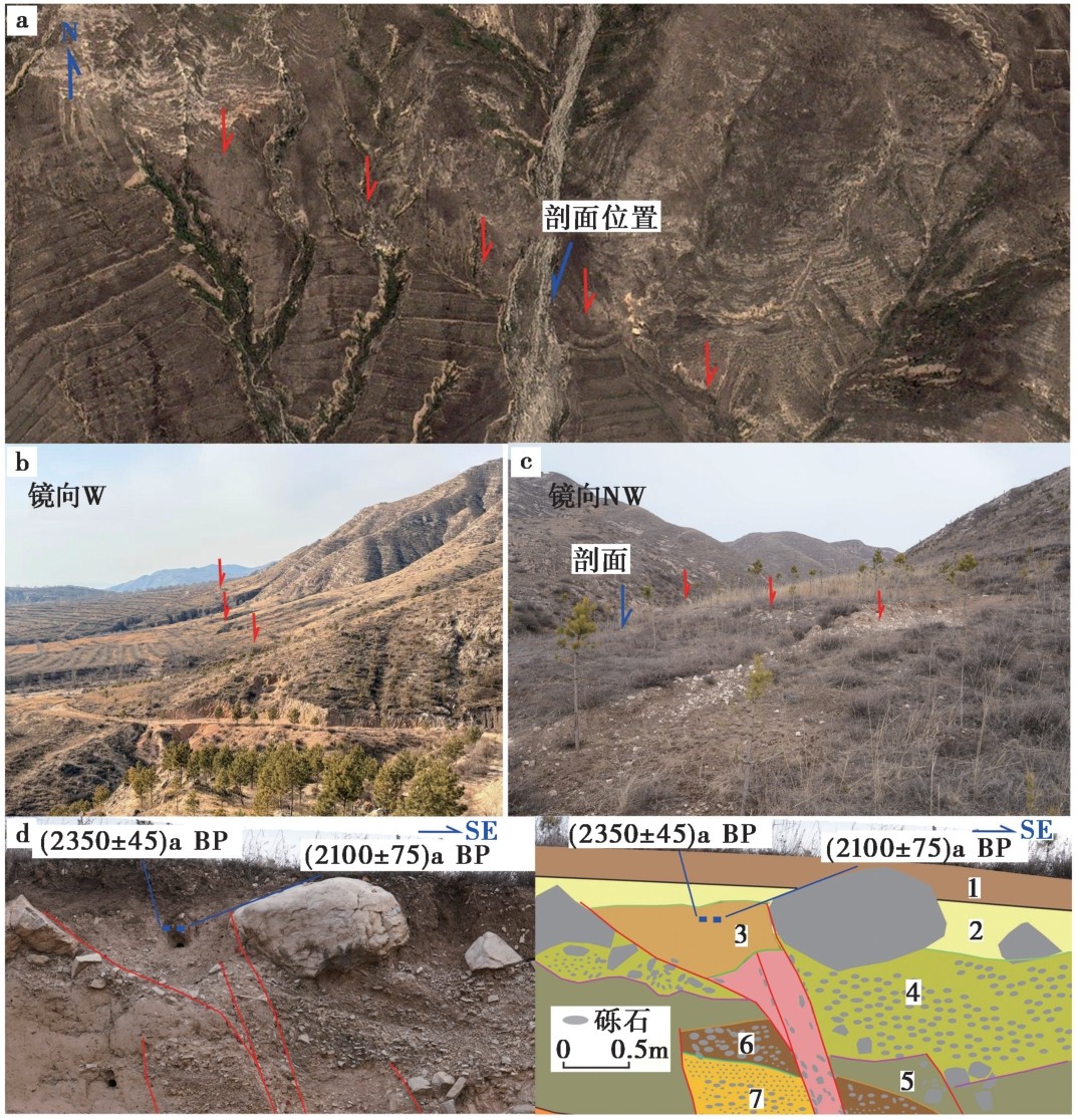
图6 阳原盆地北缘断裂东段的地层剖面位置及地层剖面 图d右图中各小分层的描述如下: 层1, 人工改造耕作土; 层2, 灰黑色, 黑色黏土, 含有磨圆小砾石; 层3, 黄土楔, 偶见砾石; 层4, 洪积砾石, 顶部有大砾石, 且大砾石棱角分明; 层5, 棕色黄土层, 断层附近有小砾石; 层6, 大砾石呈水平状,偶见小砾石; 层7, 大砾石和小砾石互层堆积
Fig. 6 Location and stratigraphic section in the eastern segment of the Northern margin fault of the Yangyuan Basin.
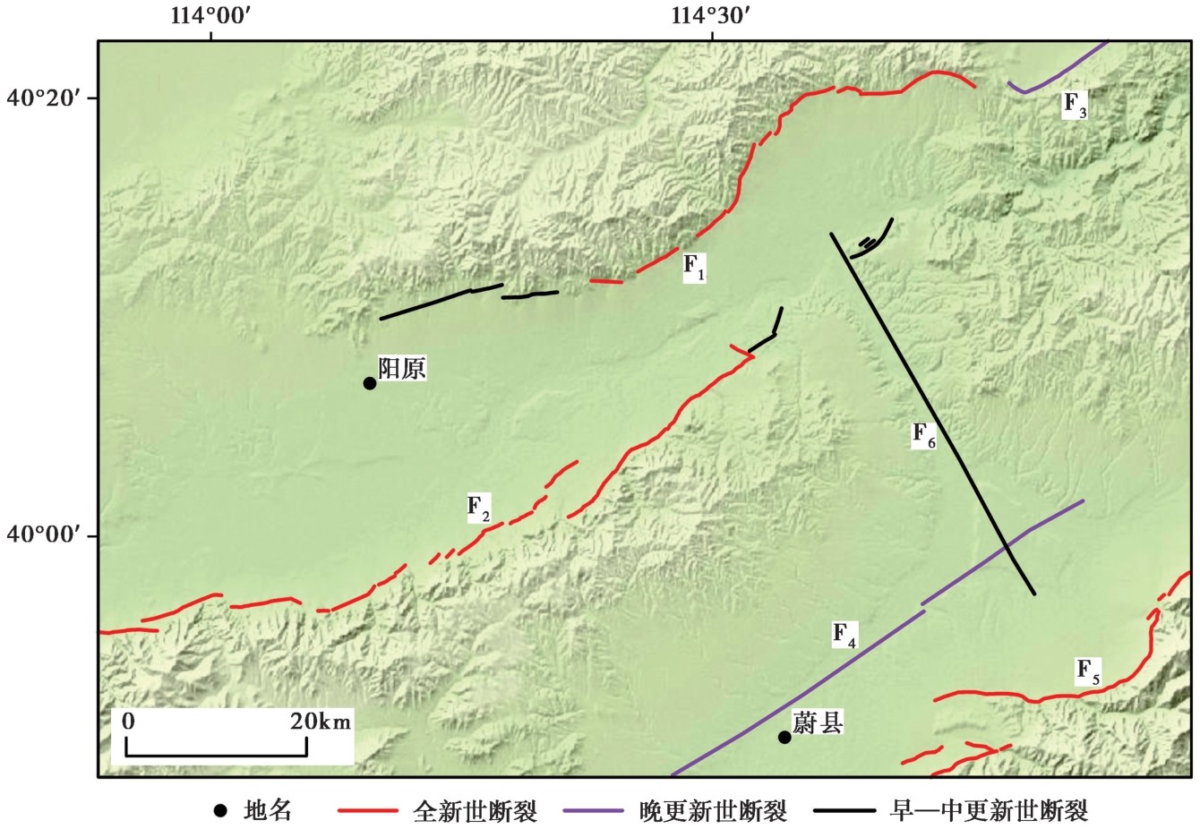
图7 阳原盆地南北缘控盆断裂活动断层分布图 F1阳原盆地北缘断裂; F2六棱山北麓断裂; F3深井盆地南缘断裂; F4壶流河断裂; F5蔚广盆地南缘断裂
Fig. 7 Active fault distribution of basin-controlling faults at north and south margins of the Yangyuan Basin.
| [1] |
陈绍绪, 张跃刚, 乔子云, 等. 2003. 晋冀蒙交界地区主要断裂的现今活动[J]. 华北地震科学, 21(2): 16-22.
|
|
|
|
| [2] |
程绍平, 方仲景, 杨桂枝, 等. 1995. 论延庆盆地北缘断裂带的分段与地震预测[J]. 地震地质, 17(3): 231-240.
|
|
|
|
| [3] |
崔笃信, 郝明, 李煜航, 等. 2016. 鄂尔多斯块体周缘地区现今地壳水平运动与应变[J]. 地球物理学报, 59(10): 3646-3661.
DOI |
|
|
|
| [4] |
邓起东. 1984. 中国几条活动断裂的运动机制、滑动速率和地震重复性的研究概述[J]. 国际地震动态, (3): 5-8.
|
|
|
|
| [5] |
邓起东, 张培震, 冉勇康, 等. 2002. 中国活动构造基本特征[J]. 中国科学(D辑), 32(12): 1020-1030.
|
|
|
|
| [6] |
段瑞涛. 1994. 阳原盆地及邻近地区活动断裂与地震危险性研究[D]. 北京: 国家地震局地质研究所.
|
|
|
|
| [7] |
段瑞涛, 方仲景, 郑炳华. 1995. 河北省阳原盆地北缘断裂第四纪活动特征[G]//中国地震局地质研究所. 活动断裂研究(4). 北京: 地震出版社: 184-192.
|
|
|
|
| [8] |
高晨, 曹筠, 刘书峰, 等. 2021. 基于GPS和SBAS-InSAR的阳原盆地北缘断裂现今地表形变特征[J]. 大地测量与地球动力学, 41(12): 1288-1293.
|
|
|
|
| [9] |
罗全星, 李有利, 胡秀, 等. 2022. 山西地堑系北部六棱山北麓断裂西段晚第四纪右旋走滑速率的约束[J]. 第四纪研究, 42(3): 717-731.
|
|
|
|
| [10] |
马兴全, 李彦宝, 冉勇康, 等. 2013. 灵丘盆地主要活动断裂和1626灵丘地震发震构造[J]. 地震地质, 35(2): 208-221. doi: 10.3969/j.issn.0253-4967.2013.02.002.
|
|
DOI |
|
| [11] |
M7专项工作组. 2012. 中国大陆大地震中-长期危险性研究[M]. 北京: 地震出版社.
|
|
Work Group of M7. 2012. Study on the Mid-to Long-term Potential of Large Earthquakes on the Chinese Continent[M]. Seismological Press, Beijing (in Chinese).
|
|
| [12] |
冉勇康. 2000. 首都圈山区活动构造定量资料与强震预测对应差异的思考[C]. 中国地震学会. 中国地震学会第8次学术大会论文摘要集. 北京: 地震出版社: 107.
|
|
|
|
| [13] |
冉勇康, 陈立春, 徐锡伟. 2001. 北京西北活动构造定量资料与未来强震地点的讨论[J]. 地震学报, 23(5): 502-513.
|
|
|
|
| [14] |
冉勇康, 方仲景, 李志义, 等. 1992. 河北怀来-涿鹿盆地北缘活断层的古地震事件与断层分段[J]. 中国地震, 8(3): 76-87.
|
|
|
|
| [15] |
孙稳. 2018. 六棱山北麓断裂晚第四纪活动性[D]. 北京: 中国地震局地质研究所.
|
|
|
|
| [16] |
田勤俭, 王林, 李德文, 等. 2012. 蔚广盆地南缘断裂1︰5万条带状地质填图[CM]. 北京: 中国地震局地震预测研究所.
|
|
|
|
| [17] |
王鸣, 张廉强, 王培德. 1994. 1991年山西省大同-阳高MS5.8地震的断层面[J]. 地震学报, 16(1): 124-128.
|
|
DOI URL |
|
| [18] |
韦宝珠, 王凯, 姚振兴. 1992. 1989年大同-阳高地震震源机制及发震模式研究[J]. 中国地震, 8(1): 51-59.
|
|
|
|
| [19] |
徐锡伟, 车用太, 杨主恩, 等. 1991. 大同-阳高地震群发震构造模式的讨论[J]. 中国地震, 7(2): 79-87.
|
|
|
|
| [20] |
徐锡伟, 米仓伸之, 铃木康弘, 等. 1996. 山西六棱山北麓晚第四纪不规则断裂作用的地貌学研究[J]. 地震地质, 18(2): 169-181.
|
|
|
|
| [21] |
徐锡伟, 吴卫民, 张先康, 等. 2002. 首都圈地区地壳最新构造变动与地震[M]. 北京: 科学出版社.
|
|
|
|
| [22] |
徐锡伟, 吴熙彦, 于贵华, 等. 2017. 中国大陆高震级地震危险区判定的地震地质学标志及其应用[J]. 地震地质, 39(2): 219-275.
DOI |
|
DOI |
|
| [23] |
张红艳, 谢富仁, 荆振杰. 2009. 京西北盆岭构造区现代构造应力场的非均匀特征[J]. 地球物理学报, 52(12): 3061-3071.
|
|
|
|
| [24] |
张培震, 邓起东, 张国民, 等. 2003. 中国大陆的强震活动与活动地块[J]. 中国科学(D辑), 33(S1): 12-20.
|
|
|
|
| [25] |
|
| [26] |
|
| [27] |
DOI URL |
| [28] |
DOI URL |
| [29] |
DOI URL |
| [1] | 罗全星, 李传友, 任光雪, 李新男, 马字发, 董金元. 阳高-天镇断裂晚第四纪活动特征及滑动速率[J]. 地震地质, 2020, 42(2): 399-413. |
| 阅读次数 | ||||||
|
全文 |
|
|||||
|
摘要 |
|
|||||