地震地质 ›› 2022, Vol. 44 ›› Issue (2): 461-483.DOI: 10.3969/j.issn.0253-4967.2022.02.012
• 2021年玛多地震地表破裂机理研究专题文章 • 上一篇 下一篇
刘小利1,5)( ), 夏涛1), 刘静2,4),*(), 姚文倩2), 徐晶3), 邓德贝尔1), 韩龙飞2), 贾治革1), 邵延秀2), 王焱2), 乐子扬5), 高天琪5)
收稿日期:2022-01-02
修回日期:2022-03-18
出版日期:2022-04-20
发布日期:2022-06-14
通讯作者:
刘静
作者简介:刘小利, 女, 1977年生, 2008年于武汉大学获摄影测量与遥感专业博士学位, 副研究员, 研究方向为遥感减灾应用、 构造地貌学, E-mail: liuxl_j@163.com。
基金资助:
LIU Xiao-li1,5)(), XIA Tao1), LIU-ZENG Jing2,4),*(), YAO Wen-qian2), XU Jing3), DENG De-bei-er1), HAN Long-fei2), JIA Zhi-ge1), SHAO Yan-xiu2), WANG Yan2), YUE Zi-yang5), GAO Tian-qi5)
Received:2022-01-02
Revised:2022-03-18
Online:2022-04-20
Published:2022-06-14
Contact:
LIU-ZENG Jing
摘要:
地震地表破裂是理解大陆地壳变形模式和地震破裂行为的关键, 也是活动断层避让带设置的直接依据。2021年5月22日青海玛多 MW7.4 地震沿昆仑山口-江错断裂江错段形成了长达158km的同震地表破裂, 造成沿线野马滩大桥、 昌马河大桥坍塌。文中基于震后2次大范围现场调查资料和震区3~7cm分辨率的无人机航片, 获得了本次地震详细的地表破裂, 在精细填图的基础上, 阐述了玛多地震地表破裂、 地表裂缝、 砂土液化带和带状塌陷等多种类型裂缝的分布特征及其意义。除在断裂相交处存在多条次级破裂外, 局部存在大量延伸长、 走向稳定、 具有雁列特征的裂缝带, 最远处与主破裂带的距离>5km; 在震中附近及震中以西、 以东多个段落跨断层数千米范围内存在分支破裂、 斜列式地表裂缝、 砂土液化带、 带状塌陷和地裂缝等与同震变形相关的地表特征。玛多地震分布式同震地表裂缝的揭示, 主要得益于大范围、 密集的现场调查和厘米级高分辨率航片的精细解译, 使小位移量破裂或微弱裂缝得到充分识别。由于缺乏明确的位错标志, 难以甄别未在主破裂断层上的同震地表裂缝是构造成因还是震动成因, 分析其空间分布形态、 余震分布及其震源机制、 区域构造背景等, 经初步推测, 不排除有些裂缝代表区域先存断层的继承性活动与次级断层触发活动的可能性。对分布式同震地表裂缝的精细刻画有助于全面理解地震破裂过程的机理, 对于重要工程抗震减灾的有效设防具有现实意义。
中图分类号:
刘小利, 夏涛, 刘静, 姚文倩, 徐晶, 邓德贝尔, 韩龙飞, 贾治革, 邵延秀, 王焱, 乐子扬, 高天琪. 2021年青海玛多MW7.4地震分布式同震地表裂缝特征[J]. 地震地质, 2022, 44(2): 461-483.
LIU Xiao-li, XIA Tao, LIU-ZENG Jing, YAO Wen-qian, XU Jing, DENG De-bei-er, HAN Long-fei, JIA Zhi-ge, SHAO Yan-xiu, WANG Yan, YUE Zi-yang, GAO Tian-qi. DISTRIBUTED CHARACTERISTICS OF THE SURFACE DEFORMATIONS ASSOCIATED WITH THE 2021 MW7.4 MADOI EARTHQUAKE, QINGHAI, CHINA[J]. SEISMOLOGY AND GEOLOGY, 2022, 44(2): 461-483.
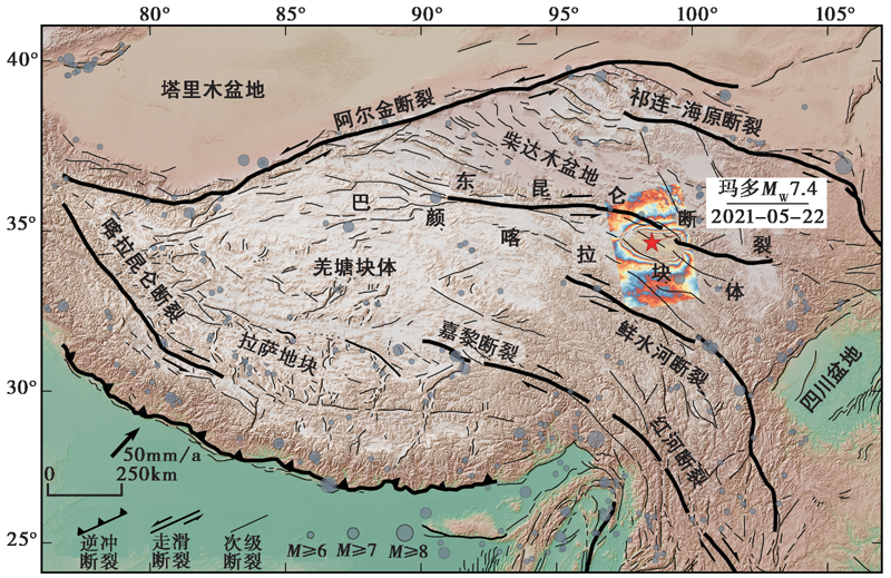
图 1 青藏高原的主要活动断裂及强震分布图 活动断裂修改自Tapponnier等(2001), 五角星指示2021年5月22日 MW7.4 玛多强震, 干涉图基于2021年5月20日与26日的Sentinel-1 C-band SAR降轨数据获得
Fig. 1 Distribution of major active faults and earthquakes of the Tibetan plateau.
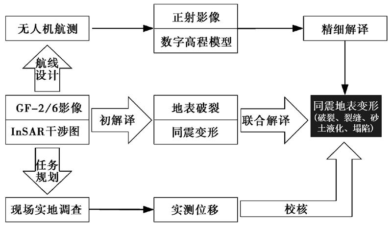
图 2 同震地表变形数据的采集与处理
Fig. 2 Data collection and processing process for seismic surface deformation.
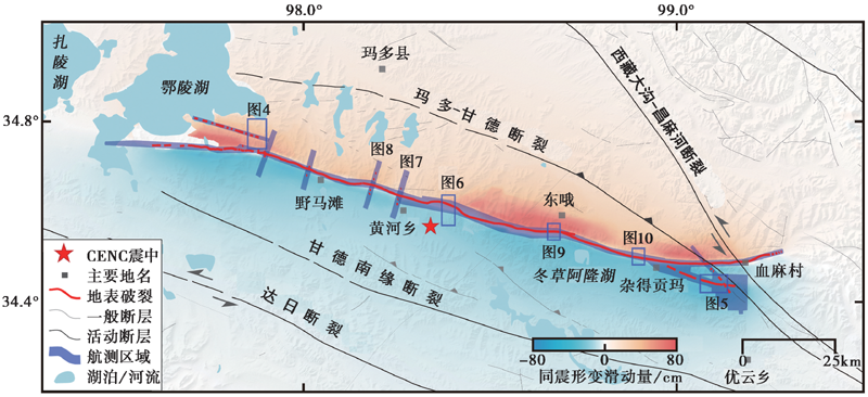
图 3 无人机摄影测量作业区的示意图 一般断层修改自1︰25万地质图, 活动断层修改自全国活动断层数据库(2006版), 背景为30m DEM叠加降轨InSAR同震形变场
Fig. 3 Sketch map of Madoi UAV photogrammetric area.
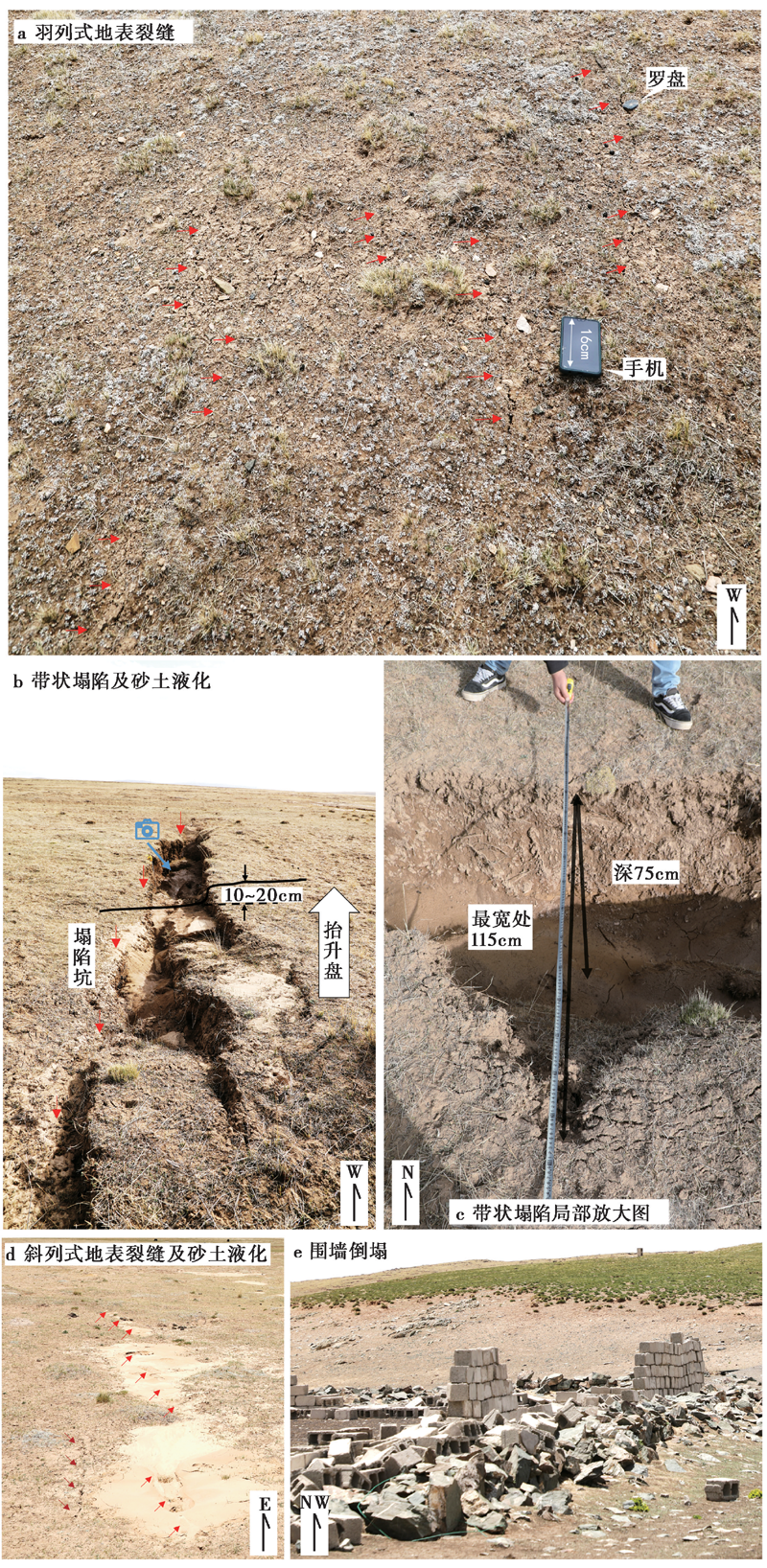
图 4 鄂陵湖湖滨区的同震地表变形 a 近EW向右阶羽状裂缝; b 串珠状砂土液化伴随的条带状塌陷坑, 显示北侧被垂向抬升10~20cm; c 图b中相机拍摄的塌陷坑的局部放大图; d 近EW向裂缝及右阶斜列串珠状砂土液化; e 围墙倒塌
Fig. 4 Coseismic surface deformation near the lakesides of the Eling Lake.
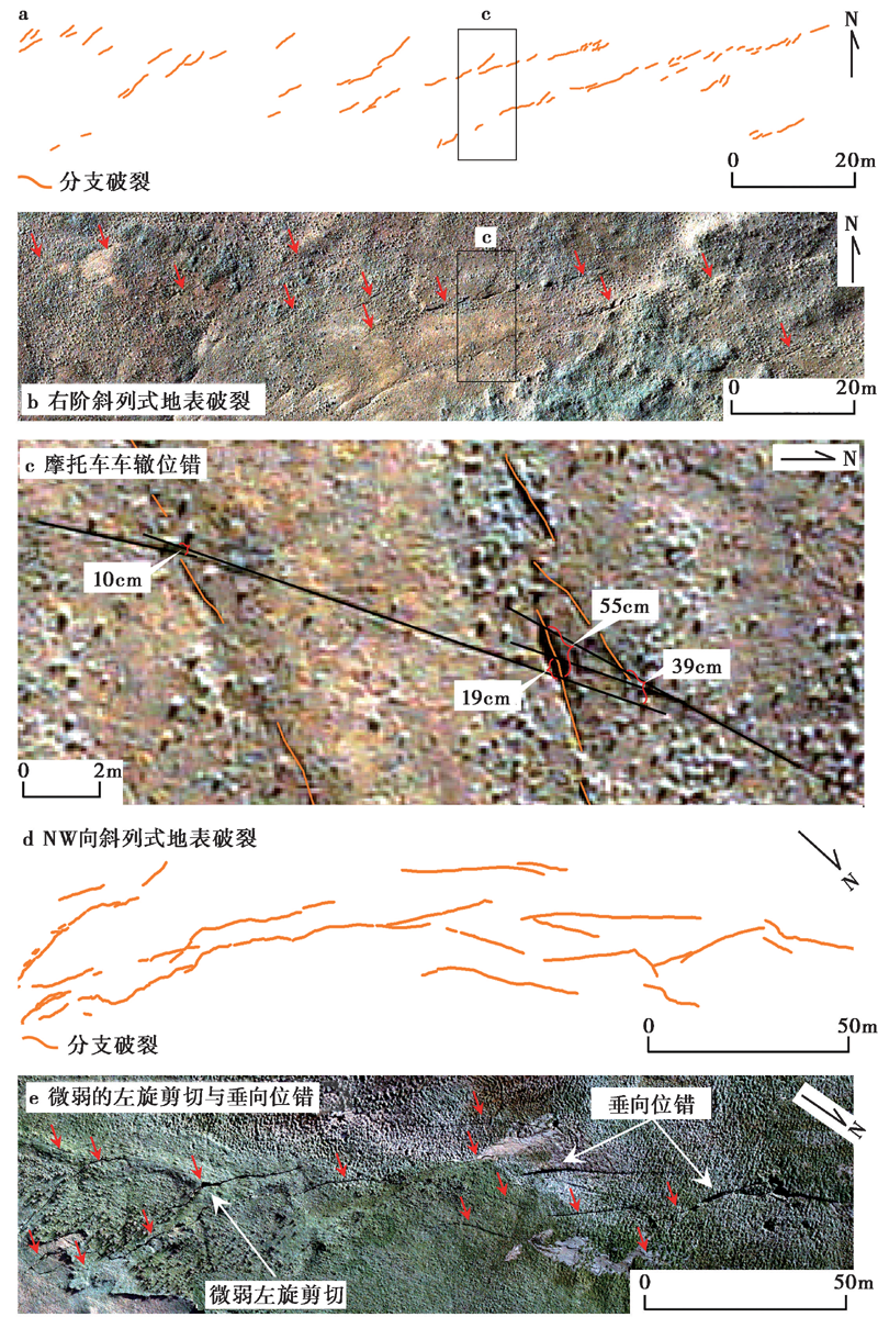
图 5 优云乡一带的同震地表破裂 a、 b 近EW向右阶斜列破裂; c 图a、 b的局部放大, 显示车辙发生左旋位错, 北侧的位错量为19~55cm, 南侧的位错量为10cm; d、 e NW向破裂, 显示微弱的左旋位错和南盘抬升
Fig. 5 Coseismic surface ruptures near the Youyun Township.
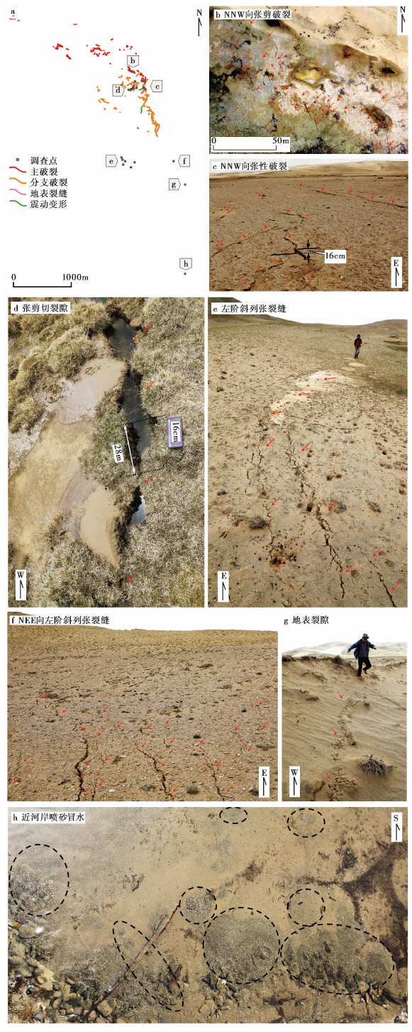
图 6 震中以东3~5km处的同震地表裂缝 a 地表破裂与裂缝总体分布图; b NNW向张剪性破裂; c NNW向张性破裂, 显示北盘垂向抬升约16cm; d 张剪切破裂, 显示左旋位错量为28cm; e 近EW向左阶斜列式张裂缝; f NEE向左阶斜列张裂缝; g 地表裂隙; h 近河岸喷砂冒水
Fig. 6 Coseismic surface fractures about 3~5km east of the epicenter.
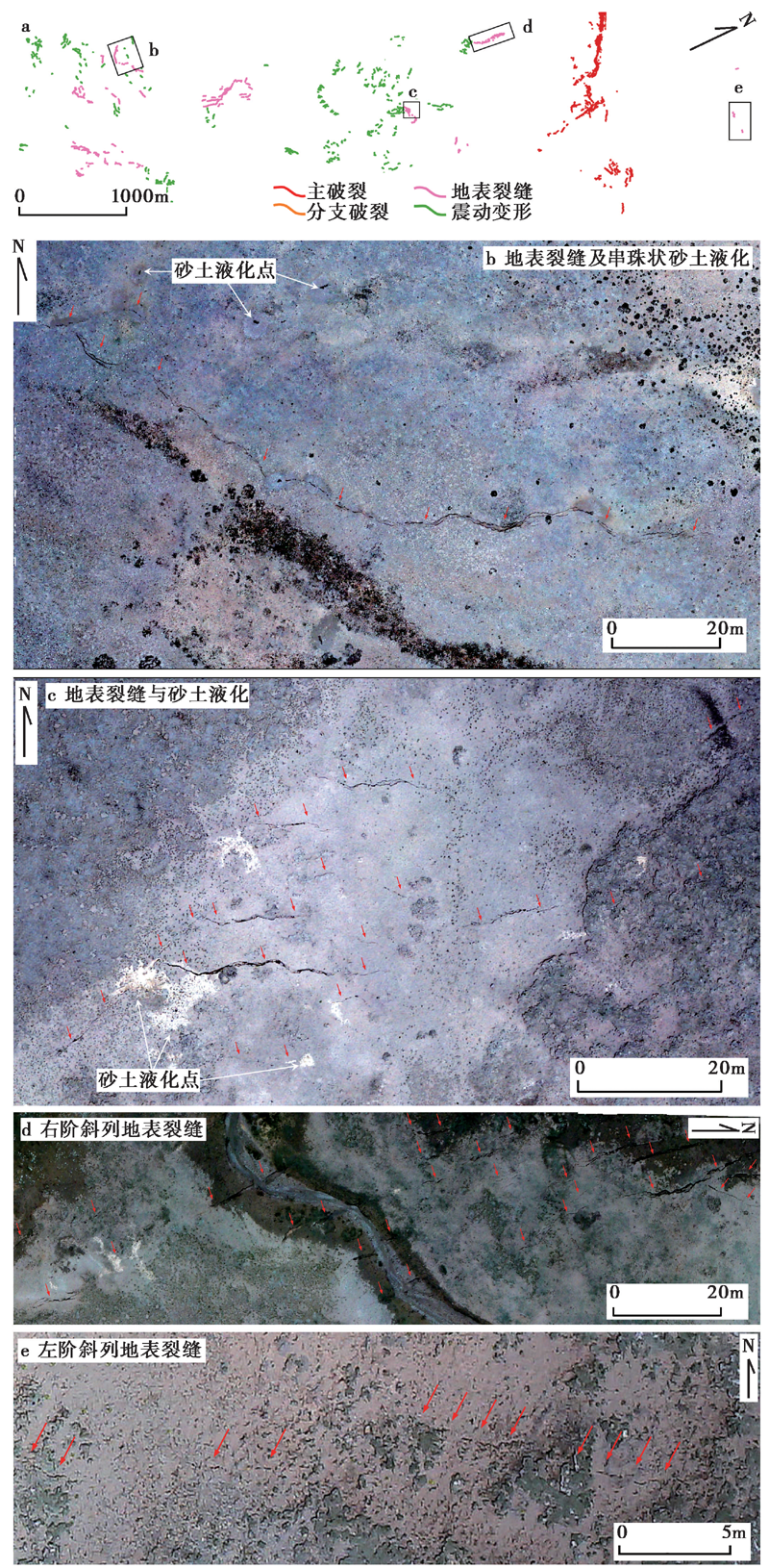
图 7 震中以西12km处的同震地表裂缝 a 总体分布图; b 地表裂缝及串珠状砂土液化; c EW向近平行的地表裂缝及砂土液化点;d NNW向右阶斜列式地表裂缝; f 近EW向左阶斜列地表裂缝
Fig. 7 Coseismic surface fractures about 12km west of the epicenter.
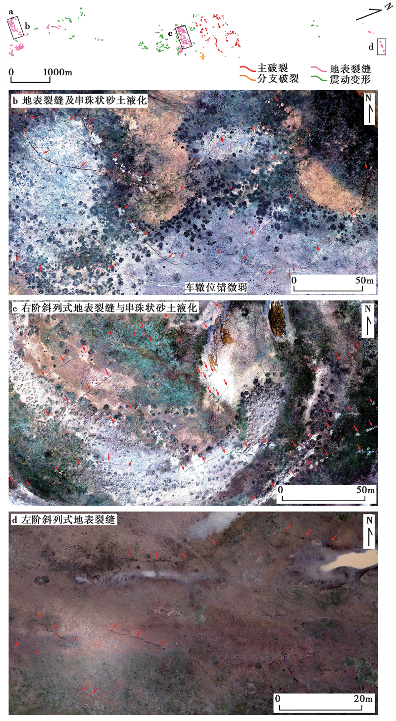
图 8 震中以西20km处的同震地表裂缝 a 总体分布图; b 微弧状地表裂缝及串珠状砂土液化; c NNE向右阶斜列式平直地表裂缝及串珠状砂土液化; d 近NNE向的左阶地表裂缝
Fig. 8 Coseismic surface fractures about 20km west of the epicenter.
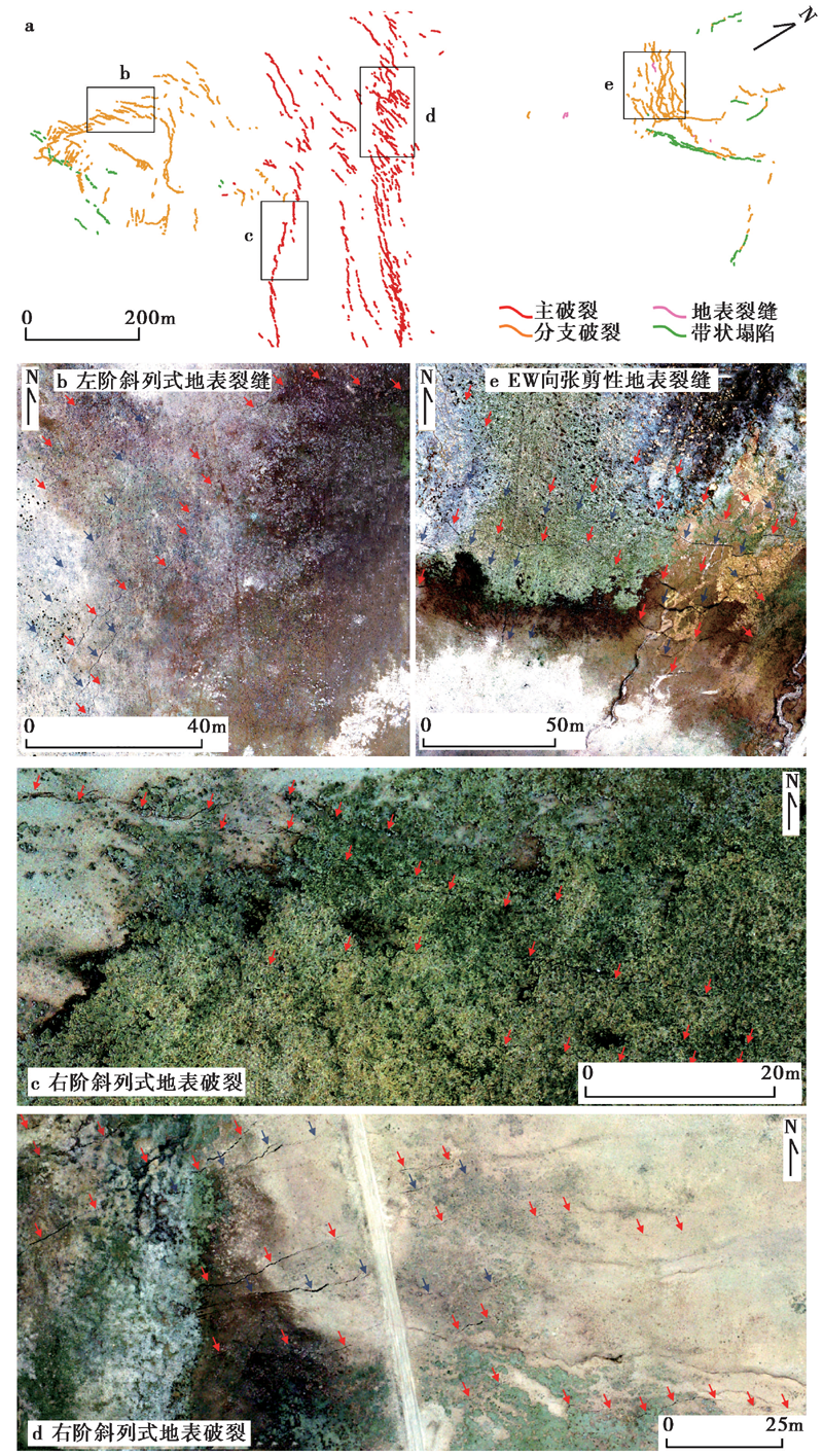
图 9 震中以东28km处的分布式地表破裂 a 总体分布图; b 左阶斜列式地表破裂; c 右阶斜列式地表破裂; d EW向右阶斜列式地表破裂; e EW向张剪性地表破裂
Fig. 9 Coseismic surface ruptures about 28km east of the epicenter.
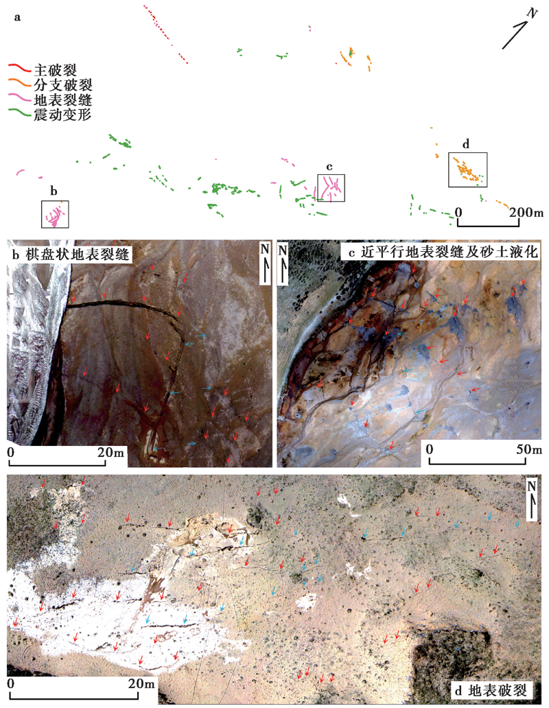
图 10 震中以东50km处的分布式地表裂缝 a 总体分布图; b 棋盘状的地表裂缝; c 近河岸平直的地表裂缝及串珠状砂土液化; d 近EW向的地表破裂及砂土液化
Fig. 10 Coseismic surface fractures about 50km east of the epicenter.
| [1] | 戴华光. 1983. 1947年青海达日$7\frac{3}{4}$级地震[J]. 西北地震学报, 5(3): 71-77. |
| DAI Hua-guang. 1983. On the Dari earthquake of 1947 in Qinghai Province[J]. Northwestern Seismological Journal, 5(3): 71-77. (in Chinese) | |
| [2] | 杜方, 闻学泽, 张培震, 等. 2009. 2008年汶川8.0级地震前横跨龙门山断裂带的震间形变[J]. 地球物理学报, 52(11): 2729-2738. |
| DU Fang, WEN Xue-ze, ZHANG Pei-zhen,et al. 2009. Interseismic deformation across the Longmenshan fault zone before the 2008 M8.0 Wenchuan earthquake[J]. Chinese Journal of Geophysics, 52(11): 2729-2738. (in Chinese) | |
| [3] | 盖海龙, 姚生海, 杨丽萍, 等. 2021. 青海玛多“5·22” MS7.4级地震的同震地表破裂特征、 成因及意义[J]. 地质力学学报, 27(6): 899-912. |
| GAI Hai-long, YAO Sheng-hai, YANG Li-ping,et al. 2021. Characteristics and causes of coseismic surface rupture triggered by the “5·22” MS7.4 earthquake in Maduo, Qinghai, and their significance[J]. Journal of Geomechanics, 27(6): 899-912. (in Chinese) | |
| [4] | 韩龙飞, 刘静, 姚文倩, 等. 2022. 2021年玛多MW7.4地震震中区地表破裂的精细填图及阶区内分布式破裂的讨论[J]. 地震地质, 44(2): 484-505. |
| HAN Long-fei, LIU-ZENG Jing, YAO Wen-qian,et al. 2022. Detailed mapping of the surface rupture near the epicenter segment of the 2021 Madoi MW7.4 earthquake and discussion on distributed rupture in the step-over[J]. Seismology and Geology, 44(2): 484-505. (in Chinese) | |
| [5] | 李智敏, 李文巧, 李涛, 等. 2021. 2021年5月22日青海玛多 MS7.4 地震的发震构造和地表破裂初步调查[J]. 地震地质, 43(3): 722-737. |
| LI Zhi-min, LI Wen-qiao, LI Tao,et al. 2021. Seismogenic fault and coseismic surface deformation of the Maduo MS7.4 earthquake in Qinghai, China: A quick report[J]. Seismology and Geology, 43(3): 722-737. (in Chinese) | |
| [6] | 潘家伟, 白明坤, 李超, 等. 2021. 2021年5月22日青海玛多 MS7.4 地震地表破裂带及发震构造[J]. 地质学报, 95(6): 1655-1670. |
| PAN Jia-wei, BAI Ming-kun, LI Chao,et al. 2021. Coseismic surface rupture and seismogenic structure of the 2021-05-22 Maduo(Qinghai) MS7.4 earthquake[J]. Acta Geologica Sinica, 95(6): 1655-1670. (in Chinese) | |
| [7] | 闻学泽. 2018. 巴颜喀拉块体东边界千年破裂历史与2008年汶川、 2013年芦山和2017年九寨沟地震[J]. 地震学报, 40(3): 255-267. |
| WEN Xue-ze. 2018. The 2008 Wenchuan, 2013 Lushan and 2017 Jiuzhaigou earthquakes, Sichuan, in the last more than one thousand years of rupture history of the eastern margin of the Bayan Har block[J]. Acta Seismologica Sinica, 40(3): 255-267. (in Chinese) | |
| [8] | 熊仁伟, 任金卫, 张军龙, 等. 2010. 玛多-甘德断裂甘德段晚第四纪活动特征[J]. 地震, 30(4): 65-73. |
| XIONG Ren-wei, REN Jin-wei, ZHANG Jun-long,et al. 2010. Late Quaternary active characteristics of the Gande segment of the Maduo-Gande fault zone[J]. Earthquake, 30(4): 65-73. (in Chinese) | |
| [9] | 徐锡伟, 陈桂华, 王启欣, 等. 2017. 九寨沟地震发震断层属性及青藏高原东南缘现今应变状态讨论[J]. 地球物理学报, 60(10): 4018-4026. |
| XU Xi-wei, CHEN Gui-hua, WANG Qi-xin,et al. 2017. Discussion on seismogenic structure of Jiuzhaigou earthquake and its implication for current strain state in the southeastern Qinghai-Tibet Plateau[J]. Chinese Journal of Geophysics, 60(10): 4018-4026. (in Chinese) | |
| [10] | 徐锡伟, 闻学泽, 叶建青, 等. 2008a. 汶川 MS8.0 地震地表破裂带及其发震构造[J]. 地震地质, 30(3): 597-629. |
| XU Xi-wei, WEN Xue-ze, YE Jian-qing,et al. 2008a. The MS8.0 Wenchuan earthquake surface ruptures and its seismogenic structure[J]. Seismology and Geology, 30(3): 597-629. (in Chinese) | |
| [11] | 徐锡伟, 于贵华, 马文涛, 等. 2008b. 昆仑山地震 MW7.8 破裂行为、 变形局部化特征及其构造内涵讨论[J]. 中国科学(D辑), 38(7): 785-796. |
| XU Xi-wei, YU Gui-hua, MA Wen-tao,et al. 2008b. Rupture behavior and deformation localization of the Kunlunshan earthquake( MW7.8 )and their tectonic implications[J]. Science in China(Ser D), 38(7): 785-796. (in Chinese) | |
| [12] | 徐志国, 梁姗姗, 张广伟, 等. 2021. 2021年5月22日青海玛多 MS7.4 地震发震构造分析[J]. 地球物理学报, 64(8): 2657-2670. |
| XU Zhi-guo, LIANG Shan-shan, ZHANG Guang-wei,et al. 2021. Analysis of seismogenic structure of Madoi, Qinghai MS7.4 earthquake on May 22, 2021[J]. Chinese Journal of Geophysics, 64(8): 2657-2670. (in Chinese) | |
| [13] | 姚文倩, 王子君, 刘静, 等. 2022. 2021年青海玛多MW7.4 地震同震地表破裂长度的讨论[J]. 地震地质, 44(2): 541-559. |
| YAO Wen-qian, WANG Zi-jun, LIU-ZENG Jing,et al. 2022 Discussion on coseismic surface rupture length of the 2021 MW7.4 Madoi earthquake, Qinghai, China[J]. Seismology and Geology, 44(2): 541-559. (in Chinese) | |
| [14] | 詹艳, 梁明剑, 孙翔宇, 等. 2021. 2021年5月22日青海玛多 MS7.4 地震深部环境及发震构造模式[J]. 地球物理学报, 64(7): 2232-2252. |
| ZHAN Yan, LIANG Ming-jian, SUN Xiang-yu,et al. 2021. Deep structure and seismogenic pattern of the 2021.5.22 Madoi(Qinghai) MS7.4 earthquake[J]. Chinese Journal of Geophysics, 64(7): 2232-2252. (in Chinese) | |
| [15] | 张培震, 邓起东, 张国民, 等. 2003. 中国大陆的强震活动与活动地块[J]. 中国科学(D辑), 33(S1): 12-20. |
| ZHANG Pei-zhen, DENG Qi-dong, ZHANG Guo-min,et al. 2003. Active tectonic blocks and strong earthquakes in the continent of China[J]. Science in China(Ser D), 33(S1): 12-20. (in Chinese) | |
| [16] | Antoine S L, Klinger Y, Delorme A,et al. 2021. Diffuse deformation and surface faulting distribution from sub-metric image correlation along the 2019 Ridgecrest ruptures(California, USA)[J]. Bulletin of the Seismological Society of America, 111(5): 2275-2302. |
| [17] | Barnhart W D, Gold R D, Hollingsworth J. 2020. Displacement and strain field from the 2019 Ridgecrest earthquakes derived from analysis of World View optical satellite imagery[EB/OL]. [2022-1-28] https://doi.org/10.5066/P9QRZ6NR. |
| [18] | Benjelloun Y, Klinger Y, Antoine S,et al. 2020. Coseismic slip distribution and earthquake recurrence along the Bulnay-Tsetserleg fault zone(Mongolia): Insights from UAV-based photogrammetry and paleoseismology[C]. American Geophysical Union, Fall Meeting 2020, T035-09. |
| [19] | Bryant W A, Sawyer T L. 2002. Quaternary fault and fold database of the United States, Owens Valley fault zone, 1872 rupture section[EB/OL]. [2022-1-28] https://earthquakes.usgs.gov/hazards/qfaults. |
| [20] |
DuRoss C B, Gold R D, Dawson T E,et al. 2020. Surface displacement distributions for the July 2019 Ridgecrest, California, earthquake ruptures[J]. Bulletin of the Seismological Society of America, 110(4): 1400-1418.
DOI URL |
| [21] |
Ferrario M F, Livio F. 2021. Conditional probability of distributed surface rupturing during normal-faulting earthquakes[J]. Solid Earth, 12(5): 1197-1209.
DOI URL |
| [22] | Ferrario M F, Livio F, Michetti A M. 2018. Distributed faulting and partitioning of the deformation in normal-faulting events: Insights from the October 30, 2016 central Italy earthquake( MW6.5 )[C]. SGI-SIMP Congress, Catania. |
| [23] |
Gold R D, Clark D, Barnhart W D,et al. 2019. Surface rupture and distributed deformation revealed by optical satellite imagery: The intraplate 2016 MW6.0 Petermann Ranges earthquake, Australia[J]. Geophysical Research Letters, 46(10): 10394-10403.
DOI URL |
| [24] | Gold R D, DuRoss C B, Barnhart W D. 2021. Coseismic surface displacement in the 2019 Ridgecrest earthquakes: Comparison of field measurements and optical image correlation results[J]. Geochemistry, Geophysics, Geosystems, 22(3): 1-22. |
| [25] | Handy M R, Hirth G, Bürgmann R. 2007. Continental fault structure and rheology from the frictional-to-viscous transition downward [G]//Handy M R, Hirth G, Hovius N. Tectonic Faults: Agents of Change on a Dynamic Earth. MIT Press, Cambridge: 139-182. |
| [26] | Hudnut K, Seeber L, Rockwell T,et al. 1989. Surface ruptures on cross-faults in the 24 November 1987 Superstition Hills, California, earthquake sequence[J]. Bulletin of the Seismological Society of America, 79(2): 282-296. |
| [27] |
Klinger Y, Okubo K, Vallage A,et al. 2018. Earthquake damage patterns resolve complex rupture processes[J]. Geophysical Research Letters, 45(19): 10279-10287.
DOI URL |
| [28] |
Koehler R D, Dee S, Elliott A,et al. 2021. Field response and surface-rupture characteristics of the 2020 M6.5 Monte Cristo Range earthquake, Central Walker Lane, Nevada[J]. Seismological Research Letters, 92(2A): 823-839.
DOI URL |
| [29] |
Liu J, Sieh K, Hauksson E. 2003. A structural interpretation of the aftershock “cloud” of the 1992 MW7.3 Landers earthquake[J]. Bulletin of the Seismological Society of America, 93: 1333-1344.
DOI URL |
| [30] |
Liu-Zeng J, Zhang Z, Wen L,et al. 2009. Co-seismic ruptures of the 12 May 2008, MS8.0 Wenchuan earthquake, Sichuan: East-west crustal shortening on oblique, parallel thrusts along the eastern edge of Tibet[J]. Earth and Planetary Science Letters, 286(3-4): 355-370.
DOI URL |
| [31] |
Livio F, Serva L, Gürpinar A. 2016. Locating distributed faulting: Contributions from InSAR imaging to probabilistic fault displacement hazard analysis(PFDHA)[J]. Quaternary International, 451: 223-233.
DOI URL |
| [32] |
Michel R, Avouac J P. 2006. Coseismic surface deformation from air photos: The Kickapoo step over in the 1992 Landers rupture[J]. Journal of Geophysical Research, 111(B3): B03408. doi: 10.1029/2005JB003776.
DOI |
| [33] |
Nurminen F, Boncio P, Visini F,et al. 2020. Probability of occurrence and displacement regression of distributed surface rupturing for reverse earthquakes[J]. Frontiers in Earth Science, 8: 293-306.
DOI URL |
| [34] |
Oskin M E, Arrowsmith J R, Corona A H,et al. 2012. Near-field deformation from the El Mayor-Cucapah earthquake revealed by differential LIDAR[J]. Science, 335(6069): 702-705.
DOI URL |
| [35] | Parker J, Donnellan A, Bilham R,et al. 2021. Buried aseismic slip and off-fault deformation on the southernmost San Andreas Fault triggered by the 2010 El Mayor Cucapah earthquake revealed by UAVSAR[J]. Earth and Space Science, 8(8): 1-19. |
| [36] |
Petersen M, Dawson T E, Chen R,et al. 2011. Fault displacement hazard for strike-slip faults[J]. Bulletin of the Seismological Society of America, 101(2): 805-825.
DOI URL |
| [37] |
Ponti D J, Blair J L, Rosa C M,et al. 2020. Documentation of surface fault rupture and ground-deformation features produced by the 4 and 5 July 2019 MW6.4 and MW7.1 Ridgecrest earthquake sequence[J]. Seismological Research Letters, 91(5): 2942-2959.
DOI URL |
| [38] | Scholz C H. 1982. Scaling laws for large earthquakes: Consequences for physical models[J]. Bulletin of the Seismological Society of America, 72(1): 1-14. |
| [39] |
Sibson R H, Scott J. 1998. Stress/fault controls on the containment and release of overpressured fluids: Examples from gold-quartz vein systems in Juneau, Alaska; Victoria, Australia and Otago, New Zealand[J]. Ore Geology Reviews, 13(1-5): 293-306.
DOI URL |
| [40] |
Sylvester A G. 1988. Strike-slip faults[J]. Geological Society of America Bulletin, 100(11): 1666-1703.
DOI URL |
| [41] |
Tapponnier P, Peltzer G, Le Dain A Y,et al. 1982. Propagating extrusion tectonics in Asia: New insights from simple experiments with plasticine[J]. Geology, 10(12): 611-616.
DOI URL |
| [42] |
Tapponnier P, Xu Z Q, Roger F,et al. 2001. Oblique stepwise rise and growth of the Tibet plateau[J]. Science, 294(5547): 1671-1677.
PMID |
| [43] |
Thompson J J A, Philibosian B, Chupik C,et al. 2020. Evidence of previous faulting along the 2019 Ridgecrest, California, earthquake ruptures[J]. Bulletin of the Seismological Society of America, 110(4): 1427-1456.
DOI URL |
| [44] | Wells D L, Coppersmith K J. 1994. New empirical relationships among magnitude, rupture length, rupture width, rupture area, and surface displacement[J]. Bulletin of the Seismological Society of America, 84(4): 974-1002. |
| [45] |
Wesnousky S G. 2008. Displacement and geometrical characteristics of earthquake surface ruptures: Issues and implications for seismic-hazard analysis and the process of earthquake rupture[J]. Bulletin of the Seismological Society of America, 98(4): 1609-1632.
DOI URL |
| [46] |
Youngs R R, Arabasz W J, Anderson R E,et al. 2003. A methodology for probabilistic fault displacement hazard analysis(PFDHA)[J]. Earthquake Spectra, 19(1): 191-219.
DOI URL |
| [47] |
Zachariasen J, Sieh K. 1995. The transfer of slip between two en echelon strike-slip faults: A case study from the 1992 Landers earthquake, southern California[J]. Journal of Geophysical Research, 100(B8): 15281-15301. doi: 10.1029/95JB00918.
DOI URL |
| [48] | Zhao D, Qu C, Chen H,et al. 2021. Tectonic and geometric control on fault kinematics of the 2021 MW7.3 Maduo(China)earthquake inferred from interseismic, coseismic, and postseismic InSAR observations[J]. Geophysical Research Letters, 48(18): 1-12. |
| [1] | 乔俊香, 石峰, 李安, 李涛, 张达, 王鑫, 格桑旦珍, 孙浩越. 高分影像在2025年1月7日西藏定日MS6.8地震同震地表破裂调查中的应用[J]. 地震地质, 2025, 47(3): 789-805. |
| [2] | 石峰, 梁明剑, 罗全星, 乔俊香, 张达, 王鑫, 易文星, 张佳伟, 张迎峰, 张会平, 李涛, 李安. 2025年1月7日西藏定日6.8级地震发震构造与同震地表破裂特征[J]. 地震地质, 2025, 47(1): 1-15. |
| [3] | 游子成, 毕海芸, 郑文俊, 彭慧, 梁淑敏, 段磊, 覃乙根. 基于高分辨率遥感影像的地震破裂带精细特征研究——以理塘断裂为例[J]. 地震地质, 2023, 45(5): 1057-1073. |
| [4] | 吴中海, 白玛多吉, 叶强, 韩帅, 史亚然, 尼玛次仁, 高扬. 西藏阿里阿鲁错地堑系的第四纪活动性、最新同震地表破裂及其地震地质意义[J]. 地震地质, 2023, 45(1): 67-91. |
| [5] | 邓文泽, 刘杰, 杨志高, 孙丽, 张雪梅. 青海玛多MS7.4地震震源破裂过程反演结果的初步分析[J]. 地震地质, 2022, 44(4): 1059-1070. |
| [6] | 魏延坤, 陈晓利. 不同地震滑坡危险性评价方法的适用性探讨——以玛多MS7.4地震为例[J]. 地震地质, 2022, 44(3): 590-603. |
| [7] | 姚文倩, 王子君, 刘静, 刘小利, 韩龙飞, 邵延秀, 王文鑫, 徐晶, 秦可心, 高云鹏, 王焱, 李金阳, 曾宪阳. 2021年青海玛多MW7.4地震同震地表破裂长度的讨论[J]. 地震地质, 2022, 44(2): 541-559. |
| [8] | 邵延秀, 刘静, 高云鹏, 王文鑫, 姚文倩, 韩龙飞, 刘志军, 邹小波, 王焱, 李云帅, 刘璐. 同震地表破裂的位移测量与弥散变形分析——以2021年青海玛多MW7.4地震为例[J]. 地震地质, 2022, 44(2): 506-523. |
| [9] | 韩龙飞, 刘静, 姚文倩, 王文鑫, 刘小利, 高云鹏, 邵延秀, 李金阳. 2021年玛多MW7.4地震震中区地表破裂的精细填图及阶区内的分布式破裂讨论[J]. 地震地质, 2022, 44(2): 484-505. |
| [10] | 盖海龙, 李智敏, 姚生海, 李鑫. 2022年青海门源MS6.9地震地表破裂特征的初步调查研究[J]. 地震地质, 2022, 44(1): 238-255. |
| [11] | 谈洪波, 王嘉沛, 杨光亮, 陈正松, 吴桂桔, 申重阳, 黄金水. 2021年玛多MS7.4地震的震后效应模拟[J]. 地震地质, 2021, 43(4): 936-957. |
| [12] | 李智敏, 李文巧, 李涛, 徐岳仁, 苏鹏, 郭鹏, 孙浩越, 哈广浩, 陈桂华, 袁兆德, 李忠武, 李鑫, 杨理臣, 马震, 姚生海, 熊仁伟, 张彦博, 盖海龙, 殷翔, 徐玮阳, 董金元. 2021年5月22日青海玛多MS7.4地震的发震构造和地表破裂初步调查[J]. 地震地质, 2021, 43(3): 722-737. |
| [13] | 华俊, 赵德政, 单新建, 屈春燕, 张迎峰, 龚文瑜, 王振杰, 李成龙, 李彦川, 赵磊, 陈晗, 范晓冉, 王绍俊. 2021年青海玛多MW7.3地震InSAR的同震形变场、断层滑动分布及其对周边区域的应力扰动[J]. 地震地质, 2021, 43(3): 677-691. |
| [14] | 郝海健, 何宏林, 魏占玉, 石峰. 同震地表破裂及活动断层迹线的几何形貌特征[J]. 地震地质, 2017, 39(6): 1267-1282. |
| [15] | 韩竹军, Nicola Litchfield, 冉洪流, 袁仁茂, 郭鹏, Robert M Langridge, Russ J Van Dissen. 新西兰2016年凯库拉MW7.8地震地表破裂带特征初析[J]. 地震地质, 2017, 39(4): 675-688. |
| 阅读次数 | ||||||
|
全文 |
|
|||||
|
摘要 |
|
|||||
