地震地质 ›› 2021, Vol. 43 ›› Issue (6): 1657-1670.DOI: 10.3969/j.issn.0253-4967.2021.06.017

• 新技术应用 • 上一篇    下一篇

基于无人机热红外遥感数据的地震倒塌房屋提取

范熙伟1,2)(), 聂高众1,2),*(), 邓砚1,2), 安基文1,2), 夏朝旭1,2)   

  1. 1)中国地震局地震与火山灾害重点实验室, 北京 100029
    2)中国地震局地质研究所, 北京 100029
  • 收稿日期:2020-10-09 修回日期:2021-01-29 出版日期:2021-12-20 发布日期:2022-01-29
  • 通讯作者: 聂高众
  • 作者简介:范熙伟, 男, 1986年生, 2015年于中国科学院地理科学与资源研究所获地图学与地理信息系统专业博士学位, 现为中国地震局地质研究所副研究员, 主要研究方向为地震灾害与应急、 灾害遥感, 电话: 010-62009090, E-mail: fanxiwei@ies.ac.cn
  • 基金资助:
    国家重点研发计划项目(2018YFC1504403);国家重点研发计划项目(2018YFC1504503);国家自然科学基金(42071337)

EARTHQUAKE BUILDING DAMAGE DETECTION USING UAV THERMAL INFRARED REMOTE SENSING IMAGES

FAN Xi-wei1,2)(), NIE Gao-zhong1,2),*(), DENG Yan1,2), AN Ji-wen1,2), XIA Chao-xu1,2)   

  1. 1) Key Laboratory of Seismic and Volcanic Hazards, China Earthquake Administration, Beijing 100029, China
    2) Institute of Geology, China Earthquake Administration, Beijing 100029, China
  • Received:2020-10-09 Revised:2021-01-29 Online:2021-12-20 Published:2022-01-29
  • Contact: NIE Gao-zhong

摘要:

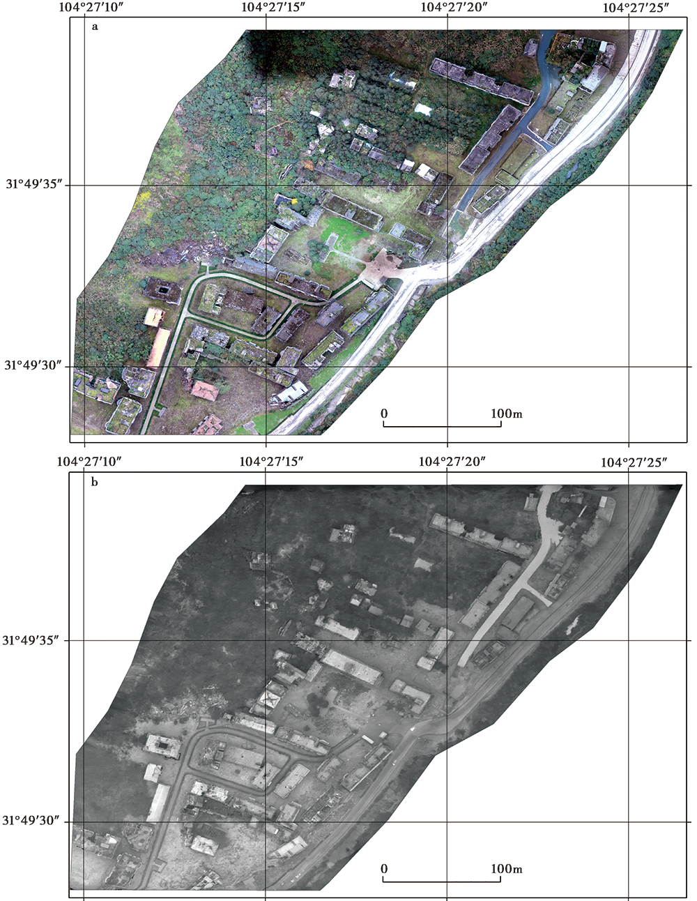
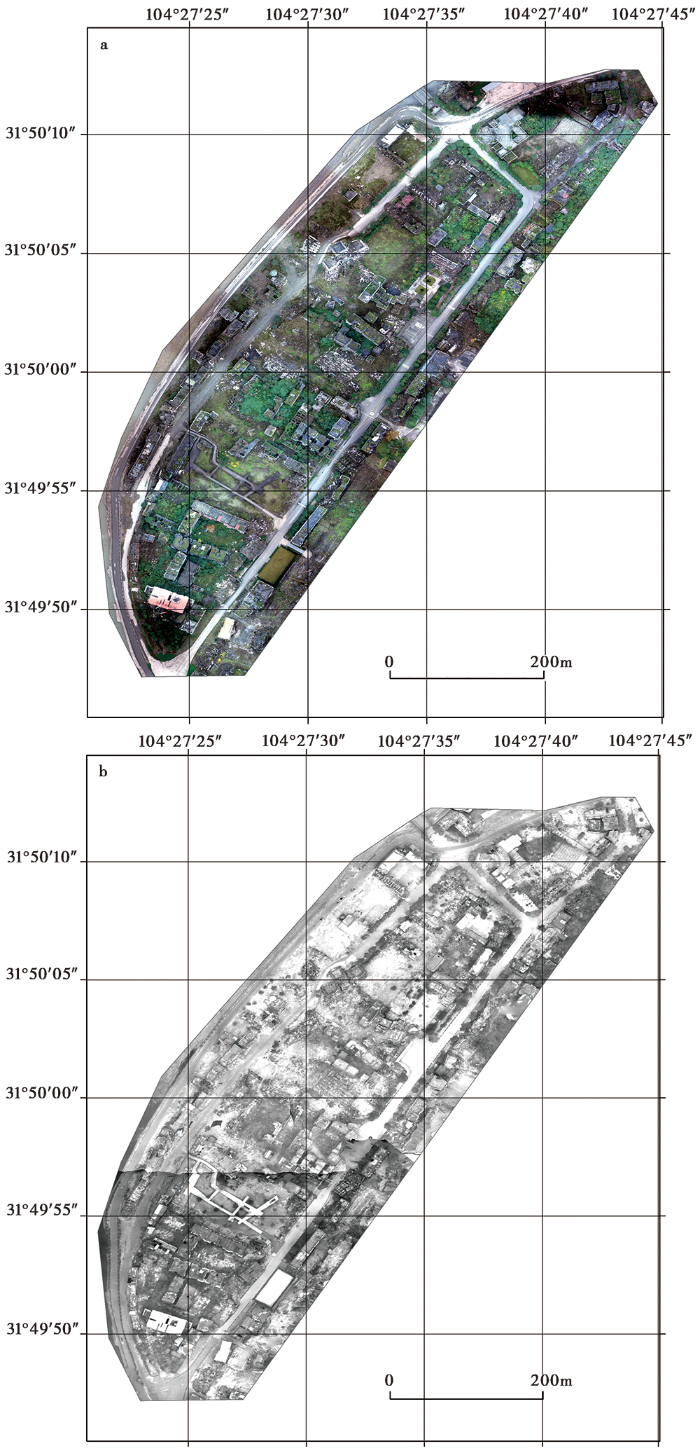
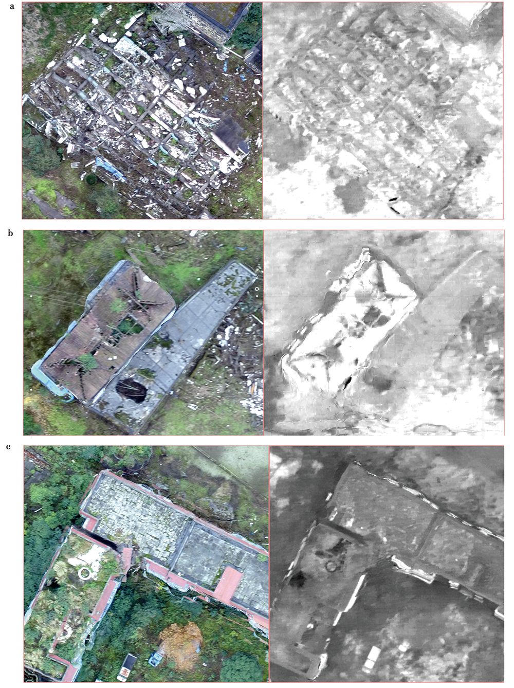
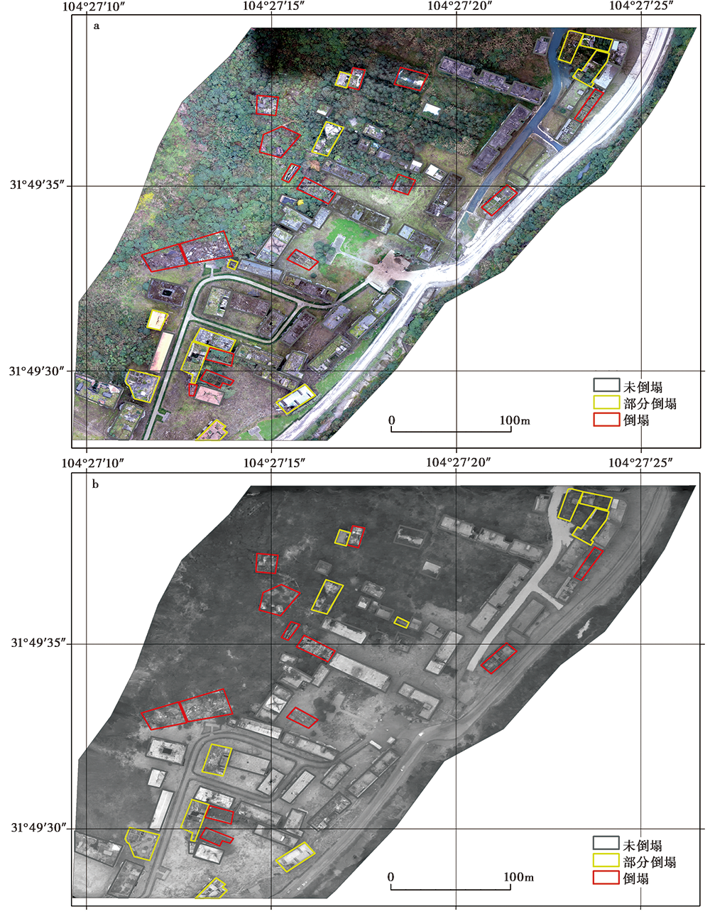
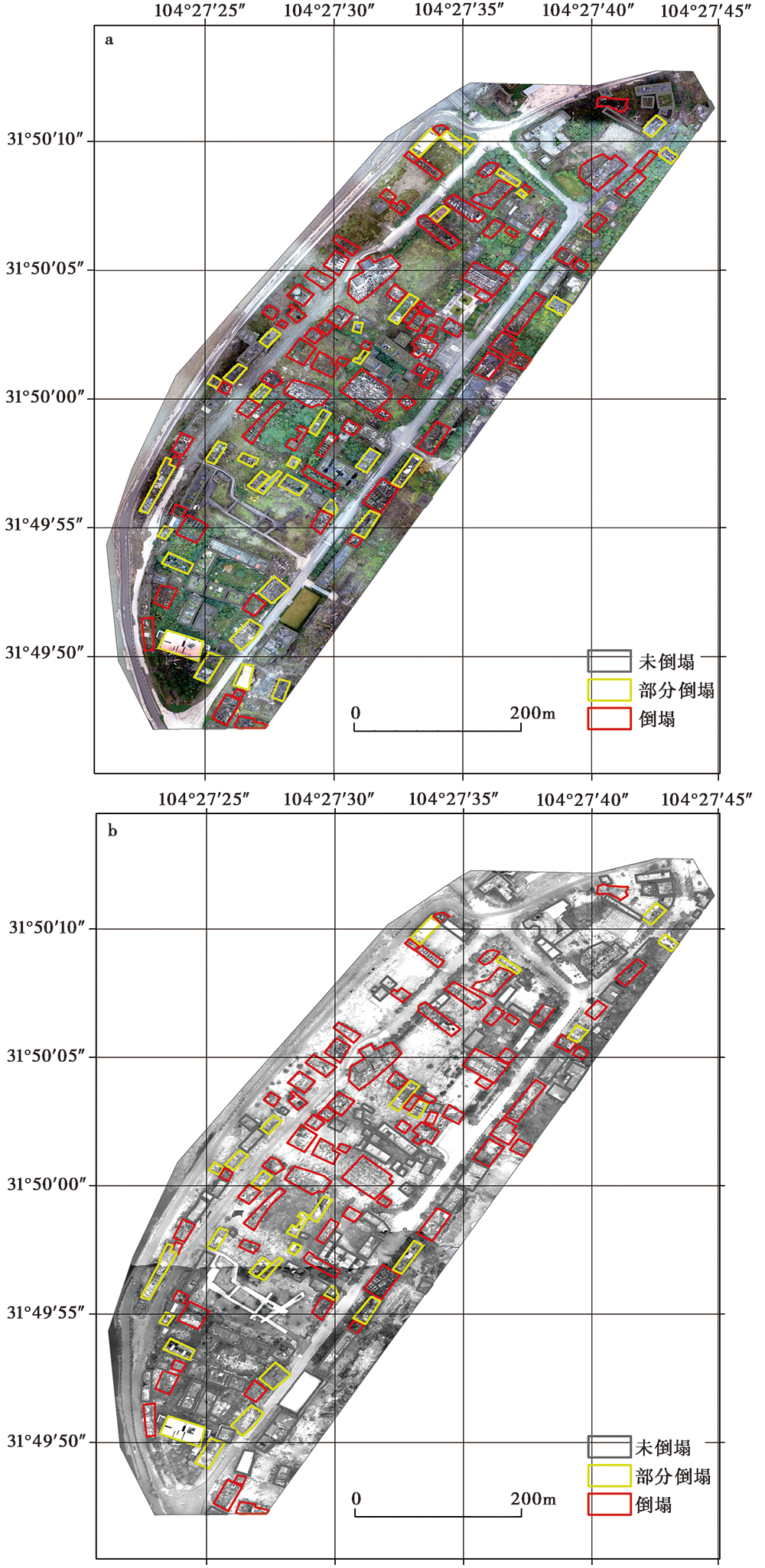
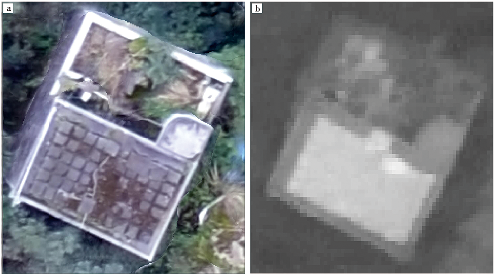
遥感技术具有高效、 快速获取大范围地表信息的能力, 因而被广泛应用于建筑物分布和高度等参数的获取, 以及震后灾情快速获取等工作, 如震后倒塌房屋的研判和提取、 震后滑坡、 堰塞湖等次生灾害的识别等。但是, 目前常用的可见光遥感技术无法在夜间获取信息。为了提高震后夜间获取灾情信息的能力, 文中以北川地震遗址作为研究区, 尝试利用无人机获取热红外遥感数据, 并进行倒塌房屋的提取研究。将可见光遥感数据提取的倒塌房屋作为真值进行对比, 发现热红外遥感数据可用于夜间倒塌房屋的识别, 其总体精度为0.86, 其中3种破坏类型房屋的用户精度都在0.8以上。

关键词: 地震, 热红外数据, 无人机, 倒塌房屋

Abstract:

Remote sensing is widely used for large-scale land surface information acquisition, such as land surface temperature estimation, land use and land cover classifications. Compared with in-situ field investigation, remote sensing has many advantages of efficiency and cost saving of human and material resources. As for the seismic risk reduction, the building area extraction, building height and other parameters acquisition, building structure type classification, and identification of post-earthquake building collapse, earthquake induced landslide, quake lake and other secondary disasters are the most important parts of remote sensing applications.
The high- or mid-spatial resolution visible images of centimeters to meters acquired from airborne and spaceborne instruments are widely used for damage building identifications, such as the April 14th Yushu earthquake in 2010. But the visible images cannot be used for nighttime land surface information acquisition. Thus, the active remote sensing techniques such as SAR or LiDAR are effective substitution for nighttime earthquake disaster information acquisitions. But the SAR and LiDAR data are not shown in traditional way which are similar with the visible images, and can only be interpreted by professional researchers. Note that some of the earthquakes occurred during the nighttime, for example the July 28th Tangshan earthquake occurred at the local time of 3:42. The nighttime earthquake disaster information acquisition is as important as the daytime. Considering the thermal infrared(TIR)sensor can receive thermal radiances emitted by surface features with the wavelength of 3 to 100μm and independent on solar radiations, this study tries to use TIR data acquired during nighttime to identify earthquake building damage types.
This study takes the Beichuan earthquake site of the Wenchuan earthquake in 2008 as the research area. To acquire TIR image of the study area, the UAV of DJI M200 version 2 with the payload of ZENMUSE XT2 is used. The XT2 has two cameras, with one traditional RGB visible camera and one TIR camera with the center wavelength of 10μm and spectral range of 7.5~13.5μm. The focal plane of XT2 have pixels of 4 000×3 000 for the visible camera and 640×512 for TIR camera. The pixel size of the TIR camera focal plane is 17μm and the focal length is 13mm. The M200 used in this study was flying at a height of 120m above ground. Thus the spatial resolution of the corresponding TIR image is about 15.7cm for vertical view condition. The TIR images of old town and new town of Beichuan county-seat are acquired with M200.
To evaluate the accuracy of identification of the damaged buildings using UAV TIR data, the visible images of the study areas are also acquired during the daytime and taken as reference. After mosaicing the daytime visible images and nighttime TIR images, respectively, all the buildings in the study area are classified into three damage types by artificial interpretation: slight damage, moderate damage, and destruction. By comparing the damaged building types by visible remote sensing data as the true value, the confuse matrix are constructed for the TIR data estimated building damage types. It is found that the UAV TIR remote sensing data can be used for the identification of damaged buildings at night, and the overall accuracy is 0.86, among which the user accuracy of the three damage types are all larger than 0.8. The mapping accuracy is 0.95, 0.67, and 0.84, for slight damage, moderate damage, and destruction types, respectively. The accuracy of moderate damage is 0.67. This is because the TIR image has only one channel and cannot show colors. Thus the moderate damage buildings are confused with trees and other features.

Key words: earthquakes, thermal infrared image, UAV, collapsed buildings

中图分类号: