地震地质 ›› 2022, Vol. 44 ›› Issue (2): 524-540.DOI: 10.3969/j.issn.0253-4967.2022.02.015
• 2021年玛多地震地表破裂机理研究专题文章 • 上一篇 下一篇
王文鑫1)( ), 邵延秀1),*(), 姚文倩1), 刘静1,2), 韩龙飞1), 刘小利3), 高云鹏1), 王子君1), 秦可心1), 屠泓为4)
收稿日期:2022-01-25
修回日期:2022-03-19
出版日期:2022-04-20
发布日期:2022-06-14
通讯作者:
邵延秀
作者简介:王文鑫, 男, 1995年生, 现为天津大学地球系统科学学院环境科学专业在读博士研究生, 主要从事地表侵蚀与地貌演化方面的研究, E-mail: wenxinwwx_1995@tju.edu.cn。
基金资助:
WANG Wen-xin1)(), SHAO Yan-xiu1),*(), YAO Wen-qian1), LIU-ZENG Jing1,2), HAN Long-fei1), LIU Xiao-li3), GAO Yun-peng1), WANG Zi-jun1), QIN Ke-xin1), TU Hong-wei4)
Received:2022-01-25
Revised:2022-03-19
Online:2022-04-20
Published:2022-06-14
Contact:
SHAO Yan-xiu
摘要:
掌握精确地震的地表破裂带特征是探讨大地震破裂特征和发震机理的重要基础。摄影测量技术为快速获取高精度、 高分辨率地表破裂带的空间展布提供了有力支撑。文中以玛多 MW7.4 地震为例, 详细介绍了摄影测量技术在震后快速准确地进行地表破裂解译及相关特征参数提取中的应用。通过无人机摄影测量技术, 在较短时间内获得了地震全段地表破裂的数字正射影像以及多个形变复杂区域厘米级分辨率的数字高程模型, 可满足震后快速获取同震地表破裂带特征的需要。对正射影像测量的地表破裂水平位错结果与野外实地测量结果进行对比, 可证明无人机摄影测量技术所得数据的真实性和可靠性。利用移动智能设备搭载的LiDAR传感器, 结合增强现实技术(Augmented reality, AR), 实现了如挤压鼓包等复杂地表破裂的室内重现, AR成像模型与实景高度融合, 为地质教学及科研工作提供了一种新的方法和思路。研究结果显示, 摄影测量技术在活动构造定量化、 精细化研究中具有巨大的应用潜力。
中图分类号:
王文鑫, 邵延秀, 姚文倩, 刘静, 韩龙飞, 刘小利, 高云鹏, 王子君, 秦可心, 屠泓为. 基于摄影测量技术对玛多MW7.4地震地表破裂特征的快速提取及三维结构的室内重建[J]. 地震地质, 2022, 44(2): 524-540.
WANG Wen-xin, SHAO Yan-xiu, YAO Wen-qian, LIU-ZENG Jing, HAN Long-fei, LIU Xiao-li, GAO Yun-peng, WANG Zi-jun, QIN Ke-xin, TU Hong-wei. RAPID EXTRACTION OF FEATURES AND INDOOR RECON-STRUCTION OF 3D STRUCTURES OF MADOI MW7.4 EARTHQUAKE SURFACE RUPTURES BASED ON PHOTOGRAMMETRY METHOD[J]. SEISMOLOGY AND GEOLOGY, 2022, 44(2): 524-540.
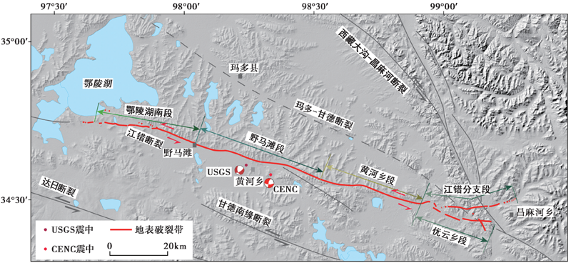
图 1 玛多 MW7.4 地震的构造背景图 图中地表破裂带为作者所在团队利用航拍技术获取的较精细的破裂带分布简图
Fig. 1 Seismogenic tectonic background map of the Madoi MW7.4 earthquake.
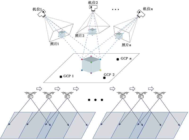
图 2 SfM方法的基本原理(修改自Westoby et al., 2012; 毕海芸等, 2017)
Fig. 2 Basic principle of SfM method(adapted after Westoby et al., 2012; BI Hai-yun et al., 2017).
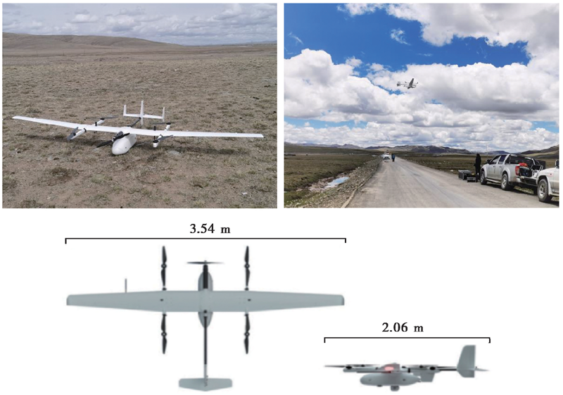
图 3 CW-15垂直起降固定翼无人机的外观及野外作业图
Fig. 3 Appearance and field operation diagram of CW-15 VTOL fixed-wing UAV.
| 指标 | 参数 |
|---|---|
| 机身长度/翼展 | 2.06m/3.54m |
| 最大起飞重量 | 17kg |
| 任务载荷 | ≤3kg |
| 带载续航能力 | 120~180min |
| 抗风能力 | 6级(10.8~13.8m/s) |
| 起飞海拔/实用升限 | 4500m/6500m |
| 垂直方向定位精度 | 3cm |
| 水平方向定位精度 | 1cm+1ppm |
| 影像传感器 | CA103全画幅正射相机+DS100旋偏云台 |
表1 CW-15垂直起降固定翼无人机系统的主要参数
Table1 Main parameters of CW-15 VTOL fixed-wing UAV system
| 指标 | 参数 |
|---|---|
| 机身长度/翼展 | 2.06m/3.54m |
| 最大起飞重量 | 17kg |
| 任务载荷 | ≤3kg |
| 带载续航能力 | 120~180min |
| 抗风能力 | 6级(10.8~13.8m/s) |
| 起飞海拔/实用升限 | 4500m/6500m |
| 垂直方向定位精度 | 3cm |
| 水平方向定位精度 | 1cm+1ppm |
| 影像传感器 | CA103全画幅正射相机+DS100旋偏云台 |
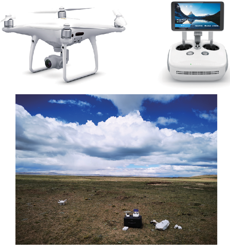
图 4 大疆精灵Phantom 4 Pro V2.0无人机的外观及野外作业图
Fig. 4 Appearance and field operation diagram of DJI Phantom 4 Pro V2.0 UAV.
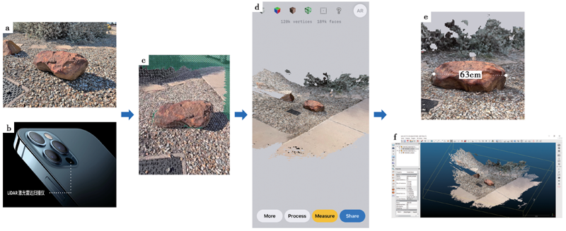
图5 iPhone 12 Pro激光雷达扫描仪的AR成像示意图(图片资料来自网页①(① https://opentopography.org/blog/iphone-lidar-applications-geosciences。)) a 扫描对象的照片; b iPhone 12 Pro激光雷达扫描仪; c 扫描过程中的纹理格网覆盖; d 完成对扫描对象及其周围环境的扫描; e 扫描对象的长度测量; f 扫描对象的三维建模
Fig. 5 Schematic diagram of AR imaging for iPhone 12 Pro LiDAR scanner(Image data from webpage①).
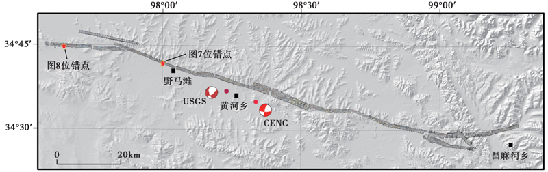
图 6 CW-15无人机航拍的正射影像覆盖的区域
Fig. 6 Coverage area of CW-15 UAV aerial orthophoto image.
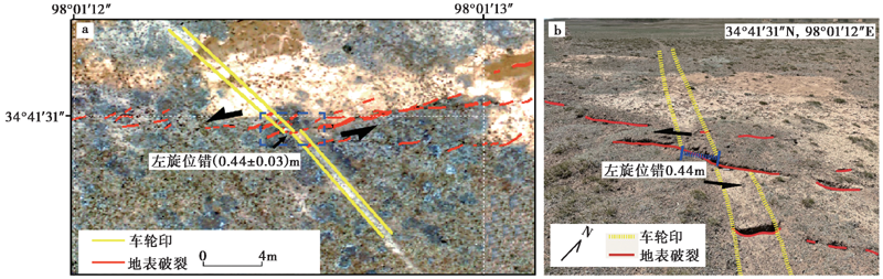
图 7 摩托车车辙印左旋位错的影像解译(a)及现场实地测量结果(b)
Fig. 7 Image interpretation(a)and field measurement(b)of left-lateral offset in motorcycle wheel mark.
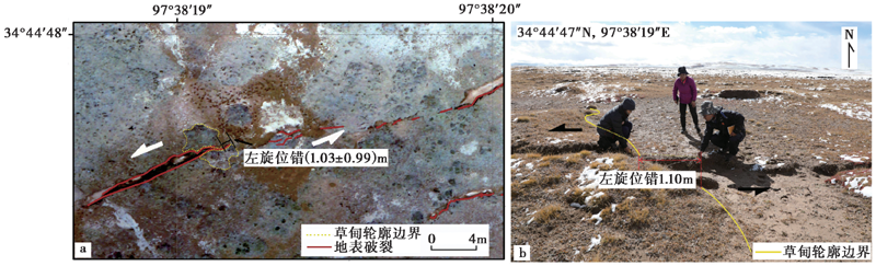
图 8 草甸左旋位错的影像解译(a)及现场实地测量结果(b)
Fig. 8 Image interpretation(a)and field measurement(b)of left-lateral offset in meadow.
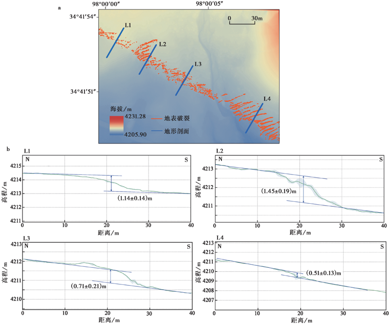
图 9 基于无人机摄影测量技术获取的高精度区域DEM(a)及垂直断错(b)
Fig. 9 High-precision region DEM(a)and vertical offset(b)obtained by UAV photogrammetry.
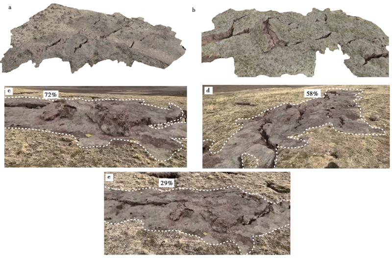
图 10 地表破裂、 挤压鼓包的AR成像图 a、 b 地表破裂、 挤压鼓包的室内AR成像; c—e 地表破裂、 挤压鼓包的野外AR成像
Fig. 10 AR imaging of surface ruptures and pressure ridges.
| [1] |
艾明, 毕海芸, 郑文俊, 等. 2018. 利用无人机摄影测量技术提取活动构造定量参数[J]. 地震地质, 40(6): 1276-1293. doi: 10.3969/j.issn.0253-4967.2018.06.006.
DOI |
| AI Ming, BI Hai-yun, ZHENG Wen-jun,et al. 2018. Using unmanned aerial vehicle photogrammetry technology to obtain quantitative parameters of active tectonics[J]. Seismology and Geology, 40(6): 1276-1293. (in Chinese) | |
| [2] |
毕海芸, 郑文俊, 曾江源, 等. 2017. SfM摄影测量方法在活动构造定量研究中的应用[J]. 地震地质, 39(4): 656-674. doi: 10.3969/j.issn.0253-4967.2017.04.003.
DOI |
| BI Hai-yun, ZHENG Wen-jun, ZENG Jiang-yuan,et al. 2017. Application of SfM photogrammetry method to the quantitative study of active tectonics[J]. Seismology and Geology, 39(4): 656-674. (in Chinese) | |
| [3] | 陈桂华, 徐锡伟, 闻学泽, 等. 2006. 数字航空摄影测量学方法在活动构造中的应用[J]. 地球科学(中国地质大学学报), 31(3): 405-410. |
| CHEN Gui-hua, XU Xi-wei, WEN Xue-ze,et al. 2006. Application of digital aerophotogrammetry in active tectonics[J]. Earth Science(Journal of China University of Geosciences), 31(3): 405-410. (in Chinese) | |
| [4] | 陈晓勇, 何海清, 周俊超, 等. 2019. 低空摄影测量立体影像匹配的现状与展望[J]. 测绘学报, 48(12): 1595-1603. |
| CHEN Xiao-yong, HE Hai-qing, ZHOU Jun-chao,et al. 2019. Progress and future of image matching in low-altitude photogrammetry[J]. Acta Geodaetica et Cartographica Sinica, 48(12): 1595-1603. (in Chinese) | |
| [5] | 程争刚, 张利. 2016. 一种基于无人机位姿信息的航拍图像拼接方法[J]. 测绘学报, 45(6): 698-705. |
| CHENG Zheng-gang, ZHANG Li. 2016. An aerial image mosaic method based on UAV position and attitude information[J]. Acta Geodaetica et Cartographica Sinica, 45(6): 698-705. (in Chinese) | |
| [6] | 邓起东, 陈立春, 冉勇康. 2004. 活动构造定量研究与应用[J]. 地学前缘, 11(4): 383-392. |
| DENG Qi-dong, CHEN Li-chun, RAN Yong-kang. 2004. Quantitative studies and applications of active tectonics[J]. Earth Science Frontiers, 11(4): 383-392. (in Chinese) | |
| [7] | 盖海龙, 姚生海, 杨丽萍, 等. 2021. 青海玛多“5·22” MS7.4 地震的同震地表破裂特征、 成因及意义[J]. 地质力学学报, 27(6): 899-912. |
| GAI Hai-long, YAO Sheng-hai, YANG Li-ping,et al. 2021. Characteristics and causes of coseismic surface rupture triggered by the “5·22” MS7.4 earthquake in Maduo, Qinghai, and their significance[J]. Journal of Geomechanics, 27(6): 899-912. (in Chinese) | |
| [8] | 龚健雅, 季顺平. 2018. 摄影测量与深度学习[J]. 测绘学报, 47(6): 693-704. |
| GONG Jian-ya, JI Shun-ping. 2018. Photogrammetry and deep learning[J]. Acta Geodaetica et Cartographica Sinica, 47(6): 693-704. (in Chinese) | |
| [9] | 韩龙飞, 刘静, 姚文倩, 等. 2022. 2021年玛多MW7.4地震震中区地表破裂的精细填图及阶区内分布式破裂的讨论[J]. 地震地质, 44(2): 484-505. |
| HAN Long-fei, LIU-ZENG Jing, YAO Wen-qian,et al. 2022. Detailed mapping of the surface rupture near the epicenter segment of the 2021 Madoi MW7.4 earthquake and discussion on distributed rupture in the step-over[J]. Seismology and Geology, 44(2): 484-505. (in Chinese) | |
| [10] |
李智敏, 李文巧, 李涛, 等. 2021. 2021年5月22日青海玛多 MS7.4 地震的发震构造和地表破裂初步调查[J]. 地震地质, 43(3): 722-737. doi: 10.3969/j.issn.0253-4967.2021.03.016.
DOI |
| LI Zhi-min, LI Wen-qiao, LI Tao,et al. 2021. Seismogenic fault and coseismic surface deformation of the Maduo MS7.4 earthquake in Qinghai, China: A quick report[J]. Seismology and Geology, 43(3): 722-737. (in Chinese) | |
| [11] | 刘静, 陈涛, 张培震, 等. 2013. 机载激光雷达扫描揭示海原断裂带微地貌的精细结构[J]. 科学通报, 58(1): 41-45. |
| LIU-ZENG Jing, CHEN Tao, ZHANG Pei-zhen,et al. 2013. Illuminating the active Haiyuan Fault, China by airborne light detection and ranging[J]. Chinese Science Bulletin, 58(1): 41-45. (in Chinese) | |
| [12] | 刘静, 张金玉, 葛玉魁, 等. 2018. 构造地貌学: 构造-气候-地表过程相互作用的交叉研究[J]. 科学通报, 63(30): 3070-3088. |
| LIU-ZENG Jing, ZHANG Jin-yu, GE Yu-kui,et al. 2018. Tectonic geomorphology: An interdisciplinary study of the interaction among tectonic climatic and surface processes[J]. Chinese Science Bulletin, 63(30): 3070-3088. (in Chinese) | |
| [13] |
刘小利, 夏涛, 刘静, 等. 2022. 2021年青海玛多 MW7.4 地震分布式同震地表裂缝特征[J]. 地震地质, 44(2): 461-483. doi: 10.3969/j.issn.0253-4967.2022.02.012.
DOI |
| LIU Xiao-li, XIA Tao, LIU-ZENG Jing,et al. 2022. Distributed characteristics of the surface deformations associated with the 2021 MW7.4 Madoi earthquake, Qinghai, China[J]. Seismology and Geology, 44(2): 461-483. (in Chinese) | |
| [14] | 潘家伟, 白明坤, 李超, 等. 2021. 2021年5月22日青海玛多 MS7.4 地震地表破裂带及发震构造[J]. 地质学报, 95(6): 1655-1670. |
| PAN Jia-wei, BAI Ming-kun, LI Chao,et al. 2021. Coseismic surface rupture and seismogenic structure of the 2021-05-22 Maduo MS7.4 earthquake[J]. Acta Geologica Sinica, 95(6): 1655-1670. (in Chinese) | |
| [15] | 邵延秀, 刘静, 高云鹏, 等. 2022. 同震地表破裂的位移测量与弥散变形分析--以2021年青海玛多 MW7.4 地震为例[J]. 地震地质, 44(2): 506-523. |
| SHAO Yan-xiu, LIU-ZENG Jing, GAO Yun-peng,et al. 2022. Coseismic displacement measurement and distributed deformation characterization: A case of 2021 MW7.4 Madoi earthquake[J]. Seismology and Geology, 44(2): 506-523. (in Chinese) | |
| [16] |
魏占玉, Ramon A, 何宏林, 等. 2015. 基于SfM方法的高密度点云数据生成及精度分析[J]. 地震地质, 37(2): 636-648. doi: 10.3969/j.issn.0253-4967.2015.02.024.
DOI |
| WEI Zhan-yu, Ramon A, HE Hong-lin,et al. 2015. Accuracy analysis of terrain point cloud acquired by “Structure from Motion” using aerial photos[J]. Seismology and Geology, 37(2): 636-648. (in Chinese) | |
| [17] |
姚生海, 盖海龙, 殷翔, 等. 2021. 青海玛多 MS7.4 地震地表破裂带的基本特征和典型现象[J]. 地震地质, 43(5): 1060-1072. doi: 10.3969/j.issn.0253-4967.2021.05.002.
DOI |
| YAO Sheng-hai, GAI Hai-long, YIN Xiang,et al. 2021. The basic characteristics and typical phenomena of the surface rupture zone of the Maduo MS7.4 earthquake in Qinghai[J]. Seismology and Geology, 43(5): 1060-1072. (in Chinese) | |
| [18] | 姚文倩, 王子君, 刘静, 等. 2022. 2021年青海玛多 MW7.4 地震同震地表破裂长度的讨论[J]. 地震地质, 44(2): 541-559. |
| YAO Wen-qian, WANG Zi-jun, LIU-ZENG Jing,et al. 2022. Discussion on coseismic surface rupture length of the 2021 MW7.4 Madoi earthquake, Qinghai, China[J]. Seismology and Geology, 44(2): 541-559. (in Chinese) | |
| [19] | 张春森, 张卫龙, 郭丙轩, 等. 2015. 倾斜影像的三维纹理快速重建[J]. 测绘学报, 44(7): 782-790. |
| ZHANG Chun-sen, ZHANG Wei-long, GUO Bing-xuan,et al. 2015. Rapidly 3D texture reconstruction based on oblique photography[J]. Acta Geodaetica et Cartographica Sinica, 44(7): 782-790. (in Chinese) | |
| [20] | 张剑清, 潘励, 王树根. 2009. 摄影测量学[M]. 武汉: 武汉大学出版社. |
| ZHANG Jian-qing, PAN Li, WANG Shu-gen. 2009. Photogrammetry[M]. Wuhan University Press, Wuhan. (in Chinese) | |
| [21] | 赵红蕊, 陆胜寒. 2018. 基于特征尺度分布与对极几何约束的高清影像快速密集匹配方法[J]. 测绘学报, 47(6): 790-798. |
| ZHAO Hong-rui, LU Sheng-han. 2018. Dense high-definition image matching strategy based on scale distribution of feature and geometric constraint[J]. Acta Geodaetica et Cartographica Sinica, 47(6): 790-798. (in Chinese) | |
| [22] |
Ajayi O G, Salubi A A, Angbas A F,et al. 2017. Generation of accurate digital elevation models from UAV acquired low percentage overlapping images[J]. International Journal of Remote Sensing, 38(8-10): 3113-3134.
DOI URL |
| [23] |
Arrowsmith J R, Zielke O, Tarolli P,et al. 2009. Tectonic geomorphology of the San Andreas fault zone from high resolution topography: An example from the Cholame segment[J]. Geomorphology, 113(1-2): 70-81.
DOI URL |
| [24] | Bemis S P, Micklethwaite S, Turner D,et al. 2014. Ground-based and UAV-based photogrammetry: A multi-scale, high-resolution mapping tool for structural geology and paleoseismology[J]. Journal of Structural Geology, 69(Part A): 163-178. |
| [25] |
Bi H Y, Zheng W J, Ren Z K,et al. 2017. Using an unmanned aerial vehicle for topography mapping of the fault zone based on structure from motion photogrammetry[J]. International Journal of Remote Sensing, 38(8-10): 2495-2510.
DOI URL |
| [26] | Fonstad M A, Dietrich J T, Courville B C,et al. 2013. Topographic structure from motion: A new development in photogrammetric measurement[J]. Earth Surface Processes & Landforms, 38(4): 421-430. |
| [27] |
Fraser C S, Cronk S. 2009. A hybrid measurement approach for close-range photogrammetry[J]. ISPRS Journal of Photogrammetry and Remote Sensing, 64(3): 328-333.
DOI URL |
| [28] |
Giordan D, Adams M S, Aicardi I,et al. 2020. The use of unmanned aerial vehicles(UAVs)for engineering geology applications[J]. Bulletin of Engineering Geology and the Environment, 79(7): 3437-3481.
DOI URL |
| [29] |
Harwin S, Lucieer A. 2012. Assessing the accuracy of georeferenced point clouds produced via multi-view stereopsis from unmanned aerial vehicle(UAV)imagery[J]. Remote Sensing, 4(6): 1573-1599.
DOI URL |
| [30] |
James M R, Robson S, d'Oleire-Oltmanns S,et al. 2017. Optimising UAV topographic surveys processed with structure-from-motion: Ground control quality, quantity and bundle adjustment[J]. Geomorphology, 280:51-66.
DOI URL |
| [31] |
Javernick L, Brasington J, Caruso B. 2014. Modeling the topography of shallow braided rivers using Structure-from-Motion photogrammetry[J]. Geomorphology, 213:166-182.
DOI URL |
| [32] |
Johnson K, Nissen E, Saripalli S,et al. 2014. Rapid mapping of ultrafine fault zone topography with structure from motion[J]. Geosphere, 10(5): 969-986.
DOI URL |
| [33] |
Lin Z, Kaneda H, Mukoyama S,et al. 2013. Detection of subtle tectonic-geomorphic features in densely forested mountains by very high-resolution airborne LiDAR survey[J]. Geomorphology, 182(2): 104-115.
DOI URL |
| [34] |
Liu-Zeng J, Yao W Q, Liu X L,et al. 2022. High-resolution Structure-from-Motion models covering 160km long surface rupture of the 2021 MW7.4 Madoi earthquake in northern Qinghai-Tibetan Plateau[J]. Earthquake Research Advances. doi: http://doi.org/10.1016/j.eqrea.2022.100140.
DOI |
| [35] | Lucieer A, Jong S M D, Turner D. 2014. Mapping landslide displacements using structure from motion(SfM)and image correlation of multi-temporal UAV photography[J]. Progress in Physical Geography, 38(1): 97-116. |
| [36] |
Luetzenburg G, Kroon A, Bjørk A A. 2021. Evaluation of the apple iPhone 12 Pro LiDAR for an application in geosciences[J]. Scientific Reports, 11(1): 1-9.
DOI URL |
| [37] | Matthews N A. 2008. Aerial and close-range photogrammetric technology: Providing resource documentation, interpretation, and preservation[D]. Technical Note, 428, Bureau of Land Management, Denver, Colorado. |
| [38] |
Nex F, Remondino F. 2014. UAV for 3D mapping applications: A review[J]. Applied Geomatics, 6(1): 1-15.
DOI URL |
| [39] |
Ouédraogo M M, Degré A, Debouche C,et al. 2014. The evaluation of unmanned aerial system-based photogrammetry and terrestrial laser scanning to generate DEMs of agricultural watersheds[J]. Geomorphology, 214: 339-355.
DOI URL |
| [40] |
Ren J J, Xu X W, Zhang G W,et al. 2022. Coseismic surface ruptures, slip distribution, and 3D seismogenic fault for the 2021 MW7.3 Maduo earthquake, central Tibetan plateau, and its tectonic implications[J]. Tectonophysics, 827: 229275.
DOI URL |
| [41] |
Snavely N, Seitz S M, Szeliski R. 2008. Modeling the world from internet photo collections[J]. International Journal of Computer Vision, 80(2): 189-210.
DOI URL |
| [42] |
Turner D, Lucieer A, Wallace L. 2014. Direct georeferencing of ultrahigh-resolution UAV imagery[J]. IEEE Transactions on Geoscience and Remote Sensing, 52(5): 2738-2745.
DOI URL |
| [43] |
Westoby M J, Brasington J, Glasser N F,et al. 2012. ‘Structure-from-motion’ photogrammetry: A low-cost, effective tool for geoscience applications[J]. Geomorphology, 179: 300-314.
DOI URL |
| [44] |
Yuan D Y, Champagnac J D, Ge W P,et al. 2011. Late Quaternary right-lateral slip rates of faults adjacent to the Lake Qinghai, northeastern margin of the Tibetan plateau[J]. Geological Society of America Bulletin, 123(9-10): 2016-2030.
DOI URL |
| [45] |
Zheng W J, Zhang P Z, He W G,et al. 2013. Transformation of displacement between strike-slip and crustal shortening in the northern margin of the Tibetan plateau: Evidence from decadal GPS measurements and late Quaternary slip rates on faults[J]. Tectonophysics, 584: 267-280.
DOI URL |
| [46] |
Zielke O, Arrowsmith J R, Grant L L,et al. 2012. High-resolution topography-derived offsets along the 1857 Fort Tejon earthquake rupture trace, San Andreas Fault[J]. Bulletin of the Seismological Society of America, 102(3): 1135-1154.
DOI URL |
| [1] | 李林林, 姜文亮, 李德文, 焦其松, 罗毅, 李永生, 田云锋, 李营营. 2023年12月18日积石山 MS6.2 地震地表破裂及发震构造[J]. 地震地质, 2025, 47(4): 1058-1074. |
| [2] | 张达, 石峰, 罗全星, 乔俊香, 王鑫, 易文星, 李涛, 李安. 西藏定日MS6.8地震最大地表同震垂直位移量及其地表变形样式[J]. 地震地质, 2025, 47(3): 707-717. |
| [3] | 乔俊香, 石峰, 李安, 李涛, 张达, 王鑫, 格桑旦珍, 孙浩越. 高分影像在2025年1月7日西藏定日MS6.8地震同震地表破裂调查中的应用[J]. 地震地质, 2025, 47(3): 789-805. |
| [4] | 杜浩国, 左小清, 林旭川, 肖本夫, 卢永坤, 和仕芳, 张方浩, 袁小祥, 陶天艳, 叶阳, 邓树荣, 赵正贤, 徐俊祖, 白仙富, 张原硕, 张露露. 基于震后无人机影像的单体建筑物纹理特征损伤检测——以2025年西藏定日县 MS6.8 地震为例[J]. 地震地质, 2025, 47(3): 949-968. |
| [5] | 石峰, 梁明剑, 罗全星, 乔俊香, 张达, 王鑫, 易文星, 张佳伟, 张迎峰, 张会平, 李涛, 李安. 2025年1月7日西藏定日6.8级地震发震构造与同震地表破裂特征[J]. 地震地质, 2025, 47(1): 1-15. |
| [6] | 邹俊杰, 邵志刚, 何宏林, 高璐, 许月怡, 窦爱霞, 梁泽毓. 2025年1月7日西藏定日MS6.8地震地表破裂解译与建筑物震害损毁统计[J]. 地震地质, 2025, 47(1): 16-35. |
| [7] | 张伟恒, 张东升, 陈杰, 田勤俭, 何万通. 基于地表破裂带宽度统计的活动断层错断变形区范围分析[J]. 地震地质, 2025, 47(1): 345-366. |
| [8] | 俞晶星, 任治坤, 张会平, 李传友, 王世广, 龚正, 周晓成, 徐岳仁, 梁朋, 马字发, 李俊杰. 土耳其2023年2月6日 MW7.5 Elbistan地震地表破裂带分布特征[J]. 地震地质, 2024, 46(6): 1263-1279. |
| [9] | 牛鹏飞, 韩竹军, 郭鹏, 李科长, 吕丽星. 2022年青海门源 MS6.9 地震灾害致灾机理[J]. 地震地质, 2024, 46(4): 761-782. |
| [10] | 陈柏旭, 余中元, 肖鹏, 戴训也, 张世龙, 郑荣荧. 青藏高原东北缘榆木山东缘断裂地表破裂带的新发现及其地震地质意义[J]. 地震地质, 2024, 46(3): 589-607. |
| [11] | 张博譞, 钱黎, 李涛, 陈杰, 许建红, 姚远, 房立华, 谢超, 陈建波, 刘冠伸, 胡宗凯, 杨文心, 张军龙, 庞炜. 2024年1月23日新疆乌什MS7.1地震地质灾害和地表破裂[J]. 地震地质, 2024, 46(1): 220-234. |
| [12] | 游子成, 毕海芸, 郑文俊, 彭慧, 梁淑敏, 段磊, 覃乙根. 基于高分辨率遥感影像的地震破裂带精细特征研究——以理塘断裂为例[J]. 地震地质, 2023, 45(5): 1057-1073. |
| [13] | 郭婷婷, 徐锡伟, 袁仁茂, 杨宏智. 逆断层上覆土层地表破裂影响因素的数值模拟[J]. 地震地质, 2023, 45(5): 1200-1218. |
| [14] | 邹俊杰, 何宏林, 周永胜, 魏占玉, 石峰, 耿爽, 苏鹏, 孙稳. 小型无人机(sUAV)在基岩区古地震研究选点中的应用[J]. 地震地质, 2023, 45(4): 833-846. |
| [15] | 张浩, 李丽梅, 蒋新, 章东, 许汉刚. 郯庐断裂带安丘-莒县断裂江苏段古地震研究新进展[J]. 地震地质, 2023, 45(4): 880-895. |
| 阅读次数 | ||||||
|
全文 |
|
|||||
|
摘要 |
|
|||||
