
SEISMOLOGY AND GEOLOGY ›› 2022, Vol. 44 ›› Issue (1): 46-62.DOI: 10.3969/j.issn.0253-4967.2022.01.004
• Research paper • Previous Articles Next Articles
LATE QUATERNARY ACTIVITY AND TRANSPRESSIONAL DEFORMATION OF THE KARLIK TAGH NORTH FAULT, EASTERNMOST TIANSHAN
REN Guang-xue1),2)( ), LI Chuan-you1),*(), SUN Kai1)
- 1) State Key Laboratory of Earthquake Dynamics, Institute of Geology, China Earthquake Administration, Beijing 100029, China
2) China Railway Design Corporation, Tianjin 300251, China
-
Received:2021-01-15Revised:2021-06-23Online:2022-02-20Published:2022-04-20 -
Contact:LI Chuan-you
天山东端喀尔里克山北缘断裂晚第四纪活动与转换挤压变形
任光雪1),2)(), 李传友1),*(), 孙凯1)
- 1)中国地震局地质研究所, 地震动力学国家重点实验室, 北京 100029
2)中国铁路设计集团有限公司, 天津 300251
-
通讯作者:李传友 -
作者简介:任光雪, 男, 1992年生, 2021年于中国地震局地质研究所获构造地质学博士学位, 工程师, 研究方向为活动构造, E-mail: guangxue1221@163.com。 -
基金资助:国家自然科学基金(42072250)
CLC Number:
Cite this article
REN Guang-xue, LI Chuan-you, SUN Kai. LATE QUATERNARY ACTIVITY AND TRANSPRESSIONAL DEFORMATION OF THE KARLIK TAGH NORTH FAULT, EASTERNMOST TIANSHAN[J]. SEISMOLOGY AND GEOLOGY, 2022, 44(1): 46-62.
任光雪, 李传友, 孙凯. 天山东端喀尔里克山北缘断裂晚第四纪活动与转换挤压变形[J]. 地震地质, 2022, 44(1): 46-62.
share this article
Add to citation manager EndNote|Ris|BibTeX
URL: https://www.dzdz.ac.cn/EN/10.3969/j.issn.0253-4967.2022.01.004
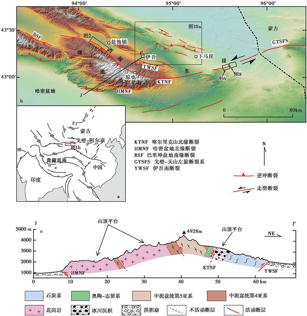
Fig. 1 Structural and geomorphological map around the Karlik Tagh at the easternmost Tian Shan.
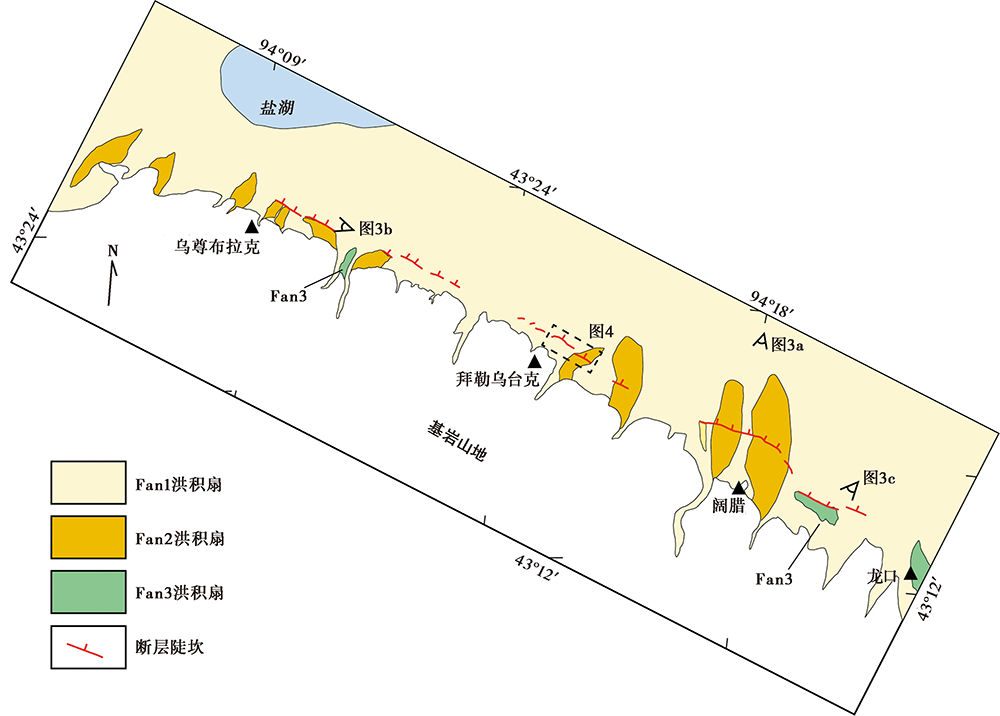
Fig. 2 Divisions of frontal morphologic units on east segment of the KTNF.
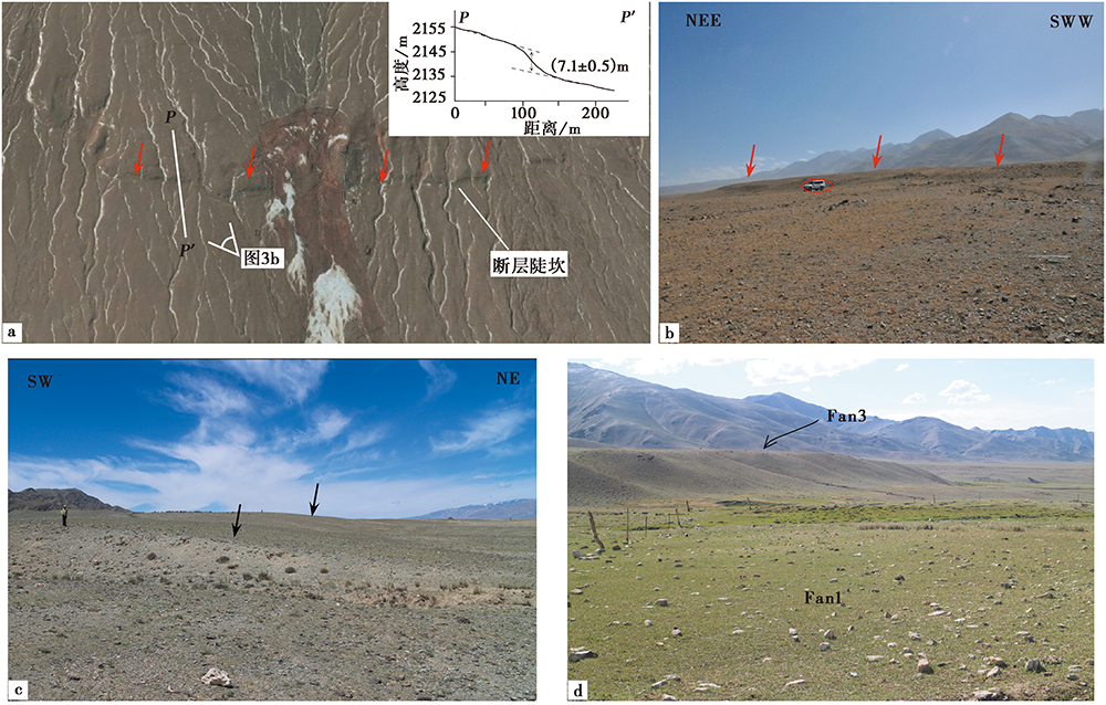
Fig. 3 Field photos of deformed Late Quateranry deposits along the west segment of KTNF.
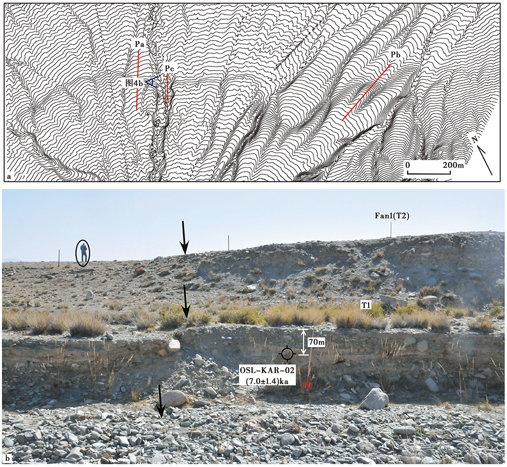
Fig. 4 The topography at Bileuteck site on west segment of KTNF(a); Photos of deformed terraces and sampling site(b).
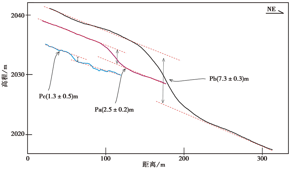
Fig. 5 Topographical profiles normal to the fault scarp at Bileuteck site(see Fig.4a for detailed site location).
| 编号 | 埋深 /m | 238U/Bg·kg-1 | 226Ra/Bg·kg-1 | 232Th/Bg·kg-1 | 40K/Bg·kg-1 | 含水量 /% | 环境剂量率 /Gy·ka-1 | 等效剂量 /Gy | 年龄 /ka |
|---|---|---|---|---|---|---|---|---|---|
| KAR-OSL-02 | 0.7 | 55.8±9.9 | 32.2±0.9 | 45.2±1.0 | 582.9±19.9 | 4 | 3.5±0.2 | 24.4±4.6 | 7.0±1.4 |
Table 1 The result of OSL dating from the T1 terrace on Bileuteck segment
| 编号 | 埋深 /m | 238U/Bg·kg-1 | 226Ra/Bg·kg-1 | 232Th/Bg·kg-1 | 40K/Bg·kg-1 | 含水量 /% | 环境剂量率 /Gy·ka-1 | 等效剂量 /Gy | 年龄 /ka |
|---|---|---|---|---|---|---|---|---|---|
| KAR-OSL-02 | 0.7 | 55.8±9.9 | 32.2±0.9 | 45.2±1.0 | 582.9±19.9 | 4 | 3.5±0.2 | 24.4±4.6 | 7.0±1.4 |
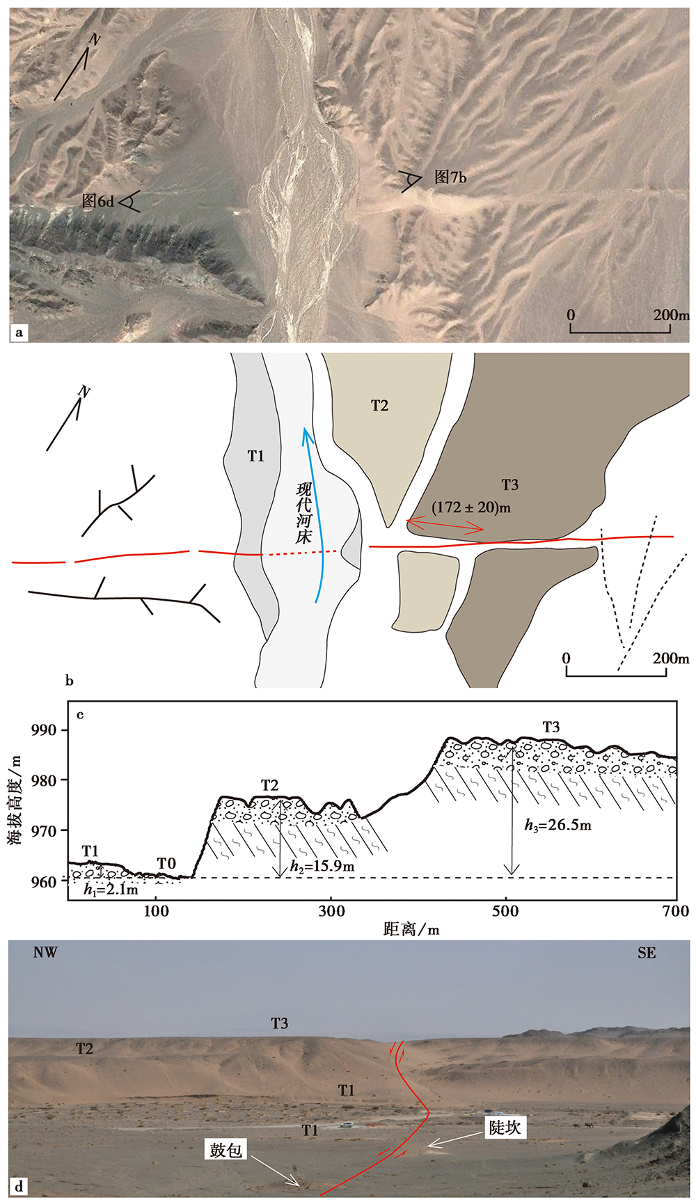
Fig. 6 Geomorphology of the faulted river terraces at the east segment of KTNF.
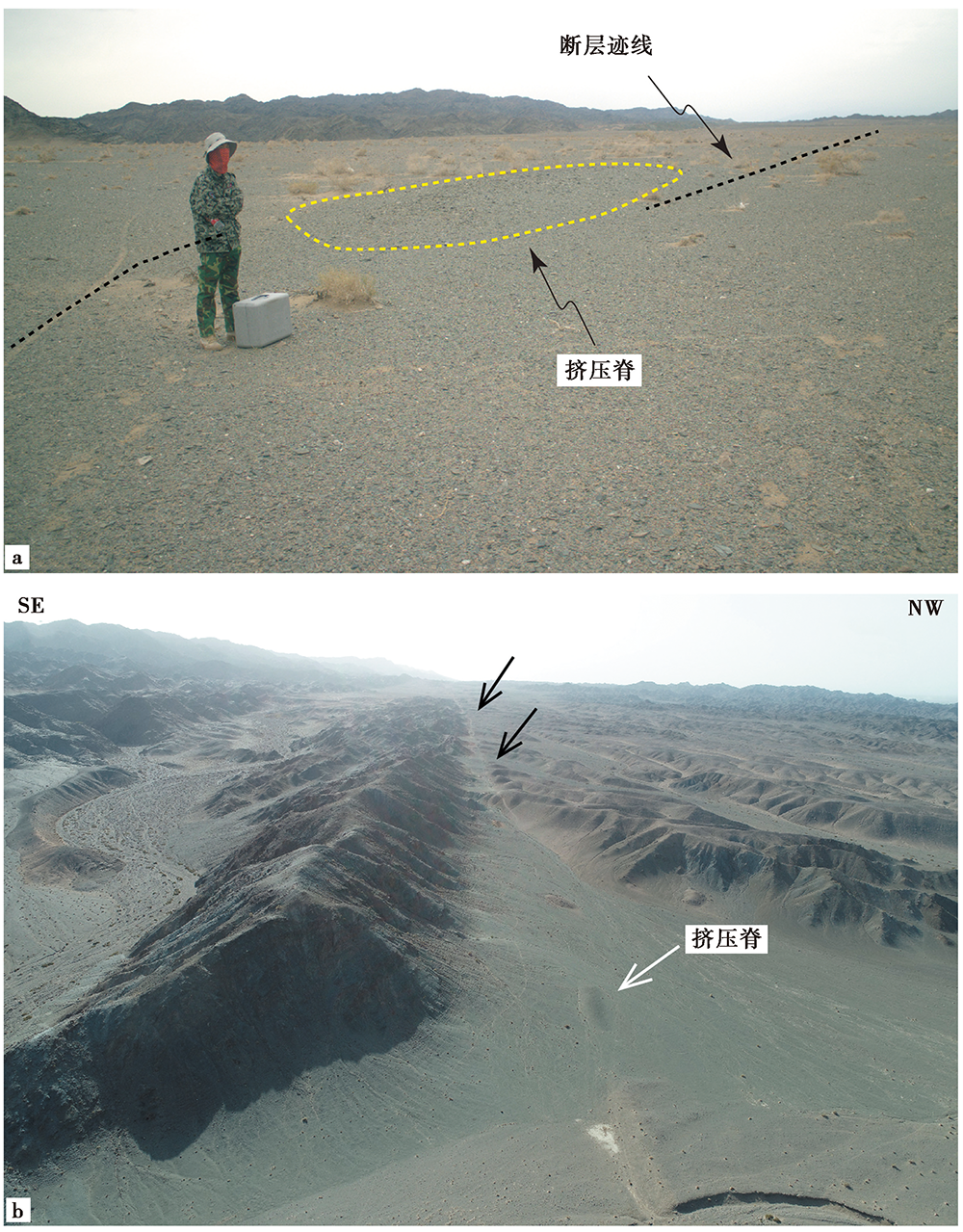
Fig. 7 Field photos of deformed landforms on east segment of KTNF.
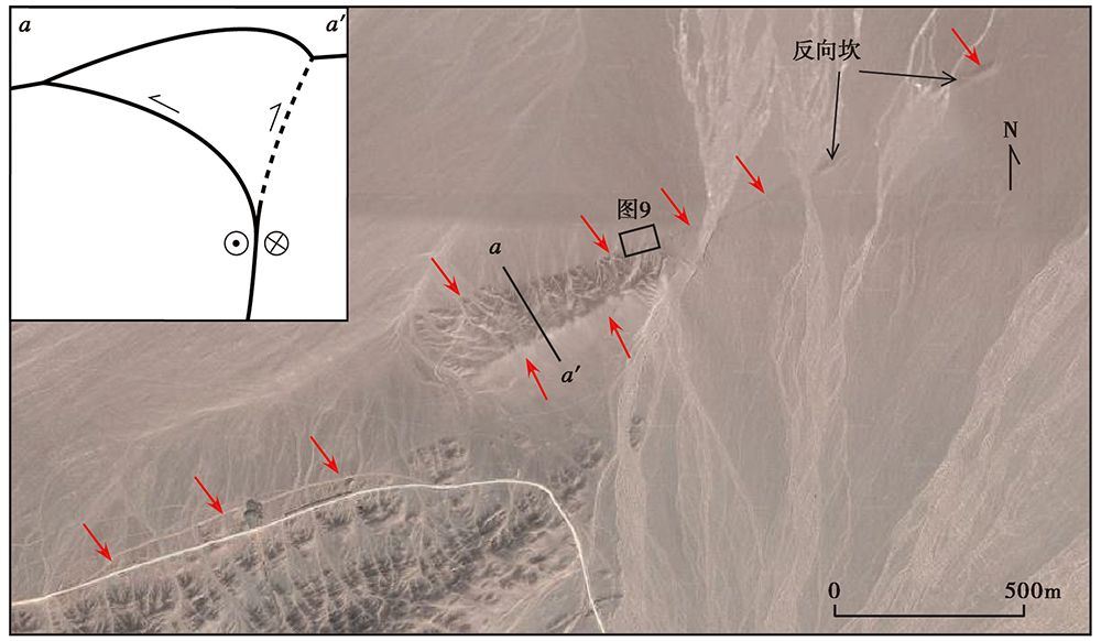
Fig. 8 Google Earth image of the uplifted massif at south of Xiamaya site.
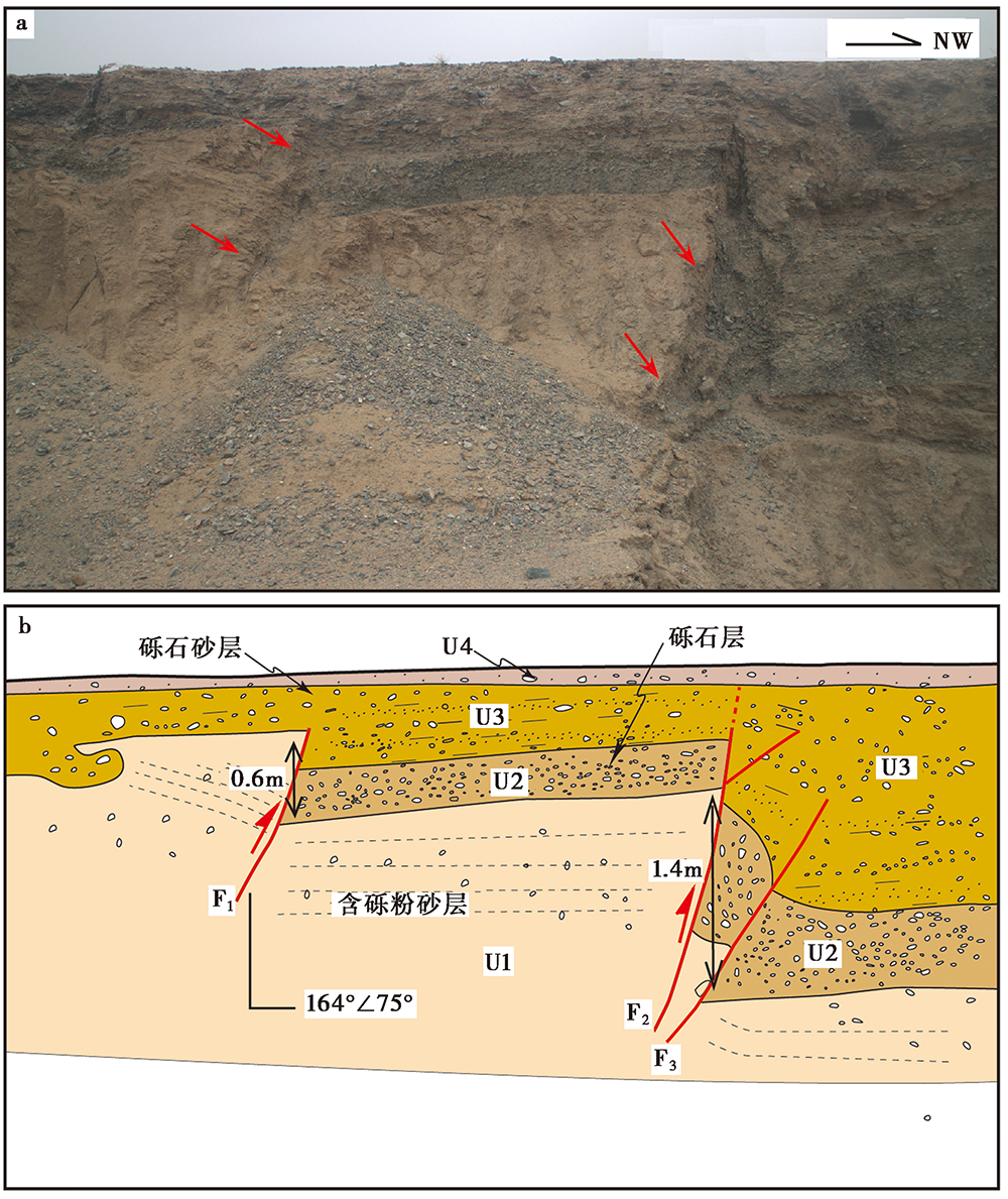
Fig. 9 Outcrop of the fault and its interpretation on east segment of KTNF.
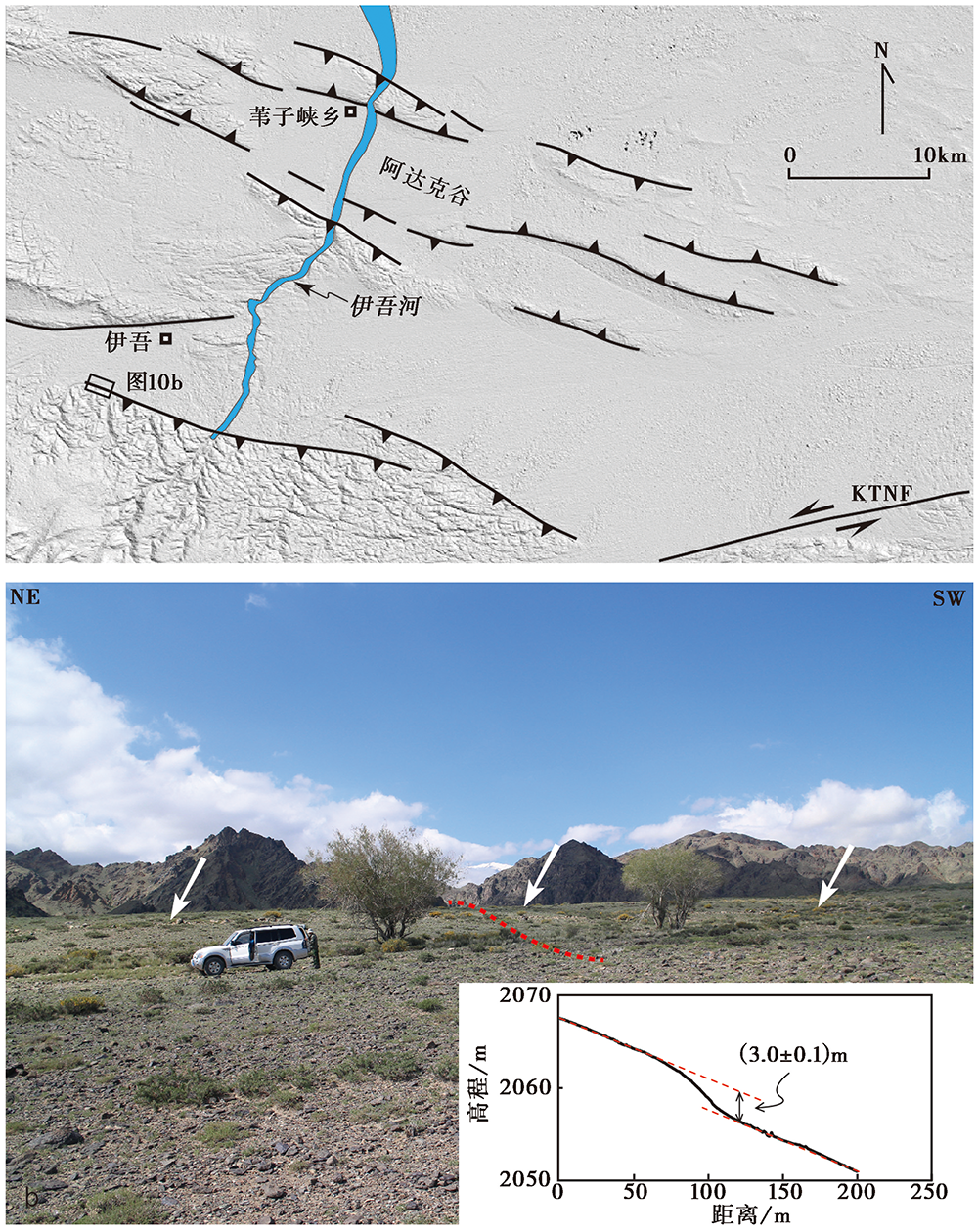
Fig. 10 Fault distribution around Yiwu and field photo.
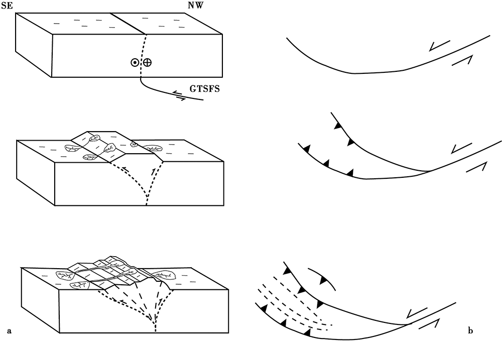
Fig. 11 Block diagrams representing the building process of Karlik Tagh(a) and corresponding stages in plain view(b).
| [1] | 柏美祥, 罗福忠, 李军, 等. 1999. 哈密盆地北缘活动断裂微地貌[J]. 内陆地震, 13(2): 162-168. |
| BO Mei-xiang, LUO Fu-zhong, LI Jun, et al. 1999. Micro-geomorphology on the active northern margin fault zone of Hami Basin[J]. Inland Earthquake, 13(2): 162-168. (in Chinese) | |
| [2] | 邓起东, 冯先岳, 张培震, 等. 2000. 天山活动构造[M]. 北京: 地震出版社. |
| DENG Qi-dong, FENG Xian-yue, ZHANG Pei-zhen, et al. 2000. Active Tectonics in Tianshan Mountains[M]. Seismological Press, Beijing. (in Chinese) | |
| [3] | 牛之俊, 游新兆, 杨少敏. 2007. 利用GPS分析天山现今地壳形变特征[J]. 大地测量与地球动力学, 27(2): 1-9. |
| NIU Zhi-jun, YOU Xin-zhao, YANG Shao-min. 2007. Analysis of contemporary crustal deformation characteristic with GPS data of Tianshan Mountains[J]. Journal of Geodesy and Geodynamics, 27(2): 1-9. (in Chinese) | |
| [4] | 沈传波, 梅廉夫, 刘麟, 等. 2006. 新疆博格达山中新生代隆升-热历史的裂变径迹记录[J]. 海洋地质与第四纪地质, 26(3): 87-92. |
| SHEN Chuan-bo, MEI Lian-fu, LIU Lin, et al. 2006. Evidence from apatite and zircon fission track analysis for Mesozoic-Cenozoic uplift thermal history of Bogda Mountain of Xinjiang, northwest China[J]. Marine Geology & Quaternary Geology, 26(3): 87-92. (in Chinese) | |
| [5] | 王琪, 丁国瑜, 乔学军, 等. 2000. 天山现今地壳快速缩短与南北地块的相对运动[J]. 科学通报, 45(14): 1543-1547. |
| WANG Qi, DING Guo-yu, QIAO Xue-jun, et al. 2000. Recent rapid shortening of crust across the Tianshan Mts. and relative motion of tectonic blocks in the north and south[J]. Chinese Science Bullutin, 45(14): 1543-1547. (in Chinese) | |
| [6] | 王宗秀, 李涛, 张进, 等. 2008. 博格达山链新生代抬升过程及意义[J]. 中国科学(D辑), 38(3): 312-326. |
| WANG Zong-xiu, LI Tao, ZHANG Jin, et al. 2008. The uplifting process of the Bogda Mountain during the Cenozoic and its tectonic implication[J]. Science in China(Ser D), 38(3): 312-326. (in Chinese) | |
| [7] | 吴富峣. 2016. 东天山东段几条主要断裂晚第四纪活动证据与变形机制[D]. 北京: 中国地震局地质研究所. |
| WU Fu-yao. 2016. Late Quaternary activity of several main faults in east section of eastern Tian Shan and its implication on regional deformation mechanism[D]. Institute of Geology, China Earthquake Administration, Beijing. (in Chinese) | |
| [8] | 吴富峣, 冉勇康, 陈立春, 等. 2016. 东天山3条地震地表破裂带的展布及其与2次历史地震的关系[J]. 地震地质, 38(1): 77-90. |
| WU Fu-yao, RAN Yong-kang, CHEN Li-chun, et al. 2016. Distribution of 3 earthquake rupture zones in eastern Tienshan and its relationship with 2 historical earthquakes[J]. Seismology and Geology, 38(1): 77-90. (in Chinese) | |
| [9] |
徐良鑫, 冉勇康, 梁明剑, 等. 2020. 新疆巴里坤1842年和1914年2次M7½历史地震地表破裂的几何展布及特征[J]. 地震地质, 42(1): 1-17. doi: 10.3969/j.issn.0253-4967.2020.01.001.
DOI |
| XU Liang-xin, RAN Yong-kang, LIANG Ming-jian, et al. 2020. Geometric distribution and characteristic of the surface rupture of two historical earthquakes in the Barkol Basin, Xinjiang[J]. Seismology and Geology, 42(1): 1-17. (in Chinese) | |
| [10] | 杨少敏, 李杰, 王琪. 2008. GPS研究天山现今变形与断层活动[J]. 中国科学(D辑), 38(7): 872-880. |
| YANG Shao-min, LI Jie, WANG Qi. 2008. The deformation pattern and fault rate in the Tianshan Mountains inferred from GPS observations[J]. Science in China(Ser D), 38(7): 872-880. (in Chinese) | |
| [11] | 张培震, 邓起东, 杨晓平, 等. 1996. 天山的晚新生代构造变形及其地球动力学问题[J]. 中国地震, 12(2): 127-140. |
| ZHANG Pei-zhen, DENG Qi-dong, YANG Xiao-ping, et al. 1996. Late Cenozoic tectonic deformation and mechanism along the Tianshan Mountains, northwestern China[J]. Earthquake Research in China, 12(2): 127-140. (in Chinese) | |
| [12] | 朱自虎, 季建清, 徐芹芹, 等. 2010. 新疆博格达-哈尔里克山晚新生代转换挤压性变形与隆起成山[J]. 地质科学, 45(3): 653-665. |
| ZHU Zi-hu, JI Jian-qing, XU Qin-qin, et al. 2010. The Late Cenozoic transpressional deformation and uplift of Bogda-Harlic Mountains[J]. Chinese Journal of Geology, 45(3): 653-665. (in Chinese) | |
| [13] |
Bande A, Sobel E R, Mikolaichuk A, et al. 2015. Talas-Fergana Fault Cenozoic timing of deformation and its relation to Pamir indentation[J]. Geological Society, London, Special Publications, 427(1): 295-311.
DOI URL |
| [14] | Biddle K T, Christie B N. 1985. Glossary-strike-slip deformation, basin formation and sedimentation[J]. SEPM. Special Publication, 68(4): 375-384. |
| [15] | Calais E, Vergnolle M, San’kov V, et al. 2003. GPS measurements of crustal deformation in the Baikal-Mongolia area(1994-2002): Implications for current kinematics of Asia[J]. Journal of Geophysical Research: Solid Earth, 108(B10): ETG14-1-ETG14-13. |
| [16] |
Cunningham D. 2005. Active intracontinental transpressional mountain building in the Mongolia Altai: Defining a new class of orogeny[J]. Earth and Planetary Science Letters, 240(2): 436-444.
DOI URL |
| [17] |
Cunningham D, Mann P. 2007. Tectonics of strike-slip restraining and releasing bends[J]. Geological Society, London, Special Publications, 290(1): 1-12.
DOI URL |
| [18] |
Cunningham D, Owen L A, Snee L, et al. 2003. Structural framework of a major intracontinental orogenic termination zone: The easternmost Tienshan, China[J]. Journal of Geological Society, 160(4): 575-590.
DOI URL |
| [19] |
Cunningham D, Windley B, Dorjnamjaa D, et al. 1996. Late Cenozoic transpression in southwestern Mongolia and the Gobi Altai-Tien Shan connection[J]. Earth and Planetary Science Letters, 140(1-4): 67-81.
DOI URL |
| [20] |
Dewey J F, Holdsworth R E, Strachan R A. 1998. Transpression and transtension zones[J]. Geological Society, London, Special publications, 135(1): 1-14.
DOI URL |
| [21] | Gu L X, Hu S X, Chu Q. 1999. Pre-collision granites and post-collision intrusive assemblage of the Kelameili-Harlik orogenic belt[J]. Acta Geological Sinica, 73(3): 316-329. |
| [22] |
Harland W B. 1971. Tectonic transpression in Caledonian Spisbergen[J]. Geological Magazine, 108(1): 27-41.
DOI URL |
| [23] |
Hendrix M S, Dumitru T A, Graham S A. 1994. Late Oligocene-early Miocene unroofing in the Chinese Tianshan: An early effect of the India-Asia collision[J]. Geology, 22(6): 487-490.
DOI URL |
| [24] | Jia Y, Fu B, Jolivet M, et al. 2015. Cenozoic tectono-geomorphological growth of the SW Chinese Tian Shan: Insight from AFT and detrital zircon U-Pb data[J]. Journal of Asia Earth Science, 111(1): 395-413. |
| [25] |
Molnar P, Deng Q D. 1984. Faulting associated with large earthquakes and the average rate of deformation in central and eastern Asia[J]. Journal of Geophysical Research, 89(B7): 6203-6227.
DOI URL |
| [26] |
Shu L S, Charvet J, Lu H F, et al. 2002. Paleozoic accretion-collision events and kinematics of ductile deformation in the eastern part of the southern-central Tianshan belt, China[J]. Acta Geologica Sinica, 76(3): 308-323.
DOI URL |
| [27] | Thompson S C, Weldon R J, Rubin C M, et al. 2002. Late Quaternary slip rates across the central Tien Shan, Kyrgyzstan, Central Asia[J]. Journal of Geophysical Research, 107(B9): ETG7-1-ETG7-32. |
| [28] | Vassallo R, Ritz J F, Bruacher R, et al. 2007. Transpressional tectonics and stream terraces of the Gobi-Altai, Mongolia[J]. Tectonics, 26(5): 1-8. |
| [29] | Zoback M L. 1992. Frist- and second-order patterns of stress in the lithosphere: The world stress map project[J]. Journal of Geophysical Research: Solid Earth, 97(B8): 11703-11728. |
| [30] | Zubovich A V, Wang X Q, Scherba Y G, et al. 2010. GPS velocity field for the Tien Shan and surrounding regions[J]. Tectonics, 29(6): 250-272. |
| [1] | YANG Chen-yi, LI Xiao-ni, FENG Xi-jie, HUANG Yin-di, PEI Gen-di. SHALLOW STRUCTURE AND QUATERNARY ACTIVITY OF THE TAOCHUAN-HUXIAN FAULT, THE SUB-STRAND OF THE NORTHERN QINLING FAULT ZONE [J]. SEISMOLOGY AND GEOLOGY, 2023, 45(2): 464-483. |
| [2] | LI Yi-shi. RESEARCH ON COMPREHENSIVE STANDARDIZATION FOR SURVEYING AND PROSPECTING OF ACTIVE FAULT [J]. SEISMOLOGY AND GEOLOGY, 2023, 45(2): 455-463. |
| [3] | ZHANG Ling, MIAO Shu-qing, YANG Xiao-ping. THE ANALYSIS AND IMPLEMENTATION OF THE AUTOMATIC EXTRACTING METHOD FOR ACTIVE THRUST FAULTS IN THE NORTH TIANSHAN MOUNTAINS BASED ON ARCGIS SOFTWARE PLATFORM [J]. SEISMOLOGY AND GEOLOGY, 2023, 45(2): 422-434. |
| [4] | JIANG Feng-yun, JI Ling-yun, ZHU Liang-yu, LIU Chuan-jin. THE PRESENT CRUSTAL DEFORMATION CHARACTERISTICS OF THE HAIYUAN-LIUPANSHAN FAULT ZONE FROM INSAR AND GPS OBSERVATIONS [J]. SEISMOLOGY AND GEOLOGY, 2023, 45(2): 377-400. |
| [5] | WANG Liao, XIE Hong, YUAN Dao-yang, LI Zhi-min, XUE Shan-yu, SU Rui-huan, WEN Ya-meng, SU Qi. THE SURFACE RUPTURE CHARACTERISTICS BASED ON THE GF-7 IMAGES INTERPRETATION AND THE FIELD INVESTIGA-TION OF THE 2022 MENYUAN MS6.9 EARTHQUAKE [J]. SEISMOLOGY AND GEOLOGY, 2023, 45(2): 401-421. |
| [6] | LIU Qing, LIU Shao, ZHANG Shi-min. PALEOSEISMOLOGIC STUDY ON THE YUEXI FAULT IN THE MIDSECTION OF THE DALIANGSHAN FAULT ZONE SINCE THE LATE QUATERNARY [J]. SEISMOLOGY AND GEOLOGY, 2023, 45(2): 321-337. |
| [7] | ZHAO Peng, LI Jun-hui, TAO Yue-chao, SHU Peng, FANG Zhen. NEW ACTIVITY PHENOMENA REVEALED BY TRENCH ON THE NORTH SIDE OF NÜSHAN LAKE IN THE TANLU FAULT ZONE AND DISCUSSION [J]. SEISMOLOGY AND GEOLOGY, 2023, 45(2): 338-354. |
| [8] | ZUO Yu-qi, YANG Hai-bo, YANG Xiao-ping, ZHAN Yan, LI An, SUN Xiang-yu, HU Zong-kai. EVIDENCE OF LATE QUATERNARY TECTONIC ACTIVITY OF THE BEIDA SHAN FAULT, SOUTHERN MARGIN OF THE ALASHAN BLOCK [J]. SEISMOLOGY AND GEOLOGY, 2023, 45(2): 355-376. |
| [9] | LI Xiao-ni, YANG Chen-yi, LI Gao-yang, FENG Xi-jie, HUANG Yin-di, LI Chen-xia, LI Miao, PEI Gen-di, WANG Wan-he. SHALLOW STRUCTURE AND LATE QUATERNARY ACTIVITIES OF BRANCH FAULTS ON THE NORTHERN SIDE OF THE WEINAN TABLELAND IN THE SOUTHEASTERN MARGIN OF THE WEIHE BASIN [J]. SEISMOLOGY AND GEOLOGY, 2023, 45(2): 484-499. |
| [10] | LIU Bai-yun, ZHAO Li, LIU Yun-yun, WANG Wen-cai, ZHANG Wei-dong. THE RESEARCH ON RELOCATION AND FAULT PLANE SOLUTION AND GEOMETRIC MEANING OF THE MADUO M7.4 EARTHQUAKE ON 22 MAY 2021 [J]. SEISMOLOGY AND GEOLOGY, 2023, 45(2): 500-516. |
| [11] | ZHAO De-zheng, QU Chun-yan, ZHANG Gui-fang, GONG Wen-yu, SHAN Xin-jian, ZHU Chuan-hua, ZHANG Guo-hong, SONG Xiao-gang. APPLICATIONS AND ADVANCES FOR THE COSEISMIC DEFORMA-TION OBSERVATIONS, EARTHQUAKE EMERGENCY RESPONSE AND SEISMOGENIC STRUCTURE INVESTIGATION USING INSAR [J]. SEISMOLOGY AND GEOLOGY, 2023, 45(2): 570-592. |
| [12] | LI An, WAN Bo, WANG Xiao-xian, JI Hao-min, SUO Rui. NEW EVIDENCE OF THE PALEOEARTHQUAKE RUPTURE IN THE NORTH GAIZHOU-ANSHAN SEGMENT OF THE JINZHOU FAULT [J]. SEISMOLOGY AND GEOLOGY, 2023, 45(1): 111-126. |
| [13] | ZHENG Hai-gang, YAO Da-quan, ZHAO Peng, YANG Yuan-yuan, HUANG Jin-shui. NEW ACTIVITY CHARACTERISTICS IN THE CHISHAN SECTION OF TAN-LU FAULT ZONE IN HOLOCENE [J]. SEISMOLOGY AND GEOLOGY, 2023, 45(1): 127-138. |
| [14] | TIAN Yi-ming, YANG Zhuo-xin, WANG Zhi-shuo, SHI Jin-hu, ZHANG Yang, TAN Ya-li, ZHANG Jian-zhi, SONG Wei, JI Tong-yu. A PRELIMINARY STUDY OF THE SHALLOW EXPLORATION AND QUATERNARY ACTIVITIES OF THE FENGQIU SEGMENT OF THE XINXIANG-SHANGQIU FAULT [J]. SEISMOLOGY AND GEOLOGY, 2023, 45(1): 139-152. |
| [15] | YANG Jian-wen, JIN Ming-pei, CHA Wen-jian, ZHANG Tian-ji, YE Beng. CRUSTAL S-WAVE VELOCITY STRUCTURE BENEATH THE XIAO-JIANG FAULT ZONE AND ADJACENT REGIONS REVEALED BY TWO-STEP INVERSION METHOD OF RECEIVER FUNCTIONS [J]. SEISMOLOGY AND GEOLOGY, 2023, 45(1): 190-207. |
| Viewed | ||||||
|
Full text |
|
|||||
|
Abstract |
|
|||||
Copyright © SEISMOLOGY AND GEOLOGY, All Rights Reserved.
Tel: 010-62009049/9063 E-mail: dzdz@ies.ac.cn
Powered by Beijing Magtech Co., Ltd.