
SEISMOLOGY AND GEOLOGY ›› 2026, Vol. 48 ›› Issue (1): 43-63.DOI: 10.3969/j.issn.0253-4967.20240051
• Research pape • Previous Articles Next Articles
CHARACTERISTICS OF VERTICAL SLIP RATE EVOLUTION ALONG THE JIAOCHENG FAULT ZONE, SHANXI, SINCE LATE PLEISTOCENE
LUO Jia-xin1)( ), LI Bin1,3),*(), LI Zi-hong2,4), FAN Kun1)
- 1)
College of Geological and Surveying Engineering ,Taiyuan University of Technology
2)Shanxi Earthquake Agency
3)Institute of Prevention for Earthquake and Geology Hazards ,Taiyuan University of Technology
4)Shanxi Taiyuan National Continental Rift Valley Dynamics National Observation and Research Station ,Shanxi
-
Received:2025-04-16Revised:2025-08-01Online:2026-02-20Published:2026-03-14
晚更新世以来山西交城断裂带垂向活动速率演化特征
罗嘉鑫1)(), 李斌1,3),*(), 李自红2,4), 范琨1)
- 1)
太原理工大学
2)山西省地震局
3)太原理工大学
4)太原大陆裂谷动力学国家野外科学观测研究站
-
通讯作者:* 李斌, 男, 1980年生, 博士, 副教授, 硕士生导师, 主要从事地震地质与地震学方面的研究, E-mail: John.bli@hotmail.com。 -
作者简介:罗嘉鑫, 男, 1999年生, 太原理工大学地质资源与地质工程专业在读硕士研究生, 主要从事活动构造与地震灾害方面研究, E-mail: Luojiaxin990@163.com。
-
基金资助:山西太原大陆裂谷动力学国家野外科学观测研究站课题(NORSTY2023-01); 国家自然科学基金(41504051); 山西省基础研究计划(202303021211037); 山西省重点研发计划(202202020101009)
Cite this article
LUO Jia-xin, LI Bin, LI Zi-hong, FAN Kun. CHARACTERISTICS OF VERTICAL SLIP RATE EVOLUTION ALONG THE JIAOCHENG FAULT ZONE, SHANXI, SINCE LATE PLEISTOCENE[J]. SEISMOLOGY AND GEOLOGY, 2026, 48(1): 43-63.
罗嘉鑫, 李斌, 李自红, 范琨. 晚更新世以来山西交城断裂带垂向活动速率演化特征[J]. 地震地质, 2026, 48(1): 43-63.
share this article
Add to citation manager EndNote|Ris|BibTeX
URL: https://www.dzdz.ac.cn/EN/10.3969/j.issn.0253-4967.20240051

Fig. 1 Regional tectonic setting and fault distribution of the Jiaocheng fault zone area.
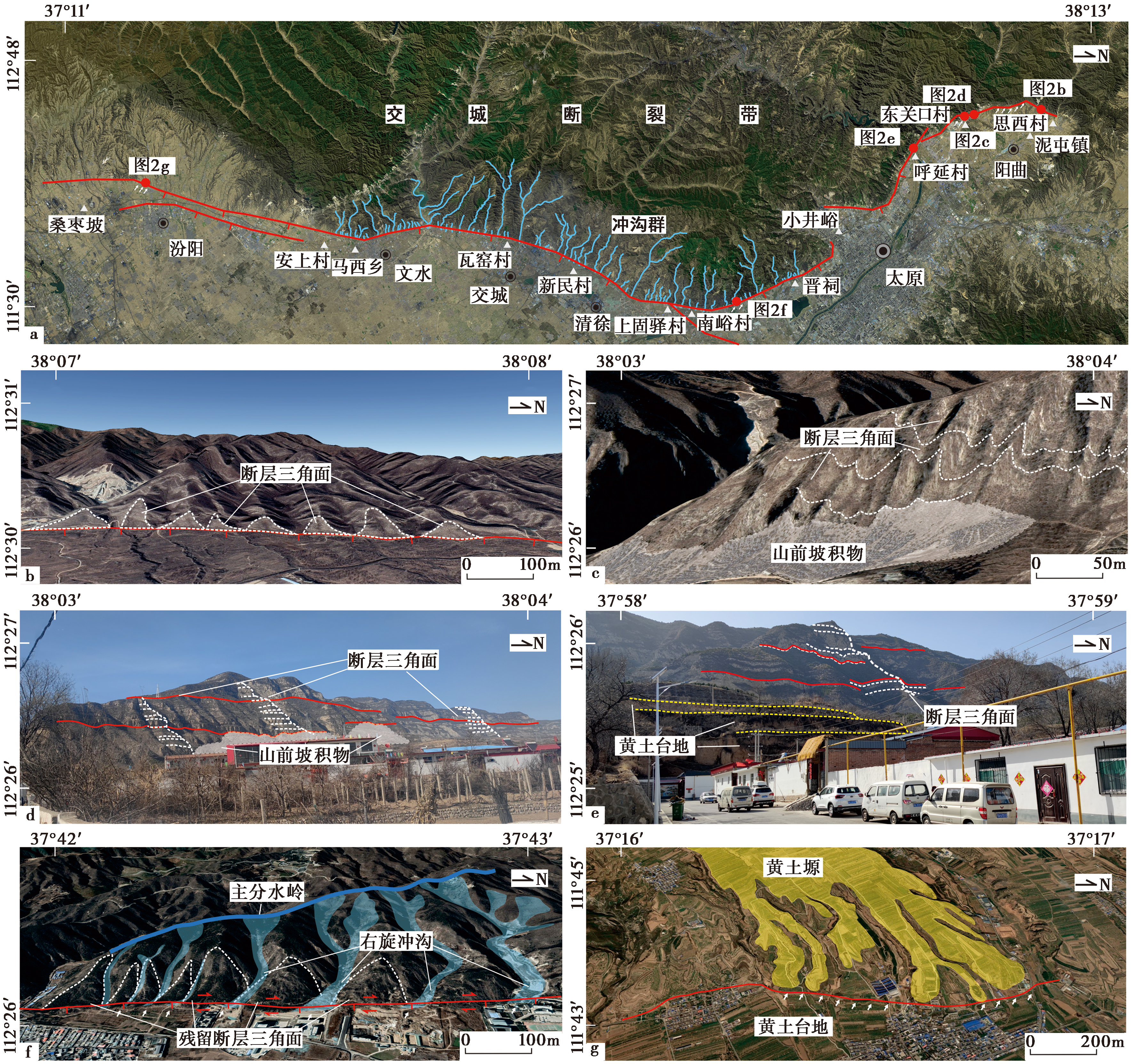
Fig. 2 Typical tectonic geomorphologies along the Jiaocheng fault zone.
| 所处 分段 | 测点位置 | 构造地貌标志 | 活动时期 | 平均活动速率 /mm·a-1 | 核算时期 | 核算时间 /ka | 核算速率 /mm·a-1 | 数据来源 |
|---|---|---|---|---|---|---|---|---|
| 上兰段 | 呼延村 | 断层剖面 | 中更新世以来 | 约0.55 | 中更新世以来 | 190.17±19.1 | 约0.53 | 许桂林等, |
| 太原西北 | 黄土台地 | 晚更新世以来 | 约0.86 | 晚更新世以来 | 约122 | 0.82~0.90 | 马保起等, | |
| 思西村 | 基岩断层坎 | 全新世 | 0.63~0.64 | 全新世以来 | 8.36~8.56 | 0.63~0.64 | Zou et al., | |
| 上兰镇 | 基岩断层坎 | 全新世 | 0.64~0.67 | 全新世以来 | 8.36~8.56 | 0.64~0.67 | Zou et al., | |
| 晋祠段 | 牛家口沟 | 阶地剖面 | 晚更新世以来 | >1.07 | 晚更新世以来 | 16.87±1.42 | 0.98~1.17 | 许桂林等, |
| 南峪村 | 阶地剖面 | 全新世 | 0.38~0.45 | 全新世以来 | 7.34±0.62 | 0.38~0.45 | 江娃利等, | |
| 清徐—文水段 | 清徐—交城 | 湖相层顶面 和断距 | 中更新世以来 | 0.38 | 中更新世以来 | 700 | 0.38 | 王乃樑等, |
| 文水南武 | 湖相层顶面 和断距 | 中更新世以来 | 0.29 | 中更新世以来 | 700 | 0.29 | 王乃樑等, | |
| 白石沟 | 阶地剖面 | 晚更新世以来 | 0.92~1.10 | 晚更新世以来 | 19.96±1.70 | 0.92~1.10 | 江娃利等, | |
| 西梁泉 | 黄土台地 | 晚更新世以来 | 0.87 | 晚更新世以来 | 17.66 | 0.87 | 江娃利等, | |
| 耙齿沟 | 阶地剖面 | 晚更新世以来 | 0.78~0.93 | 晚更新世以来 | 23.57±2.00 | 0.78~0.93 | 江娃利等, | |
| 耙齿沟 | 阶地剖面 | 晚更新世以来 | 0.51~0.61 | 晚更新世以来 | 62.86±5.34 | 0.51~0.61 | 江娃利等, | |
| 磁窑沟 | 阶地剖面 | 晚更新世以来 | 0.62~0.74 | 晚更新世以来 | 51.80±4.40 | 0.62~0.74 | 江娃利等, | |
| 磁窑沟 | 阶地剖面 | 晚更新世以来 | 0.56~0.66 | 晚更新世以来 | 58.04±4.93 | 0.56~0.66 | 江娃利等, | |
| 瓦窑西 | 黄土台地 | 晚更新世以来 | >(1.15~1.34) | 晚更新世以来 | 52.54±10.42 | 0.95~1.66 | 许桂林等, | |
| 瓦窑西 | 黄土台地 | 晚更新世以来 | 1.4~1.5 | 晚更新世以来 | 约52 | 1.35~1.54 | 马保起等, | |
| 石壁沟 | 阶地剖面 | 晚更新世以来 | 0.82~0.97 | 晚更新世以来 | 28.68±2.44 | 0.82~0.97 | 江娃利等, | |
| 洪相村 | 阶地剖面 | 晚更新世以来 | >0.82 | 晚更新世以来 | <61.15 | >0.82 | 江娃利等, | |
| 洪相村 | 阶地剖面 | 晚更新世以来 | 0.52 | 晚更新世以来 | 16.28~16.55 | 0.51~0.52 | 江娃利等, | |
| 文峪河 | 阶地剖面 | 晚更新世以来 | 0.89~1.05 | 晚更新世以来 | 25.99±2.21 | 0.89~1.05 | 江娃利等, | |
| 西梁泉 | 黄土台地 | 全新世 | 0.79 | 全新世以来 | 10.70 | 0.79 | 江娃利等, | |
| 大峪沟 | 洪积扇陡坎 | 全新世 | 1.1~1.4 | 全新世以来 | 6.97 | 0.72~1.15 | 马保起等, | |
| 市儿口沟 | 洪积扇陡坎 | 全新世 | 全新世以来 | 5.81 | 约1.38 | 马保起等, | ||
| 市儿口沟和 瓦窑沟 | 阶地剖面 | 全新世 | 1.24 | 全新世以来 | 9~10 | 1.20~1.33 | 马保起等, | |
| 市儿口沟 | 洪积扇陡坎 | 全新世 | <1.3 | 全新世以来 | 5.81±0.63 | 1.09~1.54 | 许桂林等, | |
| 胡并石沟 | 阶地剖面 | 全新世 | 1.11~1.31 | 全新世以来 | 11.83±1.01 | 1.11~1.31 | 江娃利等, | |
| 沟口村 | 阶地剖面 | 全新世 | 0.73~0.87 | 全新世以来 | 12.6±1.07 | 0.73~0.87 | 江娃利等, | |
| 汾阳段 | 杏花村 | 湖相层顶面 和断距 | 中更新世以来 | 0.43 | 晚更新世以来 | 700 | 约0.43 | 王乃樑等, |
Table1 Vertical slip rates of various tectonic geomorphology survey points in the Jiaocheng fault zone
| 所处 分段 | 测点位置 | 构造地貌标志 | 活动时期 | 平均活动速率 /mm·a-1 | 核算时期 | 核算时间 /ka | 核算速率 /mm·a-1 | 数据来源 |
|---|---|---|---|---|---|---|---|---|
| 上兰段 | 呼延村 | 断层剖面 | 中更新世以来 | 约0.55 | 中更新世以来 | 190.17±19.1 | 约0.53 | 许桂林等, |
| 太原西北 | 黄土台地 | 晚更新世以来 | 约0.86 | 晚更新世以来 | 约122 | 0.82~0.90 | 马保起等, | |
| 思西村 | 基岩断层坎 | 全新世 | 0.63~0.64 | 全新世以来 | 8.36~8.56 | 0.63~0.64 | Zou et al., | |
| 上兰镇 | 基岩断层坎 | 全新世 | 0.64~0.67 | 全新世以来 | 8.36~8.56 | 0.64~0.67 | Zou et al., | |
| 晋祠段 | 牛家口沟 | 阶地剖面 | 晚更新世以来 | >1.07 | 晚更新世以来 | 16.87±1.42 | 0.98~1.17 | 许桂林等, |
| 南峪村 | 阶地剖面 | 全新世 | 0.38~0.45 | 全新世以来 | 7.34±0.62 | 0.38~0.45 | 江娃利等, | |
| 清徐—文水段 | 清徐—交城 | 湖相层顶面 和断距 | 中更新世以来 | 0.38 | 中更新世以来 | 700 | 0.38 | 王乃樑等, |
| 文水南武 | 湖相层顶面 和断距 | 中更新世以来 | 0.29 | 中更新世以来 | 700 | 0.29 | 王乃樑等, | |
| 白石沟 | 阶地剖面 | 晚更新世以来 | 0.92~1.10 | 晚更新世以来 | 19.96±1.70 | 0.92~1.10 | 江娃利等, | |
| 西梁泉 | 黄土台地 | 晚更新世以来 | 0.87 | 晚更新世以来 | 17.66 | 0.87 | 江娃利等, | |
| 耙齿沟 | 阶地剖面 | 晚更新世以来 | 0.78~0.93 | 晚更新世以来 | 23.57±2.00 | 0.78~0.93 | 江娃利等, | |
| 耙齿沟 | 阶地剖面 | 晚更新世以来 | 0.51~0.61 | 晚更新世以来 | 62.86±5.34 | 0.51~0.61 | 江娃利等, | |
| 磁窑沟 | 阶地剖面 | 晚更新世以来 | 0.62~0.74 | 晚更新世以来 | 51.80±4.40 | 0.62~0.74 | 江娃利等, | |
| 磁窑沟 | 阶地剖面 | 晚更新世以来 | 0.56~0.66 | 晚更新世以来 | 58.04±4.93 | 0.56~0.66 | 江娃利等, | |
| 瓦窑西 | 黄土台地 | 晚更新世以来 | >(1.15~1.34) | 晚更新世以来 | 52.54±10.42 | 0.95~1.66 | 许桂林等, | |
| 瓦窑西 | 黄土台地 | 晚更新世以来 | 1.4~1.5 | 晚更新世以来 | 约52 | 1.35~1.54 | 马保起等, | |
| 石壁沟 | 阶地剖面 | 晚更新世以来 | 0.82~0.97 | 晚更新世以来 | 28.68±2.44 | 0.82~0.97 | 江娃利等, | |
| 洪相村 | 阶地剖面 | 晚更新世以来 | >0.82 | 晚更新世以来 | <61.15 | >0.82 | 江娃利等, | |
| 洪相村 | 阶地剖面 | 晚更新世以来 | 0.52 | 晚更新世以来 | 16.28~16.55 | 0.51~0.52 | 江娃利等, | |
| 文峪河 | 阶地剖面 | 晚更新世以来 | 0.89~1.05 | 晚更新世以来 | 25.99±2.21 | 0.89~1.05 | 江娃利等, | |
| 西梁泉 | 黄土台地 | 全新世 | 0.79 | 全新世以来 | 10.70 | 0.79 | 江娃利等, | |
| 大峪沟 | 洪积扇陡坎 | 全新世 | 1.1~1.4 | 全新世以来 | 6.97 | 0.72~1.15 | 马保起等, | |
| 市儿口沟 | 洪积扇陡坎 | 全新世 | 全新世以来 | 5.81 | 约1.38 | 马保起等, | ||
| 市儿口沟和 瓦窑沟 | 阶地剖面 | 全新世 | 1.24 | 全新世以来 | 9~10 | 1.20~1.33 | 马保起等, | |
| 市儿口沟 | 洪积扇陡坎 | 全新世 | <1.3 | 全新世以来 | 5.81±0.63 | 1.09~1.54 | 许桂林等, | |
| 胡并石沟 | 阶地剖面 | 全新世 | 1.11~1.31 | 全新世以来 | 11.83±1.01 | 1.11~1.31 | 江娃利等, | |
| 沟口村 | 阶地剖面 | 全新世 | 0.73~0.87 | 全新世以来 | 12.6±1.07 | 0.73~0.87 | 江娃利等, | |
| 汾阳段 | 杏花村 | 湖相层顶面 和断距 | 中更新世以来 | 0.43 | 晚更新世以来 | 700 | 约0.43 | 王乃樑等, |
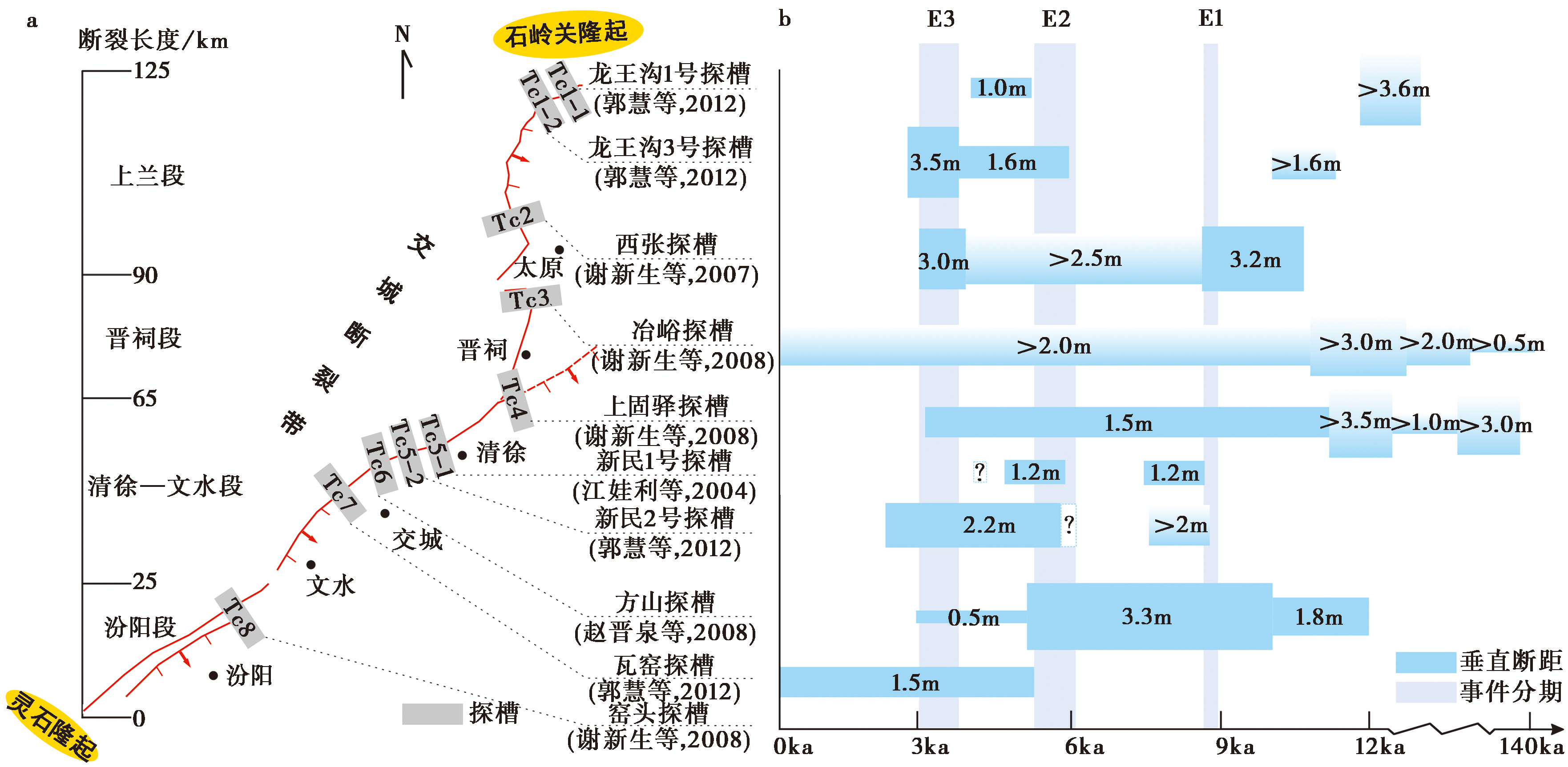
Fig. 3 Excavation of trenches along the Jiaocheng fault zone and the revealed paleo-earthquake events.
| 所处 分段 | 探槽 名称 | 探槽 地点 | 垂直断距 /m | 事件发生 时间/ka | 核算 断距 /m | 核算 起始时间 /ka | 核算 终止时间 /ka | 核算 活动速率 /mm·a-1 | 数据 来源 |
|---|---|---|---|---|---|---|---|---|---|
| 上兰段 | 龙王沟 1号探槽 | 阳曲县 泥屯小 盆地 西界 | >3.6 | 约15.56 | 约4.6 | 15.56 | 至今 | 约0.30 | 郭慧等, |
| 1.0 | 约4.98 | 1.0 | 4.98 | 至今 | 约0.20 | ||||
| 龙王沟 3号探槽 | >1.6 | 约10.77 | 约6.7 | 8.36~8.56 | 至今 | 0.78~0.80 | |||
| 1.6 | <5.69 | ||||||||
| 3.5 | 2.91~3.53 | ||||||||
西张探槽 | 太原市 柴村镇 西张村北 | 3.2 | 8.35~10.66 | 约8.7 | 8.36~8.56 | 至今 | 1.02~1.04 | 谢新生等, | |
| >2.5 | 3.74~8.35 | ||||||||
| 3.0 | 3.06~3.74 | ||||||||
| 晋祠段 | 冶峪探槽 | 太原市 金胜镇 冶峪村 | >0.5 | 109.22~134.52 | 约7.5 | 134.52 | 至今 | 约0.06 | 谢新生等, |
| >2.0 | 95.09~109.22 | ||||||||
| >3.0 | <95.09 | ||||||||
| >2.0 | <10.73 | 约2.0 | 8.36~8.56 | 至今 | 0.23~0.24 | ||||
上固驿探槽 | 清徐县 上固驿村 | >3.0 | 29.76~64.52 | 约9.0 | 29.76~64.52 | 至今 | 0.14~0.30 | ||
| >1.0 | <31.25 | ||||||||
| >3.5 | <21.21 | ||||||||
| 1.5 | 3.19~11.57 | 1.5 | 8.36~8.56 | 至今 | 约0.18 | ||||
| 清徐— 文水段 | 新民1号 探槽 | 清徐县 新民村 市儿口沟 西侧 | 1.2 | 约8.36 | 2.4 | 8.36~8.56 | 3.06~3.53 | 0.44~0.50 | 江娃利等, |
| 1.2 | 约5.91 | ||||||||
新民2号 探槽 | >2.0 | 约8.63 | 约2.0 | 8.36~8.56 | 5.32~6.14 | 0.62~0.90 | 郭慧等, | ||
| ? | <6.14 | ? | ? | ? | ? | ||||
| 2.2 | 2.37~6.00 | 2.2 | 3.06~3.53 | 至今 | 0.62~0.72 | ||||
方山探槽 | 清徐县北 | 1.8 | 10~12 | 约5.6 | 10~12 | 至今 | 0.47~0.56 | 赵晋泉等, | |
| 3.3 | >5 | ||||||||
| 0.5 | >3 | ||||||||
| 瓦窑探槽 | 交城县 瓦窑村东北 | 1.5 | <5.32 | 1.5 | 5.32~6.14 | 3.06~3.53 | 0.49~0.84 | 郭慧等, |
Table2 Vertical slip rates revealed by excavation and exploration of trenches along the Jiaocheng fault zone
| 所处 分段 | 探槽 名称 | 探槽 地点 | 垂直断距 /m | 事件发生 时间/ka | 核算 断距 /m | 核算 起始时间 /ka | 核算 终止时间 /ka | 核算 活动速率 /mm·a-1 | 数据 来源 |
|---|---|---|---|---|---|---|---|---|---|
| 上兰段 | 龙王沟 1号探槽 | 阳曲县 泥屯小 盆地 西界 | >3.6 | 约15.56 | 约4.6 | 15.56 | 至今 | 约0.30 | 郭慧等, |
| 1.0 | 约4.98 | 1.0 | 4.98 | 至今 | 约0.20 | ||||
| 龙王沟 3号探槽 | >1.6 | 约10.77 | 约6.7 | 8.36~8.56 | 至今 | 0.78~0.80 | |||
| 1.6 | <5.69 | ||||||||
| 3.5 | 2.91~3.53 | ||||||||
西张探槽 | 太原市 柴村镇 西张村北 | 3.2 | 8.35~10.66 | 约8.7 | 8.36~8.56 | 至今 | 1.02~1.04 | 谢新生等, | |
| >2.5 | 3.74~8.35 | ||||||||
| 3.0 | 3.06~3.74 | ||||||||
| 晋祠段 | 冶峪探槽 | 太原市 金胜镇 冶峪村 | >0.5 | 109.22~134.52 | 约7.5 | 134.52 | 至今 | 约0.06 | 谢新生等, |
| >2.0 | 95.09~109.22 | ||||||||
| >3.0 | <95.09 | ||||||||
| >2.0 | <10.73 | 约2.0 | 8.36~8.56 | 至今 | 0.23~0.24 | ||||
上固驿探槽 | 清徐县 上固驿村 | >3.0 | 29.76~64.52 | 约9.0 | 29.76~64.52 | 至今 | 0.14~0.30 | ||
| >1.0 | <31.25 | ||||||||
| >3.5 | <21.21 | ||||||||
| 1.5 | 3.19~11.57 | 1.5 | 8.36~8.56 | 至今 | 约0.18 | ||||
| 清徐— 文水段 | 新民1号 探槽 | 清徐县 新民村 市儿口沟 西侧 | 1.2 | 约8.36 | 2.4 | 8.36~8.56 | 3.06~3.53 | 0.44~0.50 | 江娃利等, |
| 1.2 | 约5.91 | ||||||||
新民2号 探槽 | >2.0 | 约8.63 | 约2.0 | 8.36~8.56 | 5.32~6.14 | 0.62~0.90 | 郭慧等, | ||
| ? | <6.14 | ? | ? | ? | ? | ||||
| 2.2 | 2.37~6.00 | 2.2 | 3.06~3.53 | 至今 | 0.62~0.72 | ||||
方山探槽 | 清徐县北 | 1.8 | 10~12 | 约5.6 | 10~12 | 至今 | 0.47~0.56 | 赵晋泉等, | |
| 3.3 | >5 | ||||||||
| 0.5 | >3 | ||||||||
| 瓦窑探槽 | 交城县 瓦窑村东北 | 1.5 | <5.32 | 1.5 | 5.32~6.14 | 3.06~3.53 | 0.49~0.84 | 郭慧等, |
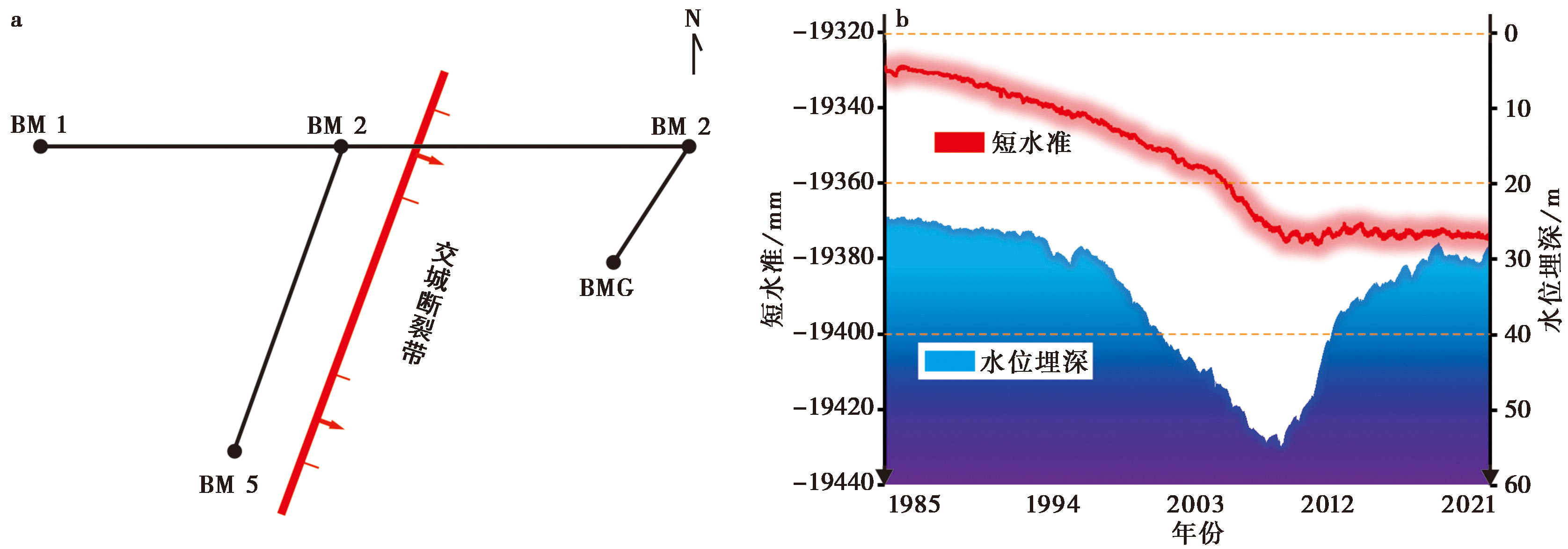
Fig. 4 Daily leveling observation results across the Jiaocheng fault zone at the Taiyuan earthquake station from 1985 to 2021.
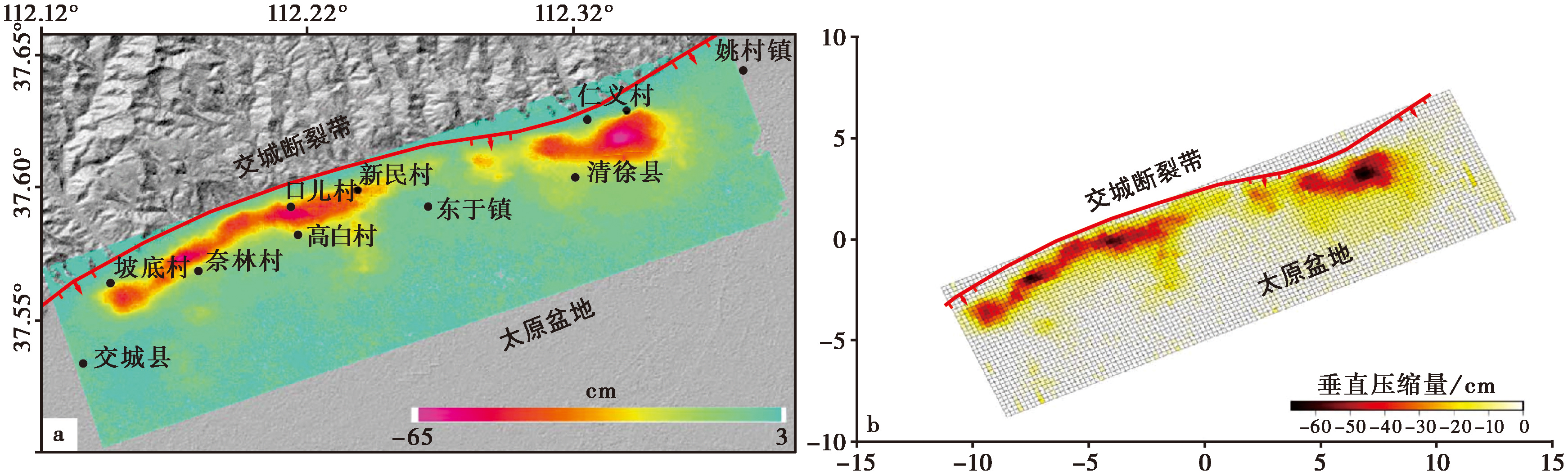
Fig. 5 Cumulative deformation and vertical compression from 2007 to 2010.
| 方法 | 地点 | 活动速率/mm·a-1 | 来源 |
|---|---|---|---|
| 跨断层水准 | 太原地震台 | 约1.18 | 本文 |
| 水准观测速率拟合 | 交城断裂带 | 3.24 | 塔拉等, |
| InSAR数据反演 | 清徐—交城一带 | 5.00 | Liu et al., |
| GPS观测 | 清徐一带 | 约2.30 | 杜伟吉, |
| GPS观测 | 中北大学附近 | 约2.68 | 李军, |
| GPS观测与数值模拟 | 交城断裂带 | 0.50±0.30 | Li et al., |
Table3 List of current vertical slip rates of the Jiaocheng fault zone from different research sources
| 方法 | 地点 | 活动速率/mm·a-1 | 来源 |
|---|---|---|---|
| 跨断层水准 | 太原地震台 | 约1.18 | 本文 |
| 水准观测速率拟合 | 交城断裂带 | 3.24 | 塔拉等, |
| InSAR数据反演 | 清徐—交城一带 | 5.00 | Liu et al., |
| GPS观测 | 清徐一带 | 约2.30 | 杜伟吉, |
| GPS观测 | 中北大学附近 | 约2.68 | 李军, |
| GPS观测与数值模拟 | 交城断裂带 | 0.50±0.30 | Li et al., |
| 活动分段 | 活动时期 | |
|---|---|---|
| 晚更新世以来平均垂向活动速率/mm·a-1 | 全新世以来平均垂向活动速率/mm·a-1 | |
| 上兰段 | 0.82~0.90 | 0.63~1.04 |
| 晋祠段 | 0.98~1.17 | 0.23~0.45 |
| 清徐—文水段 | 0.51~1.66 | 0.44~1.54 |
| 汾阳段 | 约0.43 | 约0 |
Table4 Average vertical slip rates of the Jiaocheng fault zone at different time period based on tectonic geomorphology survey and excavated trench
| 活动分段 | 活动时期 | |
|---|---|---|
| 晚更新世以来平均垂向活动速率/mm·a-1 | 全新世以来平均垂向活动速率/mm·a-1 | |
| 上兰段 | 0.82~0.90 | 0.63~1.04 |
| 晋祠段 | 0.98~1.17 | 0.23~0.45 |
| 清徐—文水段 | 0.51~1.66 | 0.44~1.54 |
| 汾阳段 | 约0.43 | 约0 |

Fig. 6 Distribution of slip rates in the Jiaocheng fault zone since late Pleistocene.
| [1] |
程新原, 侯廷爱. 1996. 交城断裂中段的活动特征及其地震危险性[J]. 山西地震, 86(3): 28—32.
|
|
|
|
| [2] |
邓起东, 王克鲁, 汪一鹏, 等. 1973. 山西隆起区断陷地震带地震地质条件及地震发展趋势概述[J]. 地质科学, 8(1): 37—47.
|
|
|
|
| [3] |
杜伟吉. 2013. 基于GPS和跨断层水准的汾渭断陷带地壳形变特征研究[D]. 西安: 长安大学:38—39.
|
|
|
|
| [4] |
郭慧, 江娃利, 谢新生. 2012. 山西交城断裂北端及中段3个大型探槽全新世断错现象分析[J]. 地震地质, 34(1): 76—92. doi: 10.3969/j.issn.0253-4967.2012.01.008.
|
|
|
|
| [5] |
江娃利, 郭慧, 谢新生, 等. 2017. 山西交城活动断裂带分布图(1︰50000)说明书[M]. 北京: 地震出版社.
|
|
|
|
| [6] |
江娃利, 聂宗笙, 张康富. 1992. 山西交城断裂错断全新世洪积扇[J]. 地震地质, 14(3): 216.
|
|
|
|
| [7] |
江娃利, 聂宗笙, 张康富. 1993. 山西交城断裂全新世活动证据及第四纪活动历史 [G]//中国地震局地壳应力所(编). 地壳构造与地壳应力文集. 北京: 地震出版社: 98—104.
|
|
|
|
| [8] |
江娃利, 谢新生, 王瑞, 等. 2004. 山西断陷系交城断裂全新世古地震活动初步研究[J]. 地震研究, 27(2): 184—190.
|
|
|
|
| [9] |
荆红亮, 张瑞芳, 张聪聪, 等. 2020. 形变速率累加法在山西定点水准观测分析及映震的研究[J]. 地震工程学报, 42(2): 403—409.
|
|
|
|
| [10] |
荆振杰, 刘凤香, 杜义, 等. 2016. 山西太谷断裂南段晚更新世以来的活动特征[J]. 地质通报, 35(9): 1559—1569.
|
|
|
|
| [11] |
李军. 2016. 太原市现今地面沉降特征分析[J]. 测绘科学, 41(7): 73—76, 81.
|
|
|
|
| [12] |
李自红, 曾金艳, 冉洪流. 2014. 交城断裂带北段最大潜在地震发震概率评估[J]. 震灾防御技术, 9(4): 770—781.
|
|
|
|
| [13] |
马保起, 许桂林, 盛小青, 等. 1999. 山西交城断裂活动的构造地貌学研究 [G]//中国地震局地壳应力所(编). 地壳构造与地壳应力文集. 北京: 地震出版社: 7—15.
|
|
|
|
| [14] |
孟振江. 2012. 交城断裂带地裂缝发育特征及成因机理研究[D]. 西安: 长安大学.
|
|
|
|
| [15] |
彭建兵, 范文, 李喜安, 等. 2007. 汾渭盆地地裂缝成因研究中的若干关键问题[J]. 工程地质学报, (4): 432—440.
|
|
|
|
| [16] |
彭建兵, 卢全中, 黄强兵, 等. 2017. 汾渭盆地地裂缝灾害[M]. 北京: 科学出版社:74—97.
|
|
|
|
| [17] |
师芸, 李伟轩, 唐亚明, 等. 2019. 时序InSAR技术在地球环境监测及其资源管理中的应用: 以交城—清徐地区为例[J]. 武汉大学学报(信息科学版), 44(11): 1613—1621.
|
|
|
|
| [18] |
孙昌斌, 谢新生, 江娃利. 2012. 河流冲沟裂点展布对全新世断层活动事件的响应——以山西交城断裂为例[J]. 地震地质, 34(2): 254—268. doi: 10.3969/j.issn.0253-4967.2012.02.005.
|
|
|
|
| [19] |
塔拉, 陈阜超, 周海涛, 等. 2014. 山西地区现代地壳垂直运动研究[J]. 大地测量与地球动力学, 34(1): 32—37.
|
|
|
|
| [20] |
王长在. 2021. 山西裂谷中部及川西地区的深部构造研究[D]. 北京: 中国地震局地球物理研究所.
|
|
|
|
| [21] |
王乃樑, 杨景春, 夏正楷, 等. 1996. 山西地堑系新生代沉积与构造地貌[M]. 北京: 科学出版社:260—277.
|
|
|
|
| [22] |
王磊. 2018. 交城地区第四纪沉积物粒度特征及其沉积环境分析[D]. 北京: 中国地质大学(北京):17—34.
|
|
|
|
| [23] |
谢新生, 赵晋泉, 江娃利, 等. 2007. 山西交城断裂带西张探槽全新世古地震研究[J]. 地震地质, 29(4): 744—755. doi: 10.3969/j.issn.0253-4967.2007.04.005.
|
|
|
|
| [24] |
谢新生, 江娃利, 孙昌斌, 等. 2008. 山西交城断裂带多个大探槽全新世古地震活动对比研究[J]. 地震地质, 30(2): 412—430. doi: 10.3969/j.issn.0253-4967.2008.02.007.
|
|
|
|
| [25] |
熊志涛, 王军霞, 刘建奎. 2013. 太原盆地煤炭开采对地下水资源的影响分析[J]. 工程勘察, 41(2): 35—39, 44.
|
|
|
|
| [26] |
许桂林, 马保起, 江娃利. 1998. 山西交城断裂带第四纪活动习性及其分段特征[G]//中国地震局地壳应力研究所(编). 地壳构造与地壳应力文集. 北京: 地震出版社: 13—21.
|
|
|
|
| [27] |
尹新义, 任建业, 裴健翔, 等. 2010. 琼东南盆地断裂活动性定量计算及其发育演化模式[J]. 高校地质学报, 16(3): 388—396.
|
|
|
|
| [28] |
喻克智. 1977. 山西地质构造及地震活动特征[J]. 山西地震, 20(1): 44—51.
|
|
|
|
| [29] |
张井飞, 谢富仁, 荆振杰, 等. 2011. 太原盆地地震潜势分析[J]. 大地测量与地球动力学, 31(5): 47—51.
|
|
|
|
| [30] |
张淑亮, 王霞, 刘瑞春, 等. 2015. 太原井水位的快速上升与构造活动的关系[J]. 震灾防御技术, 10(1): 46—58.
|
|
|
|
| [31] |
赵晋泉, 曾金艳, 程新原, 等. 2008. 山西清徐县境内交城断裂带、 地裂缝勘察及地震活动性评价报告[R]. 山西: 山西省地震工程勘察研究院.
|
|
|
|
| [32] |
庄其天. 2022 山西地堑系太原盆地晚新生代沉积环境和盆地演化[D]北京: 中国地震局地质研究所:70—82.
|
|
|
|
| [33] |
|
| [34] |
|
| [35] |
|
| [36] |
|
| [37] |
DOI URL |
| [38] |
DOI URL |
| [39] |
|
| [40] |
|
| [41] |
|
| [42] |
|
| [43] |
|
| [44] |
|
| [1] | CHANG Yu-qiao, ZHANG Hui-ping, ZHAO Xu-dong. RESEARCH ADVANCES OF THE LATE QUATERNARY ACTIVITY OF XIAOJIANG FAULT ZONE IN THE SOUTHEASTERN MARGIN OF QINGHAI-XIZANG PLATEAU [J]. SEISMOLOGY AND GEOLOGY, 2026, 48(2): 279-313. |
| [2] | XU Wei, LI Guang-tao, CHENG Li, ZOU Zi-nan. LATE QUATERNARY ACTIVITY CHARACTERISTICS IN THE SHIBAN RIVER TO NANNIWAN SEGMENT OF THE SOUTHERN MAOMAOSHAN MARGINAL FAULT [J]. SEISMOLOGY AND GEOLOGY, 2026, 48(2): 386-402. |
| [3] | CHEN Yan-wen, YUAN Dao-yang, YAO Yun-sheng, YU Jin-chao, WEN Ya-meng, SU Rui-huan, SUN Hao. CHARACTERISTICS OF LATE QUATERNARY ACTIVITY AND TECTONIC IMPLICATIONS OF THE MAYAXUESHAN FAULT IN THE EASTERN QILIAN SHAN [J]. SEISMOLOGY AND GEOLOGY, 2025, 47(6): 1566-1585. |
| [4] | CHEN Chang-yun, YIN Hai-quan. CRUSTAL DEFORMATION CHARACTERISTICS AND PROBABILITY PREDICTION OF STRONG EARTHQUAKE RISK IN XINJIANG AND ITS ADJACENT REGION [J]. SEISMOLOGY AND GEOLOGY, 2025, 47(2): 384-404. |
| [5] | ZHU Shuang, GUO Nan-nan, PANG Ya-jin. STUDY ON FAULT DEFORMATION CHARACTERISTICS AND SEISMIC HAZARD IN THE KEPING THRUST BELT [J]. SEISMOLOGY AND GEOLOGY, 2025, 47(2): 448-462. |
| [6] | XU Bin-bin, ZHANG Yi-peng, LU Le-jun, TIAN Qing-ying, YANG Xue, WANG Yang, ZHANG Pei-zhen. STUDY ON SEISMOGENIC TECTONICS OF THE 2025 MYANMAR MS7.9 EARTHQUAKE [J]. SEISMOLOGY AND GEOLOGY, 2025, 47(2): 649-670. |
| [7] | HUA Chun-yu, SHI Feng, WEI Zhan-yu. STUDY ON THE SLIP RATE OF THE BAISHA RIVER SEGMENT IN THE YINGXIU-BEICHUAN FAULT IN THE LONGMENSHAN FAULT ZONE [J]. SEISMOLOGY AND GEOLOGY, 2024, 46(6): 1295-1313. |
| [8] | PANG Zhen-hui, XU Hao-ting, SHI Xu-hua, GE Jin, LI Feng. GEOMORPHIC DATING OF SCARPS AND ITS APPLICATION TO ACTIVE TECTONICS AND GEOMORPHOLOGY [J]. SEISMOLOGY AND GEOLOGY, 2024, 46(2): 251-276. |
| [9] | LIU Xin, WANG Shi-rou, SHI Xu-hua, SU Cheng, LU Chen-yan, QIAN Xiao-yuan, SUN Qiao-yang, DENG Hong-dan, YANG Rong, CHENG Xiao-gan. APPLICATION OF DEEP LEARNING IN ACTIVE TECTONICS AND GEOMORPHOLOGY [J]. SEISMOLOGY AND GEOLOGY, 2024, 46(2): 277-296. |
| [10] | HUANG Wei-liang, ZHANG Jia-le, XIANG Wen, YANG Qian-hao. THE LATE QUATERNARY ACTIVITY CHARACTERISTICS AND SLIP RATE OF BATANG FAULT IN SE TIBETAN PLATEAU [J]. SEISMOLOGY AND GEOLOGY, 2023, 45(6): 1265-1285. |
| [11] | CHEN Yi, ZHAO Bin, XIONG Wei, WANG Wei, YU Peng-fei, YU Jian-sheng, WANG Dong-zhen, CHEN Wei, QIAO Xue-jun. INTERSEISMIC SLIP RATES AND SHALLOW CREEP ALONG THE NORTHWESTERN SEGMENT OF THE XIANSHUIHE FAULT FROM INSAR DATA [J]. SEISMOLOGY AND GEOLOGY, 2023, 45(5): 1074-1091. |
| [12] | ZHAO Peng, LI Jun-hui, TAO Yue-chao, SHU Peng, FANG Zhen. NEW ACTIVITY PHENOMENA REVEALED BY TRENCH ON THE NORTH SIDE OF NÜSHAN LAKE IN THE TANLU FAULT ZONE AND DISCUSSION [J]. SEISMOLOGY AND GEOLOGY, 2023, 45(2): 338-354. |
| [13] | YUAN Hao-dong, LI An, HUANG Wei-liang, HU Zong-kai, ZUO Yu-qi, YANG Xiao-ping. GEOLOGICAL DEFORMATION OF THE TUOLI FAULT IN THE WEST JUNGGAR SINCE THE LATE QUATERNARY [J]. SEISMOLOGY AND GEOLOGY, 2023, 45(1): 49-66. |
| [14] | YANG Yuan-yuan, LI Peng-fei, LU Shuo, SHU Peng, PAN Hao-bo, FANG Liang-hao, ZHENG Hai-gang, ZHAO Peng, ZHENG Ying-ping, YAO Da-quan. PALEOEARTHQUAKES AND VERTICAL SLIP RATES ON THE HUAI RIVER-NÜSHAN LAKE SEGMENT OF FAULT F5 IN THE MIDDLE SECTION OF THE TANLU FAULT ZONE [J]. SEISMOLOGY AND GEOLOGY, 2022, 44(6): 1365-1383. |
| [15] | ZHANG Xiu-li, XIONG Jian-guo, ZHANG Pei-zhen, LIU Qing-ri, YAO Yong, ZHONG Yue-zhi, ZHANG Hui-ping, LI You-li. STUDY ON THE SLIP RATE OF THE NORTH ZHONGTIAO SHAN FAULT SINCE THE LATE MIDDLE PLEISTOCENE [J]. SEISMOLOGY AND GEOLOGY, 2022, 44(6): 1403-1420. |
| Viewed | ||||||
|
Full text |
|
|||||
|
Abstract |
|
|||||
Copyright © SEISMOLOGY AND GEOLOGY, All Rights Reserved.
Tel: 010-62009049/9063 E-mail: dzdz@ies.ac.cn
Powered by Beijing Magtech Co., Ltd.