地震地质 ›› 2022, Vol. 44 ›› Issue (3): 649-668.DOI: 10.3969/j.issn.0253-4967.2022.03.006
董泽义1)( ), 汤吉1),*(), 赵国泽1), 陈小斌2), 崔腾发3), 韩冰1), 姜峰4), 王立凤1)
收稿日期:2021-05-06
修回日期:2021-09-28
出版日期:2022-06-20
发布日期:2022-08-02
通讯作者:
汤吉
作者简介:董泽义, 男, 1984年生, 2015年于中国地震局地质研究所获固体地球物理专业博士学位, 助理研究员, 主要从事大地电磁深部结构探测研究, E-mail: dongzeyi@ies.ac.cn。
基金资助:
DONG Ze-yi1)(), TANG Ji1),*(), ZHAO Guo-ze1), CHEN Xiao-bin2), CUI Teng-fa3), HAN Bing1), JIANG Feng4), WANG Li-feng1)
Received:2021-05-06
Revised:2021-09-28
Online:2022-06-20
Published:2022-08-02
Contact:
TANG Ji
摘要:
开展极低频电磁(CSELF)台网区、 台站的地下背景电性结构探测对于发挥其在地震预测预报研究中的作用具有重要意义。文中在首都圈CSELF电磁台网的每个台站附近布设了一条短的宽频带大地电磁剖面, 共完成了60个测点的数据采集, 对数据进行了处理与分析。首先, 通过大地电磁一维反演获得每个台站和测点下方的电阻率结构; 然后, 利用二维反演技术获得每个台站沿剖面的地壳电性结构; 最后, 对整个台网区的台站数据进行三维反演, 获得台网区三维地壳电性结构。结果表明, 华北北部阴山-燕山造山带、 中部的太行山地区和东部的胶-辽地块的地壳电性结构主要表现为高阻特征, 华北平原和山西断陷区域表现为相对低阻; 太行山重力梯度带与郯庐断裂带两侧的电性结构差异明显, 表现为电性边界带; 台网区的电性结构特征与区域地质构造、 地震活动性特征具有明显的相关性。首都圈CSELF台网区地下电性结构探测为区域的孕震环境、 地震电磁异常信号的产生机理以及地震预测预报研究工作提供了重要的参考资料。
中图分类号:
董泽义, 汤吉, 赵国泽, 陈小斌, 崔腾发, 韩冰, 姜峰, 王立凤. 首都圈极低频电磁台网区地下电性结构探测[J]. 地震地质, 2022, 44(3): 649-668.
DONG Ze-yi, TANG Ji, ZHAO Guo-ze, CHEN Xiao-bin, CUI Teng-fa, HAN Bing, JIANG Feng, WANG Li-feng. PROBING THE SUBSURFACE ELECTRIC STRUCTURE FOR CSELF NETWORK IN CAPITAL CIRCLE REGION[J]. SEISMOLOGY AND GEOLOGY, 2022, 44(3): 649-668.
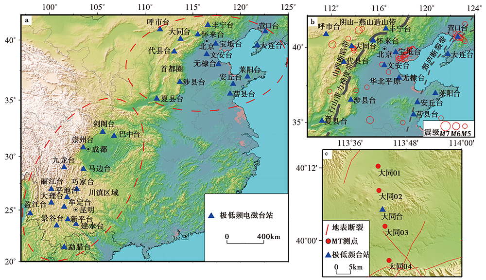
图 1 首都圈极低频电磁台网区的电性结构测量 a 中国大陆极低频电磁台网; b 首都圈CSELF台网区的地质构造简图; c 大同台结构测量测点分布
Fig. 1 Investigation of electrical resistivity structures beneath the CSELF network in the capital circle region.
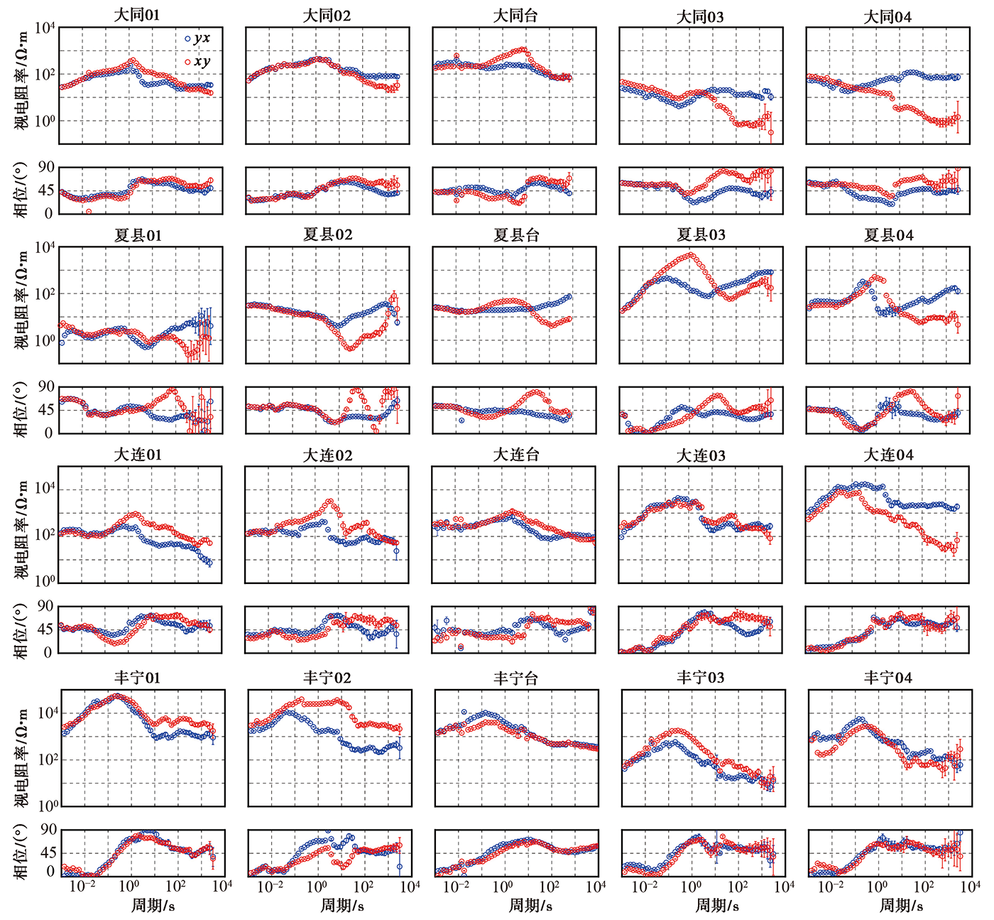
图 2 大同台、 夏县台、 大连台和丰宁台沿剖面测点的视电阻率与阻抗相位曲线
Fig. 2 Apparent resistivity and phase curves for all sites along the MT profile at Datong, Xiaxian, Dalian and Fengning observational stations.
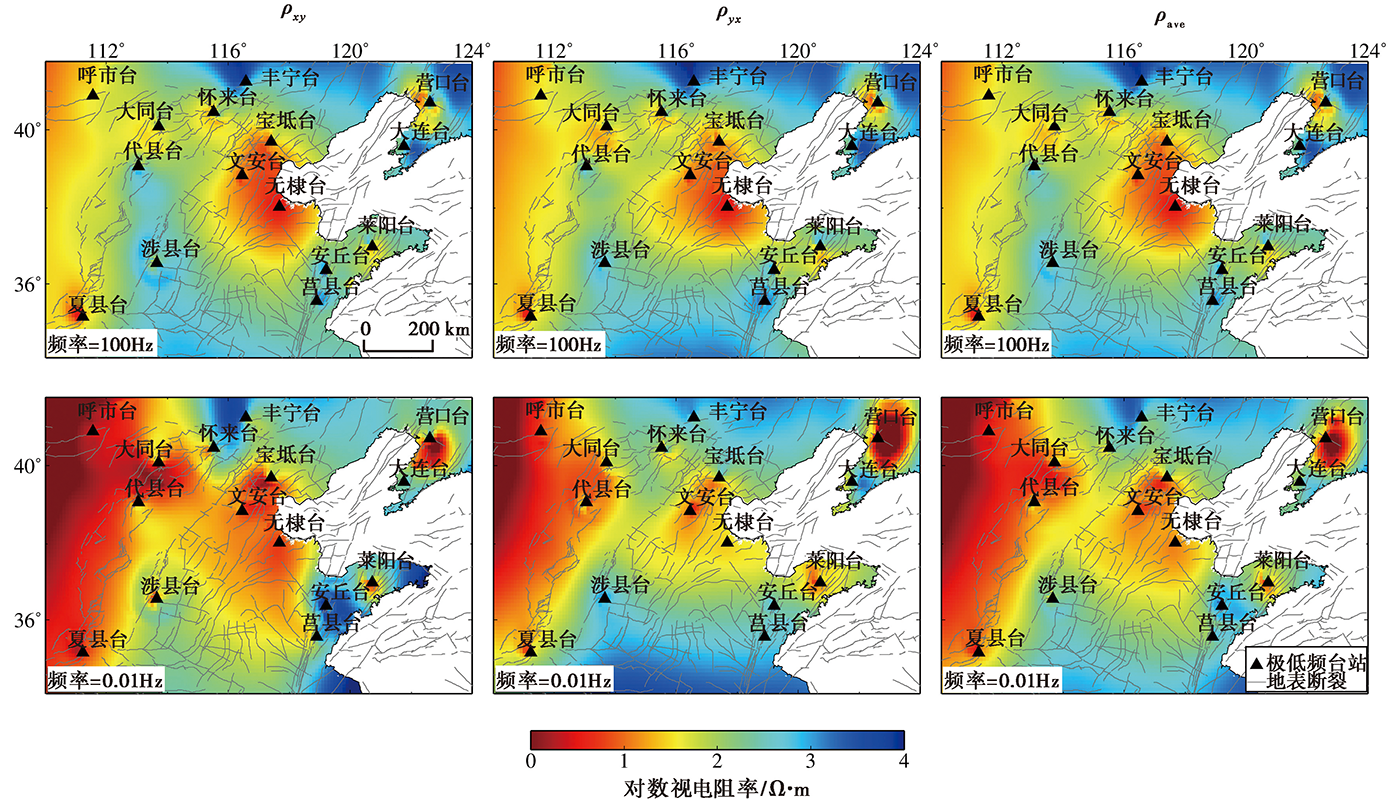
图 3 首都圈CSELF电磁台网区不同频率的视电阻率分布图 ρxy xy向视电阻率; ρyx yx向视电阻率; ρave xy与yx向视电阻率的几何平均
Fig. 3 Apparent resistivity maps at 100Hz and 0.01Hz of the CSELF network in the capital circle region.
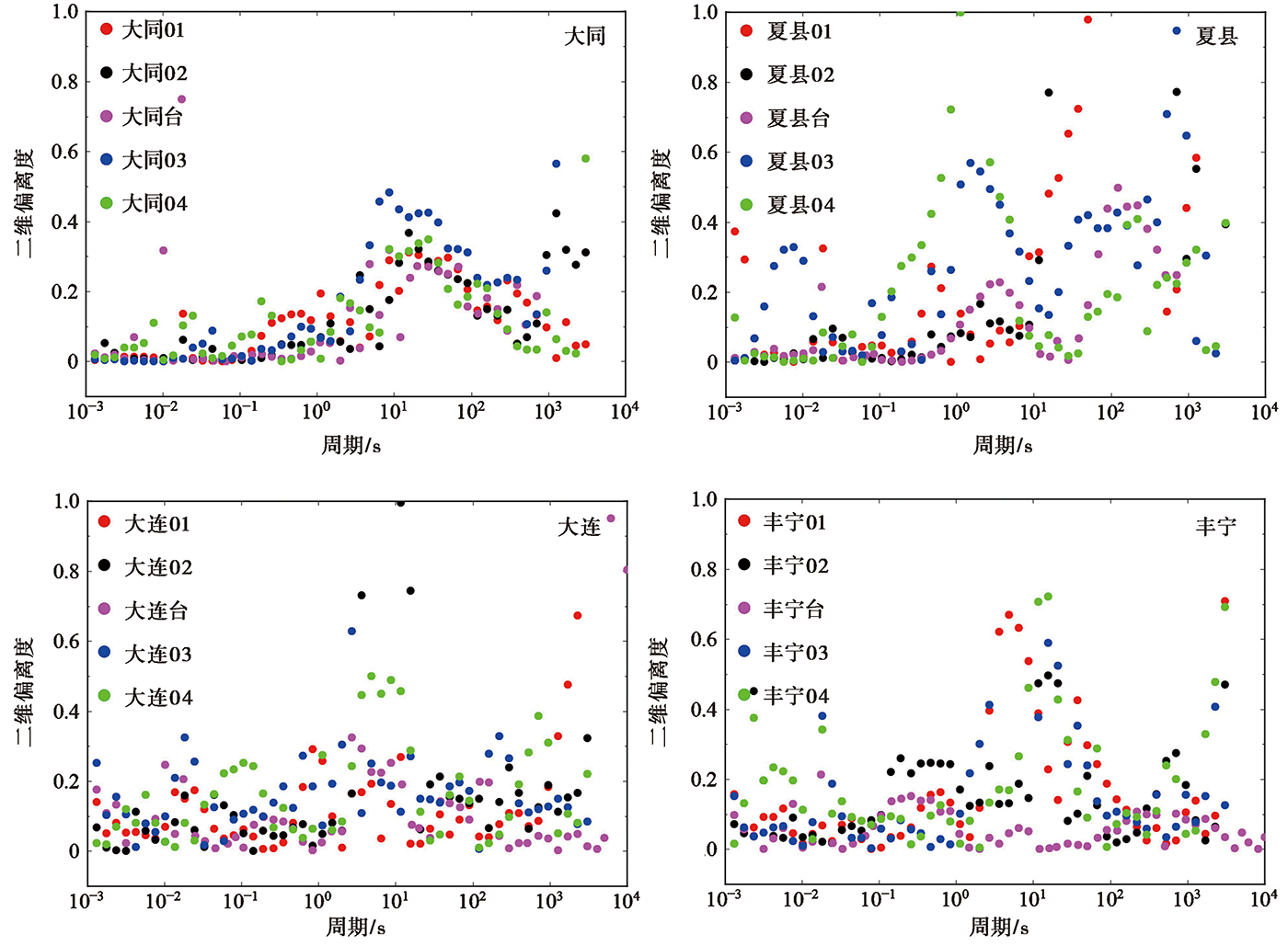
图 4 不同台站每个测点的二维偏离度
Fig. 4 The 2D skewness at each site for Datong, Xiaxian, Dalian and Fengning staions.
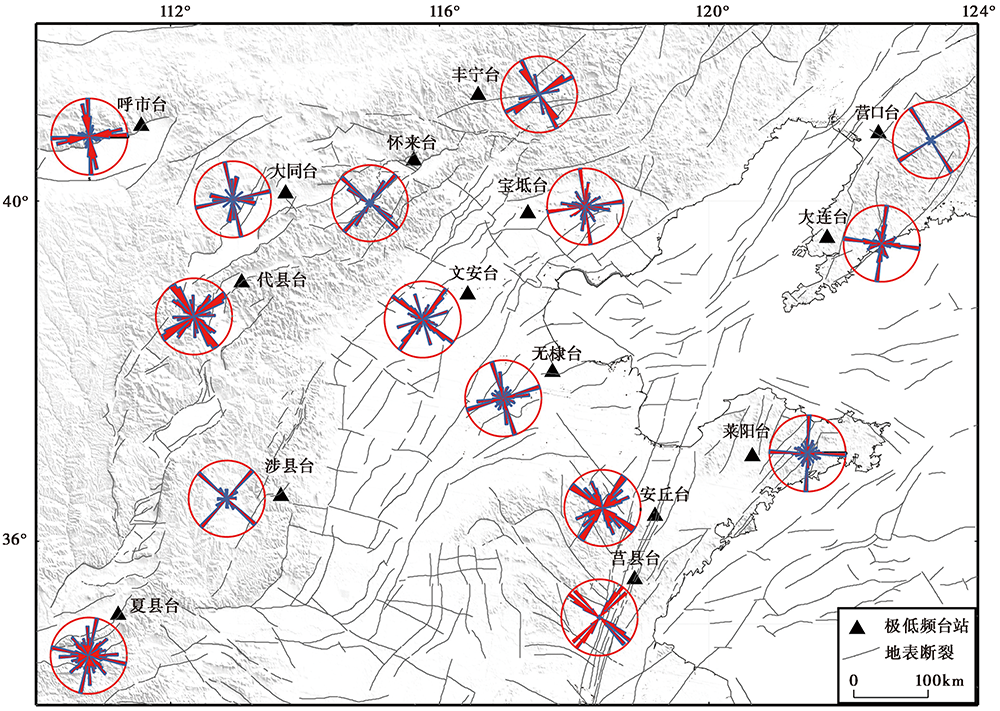
图 5 首都圈CSELF台网各台站的电性主轴方位玫瑰图
Fig. 5 Rose diagrams of geoeletrical strike at each station of the CSELF network in capital circle region.
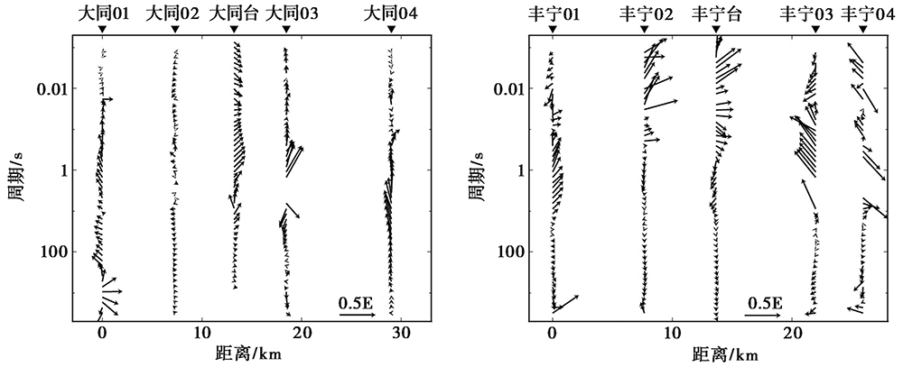
图 6 大同台和丰宁台沿剖面的实感应矢量拟断面图
Fig. 6 Pseudo-sections of the real induced vector along the MT profile at Datong and Fengning stations.
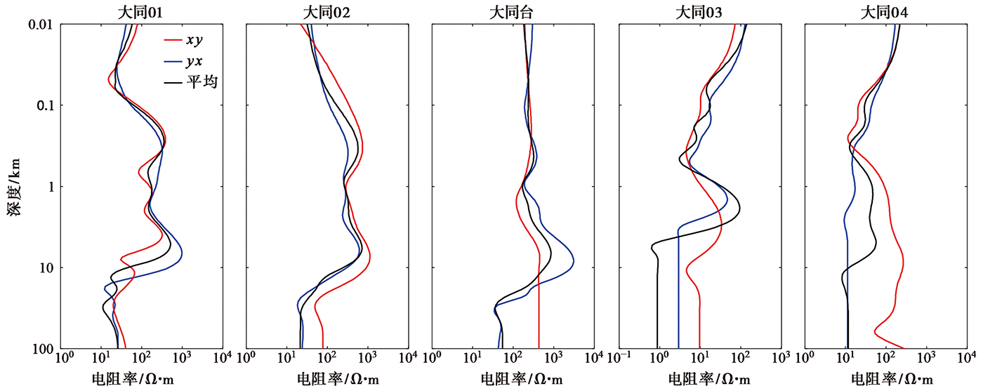
图 7 大同台及其MT测点的一维反演结果
Fig. 7 The 1-D resistiviy structures for Datong station and MT sites.
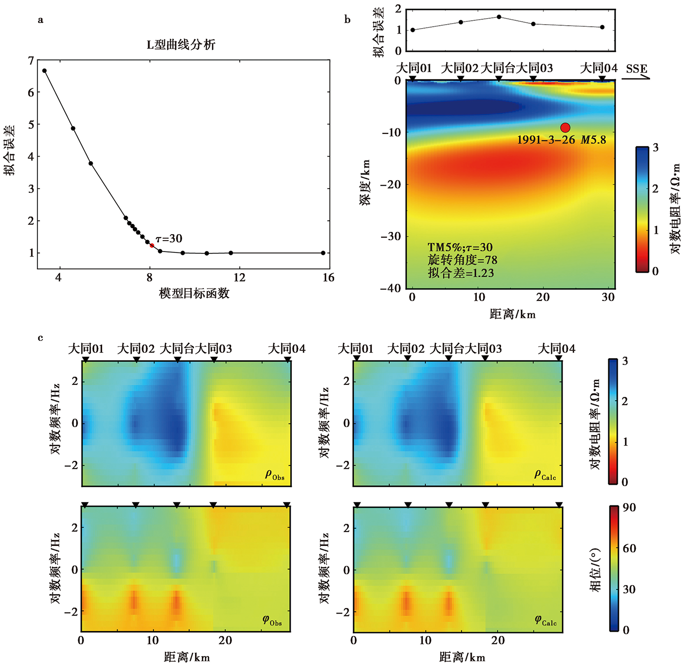
图 8 大同台MT剖面的二维反演 a 不同光滑因子的L曲线; b 大同台沿MT剖面的地壳电性结构; c 二维反演数据与模型响应拟断面图。 ρObs观测视电阻率; ρCalc 模型响应电阻率; φObs 观测相位; φCalc 模型响应相位
Fig. 8 Two-diminsional inversion of MT profile at Datong station.

图 9 首都圈CSELF电磁台网区二维反演模型不同深度的电阻率切片
Fig. 9 Horizontal slices of 2-D electrical resistivity structure of the CSELF network in capital circle region at different depths.
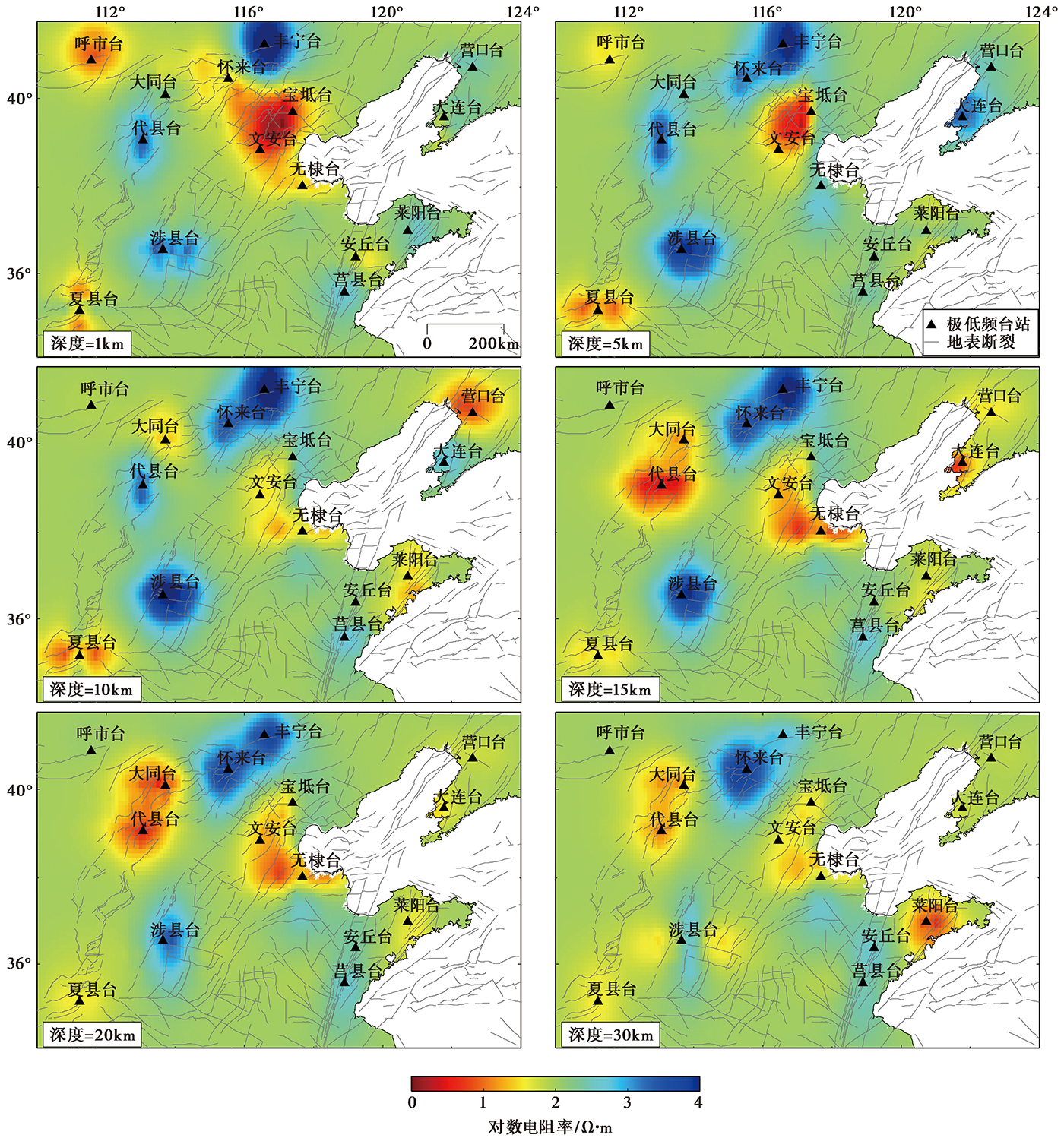
图 10 首都圈CSELF电磁台网三维反演模型不同深度的切片
Fig. 10 Horizontal slices of 3-D electrical resistivity structure of the CSELF network in capital circle region at different depths.
| [1] | 蔡军涛, 陈小斌, 赵国泽. 2010. 大地电磁资料精细处理和二维反演解释技术研究(二): 反演数据极化模式选择[J]. 地球物理学报, 53(11): 2703—2714. |
| CAI Jun-tao, CHEN Xiao-bin, ZHAO Guo-ze. 2010. Refined techniques for data processing and two-dimensional inversion in magnetotelluric Ⅱ: Which data polarization mode should be used in 2D inversion[J]. Chinese Journal of Geophysics, 53(11): 2703—2714 (in Chinese). | |
| [2] | 陈乐寿, 王光锷. 1990. 大地电磁测深法[M]. 北京: 地质出版社. |
| CHEN Le-shou, WANG Guang-e. 1990. Method of Magnetotelluric Sounding[M]. Geological Publishing House, Beijing (in Chinese). | |
| [3] | 陈小斌, 蔡军涛, 王立凤, 等. 2014. 大地电磁资料精细处理和二维反演解释技术研究(四): 阻抗张量分解的多测点-多频点统计成像分析[J]. 地球物理学报, 57(6): 1946—1957. |
| CHEN Xiao-bin, CAI Jun-tao, WANG Li-feng, et al. 2014. Refined techniques for magnetotelluric data processing and two-dimensional inversion(Ⅳ): Statistical image method based on multi-site, multi-frequency tensor decomposition[J]. Chinese Journal of Geophysics, 57(6): 1946—1957 (in Chinese). | |
| [4] | 陈小斌, 赵国泽. 2009. 自动构建大地电磁二维反演的测点中心网格[J]. 地球物理学报, 52(6): 1564—1572. |
| CHEN Xiao-bin, ZHAO Guo-ze. 2009. Automatic construction of a site-centered grid(SCG)for 2D magnetotelluric inversion[J]. Chinese Journal of Geophysics, 52(6): 1564—1572 (in Chinese). | |
| [5] | 陈小斌, 赵国泽, 汤吉, 等. 2005. 大地电磁自适应正则化反演算法[J]. 地球物理学报, 48(4): 937—946. |
| CHEN Xiao-bin, ZHAO Guo-ze, TANG Ji, et al. 2005. An adaptive regularized inversion algorithm for magnetotelluric data[J]. Chinese Journal of Geophysics, 48(4): 937—946 (in Chinese). | |
| [6] | 陈小斌, 赵国泽, 詹艳. 2004. MT资料处理与解释的Windows可视化集成系统[J]. 石油地球物理勘探, 39(S1): 11—16. |
| CHEN Xiao-bin, ZHAO Guo-ze, ZHAN Yan. 2004. A visual integrated windows system for MT data process and interpretation[J]. Oil Geophysical Prospecting, 39(S1): 11—16 (in Chinese). | |
| [7] | 陈颙, 李娟. 2003. 2001年地球物理学的一些进展[J]. 地球物理学进展, 18(1): 1—4. |
| CHEN Yong, LI Juan. 2003. Advances of geophysics in 2001[J]. Progress in Geophysics, 18(1): 1—4 (in Chinese). | |
| [8] | 陈运泰. 2009. 地震预测: 回顾与展望[J]. 中国科学(D辑), 39(12): 1633—1658. |
| [9] | CHEN Yun-tai. 2009. Earthquake prediction: Retrospect and prospect[J]. Science in China(Ser D), 39(12): 1633—1658 (in Chinese). |
| [10] | 高曙德, 汤吉, 杜学彬, 等. 2010. 汶川8.0级地震前后电磁场的变化特征[J]. 地球物理学报, 53(3): 512—525. |
| GAO Shu-de, TANG Ji, DU Xue-bin, et al. 2010. The change characteristics of electromagnetic filed before to after Wenchuan MS8.0 earthquake[J]. Chinese Journal of Geophysics, 53(3): 512—525 (in Chinese). | |
| [11] | 黄清华, 刘涛. 2006. 新岛台地电场的潮汐响应与地震[J]. 地球物理学报, 49(6): 1745—1754. |
| HUANG Qing-hua, LIU Tao. 2006. Earthquake and tide response of geoelectric potential field at the Niijima station[J]. Chinese Journal of Geophysics, 46(6): 1745—1754 (in Chinese). | |
| [12] | Ouro-Djobo S B, 魏文博, 叶高峰, 等. 2018. 华北大地电磁测深阵列观测实验与岩石圈导电性快速成像模型[J]. 地球物理学报, 61(6): 2508—2524. |
| Ouro-Djobo S B, WEI Wen-bo, YE Gao-feng, et al. 2018. Experiments of magnetotelluric observation network on North China and lithospheric conductivity structure from fast imaging method[J]. Chinese Journal of Geophysics, 61(6): 2508—2524 (in Chinese). | |
| [13] | 阮帅. 2015. 三维大地电磁有限内存拟牛顿反演[D]. 成都: 成都理工大学. |
| RUAN Shuai. 2015. Three-dimensional magnetotelluric inversion based on limited memory quasi-newton method[D]. Chengdu University of Technology, Chengdu (in Chinese). | |
| [14] |
阮帅, 汤吉, 董泽义, 等. 2020. 基于三维大地电磁AR-QN反演的长白山天池火山区电性结构[J]. 地震地质, 42(6): 1282—1300. doi: 10.3969/j.issn.0253-4967.2020.06.002.
DOI |
| RUAN Shuai, TANG Ji, DONG Ze-yi, et al. 2020. Electric structure model of Tianchi volcano in Changbai Mountains based on three-dimensional AR-QN magnetotelluric inversion[J]. Seismology and Geology, 42(6): 1282—1300 (in Chinese). | |
| [15] | 汤吉, 赵国泽, 王继军, 等. 1998. 张北-尚义地震前后电阻率的变化及分析[J]. 地震地质, 20(2): 164—171. |
| TANG Ji, ZHAO Guo-ze, WANG Ji-jun, et al. 1998. Variation and analysis of resistivity before and after the Zhangbei-Shangyi earthquake[J]. Seismology and Geology, 20(2): 164—171 (in Chinese). | |
| [16] | 王培德, Klaus S. 2000. 1989年10月和1991年3月大同地震的活动断裂[J]. 地震地磁观测与研究, 21(6): 19—26. |
| WANG Pei-de, Klaus S. 2000. Active faults of the Datong earthquakes of October 1989 and March 1991[J]. Seismological and Geomagnetic Observation and Research, 21(6): 19—26 (in Chinese). | |
| [17] | 魏文博, 金胜, 叶高峰, 等. 2006. 华北地区大地电磁测深及岩石圈厚度讨论[J]. 中国地质, 33(4): 762—772. |
| WEI Wen-bo, JIN Sheng, YE Gao-feng, et al. 2006. MT sounding and lithosphere thickness in North China[J]. Geology in China, 33(4): 762—772 (in Chinese). | |
| [18] | 魏文博, 叶高峰, 金胜, 等. 2008. 华北地区东部岩石圈导电性结构研究: 减薄的华北岩石圈特点[J]. 地学前缘, 15(4): 204—216. |
|
WEI Wen-bo, YE Gao-feng, JIN Sheng, et al. 2008. Geoelectric structure of lithosphere beneath eastern North China: Features of a thinned lithosphere from magnetotelluric soundings[J]. Earth Science Frontiers, 15(4): 204—216 (in Chinese).
DOI URL |
|
| [19] | 叶高峰, 魏文博, 金胜, 等. 2009. 郯庐断裂带中段电性结构及其地学意义研究[J]. 地球物理学报, 52(11): 2818—2825. |
| YE Gao-feng, WEI Wen-bo, JIN Sheng, et al. 2009. Study of the electrical structure and its geological meanings of the middle part of Tancheng-Lujiang fault zone[J]. Chinese Journal of Geophysics, 52(11): 2818—2825 (in Chinese). | |
| [20] |
詹艳, 赵国泽, 王立凤, 等. 2011. 河北石家庄地区深部结构大地电磁探测[J]. 地震地质, 33(4): 913—927. doi: 10.3969/j.issn.0253-4967.2011.04.015.
DOI |
| ZHAN Yan, ZHAO Guo-ze, WANG Li-feng, et al. 2011. Deep structure in Shijiazhuang and the vicinity by magnetotellurics[J]. Seismology and Geology, 33(4): 913—927 (in Chinese). | |
| [21] |
张继红, 赵国泽, 董泽义, 等. 2019. 郯庐断裂带安丘、 莒县电磁台地壳电性结构研究[J]. 地震地质, 41(5): 1239—1253. doi: 10.3969/j.issn.0253-4967.2019.05.011.
DOI |
| ZHANG Ji-hong, ZHAO Guo-ze, DONG Ze-yi, et al. 2019. Study of the electrical structure of the Anqiu and Juxian electromagnetic stations in the Tanlu fault zone[J]. Seismology and Geology, 41(5): 1239—1253 (in Chinese). | |
| [22] | 张继红, 赵国泽, 肖骑彬, 等. 2010. 郯庐断裂带中段(沂沭断裂带)电性结构研究与孕震环境[J]. 地球物理学报, 53(3): 605—611. |
| ZHANG Ji-hong, ZHAO Guo-ze, XIAO Qi-bin, et al. 2010. Analysis of electric structure of the central Tan-Lu fault zone(Yi-Shu fault zone)and seismogenic condition[J]. Chinese Journal of Geophysics, 53(3): 605—611 (in Chinese). | |
| [23] | 张云琳, 刘晓玲, 安海静, 等. 1994. MT重复测量在地震中短期预报中的应用: 祁连山中段MT剖面监测研究[J]. 地球物理学报, 37(2): 200—210. |
| ZHANG Yun-lin, LIU Xiao-ling, AN Hai-jing, et al. 1994. Application of the MT repeated measurements to the medium and short term prediction of earthquake: Monitoring and studying a profile in the middle segment of Qilian Mountains by MT[J]. Chinese Journal of Geophysics, 37(2): 200—210 (in Chinese). | |
| [24] | 赵国泽, Bi Y X, 王立凤, 等. 2015. 中国地震交变电磁场观测数据处理技术新进展[J]. 中国科学(D辑), 45(1): 22—33. |
| ZHAO Guo-ze, Bi Y X, WANG Li-feng, et al. 2015. Advances in alternating electromagnetic field data processing for earthquake monitoring in China[J]. Science in China(Ser D), 45(1): 22—33 (in Chinese). | |
| [25] | 赵国泽, 陈小斌, 汤吉. 2007. 中国地球电磁法新进展和发展趋势[J]. 地球物理学进展, 22(4): 1171—1180. |
| ZHAO Guo-ze, CHEN Xiao-bin, TANG Ji. 2007. Advanced geo-electromagnetic methods in China[J]. Progress in Geophysics, 22(4): 1171—1180 (in Chinese). | |
| [26] | 赵国泽, 刘铁胜, 江钊, 等. 1997. 山西阳高—河北容城剖面大地电磁资料的二维反演解释[J]. 地球物理学报, 40(1): 38—46. |
| ZHAO Guo-ze, LIU Tie-sheng, JIANG Zhao, et al. 1997. Investigation on MT data along Yanggao-Rongcheng profile by two-dimensional inversion[J]. Chinese Journal of Geophysics, 40(1): 38—46 (in Chinese). | |
| [27] | 赵国泽, 陆建勋. 2003a. 利用人工源超低频电磁波监测地震的试验与分析[J]. 中国工程科学, 5(10): 27—33. |
|
ZHAO Guo-ze, LU Jian-xun. 2003a. Monitoring and analysis of earthquake phenomena by artificial SLF waves[J]. Engineering Science, 5(10): 27—33 (in Chinese).
DOI URL |
|
| [28] | 赵国泽, 汤吉, 邓前辉, 等. 2003b. 人工源超低频电磁波技术及在首都圈地区的测量研究[J]. 地学前缘, 10(S1): 248—257. |
| ZHAO Guo-ze, TANG Ji, DENG Qian-hui, et al. 2003b. Artificial SLF method and experimental study for earthquake monitoring in Beijing area[J]. Earth Science Frontiers, 10(S1): 248—257 (in Chinese). | |
| [29] | 赵国泽, 王立凤, 汤吉, 等. 2010a. 地震预测人工源极低频电磁技术(CSELF)新试验[J]. 地球物理学报, 53(3): 479—486. |
| ZHAO Guo-ze, WANG Li-feng, TANG Ji, et al. 2010a. New experiments of CSELF electromagnetic method for earthquake monitoring[J]. Chinese Journal of Geophysics, 53(3): 479—486 (in Chinese). | |
| [30] | 赵国泽, 王立凤, 詹艳, 等. 2012. 地震预测人工源极低频电磁新技术(CSELF)和第一个观测台网[J]. 地震地质, 34(4): 576—585. |
| ZHAO Guo-ze, WANG Li-feng, ZHAN Yan, et al. 2012. A new electromagnetic technique for earthquake monitoring—CSELF and the first observational network[J]. Seismology and Geology, 34(4): 576—585 (in Chinese). | |
| [31] | 赵国泽, 詹艳, 王立凤, 等. 2010b. 鄂尔多斯断块地壳电性结构[J]. 地震地质, 32(3): 345—359. |
| ZHAO Guo-ze, ZHAN Yan, WANG Li-feng, et al. 2010b. Electric structure of the crust beneath the Ordos fault block[J]. Seismology and Geology, 32(3): 345—359 (in Chinese). | |
| [32] | 赵玉林, 钱复业. 1978. 唐山7.8级强震前震中周围形变电阻率的下降异常[J]. 地球物理学报, 21(3): 181—190. |
| ZHAO Yu-lin, QIAN Fu-ye. 1978. Electrical resistivity anomaly observed in and around the epicentral area prior to the Tangshan earthquake of 1976[J]. Chinese Journal of Geophysics, 21(3): 181—190 (in Chinese). | |
| [33] |
Berdichevsky M N, Dmitriev V I, Pozdnjakova E E. 1998. On two-dimensional interpretation of magnetotelluric soundings[J]. Geophysical Journal International, 133(3): 585—606.
DOI URL |
| [34] | Bleier T, Freund F. 2005. Impending earthquake have been sending us warning signals and people are starting to listen[J]. IEEE Spectrum International, 12:17—21. |
| [35] |
Cai J T, Chen X B, Xu X W, et al. 2017. Rupture mechanism and seismotectonics of the MS6.5 Ludian earthquake inferred from three-dimensional magnetotelluric imaging[J]. Geophysical Research Letters, 44(3): 1275—1285.
DOI URL |
| [36] |
Fan W M, Zhang H F, Baker J, et al. 2000. On and off the North China craton: Where is the Archaean keel?[J]. Journal of Petrology, 41(7): 933—950.
DOI URL |
| [37] |
Gamble T D, Goubau W M, Clarke J. 1979. Magnetotellurics with a remote magnetic reference[J]. Geophysics, 44(1): 53—68.
DOI URL |
| [38] |
Gao S, Rudnick R L, Yuan H, et al. 2004. Recycling lower continental crust in the North China craton[J]. Nature, 432(7019): 892—897.
DOI URL |
| [39] | Griffin B, Andi Z, O'Reilly S, et al. 1998. Phanerozoic evolution of the lithosphere beneath the Sino-Korean craton[C]. In: Conference on Mantle Dynamics and Plate Interacton in East Asia, America Geophysical Union: 107—126. |
| [40] |
Kelbert A, Meqbel N, Egbert G D, et al. 2014. ModEM: A modular system for inversion of electromagnetic geophysical data[J]. Computers & Geosciences, 66: 40—53.
DOI URL |
| [41] |
Ledo J. 2006. 2-D versus 3-D magnetotelluric data interpretation[J]. Surveys in Geophysics, 26(5): 511—543.
DOI URL |
| [42] |
Liu D Y, Nutman A P, Compston W, et al. 1992. Remnants of ≥3 800Ma crust in the Chinese part of the Sino-Korean craton[J]. Geology, 20(4): 339—342.
DOI URL |
| [43] |
Newman G A, Alumbaugh D L. 2000. Three-dimensional magnetotelluric inversion using non-linear conjugate gradients[J]. Geophysical Journal International, 140(2): 410—424.
DOI URL |
| [44] |
Parkinson W D. 1962. The influence of continents and oceans on geomagnetic variations[J]. Geophysical Journal International, 6(4): 441—449.
DOI URL |
| [45] |
Reddy I K, Phillips R J, Whitcomb J H, et al. 1976. Monitoring of time dependent by a resistivity anomaly and its application to earthquake prediction[J]. Journal of Geomagnetism and Geoelectricity, 28(1): 47—57.
DOI URL |
| [46] |
Rodi W, Mackie R L. 2001. Nonlinear conjugate gradients algorithm for 2-D magnetotelluric inversion[J]. Geophysics, 66(1): 174—187.
DOI URL |
| [47] |
Siripunvaraporn W, Egbert G, Lenbury Y, et al. 2005. Three-dimensional magnetotelluric inversion: Data-space method[J]. Physics of the Earth and Planetary Interiors, 150(1-3): 3—14.
DOI URL |
| [48] | Uyeda S. 2015. Current affairs in earthquake prediction in Japan[J]. Journal of Asian Earth Sciences, 114(Part 2): 431—434. |
| [49] |
Xiao Q B, Shao G H, Liu-Zeng J, et al. 2015. Eastern termination of the Altyn Tagh Fault, western China: Constraints from a magnetotelluric survey[J]. Journal of Geophysical Research: Solid Earth, 120(5): 2838—2858.
DOI URL |
| [50] |
Xiao Q B, Yu G, Liu-Zeng J, et al. 2017. Structure and geometry of the Aksay restraining double bend along the Altyn Tagh Fault, northern Tibet, imaged using magnetotelluric method[J]. Geophysical Research Letters, 44(9): 4090—4097.
DOI URL |
| [51] | Xu Y G. 2001. Thermo-tectonic destruction of the Archaean lithospheric keel beneath the Sino-Korean craton in China: Evidence, timing and mechanism[J]. Physics and Chemistry of the Earth, Part A: Solid Earth and Geodesy, 26(9-10): 747—757. |
| [52] |
Zhang H Q, Huang Q H, Zhao G Z, et al. 2016. Three-dimensional conductivity model of crust and uppermost mantle at the northern Trans-North China Orogen: Evidence for a mantle source of Datong volcanoes[J]. Earth and Planetary Science Letters, 453: 182—192.
DOI URL |
| [53] |
Zhao G Z, Unsworth M J, Zhan Y, et al. 2012. Crustal structure and rheology of the Longmenshan and Wenchuan MW7.9 earthquake epicentral area from magnetotelluric data[J]. Geology, 40(12): 1139—1142.
DOI URL |
| [54] |
Zhao G Z, Zhan Y, Wang L F, et al. 2009. Electromagnetic anomaly before earthquake measured by electromagnetic experiments[J]. Earthquake Science, 22(4): 395—402.
DOI URL |
| [1] | 王明亮, 张扬, 徐顺强, 徐志萍. 华北坳陷中南部深部结构大地电磁探测[J]. 地震地质, 2023, 45(2): 536-552. |
| [2] | 赵凌强, 胡亚轩, 王庆良, 祝意青, 操聪, 李仲巍, 綦伟, 汶宇龙. 吉林龙岗火山区深部电性结构特征分析[J]. 地震地质, 2022, 44(4): 845-858. |
| [3] | 赵凌强, 詹艳, 王庆良, 孙翔宇, 韩静, 操聪, 张松, 蔡妍. 大地电磁数据揭示的1303年洪洞8级地震区精细结构[J]. 地震地质, 2022, 44(3): 686-700. |
| [4] | 韩静, 詹艳, 孙翔宇, 赵国泽, 刘雪华, 包雨鑫, 孙建宝, 彭远黔. 强电磁干扰环境下的大地电磁数据特征及处理[J]. 地震地质, 2022, 44(3): 736-752. |
| [5] | 韩冰, 汤吉, 赵国泽, 王立凤, 董泽义, 范晔, 孙贵成. 极低频台站同震电磁信号特征分析[J]. 地震地质, 2022, 44(3): 753-770. |
| [6] | 张赟昀, 王培杰, 陈小斌, 詹艳, 韩冰, 王立凤, 赵国泽. 强干扰环境下的大地电磁时间序列处理过程[J]. 地震地质, 2022, 44(3): 786-801. |
| [7] | 刘钟尹, 陈小斌, 蔡军涛, 崔腾发, 赵国泽, 汤吉, 欧阳飚. 大地电磁三维反演云计算系统toPeak的设计与实现[J]. 地震地质, 2022, 44(3): 802-820. |
| [8] | 阮帅, 汤吉, 董泽义, 王立凤, 邓琰, 韩冰. 基于三维大地电磁AR-QN反演的长白山天池火山区电性结构[J]. 地震地质, 2020, 42(6): 1282-1300. |
| [9] | 孙翔宇, 詹艳, 赵国泽, 赵凌强, 邓琰, 胡亚轩, 胡久常, 向小娟. 琼东北马鞍岭-雷虎岭火山区深部岩浆系统大地电磁三维探测[J]. 地震地质, 2020, 42(3): 640-653. |
| [10] | 孙翔宇, 詹艳, 赵凌强, 陈小斌, 李陈侠, 孙建宝, 韩静, 崔腾发. 东昆仑断裂带东端和2017年九寨沟7.0级地震区深部电性结构探测[J]. 地震地质, 2020, 42(1): 182-197. |
| [11] | 姜峰, 陈小斌, 董泽义, 崔腾发, 刘钟尹, 王培杰. 利用单剖面大地电磁三维反演识别沙德和玉农希断裂[J]. 地震地质, 2019, 41(6): 1444-1463. |
| [12] | 张继红, 赵国泽, 董泽义, 王立凤, 韩冰, 王庆林, 唐廷梅, 王梅. 郯庐断裂带安丘、莒县电磁台地壳电性结构研究[J]. 地震地质, 2019, 41(5): 1239-1253. |
| [13] | 赵凌强, 詹艳, 王庆良, 孙翔宇, 杨皓, 陈小斌. 1954年甘肃民勤7级地震区深部电性结构特征及地震构造环境研究[J]. 地震地质, 2018, 40(3): 552-565. |
| [14] | 韩江涛, 王天琪, 刘文玉, 刘国兴, 韩松, 刘立家. 阿尔山火山群深部“拱桥式”岩浆系统及其稳定性分析[J]. 地震地质, 2018, 40(3): 590-610. |
| [15] | 周耀明, 朱文斌, 陈正乐, 朱炳玉, 薛峰. 准噶尔盆地克-百断裂带火山岩分布特征的重磁资料解释[J]. 地震地质, 2018, 40(3): 641-655. |
| 阅读次数 | ||||||
|
全文 |
|
|||||
|
摘要 |
|
|||||
