地震地质 ›› 2022, Vol. 44 ›› Issue (4): 925-943.DOI: 10.3969/j.issn.0253-4967.2022.04.007
徐伟1,2)( ), 刘志成2), 王继2), 高战武2), 尹金辉1)
收稿日期:2021-06-15
修回日期:2021-08-30
出版日期:2022-08-20
发布日期:2022-09-23
作者简介:徐伟, 男, 1986年生, 2011年于中国地震局地壳应力研究所获固体地球物理学专业硕士学位, 现为中国地震局地质研究所构造地质学专业在读博士研究生, 主要从事活动构造、 第四纪年代、 构造地貌等研究, 电话: 13426220213, E-mail: xwazhy@163.com。
基金资助:
XU Wei1,2)(), LIU Zhi-cheng2), WANG Ji2), GAO Zhan-wu2), YIN Jin-hui1)
Received:2021-06-15
Revised:2021-08-30
Online:2022-08-20
Published:2022-09-23
摘要:
喀喇昆仑断裂是青藏高原西部一条大型边界断裂, 调节了印度板块与欧亚板块的碰撞变形, 在青藏高原西部构造演化过程中扮演着重要角色。阿里地区断裂迹线清晰, 断错地貌显著, 显示出晚第四纪强烈活动的特征。目前, 断裂最近的强震活动时代、 复发间隔等地震活动性参数尚不清楚, 极大地限制了地震危险性评估的准确性。文中对阿里地区的断裂几何结构、 断错地貌进行了调查, 在扎西岗乡、 门士乡、 巴嘎乡等地对断错地貌面及断塞塘进行了光释光年代样品采集。研究结果表明, 断裂以扎西岗乡、 索多村为界分可为3段, 各段断裂结构及性质差异显著; 断裂最近的强震活动在扎西岗乡西、 门士乡东以及巴嘎乡一带, 时间分别约为2.34kaBP、 3.01kaBP及2.54kaBP。断裂最近的强震活动距今的时间可能已非常接近地震复发间隔, 其能量积累或已达到了非常高的程度, 再次发生强震事件的危险性很大, 需引起足够重视, 尽快对断裂的古地震事件、 复发间隔等地震活动性参数开展细致的研究。
中图分类号:
徐伟, 刘志成, 王继, 高战武, 尹金辉. 西藏阿里地区喀喇昆仑断裂断错地貌及最近强震活动时代的初步研究[J]. 地震地质, 2022, 44(4): 925-943.
XU Wei, LIU Zhi-cheng, WANG Ji, GAO Zhan-wu, YIN Jin-hui. PRELIMINARY STUDY ON FAULTED LANDFORMS AND AGES OF RECENT STRONG EARTHQUAKE ACTIVITY ON THE KARAKORUM FAULT IN NGARI, TIBET[J]. SEISMOLOGY AND GEOLOGY, 2022, 44(4): 925-943.
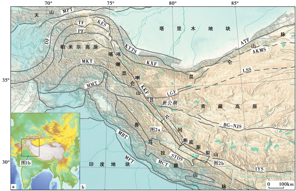
图1 喀喇昆仑断裂区域的构造格局(改自Cowgill, 2010) MPT主帕米尔逆冲断裂; DF达瓦孜断裂; TF塔尼玛斯断裂; KES公格尔拉张正断裂系; PF帕萨特断裂; MKT主喀喇昆仑逆冲断裂; KKF喀喇昆仑断裂; KYTS喀什一叶城转换断裂; KXF康西瓦断裂; ATF阿尔金断裂; LGF龙木错-郭扎错断裂;AKMS阿尼玛卿-昆仑-慕士塔格缝合带; LSS龙木错-双湖缝合带; BG-NJS 班公湖-怒江缝合带; IYS印度-雅鲁藏布江缝合带; STDS藏南拆离系; MMT喜马拉雅主地幔逆冲断裂; MCT喜马拉雅主中央逆冲断裂; MBT喜马拉雅主边界逆冲断裂;MFT喜马拉雅主前缘逆冲断裂
Fig. 1 Regional tectonic framework of Karakorum Fault( modified from Cowgill, 2010)
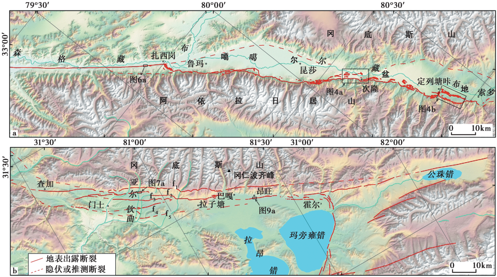
图2 阿里地区喀喇昆仑断裂的展布特征
Fig. 2 Distribution characteristics of Karakorum Fault in Ngari Prefecture.
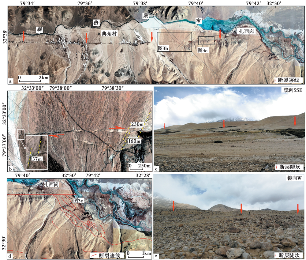
图3 扎西岗乡以西段的卫星影像及典型部位断错地貌 a 扎西岗乡西断裂的卫星影像; b 扎西岗乡西阶地及水系右旋位错的卫星影像; c 扎西岗乡一带的断层陡坎照片;d 扎西岗乡南近SN向断裂的卫星影像; e 近SN向断裂的断层陡坎照片
Fig. 3 Satellite image and typical faulted landforms of the west Zhaxigang town section.

图4 扎西岗乡-索多村段典型部位的断裂展布、 断层三角面及断层陡坎照片 a 次隆村一带断裂展布的卫星影像; b 定列塘咔村一带断裂展布的卫星影像; c 次隆村附近断层三角面的照片;d 新嘎仲措村南阶地位错陡坎的照片
Fig. 4 Typical fault distribution, fault facets and fault scarps of Zhaxigang town to Suoduo village section.
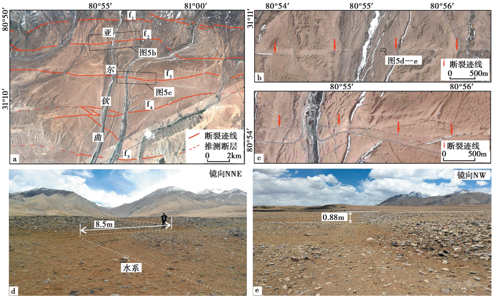
图5 索多村以东段典型部位的断裂展布及断错地貌 a 门士乡东亚尔钦曲一带断裂展布的卫星影像; b 亚尔钦曲两侧f2断裂的迹线; c 亚尔钦曲东f3断裂的迹线; d 亚尔钦曲东侧f2断裂水系右旋位错的照片; e 亚尔钦曲东侧f2断裂断层陡坎的照片
Fig. 5 Typical fault distribution satellite image and faulted landforms of the east Suoduo village section.
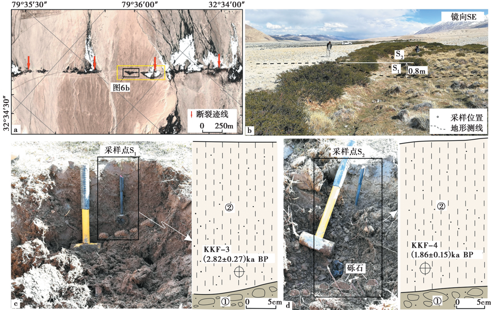
图6 扎西岗乡西断塞塘采样位置(a、 b)及采样剖面图(c、 d)
Fig. 6 Sampling locations(a, b)and profiles(c, d)in sag pond west of Zhaxigang town.
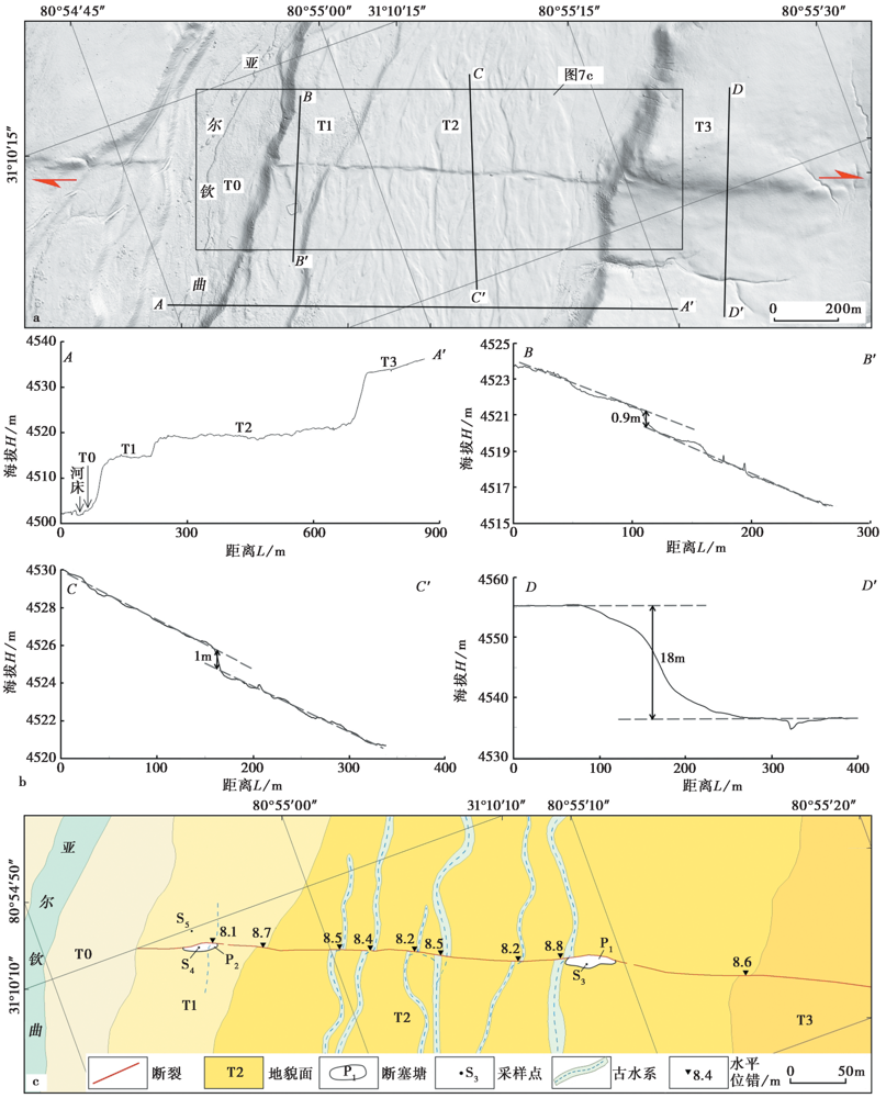
图7 亚尔钦曲东侧断裂沿线的DEM影像(a)、 典型部位的高程测线(b)及地貌面解译(c)
Fig. 7 DEM image(a), typical topographic elevation lines(b), river offset and geomorphic surface interpretation(c)along the fault east of Yaerqin River.
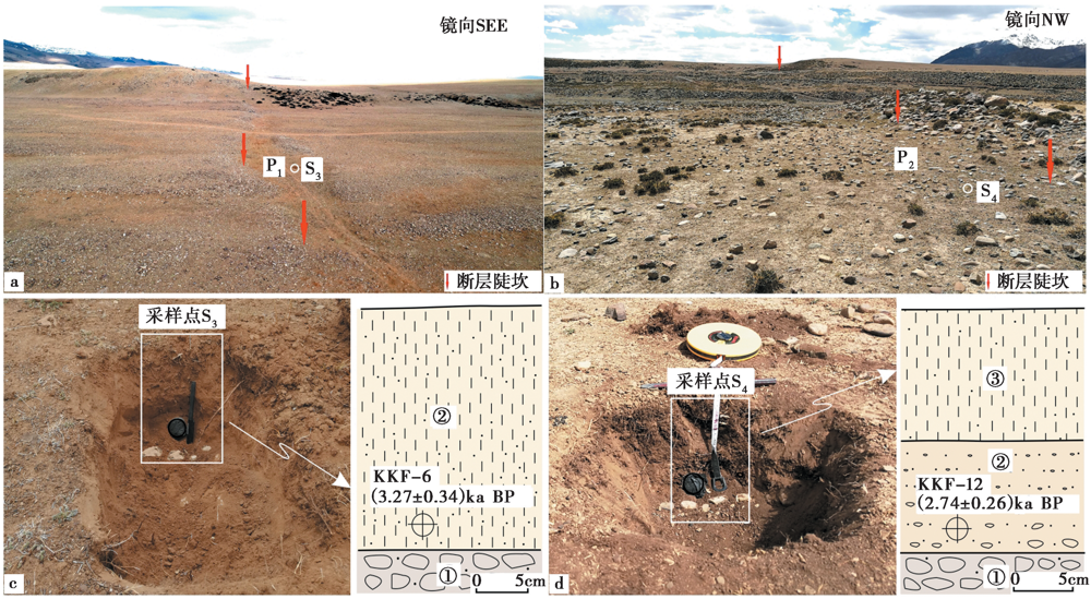
图8 断塞塘P1、 P2内S3、 S4的位置及采样剖面
Fig. 8 Sampling location S3 and S4 in sag pond P1 and P2, and corresponding sampling profiles.
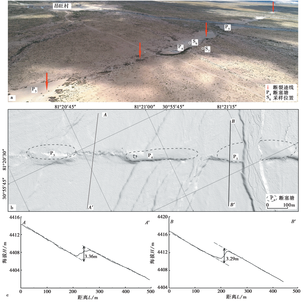
图9 昂旺村南的断裂迹线及断塞塘分布(a)、 DEM影像(b)及典型部位的地形高程测线(c)
Fig. 9 Fault trace and sag pond distribution(a), DEM image(b), and typical topographic elevation line(c)south of Angwang village.
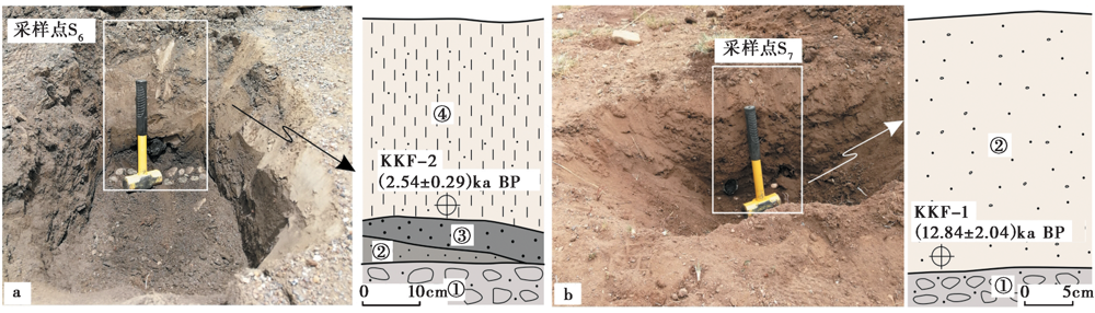
图10 巴嘎乡昂旺村南S6、 S7 2处采样照片及剖面图
Fig. 10 Photos showing the sampling at site S6 and S7, and corresponding sampling profiles.
| 样品编号 | 埋深 /m | U /μg·g-1 | Th /μg·g-1 | K /% | 含水量 /% | 环境剂量率 /Gy·ka-1 | 等效剂量 /Gy | 年龄 /ka |
|---|---|---|---|---|---|---|---|---|
| KKF-1 | 0.28 | 4.04±0.08 | 16.5±0.26 | 3.00±0.02 | 14.09 | 5.83±0.38 | 74.93±10.88 | 12.84±2.04 |
| KKF-2 | 0.34 | 1.7±0.01 | 18.5±0.14 | 2.14±0.01 | 7.39 | 4.84±0.32 | 12.3±1.15 | 2.54±0.29 |
| KKF-3 | 0.21 | 1.67±0.03 | 19.5±0.30 | 2.74±0.01 | 22.86 | 4.74±0.28 | 13.35±1.00 | 2.82±0.27 |
| KKF-4 | 0.24 | 2.36±0.03 | 28.8±0.29 | 2.81±0.01 | 26.37 | 5.59±0.31 | 10.39±0.56 | 1.86±0.15 |
| KKF-6 | 0.18 | 3.38±0.06 | 20.2±0.26 | 2.61±0.01 | 6.37 | 6.09±0.42 | 19.93±1.56 | 3.27±0.34 |
| KKF-11 | 0.25 | 2.26±0.04 | 15.7±0.20 | 1.76±0.01 | 4.93 | 4.51±0.31 | 21.07±1.69 | 4.67±0.49 |
| KKF-12 | 0.17 | 2.27±0.04 | 14±0.16 | 1.67±0.01 | 2.52 | 4.39±0.30 | 12.01±0.78 | 2.74±0.26 |
表1 样品光释光测试参数及年龄
Table 1 OSL test parameters and age of samples
| 样品编号 | 埋深 /m | U /μg·g-1 | Th /μg·g-1 | K /% | 含水量 /% | 环境剂量率 /Gy·ka-1 | 等效剂量 /Gy | 年龄 /ka |
|---|---|---|---|---|---|---|---|---|
| KKF-1 | 0.28 | 4.04±0.08 | 16.5±0.26 | 3.00±0.02 | 14.09 | 5.83±0.38 | 74.93±10.88 | 12.84±2.04 |
| KKF-2 | 0.34 | 1.7±0.01 | 18.5±0.14 | 2.14±0.01 | 7.39 | 4.84±0.32 | 12.3±1.15 | 2.54±0.29 |
| KKF-3 | 0.21 | 1.67±0.03 | 19.5±0.30 | 2.74±0.01 | 22.86 | 4.74±0.28 | 13.35±1.00 | 2.82±0.27 |
| KKF-4 | 0.24 | 2.36±0.03 | 28.8±0.29 | 2.81±0.01 | 26.37 | 5.59±0.31 | 10.39±0.56 | 1.86±0.15 |
| KKF-6 | 0.18 | 3.38±0.06 | 20.2±0.26 | 2.61±0.01 | 6.37 | 6.09±0.42 | 19.93±1.56 | 3.27±0.34 |
| KKF-11 | 0.25 | 2.26±0.04 | 15.7±0.20 | 1.76±0.01 | 4.93 | 4.51±0.31 | 21.07±1.69 | 4.67±0.49 |
| KKF-12 | 0.17 | 2.27±0.04 | 14±0.16 | 1.67±0.01 | 2.52 | 4.39±0.30 | 12.01±0.78 | 2.74±0.26 |
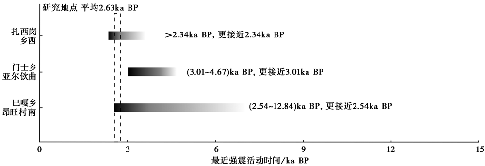
图11 不同部位断裂最近的强震活动时代对比
Fig. 11 Comparison of ages of recent strong earthquake activity in different parts of the fault.
| [1] |
陈杰, 李涛, 李文巧, 等. 2011. 帕米尔构造结及邻区的晚新生代构造与现今变形[J]. 地震地质, 33(2): 241-259. doi: 10.3969/j.issn.0253-4967.2011.02.001.
DOI |
| CHEN Jie, LI Tao, LI Wen-qiao, et al. 2011. Late Cenozoic and present tectonic deformation in the Pamir salient, northwestern China[J]. Seismology and Geology, 33(2): 241-259. (in Chinese) | |
| [2] |
陈杰, 李涛, 孙建宝, 等. 2016. 2016年11月25日新疆阿克陶 MW6.6 地震发震构造与地表破裂[J]. 地震地质, 38(4): 1161-1174. doi: 10.3969/j.issn.0253-4967.2016.04.028.
DOI |
| CHEN Jie, LI Tao, SUN Jian-bao, et al. 2016. Coseismic surface ruptures and seismogenic Muji Fault of the 25 November 2016 Arketao MW6.6 earthquake in northern Pamir[J]. Seismology and Geology, 38(4): 1161-1174. (in Chinese) | |
| [3] | 邓起东. 2005. 活动构造研究及其应用: 谨以此文深切悼念先师陈国达院士[J]. 大地构造与成矿学, 29(1): 17-23. |
| DENG Qi-dong. 2005. Studies and applications of active tectonics: Mourning for Academician CHEN Guo-da, the great master of Chinese geology[J]. Geotectonica et Metallogenia, 29(1): 17-23. (in Chinese) | |
| [4] | 邓起东, 闻学泽. 2008. 活动构造研究: 历史、 进展与建议[J]. 地震地质, 30(1): 1-30. |
| DENG Qi-dong, WEN Xue-ze. 2008. A review on the research of active tectonics: History, progress and suggestions[J]. Seismology and Geology, 30(1): 1-30. (in Chinese) | |
| [5] | 付碧宏, 时丕龙, 贾营营. 2009. 青藏高原大型走滑断裂带晚新生代构造地貌生长及水系响应[J]. 地质科学, 44(4): 1343-1363. |
| FU Bi-hong, SHI Pi-long, JIA Ying-ying. 2009. Late Cenozoic tectono-geomorphic growth and drainage response along the large-scale strike-slip fault system, Tibetan plateau[J]. Chinese Journal of Geology, 44(4): 1343-1363. (in Chinese) | |
| [6] | 顾功叙. 1983. 中国地震目录(公元前1831-公元1969年)[Z]. 北京: 科学出版社. |
| GU Gong-xu. 1983. Catalogue of Chinese Earthquakes(1831BC-1969AD)[Z]. Science Press, Beijing. (in Chinese) | |
| [7] | 雷东宁, 蔡永建, 李媛. 2018. 西藏喀喇昆仑断裂东南段晚第四纪活动的地质地貌特征[J]. 科学技术与工程, 18(32): 152-156. |
| LEI Dong-ning, CAI Yong-jian, LI Yuan. 2018. Geological and topographical features of Karakorum Fault in southeastern segment, western Tibet Plateau at Late Quaternary[J]. Science Technology and Engineering, 18(32): 152-156. (in Chinese) | |
| [8] | 李传友, 张培震, 袁道阳, 等. 2010. 活动走滑断裂上断塞塘沉积特征及其构造含义: 以西秦岭北缘断裂带断塞塘为例[J]. 地质学报, 84(1): 90-105. |
| LI Chuan-you, ZHANG Pei-zhen, YUAN Dao-yang, et al. 2010. Sedimentary characteristics of sag-pond on the active strike-slip fault and its tectonic implications: An example from sag pond along the West Qinling Fault[J]. Acta Geologica Sinica, 84(1): 90-105. (in Chinese) | |
| [9] | 李海兵, Valli F, 刘敦一, 等. 2007. 喀喇昆仑断裂的形成时代: 锆石SHRIMP U-Pb年龄的制约[J]. 科学通报, 52(4): 438-447. |
|
LI Hai-bing, Valli F, LIU Dun-yi, et al. 2007. Initial movement of the Karakorum Fault in western Tibet: Constraints from SHRIMP U-Pb dating of zircons[J]. Chinese Science Bulletin, 52(8): 1089-1100.
DOI URL |
|
| [10] | 李海兵, Valli F, 许志琴, 等. 2006. 喀喇昆仑断裂的变形特征及构造演化[J]. 中国地质, 33(2): 239-255. |
| LI Hai-bing, Valli F, XU Zhi-qin, et al. 2006. Deformation and tectonic evolution of the Karakorum Fault, western Tibet[J]. Geology in China, 33(2): 239-255. (in Chinese) | |
| [11] |
冉勇康, 王虎, 李彦宝, 等. 2012. 中国大陆古地震研究的关键技术与案例解析(1):走滑活动断裂的探槽地点、 布设与事件识别标志[J]. 地震地质, 34(2): 197-210. doi: 10.3969/j.issn.0253-4967.2012.02.001.
DOI |
| RAN Yong-kang, WANG Hu, LI Yan-bao, et al. 2012. Key techniques and several cases analysis in paleoseismic studies in mainland China(1): Trenching sites, layouts and paleoseismic indicators on active strike-slip faults[J]. Seismology and Geology, 34(2): 197-210. (in Chinese) | |
| [12] | 王世锋, 江万, 王超. 2016. 喀喇昆仑断裂沿雅鲁藏布江缝合带活动的构造地貌特征[J]. 地球科学与环境学报, 38(4): 483-493. |
| WANG Shi-feng, JIANG Wan, WANG Chao. 2016. Geomorphic evidence for recent right-lateral shear of Karakorum Fault along Indus-Yalu suture zone of Tibet[J]. Journal of Earth Sciences and Environment, 38(4): 483-493. (in Chinese) | |
| [13] | 许志琴, 李海兵, 杨经绥. 2006. 造山的高原: 青藏高原巨型造山拼贴体和造山类型[J]. 地学前缘, 13(4): 1-17. |
| XU Zhi-qin, LI Hai-bing, YANG Jing-sui. 2006. An orogenic plateau: The orogenic collage and orogenic types of the Qinghai-Tibet plateau[J]. Earth Science Frontiers, 13(4): 1-17. (in Chinese) | |
| [14] | 赵一霖, 刘健, 姜科庆, 等. 2019. 喀喇昆仑断裂北段晚第四纪活动特征及其构造意义[J]. 地球学报, 40(4): 601-613. |
| ZHAO Yi-lin, LIU Jian, JIANG Ke-qing, et al. 2019. Late Quaternary activity characteristics and tectonics significance of the northern Karakorum Fault[J]. Acta Geoscientica Sinica, 40(4): 601-613. (in Chinese) | |
| [15] | 中国地震局震害防御司. 1999. 中国近代地震目录(公元1912-1990年, MS≥4.7)[Z]. 北京. 中国科学技术出版社. |
| Department of Earthquake Disaster Prevention, China Earthquake Administration. 1999. Catalogue of Recent Chinese Earthquakes(1912-1990AD, MS≥4.7)[Z]. China Science and Technology Press, Beijing. (in Chinese) | |
| [16] | Boutonnet E, Leloup P H, Arnaud N, et al. 2012. Synkinematic magmatism, heterogeneous deformation, and progressive strain localization in a strike-slip shear zone: The case of the right-lateral Karakorum Fault[J]. Tectonics, 31(4): TC4012. |
| [17] | Brown E T, Bendick R, Bourlès D L, et al. 2002. Slip rates of the Karakorum Fault, Ladakh, India, determined using cosmic ray exposure dating of debris flows and moraines[J]. Journal of Geophysical Research: Solid Earth, 107(B9): ESE7-1-ESE7-13. |
| [18] | Burtman V S, Molnar P. 1993. Geological and geophysical evidence for deep subduction of continental crust beneath the Pamir [G]. Special Paper of the Geological Society of America, 281: 1-76. |
| [19] | Chevalier M L. 2019. Active tectonics along the Karakorum Fault, western Tibetan plateau: A review[J]. Acta Geoscientica Sinica, 40(1): 37-54. |
| [20] |
Chevalier M L. 2005. Slip-rate measurements on the Karakorum Fault may imply secular variations in fault motion[J]. Science, 307(5708): 411-414.
PMID |
| [21] | Chevalier M L, Li H, Pan J, et al. 2011. Fast slip-rate along the northern end of the Karakorum fault system, western Tibet[J]. Geophysical Research Letters, 38(22): L22309. |
| [22] |
Chevalier M L, Pan J, Li H, et al. 2015. Quantification of both normal and right-lateral late Quaternary activity along the Kongur Shan extensional system, Chinese Pamir[J]. Terra Nova, 27(5): 379-391.
DOI URL |
| [23] | Chevalier M L, Tapponnier P, van der Woerd J, et al. 2012. Spatially constant slip rate along the southern segment of the Karakorum Fault since 200ka[J]. Tectonophysics, 530-531: 152-179. |
| [24] | Chevalier M L, van der Woerd J, Tapponnier P, et al. 2016. Late Quaternary slip-rate along the central Bangong-Chaxikang segment of the Karakorum Fault, western Tibet[J]. Geological Society of America Bulletin, 128(42737): 284-314. |
| [25] |
Cowgill E. 2010. Cenozoic right-slip faulting along the eastern margin of the Pamir salient, northwestern China[J]. Geological Society of America Bulletin, 122(1-2): 145-161.
DOI URL |
| [26] |
Lacassin R, Valli F, Arnaud N, et al. 2004. Large-scale geometry, offset and kinematic evolution of the Karakorum Fault, Tibet[J]. Earth and Planetary Science Letters, 219(3-4): 255-269.
DOI URL |
| [27] |
Matte P, Tapponnier P, Arnaud N, et al. 1996. Tectonics of western Tibet, between the Tarim and the Indus[J]. Earth and Planetary Science Letters, 142(3-4): 311-330.
DOI URL |
| [28] | McCarthy M R, Weinberg R F. 2010. Structural complexity resulting from pervasive ductile deformation in the Karakorum shear zone, Ladakh, NW India[J]. Tectonics, 29(3): TC3004. |
| [29] |
Murphy M A, Burgess W P. 2006. Geometry, kinematics, and landscape characteristics of an active transtension zone, Karakorum fault system, southwest Tibet[J]. Journal of Structural Geology, 28(2): 268-283.
DOI URL |
| [30] |
Murphy M A, Yin A, Kapp P, et al. 2002. Structural evolution of the Gurla Mandhata detachment system, southwest Tibet: Implications for the eastward extent of the Karakorum fault system[J]. Geological Society of America Bulletin, 114(4): 428-447.
DOI URL |
| [31] | Peltzer G, Tapponnier P. 1988. Formation and evolution of strike-slip faults, rifts, and basins during the India-Asia collision: An experimental approach[J]. Journal of Geophysical Research: Solid Earth, 93(B12): 15085-15117. |
| [32] |
Phillips R J, Parrish R R, Searle M P. 2004. Age constraints on ductile deformation and long-term slip rates along the Karakorum fault zone, Ladakh[J]. Earth and Planetary Science Letters, 226(3-4): 305-319.
DOI URL |
| [33] |
Robinson A C. 2009. Evidence against Quaternary slip on the northern Karakorum Fault suggests kinematic reorganization at the western end of the Himalayan-Tibetan orogen[J]. Earth and Planetary Science Letters, 286(1-2): 158-170.
DOI URL |
| [34] | Robinson A C, Owen L A, Chen J, et al. 2015. No late Quaternary strike-slip motion along the northern Karakoram Fault[J]. Earth and Planetary Science Letters, 49: 290-298. |
| [35] |
Robinson A C, Yin A, Manning C E, et al. 2007. Cenozoic evolution of the eastern Pamir: Implications for strain-accommodation mechanisms at the western end of the Himalayan-Tibetan orogen[J]. Geological Society of America Bulletin, 119(7-8): 882-896.
DOI URL |
| [36] |
Rolland Y, Mahéo G, Pêcher A, et al. 2009. Syn-kinematic emplacement of the Pangong metamorphic and magmatic complex along the Karakorum Fault(N Ladakh)[J]. Journal of Asian Earth Sciences, 34(1): 10-25.
DOI URL |
| [37] | Valli F, Arnaud N, Leloup P H, et al. 2007. Twenty million years of continuous deformation along the Karakorum Fault, western Tibet: A thermochronological analysis[J]. Tectonics, 26(4): TC4004. |
| [38] | Valli F, Leloup P H, Paquette J L, et al. 2008. New U-Th/Pb constraints on timing of shearing and long-term slip-rate on the Karakorum Fault[J]. Tectonics, 27(5): TC5007. |
| [39] |
Wallace R E 1970. Earthquake recurrence intervals on the San Andreas Fault[J]. Geological Society of America Bulletin, 81(10): 2875-2890.
DOI URL |
| [40] |
Wright T J, Parsons B, England P C, et al. 2004. InSAR observations of low slip rates on the major faults of western Tibet[J]. Science, 305(5681): 236-239.
PMID |
| [41] |
Zhou Y, Ronghua X U, Yan Y, et al. 2001. Dating of the Karakorum strike-slip fault[J]. Acta Geologica Sinica, 75(1): 10-18.
DOI URL |
| [1] | 刘庆, 刘韶, 张世民. 大凉山断裂带中段越西断裂晚第四纪古地震[J]. 地震地质, 2023, 45(2): 321-337. |
| [2] | 左玉琦, 杨海波, 杨晓平, 詹艳, 李安, 孙翔宇, 胡宗凯. 阿拉善地块南缘北大山断裂的晚第四纪构造活动证据[J]. 地震地质, 2023, 45(2): 355-376. |
| [3] | 原浩东, 李安, 黄伟亮, 胡宗凯, 左玉琦, 杨晓平. 西准噶尔地区托里断裂晚第四纪构造变形[J]. 地震地质, 2023, 45(1): 49-66. |
| [4] | 张伟恒, 陈杰, 李涛, 邸宁, 姚远. 龙门山前陆冲断带南段三苏场背斜晚第四纪变形速率[J]. 地震地质, 2022, 44(6): 1351-1364. |
| [5] | 冯晶晶, 赵勇伟, 李霓, 陈正全, 王丽竹, 刘永顺, 聂保锋, 张学斌. 琼北晚第四纪火山锥体形貌与喷发机制[J]. 地震地质, 2022, 44(5): 1107-1127. |
| [6] | 沈军, 戴训也, 肖淳, 焦轩凯, 白其乐格尔, 邓梅, 刘泽众, 夏方华, 刘玉, 刘明. 夏垫西断裂的晚第四纪活动性[J]. 地震地质, 2022, 44(4): 909-924. |
| [7] | 张驰, 李智敏, 任治坤, 刘金瑞, 张志亮, 武登云. 日月山断裂南段晚第四纪活动特征[J]. 地震地质, 2022, 44(1): 1-19. |
| [8] | 常昊, 常祖峰, 刘昌伟. 金沙江断裂带活动与大型滑坡群的关系研究:以金沙江拿荣—绒学段为例[J]. 地震地质, 2021, 43(6): 1435-1458. |
| [9] | 杨晨艺, 李晓妮, 冯希杰, 朱琳, 李苗, 张恩会. 渭河盆地北缘口镇-关山断层的晚第四纪—现今的活动性[J]. 地震地质, 2021, 43(3): 504-520. |
| [10] | 梁明剑, 杨耀, 杜方, 宫悦, 孙玮, 赵敏, 何强. 青海达日断裂中段晚第四纪活动性与1947年M73/4地震地表破裂带再研究[J]. 地震地质, 2020, 42(3): 703-714. |
| [11] | 唐清, 郑文俊, 石霖, 张冬丽, 黄荣. 基于高精度LiDAR数据的断裂活动习性精细定量——以香山-天景山断裂景泰小红山段为例[J]. 地震地质, 2020, 42(2): 366-381. |
| [12] | 梁明剑, 陈立春, 冉勇康, 李彦宝, 王栋, 高帅坡, 韩明明, 曾蒂. 鲜水河断裂带雅拉河段晚第四纪活动性[J]. 地震地质, 2020, 42(2): 513-525. |
| [13] | 李彦宝, 陈立春, 王虎, 曾蒂, 刘成龙. 雅鲁藏布江断裂带昂仁段晚第四纪活动证据[J]. 地震地质, 2019, 41(5): 1091-1104. |
| [14] | 李光涛, 苏刚, 程理, 李峰, 吴昊. 中甸-大具断裂南东段晚第四纪活动的地质地貌证据[J]. 地震地质, 2019, 41(3): 545-560. |
| [15] | 艾明, 毕海芸, 郑文俊, 尹金辉, 袁道阳, 任治坤, 陈干, 刘金瑞. 利用无人机摄影测量技术提取活动构造定量参数[J]. 地震地质, 2018, 40(6): 1276-1293. |
| 阅读次数 | ||||||
|
全文 |
|
|||||
|
摘要 |
|
|||||
