地震地质 ›› 2022, Vol. 44 ›› Issue (5): 1107-1127.DOI: 10.3969/j.issn.0253-4967.2022.05.002
冯晶晶1),2)( ), 赵勇伟1),*(), 李霓1), 陈正全1), 王丽竹1), 刘永顺2), 聂保锋2), 张学斌3)
收稿日期:2021-08-25
修回日期:2021-10-19
出版日期:2022-10-20
发布日期:2022-11-28
通讯作者:
赵勇伟
作者简介:冯晶晶, 女, 1996年生, 2018年于河北地质大学获得理学学士学位, 现为首都师范大学与中国地震局地质研究所联合培养自然地理学专业在读硕士研究生, 研究方向为自然地理学, E-mail: 18732172375@163.com。
基金资助:
FENG Jing-jing1),2)(), ZHAO Yong-wei1)(), LI Ni1), CHEN Zheng-quan1), WANG Li-zhu1), LIU Yong-shun2), NIE Bao-feng2), ZHANG Xue-bin3)
Received:2021-08-25
Revised:2021-10-19
Online:2022-10-20
Published:2022-11-28
Contact:
ZHAO Yong-wei
摘要:
文中以琼北峨蔓、 海口等地200ka以来喷发形成的38座火山为研究对象, 基于Google Earth高分辨率遥感卫星影像及ALSO(12.5m)数字高程模型(DEM)数据, 并基于无人机倾斜摄影测量生成的高精度、 高分辨率数字正射像图(DOM)和数字高程模型(DEM)数据, 详细测量了锥体形态, 对其形态进行定性和定量研究。文中提出了一种新的方法: “Scoh(火山锥水平截面积)-Hh(锥体山顶至截面垂直距离)法”, 可精确分析琼北锥体形态上的差异。研究表明, 在Scoh-Hh投图中, 根据曲线的不同, 火山锥体总体可分为3类: 1)曲线坡度较小, Average(Hh/Scoh)h>3m=0~0.6, 区内约有22%的锥体属于该类型; 2)曲线坡度较陡, Average(Hh/Scoh)h>3m=1.0~6.0, 区内约有65%的锥体属于该类型; 3)曲线坡度最陡, Average(Hh/Scoh)h>3m=4.0~12.0, 区内约有13%的锥体属于该类型。野外地质调查证实, 第1类火山锥以罗经盘为代表, 由火山砾、 火山灰、 围岩碎屑构成, 具有平行层理, 属于凝灰岩环(tuff ring)型锥体, 为射汽岩浆喷发(phreatomagmatic erutpion)成因。第2类火山锥以马鞍岭为代表, 由火山弹、 熔岩饼等岩浆爆破成因的火山碎屑组成, 属斯通博利型(Strombolian)-夏威夷型(Hawaii)火山喷发成因。第3类火山锥以笔架岭火山为代表, 多由直径>30cm的熔岩块构成, 推测为侵出成因(extrusion)。研究表明, 不同喷发类型形成的火山锥具有不同的形态特征, 这些形态差异可以准确地反映在Scoh-Hh曲线中。因此, 利用该方法基于火山锥高精度DEM数据可能能够限定火山喷发的类型, 这对于高效统计确定大型火山群的喷发类型、 评估火山喷发灾害类型和灾害预期提供了一个新的研究思路。
冯晶晶, 赵勇伟, 李霓, 陈正全, 王丽竹, 刘永顺, 聂保锋, 张学斌. 琼北晚第四纪火山锥体形貌与喷发机制[J]. 地震地质, 2022, 44(5): 1107-1127.
FENG Jing-jing, ZHAO Yong-wei, LI Ni, CHEN Zheng-quan, WANG Li-zhu, LIU Yong-shun, NIE Bao-feng, ZHANG Xue-bin. CONE MORPHOLOGY AND ERUPTION MECHANISMS OF THE LATE QUATERNARY VOLCANO IN NORTHERN HAINAN ISLAND[J]. SEISMOLOGY AND GEOLOGY, 2022, 44(5): 1107-1127.
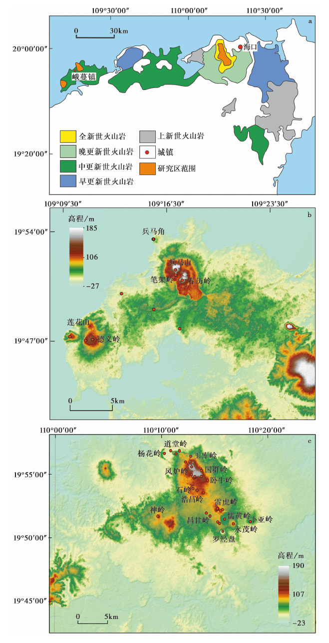
图1 琼北火山区的地质图及火山群分布特征 a 琼北新生代火山岩分布图(据刘建强等(2013)修改); b 峨蔓地区火山分布图; c 海口地区火山分布图
Fig. 1 Geological map of the Qiongbei volcanic field and distribution characteristics of the volcanic swarm.
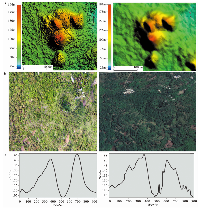
图2 不同数据源的火山锥体形态对比图 a 1︰ 2 000比例尺下SfM-DEM与ALSO-DEM的细节对比图; b SfM-DOM图与Google Earth影像中马鞍岭地区的对比图; c 在SfM-DEM与ALSO-DEM数据中雷虎岭同一剖面的对比图
Fig. 2 Comparison of volcanic cone shapes from different data sources.
| 火山名称 | 地点 | 坐标 | 时代 | 类型 | Wcoa/m | Wcob/m | Hco/m | Wcr | Hco/Wco | Wcr/Wco | 火口数 | 火口破裂 方向/(°) | 平均坡度 /(°) |
|---|---|---|---|---|---|---|---|---|---|---|---|---|---|
| 雷虎岭 | 海口永兴 | 19°52'21″N, 110°15'18″E | 全新世 | 混合锥 | 865 | 820 | 49 | 294 | 0.06 | 0.34 | 1 | 58 | 12 |
| 群众岭 | 海口永兴 | 19°52'13″N, 110°15'34″E | 晚更新世 | 混合锥 | 340 | 278 | 21 | 0.06 | 1 | 222 | 5 | ||
| 群修岭 | 海口永兴 | 19°52'29″N, 110°15'11″E | 晚更新世 | 混合锥 | 274 | 223 | 15 | 0.05 | 1 | 312 | 12 | ||
| 罗经盘 | 海口永兴 | 19°50'34″N, 110°15'48″E | 晚更新世 | 低平火山口 | 1 066 | 1 012 | 39 | 553 | 0.04 | 0.60 | 1 | ||
| 永茂岭 | 海口永兴 | 19°51'11″N, 110°16'47″E | 晚更新世 | 熔岩锥 | 1 164 | 1 062 | 30 | 0.03 | 1 | 77 | 10 | ||
| 群香岭 | 海口永兴 | 19°51'19″N, 110°15'21″E | 晚更新世 | 碎屑锥 | 365 | 258 | 13 | 145 | 0.04 | 0.40 | 1 | 57 | 26 |
| 谷墩岭 | 海口永兴 | 19°51'12″N, 110°15'30″E | 晚更新世 | 碎屑锥 | 327 | 282 | 10 | 0.03 | 1 | 111 | |||
| 卧牛岭 | 海口永兴 | 19°54'36″N, 110°14'19″E | 晚更新世 | 混合锥 | 235 | 174 | 14 | 63 | 0.06 | 0.27 | 1 | ||
| 群仙岭 | 海口永兴 | 19°52'01″N, 110°14'15″E | 晚更新世 | 混合锥 | 136 | 118 | 4 | 0.03 | 1 | ||||
| 昌甘岭 | 海口永兴 | 19°51'47″N, 110°14'36″E | 晚更新世 | 混合锥 | 240 | 143 | 6 | 0.03 | 1 | ||||
| 卜亚岭 | 海口永兴 | 19°51'21″N, 110°18'23″E | 晚更新世 | 熔岩锥 | 984 | 830 | 23 | 0.02 | 1 | 30 | |||
| 儒黄岭 | 海口永兴 | 19°51'32″N, 110°15'58″E | 晚更新世 | 低平火山口 | 1 828 | 1 801 | 20 | 1 366 | 0.01 | 0.75 | 1 | 43 | |
| 那墩岭 | 海口石山 | 19°53'37″N, 110°13'58″E | 晚更新世 | 混合锥 | 342 | 319 | 11 | 0.03 | 1 | 87 | 4 | ||
| 儒群岭 | 海口石山 | 19°53'52″N, 110°13'55″E | 晚更新世 | 混合锥 | 181 | 162 | 5 | 65 | 0.03 | 0.36 | 1 | 315 | |
| 浩昌岭 | 海口石山 | 19°53'48″N, 110°13'22″E | 晚更新世 | 混合锥 | 256 | 190 | 10 | 0.04 | 1 | 156 | |||
| 美社岭 | 海口石山 | 19°55'22″N, 110°13'11″E | 晚更新世 | 碎屑锥 | 538 | 347 | 48 | 127 | 0.09 | 0.24 | 1 | 285 | |
| 昌道岭 | 海口石山 | 19°54'53″N, 110°13'09″E | 晚更新世 | 碎屑锥 | 413 | 377 | 31 | 162 | 0.08 | 0.39 | 1 | 160 | |
| 双池岭 | 海口石山 | 19°56'46″N, 110°11'15″E | 晚更新世 | 低平火山口 | 520 | 152 | 19 | 0.04 | 1 | 157 | 18 | ||
| 道堂岭 | 海口石山 | 19°56'53″N, 110°10'36″E | 晚更新世 | 碎屑锥 | 677 | 565 | 8 | 0.01 | 1 | 6 | |||
| 阳南岭 | 海口石山 | 19°54'52″N, 110°13'36″E | 晚更新世 | 碎屑锥 | 218 | 178 | 13 | 0.06 | 1 | 338 | |||
| 石岭 | 海口石山 | 19°56'44″N, 110°15'03″E | 晚更新世 | 低平火山口 | 1 302 | 1 133 | 32 | 0.02 | 1 | 290 | |||
| 吉安岭 | 海口石山 | 19°56'42″N, 110°11'48″E | 晚更新世 | 多重火山锥 | 650 | 534 | 29 | 0.04 | 1(2) | 38 | |||
| 杨花岭 | 海口石山 | 19°56'42″N, 110°10'24″E | 晚更新世 | 低平火山口 | 1 656 | 1 509 | 38 | 0.02 | 1 | 72 | |||
| 儒才岭 | 海口石山 | 19°56'02″N, 110°12'16″E | 晚更新世 | 碎屑锥 | 167 | 142 | 10 | 0.06 | 1 | ||||
| 包子岭 | 海口石山 | 19°55'55″N, 110°12'48″E | 晚更新世 | 碎屑锥 | 338 | 323 | 45 | 50 | 0.13 | 0.15 | 1 | ||
| 风炉岭 | 海口石山 | 19°55'39″N, 110°12'51″E | 全新世 | 多重火山锥 | 589 | 534 | 55 | 94 | 0.09 | 0.16 | 1 | 155 | 30 |
| 国群岭A | 海口石山 | 19°55'31″N, 110°13'45″E | 晚更新世 | 碎屑锥 | 316 | 270 | 21 | 0.07 | 1(2) | 214 | |||
| 国群岭B | 海口石山 | 19°55'20″N, 110°13'45″E | 晚更新世 | 碎屑锥 | 248 | 209 | 22 | 0.09 | 1 | 131 | |||
| 神岭 | 海口石山 | 19°51'47″N, 110°09'40″E | 晚更新世 | 碎屑锥 | 703 | 686 | 27 | 0.04 | 1 | 72 | |||
| 玉库岭 | 海口石山 | 19°56'41″N, 110°12'19″E | 晚更新世 | 碎屑锥 | 431 | 372 | 17 | 0.04 | 1 | ||||
| 德义岭 | 海口儋州 | 19°47'09″N, 109°11'36″E | 晚更新世 | 熔岩锥 | 1 722 | 1 582 | 47 | 0.03 | 1 | 95 | |||
| 莲花岭 | 海口儋州 | 19°47'21″N, 109°10'16″E | 晚更新世 | 熔岩锥 | 911 | 714 | 28 | 0.03 | 1 | 195 | |||
| 春历岭 | 海口儋州 | 19°50'59″N, 109°17'41″E | 晚更新世 | 碎屑锥 | 754 | 428 | 68 | 0.09 | 1 | 45 | |||
| 笔架岭A | 海口儋州 | 19°51'25″N, 109°17'15″E | 晚更新世 | 混合锥 | 426 | 418 | 43 | 0.10 | 1 | ||||
| 笔架岭B | 海口儋州 | 19°51'38″N, 109°17'13″E | 晚更新世 | 混合锥 | 576 | 444 | 90 | 0.16 | 1 | ||||
| 笔架岭C | 海口儋州 | 19°51'48″N, 109°17'13″E | 晚更新世 | 混合锥 | 348 | 300 | 70 | 0.20 | 1 | ||||
| 笔架岭D | 海口儋州 | 19°51'52″N, 109°17'19″E | 晚更新世 | 混合锥 | 401 | 224 | 50 | 0.12 | 1 | ||||
| 笔架岭E | 海口儋州 | 19°51'52″N, 109°17'17″E | 晚更新世 | 混合锥 | 418 | 348 | 70 | 0.17 | 1 |
表1 研究区的火山参数表
Table1 Parameters of volcanoes in the study area
| 火山名称 | 地点 | 坐标 | 时代 | 类型 | Wcoa/m | Wcob/m | Hco/m | Wcr | Hco/Wco | Wcr/Wco | 火口数 | 火口破裂 方向/(°) | 平均坡度 /(°) |
|---|---|---|---|---|---|---|---|---|---|---|---|---|---|
| 雷虎岭 | 海口永兴 | 19°52'21″N, 110°15'18″E | 全新世 | 混合锥 | 865 | 820 | 49 | 294 | 0.06 | 0.34 | 1 | 58 | 12 |
| 群众岭 | 海口永兴 | 19°52'13″N, 110°15'34″E | 晚更新世 | 混合锥 | 340 | 278 | 21 | 0.06 | 1 | 222 | 5 | ||
| 群修岭 | 海口永兴 | 19°52'29″N, 110°15'11″E | 晚更新世 | 混合锥 | 274 | 223 | 15 | 0.05 | 1 | 312 | 12 | ||
| 罗经盘 | 海口永兴 | 19°50'34″N, 110°15'48″E | 晚更新世 | 低平火山口 | 1 066 | 1 012 | 39 | 553 | 0.04 | 0.60 | 1 | ||
| 永茂岭 | 海口永兴 | 19°51'11″N, 110°16'47″E | 晚更新世 | 熔岩锥 | 1 164 | 1 062 | 30 | 0.03 | 1 | 77 | 10 | ||
| 群香岭 | 海口永兴 | 19°51'19″N, 110°15'21″E | 晚更新世 | 碎屑锥 | 365 | 258 | 13 | 145 | 0.04 | 0.40 | 1 | 57 | 26 |
| 谷墩岭 | 海口永兴 | 19°51'12″N, 110°15'30″E | 晚更新世 | 碎屑锥 | 327 | 282 | 10 | 0.03 | 1 | 111 | |||
| 卧牛岭 | 海口永兴 | 19°54'36″N, 110°14'19″E | 晚更新世 | 混合锥 | 235 | 174 | 14 | 63 | 0.06 | 0.27 | 1 | ||
| 群仙岭 | 海口永兴 | 19°52'01″N, 110°14'15″E | 晚更新世 | 混合锥 | 136 | 118 | 4 | 0.03 | 1 | ||||
| 昌甘岭 | 海口永兴 | 19°51'47″N, 110°14'36″E | 晚更新世 | 混合锥 | 240 | 143 | 6 | 0.03 | 1 | ||||
| 卜亚岭 | 海口永兴 | 19°51'21″N, 110°18'23″E | 晚更新世 | 熔岩锥 | 984 | 830 | 23 | 0.02 | 1 | 30 | |||
| 儒黄岭 | 海口永兴 | 19°51'32″N, 110°15'58″E | 晚更新世 | 低平火山口 | 1 828 | 1 801 | 20 | 1 366 | 0.01 | 0.75 | 1 | 43 | |
| 那墩岭 | 海口石山 | 19°53'37″N, 110°13'58″E | 晚更新世 | 混合锥 | 342 | 319 | 11 | 0.03 | 1 | 87 | 4 | ||
| 儒群岭 | 海口石山 | 19°53'52″N, 110°13'55″E | 晚更新世 | 混合锥 | 181 | 162 | 5 | 65 | 0.03 | 0.36 | 1 | 315 | |
| 浩昌岭 | 海口石山 | 19°53'48″N, 110°13'22″E | 晚更新世 | 混合锥 | 256 | 190 | 10 | 0.04 | 1 | 156 | |||
| 美社岭 | 海口石山 | 19°55'22″N, 110°13'11″E | 晚更新世 | 碎屑锥 | 538 | 347 | 48 | 127 | 0.09 | 0.24 | 1 | 285 | |
| 昌道岭 | 海口石山 | 19°54'53″N, 110°13'09″E | 晚更新世 | 碎屑锥 | 413 | 377 | 31 | 162 | 0.08 | 0.39 | 1 | 160 | |
| 双池岭 | 海口石山 | 19°56'46″N, 110°11'15″E | 晚更新世 | 低平火山口 | 520 | 152 | 19 | 0.04 | 1 | 157 | 18 | ||
| 道堂岭 | 海口石山 | 19°56'53″N, 110°10'36″E | 晚更新世 | 碎屑锥 | 677 | 565 | 8 | 0.01 | 1 | 6 | |||
| 阳南岭 | 海口石山 | 19°54'52″N, 110°13'36″E | 晚更新世 | 碎屑锥 | 218 | 178 | 13 | 0.06 | 1 | 338 | |||
| 石岭 | 海口石山 | 19°56'44″N, 110°15'03″E | 晚更新世 | 低平火山口 | 1 302 | 1 133 | 32 | 0.02 | 1 | 290 | |||
| 吉安岭 | 海口石山 | 19°56'42″N, 110°11'48″E | 晚更新世 | 多重火山锥 | 650 | 534 | 29 | 0.04 | 1(2) | 38 | |||
| 杨花岭 | 海口石山 | 19°56'42″N, 110°10'24″E | 晚更新世 | 低平火山口 | 1 656 | 1 509 | 38 | 0.02 | 1 | 72 | |||
| 儒才岭 | 海口石山 | 19°56'02″N, 110°12'16″E | 晚更新世 | 碎屑锥 | 167 | 142 | 10 | 0.06 | 1 | ||||
| 包子岭 | 海口石山 | 19°55'55″N, 110°12'48″E | 晚更新世 | 碎屑锥 | 338 | 323 | 45 | 50 | 0.13 | 0.15 | 1 | ||
| 风炉岭 | 海口石山 | 19°55'39″N, 110°12'51″E | 全新世 | 多重火山锥 | 589 | 534 | 55 | 94 | 0.09 | 0.16 | 1 | 155 | 30 |
| 国群岭A | 海口石山 | 19°55'31″N, 110°13'45″E | 晚更新世 | 碎屑锥 | 316 | 270 | 21 | 0.07 | 1(2) | 214 | |||
| 国群岭B | 海口石山 | 19°55'20″N, 110°13'45″E | 晚更新世 | 碎屑锥 | 248 | 209 | 22 | 0.09 | 1 | 131 | |||
| 神岭 | 海口石山 | 19°51'47″N, 110°09'40″E | 晚更新世 | 碎屑锥 | 703 | 686 | 27 | 0.04 | 1 | 72 | |||
| 玉库岭 | 海口石山 | 19°56'41″N, 110°12'19″E | 晚更新世 | 碎屑锥 | 431 | 372 | 17 | 0.04 | 1 | ||||
| 德义岭 | 海口儋州 | 19°47'09″N, 109°11'36″E | 晚更新世 | 熔岩锥 | 1 722 | 1 582 | 47 | 0.03 | 1 | 95 | |||
| 莲花岭 | 海口儋州 | 19°47'21″N, 109°10'16″E | 晚更新世 | 熔岩锥 | 911 | 714 | 28 | 0.03 | 1 | 195 | |||
| 春历岭 | 海口儋州 | 19°50'59″N, 109°17'41″E | 晚更新世 | 碎屑锥 | 754 | 428 | 68 | 0.09 | 1 | 45 | |||
| 笔架岭A | 海口儋州 | 19°51'25″N, 109°17'15″E | 晚更新世 | 混合锥 | 426 | 418 | 43 | 0.10 | 1 | ||||
| 笔架岭B | 海口儋州 | 19°51'38″N, 109°17'13″E | 晚更新世 | 混合锥 | 576 | 444 | 90 | 0.16 | 1 | ||||
| 笔架岭C | 海口儋州 | 19°51'48″N, 109°17'13″E | 晚更新世 | 混合锥 | 348 | 300 | 70 | 0.20 | 1 | ||||
| 笔架岭D | 海口儋州 | 19°51'52″N, 109°17'19″E | 晚更新世 | 混合锥 | 401 | 224 | 50 | 0.12 | 1 | ||||
| 笔架岭E | 海口儋州 | 19°51'52″N, 109°17'17″E | 晚更新世 | 混合锥 | 418 | 348 | 70 | 0.17 | 1 |
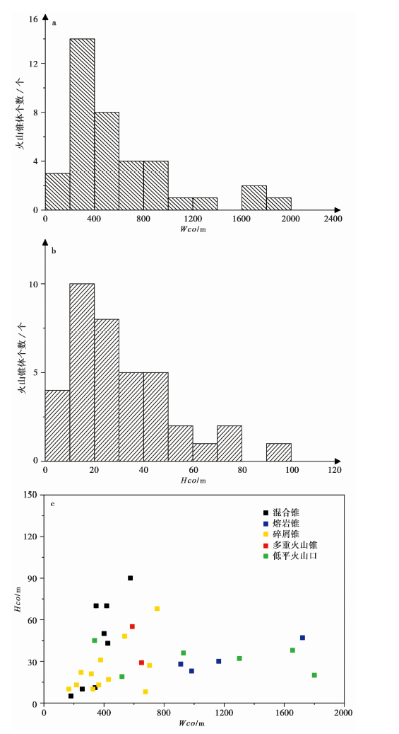
图3 火山锥体锥高(Hco)与底径(Wco)的分析对比图 a 基底直径(Wco)的统计柱状图; b 锥高(Hco)的统计柱状图; c 不同类型火山锥体的锥高/底径(Hco/Wco)分布图
Fig. 3 Comparative analysis of cone height(Hco)and base diameter(Wco)of volcanic cone.
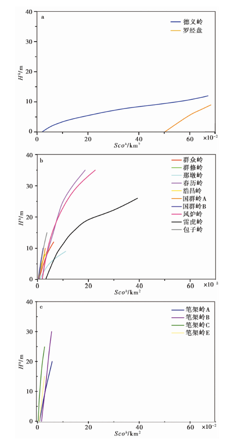
图4 不同类型火山锥体的Scoh-Hh图 a 第1类; b 第2类; c 第3类
Fig. 4 Scoh-Hh diagram of different types of volcanic cones.
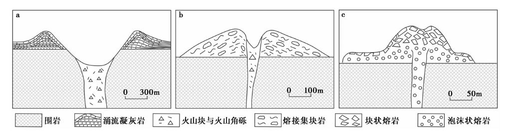
图5 3种不同喷发成因的火山锥体结构简图 a 射汽岩浆成因; b 岩浆爆破成因(夏威夷式); c 侵出成因
Fig. 5 Schematic diagram of volcanic cone structure with three different eruption cause.
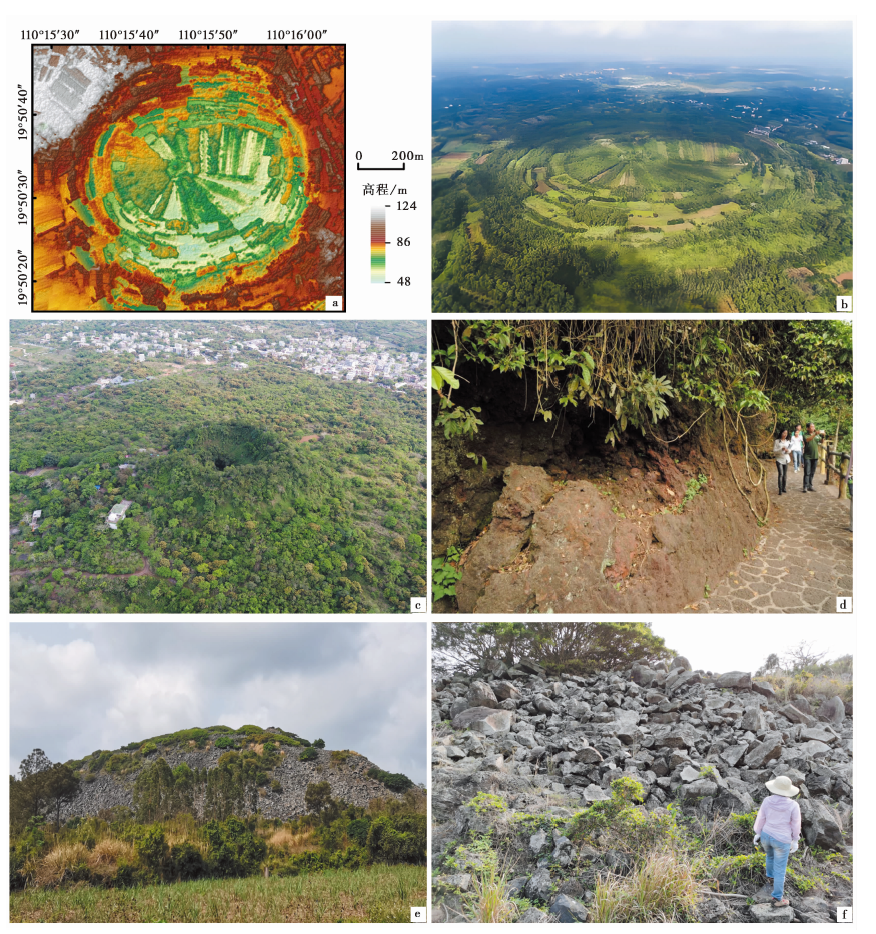
图6 琼北第四纪火山的地质地貌特征图 a 罗经盘火山口地形(DEM)的渲染图; b 罗经盘火山口; c 马鞍岭火山锥体; d 马鞍岭火山口内壁溅落成因的熔结集块岩;e 笔架岭锥体剖面; f 笔架岭堆积的块状熔岩
Fig. 6 Geological and geomorphological characteristics of the Qiongbei Quaternary volcanoes.
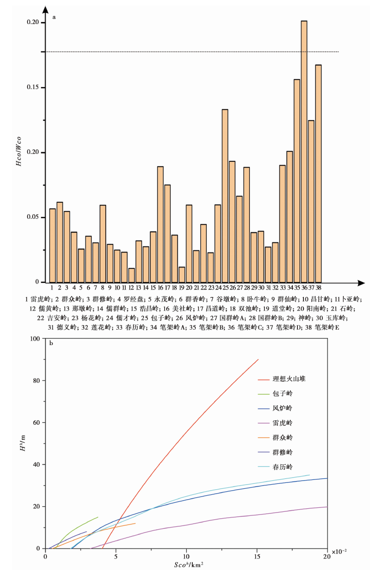
图7 琼北地区火山渣锥与理想火山渣锥的对比图 a 火山渣锥与理想火山渣锥的Hco/Wco图; b 火山渣锥与理想火山渣锥的Scoh-Hh图
Fig. 7 Comparative map of volcanic cinder cones and perfect volcanic cinder cones in Qiongbei area.
| [1] |
白志达, 徐德斌, 魏海泉, 等. 2003. 琼北马鞍岭地区第四纪火山活动期次划分[J]. 地震地质, 25(S1): 12-20.
|
|
|
|
| [2] |
段政, 张翔, 周翠, 等. 2021. 琼北地区第四纪火山地质遗迹类型与地学意义[J]. 地球学报, 42(1): 111-123.
|
|
|
|
| [3] |
樊祺诚, 孙谦, 李霓, 等. 2004. 琼北火山活动分期与全新世岩浆演化[J]. 岩石学报, 20(3): 533-544.
|
|
|
|
| [4] |
付建明. 1997. 琼北新生代火山作用与构造环境[J]. 桂林工学院学报, 17(1): 27-34.
|
|
|
|
| [5] |
符启基, 沈金羽, 林才. 2012. 海南省笔架岭火山口及峨蔓湾地质遗迹景观开发初探[J]. 资源环境与工程, 26(6): 641-644.
|
|
|
|
| [6] |
葛同明, 陈文寄, 徐行, 等. 1989. 雷琼地区第四纪地磁极性年表火山岩钾-氩年龄及古地磁学证据[J]. 地球物理学报, 32(5): 550-558.
|
|
|
|
| [7] |
韩中元, 张仲英, 刘瑞华, 等. 1987. 海南岛北部火山地貌[J]. 热带地理, 7(1): 43-53.
|
|
|
|
| [8] |
黄镇国, 蔡福祥, 韩中元, 等. 1993. 雷琼第四纪火山[M]. 北京: 科学出版社.
|
|
|
|
| [9] |
黄镇国, 蔡福祥. 1994. 雷琼第四纪火山活动的新认识[J]. 热带地理, 14(1): 1-10.
|
|
|
|
| [10] |
黄镇国, 张伟强, 陈俊鸿. 1995. 我国第四纪火山活动的板块构造背景[J]. 地理科学, 15(2): 109-117.
|
|
DOI |
|
| [11] |
刘嘉麒,
|
|
|
|
| [12] |
刘建强, 任钟元. 2013. 玄武岩源区母岩的多样性和识别特征: 以海南岛玄武岩为例[J]. 大地构造与成矿学, 37(3): 471-488.
|
|
|
|
| [13] |
洒骁, 季建清, 周晶. 2013. 琼北火山岩激光“40Ar/39Ar”定年研究[J]. 岩石学报, 29(8): 2789-2795.
|
|
|
|
| [14] |
申立新. 1989. 琼北第四纪地质演化特征[J]. 河北地质学院学报, 12(2): 183-190.
|
|
|
|
| [15] |
史兰斌, 林传勇, 陈孝德, 等. 2003. 琼北第四纪玄武岩中微型地幔岩捕虏体的发现及其意义[J]. 地震地质, 25(S1): 33-42.
|
|
|
|
| [16] |
孙谦, 樊祺诚. 2005. 琼北射气岩浆喷发力学机制探讨[J]. 地震地质, 27(1): 63-72.
|
|
|
|
| [17] |
孙稳, 何宏林, 魏占玉, 等. 2019. 基于无人机航测获取高分辨率 DEM 数据的断层几何结构精细解译与分析--以海原断裂唐家坡为例[J]. 地震地质, 41(6): 1350-1365.
|
|
|
|
| [18] |
陶奎元. 2007. 中国雷琼世界地质公园[J]. 资源调查与环境, 28(3): 223-228.
|
|
|
|
| [19] |
魏海泉, 白志达, 胡久常, 等. 2003. 琼北全新世火山区火山系统的划分与锥体结构参数研究[J]. 地震地质, 25(S1): 21-32.
|
|
|
|
| [20] |
魏占玉,
|
|
|
|
| [21] |
闫成国, 张文朋. 2013. 第四纪火山活动典型地区地震活动特征研究[J]. 防灾减灾学报, 29(1): 13-24.
|
|
|
|
| [22] |
赵勇伟, 樊祺诚, 李霓, 等. 2018. 内蒙古达里诺尔晚新生代火山群喷发特征研究[J]. 岩石学报, 34(1): 103-112.
|
|
|
|
| [23] |
朱炳泉, 王惠芬. 1989. 雷琼地区MORB-OIB 过渡型地幔源火山作用的 Nb-Sr-Pb 同位素证据[J]. 地球化学, 20(3): 193-201.
|
|
DOI URL |
|
| [24] |
邹和平, 黄玉昆. 1987. 琼北新生代坳陷构造特征及其演化[J]. 大地构造与成矿学, 11(1): 33-46.
|
|
|
|
| [25] |
DOI URL |
| [26] |
DOI URL |
| [27] |
|
| [28] |
DOI URL |
| [29] |
|
| [30] |
|
| [31] |
DOI URL |
| [32] |
DOI URL |
| [33] |
DOI URL |
| [34] |
DOI URL |
| [35] |
DOI URL |
| [36] |
|
| [37] |
DOI URL |
| [38] |
|
| [39] |
|
| [40] |
DOI URL |
| [41] |
DOI URL |
| [42] |
DOI URL |
| [43] |
DOI URL |
| [44] |
DOI URL |
| [45] |
|
| [46] |
|
| [47] |
|
| [48] |
DOI URL |
| [49] |
DOI URL |
| [50] |
DOI |
| [51] |
DOI URL |
| [1] | 刘庆, 刘韶, 张世民. 大凉山断裂带中段越西断裂晚第四纪古地震[J]. 地震地质, 2023, 45(2): 321-337. |
| [2] | 左玉琦, 杨海波, 杨晓平, 詹艳, 李安, 孙翔宇, 胡宗凯. 阿拉善地块南缘北大山断裂的晚第四纪构造活动证据[J]. 地震地质, 2023, 45(2): 355-376. |
| [3] | 原浩东, 李安, 黄伟亮, 胡宗凯, 左玉琦, 杨晓平. 西准噶尔地区托里断裂晚第四纪构造变形[J]. 地震地质, 2023, 45(1): 49-66. |
| [4] | 张伟恒, 陈杰, 李涛, 邸宁, 姚远. 龙门山前陆冲断带南段三苏场背斜晚第四纪变形速率[J]. 地震地质, 2022, 44(6): 1351-1364. |
| [5] | 郭明瑞, 于红梅, 胡久常, 王锡娇, 郑在壮, 王桂丹. 琼北火山监测与活动性研究进展[J]. 地震地质, 2022, 44(5): 1128-1141. |
| [6] | 杨文健, 赵波, 于红梅, 许建东, 潘波, 王锡娇. 琼北峨蔓地区火山地质与喷发历史[J]. 地震地质, 2022, 44(4): 859-875. |
| [7] | 沈军, 戴训也, 肖淳, 焦轩凯, 白其乐格尔, 邓梅, 刘泽众, 夏方华, 刘玉, 刘明. 夏垫西断裂的晚第四纪活动性[J]. 地震地质, 2022, 44(4): 909-924. |
| [8] | 徐伟, 刘志成, 王继, 高战武, 尹金辉. 西藏阿里地区喀喇昆仑断裂断错地貌及最近强震活动时代的初步研究[J]. 地震地质, 2022, 44(4): 925-943. |
| [9] | 张驰, 李智敏, 任治坤, 刘金瑞, 张志亮, 武登云. 日月山断裂南段晚第四纪活动特征[J]. 地震地质, 2022, 44(1): 1-19. |
| [10] | 常昊, 常祖峰, 刘昌伟. 金沙江断裂带活动与大型滑坡群的关系研究:以金沙江拿荣—绒学段为例[J]. 地震地质, 2021, 43(6): 1435-1458. |
| [11] | 杨晨艺, 李晓妮, 冯希杰, 朱琳, 李苗, 张恩会. 渭河盆地北缘口镇-关山断层的晚第四纪—现今的活动性[J]. 地震地质, 2021, 43(3): 504-520. |
| [12] | 梁明剑, 杨耀, 杜方, 宫悦, 孙玮, 赵敏, 何强. 青海达日断裂中段晚第四纪活动性与1947年M73/4地震地表破裂带再研究[J]. 地震地质, 2020, 42(3): 703-714. |
| [13] | 梁明剑, 陈立春, 冉勇康, 李彦宝, 王栋, 高帅坡, 韩明明, 曾蒂. 鲜水河断裂带雅拉河段晚第四纪活动性[J]. 地震地质, 2020, 42(2): 513-525. |
| [14] | 李彦宝, 陈立春, 王虎, 曾蒂, 刘成龙. 雅鲁藏布江断裂带昂仁段晚第四纪活动证据[J]. 地震地质, 2019, 41(5): 1091-1104. |
| [15] | 李光涛, 苏刚, 程理, 李峰, 吴昊. 中甸-大具断裂南东段晚第四纪活动的地质地貌证据[J]. 地震地质, 2019, 41(3): 545-560. |
| 阅读次数 | ||||||
|
全文 |
|
|||||
|
摘要 |
|
|||||
