地震地质 ›› 2023, Vol. 45 ›› Issue (2): 321-337.DOI: 10.3969/j.issn.0253-4967.2023.02.002
刘庆1)( ), 刘韶2), 张世民1),*()
修回日期:2022-08-22
出版日期:2023-04-20
发布日期:2023-05-18
通讯作者:
*张世民, 男, 1965年生, 正研级高级工程师, 主要从事活动构造研究, E-mail: 作者简介:刘庆, 男, 1995年生, 2022年于应急管理部国家自然灾害防治研究院获地球物理学专业硕士学位, 助理工程师, 主要从事活动构造等方面研究, E-mail: 2816751983@qq.com。
基金资助:
LIU Qing1)(), LIU Shao2), ZHANG Shi-min1),*()
Revised:2022-08-22
Online:2023-04-20
Published:2023-05-18
摘要:
越西断裂是青藏高原东缘大凉山断裂带中唯一一条以逆冲作用为主的分支断裂。该断裂控制了越西第四纪盆地, 断层2盘有2 000m的地形高差, 与其东侧以左旋走滑错动为主的普雄断裂构成了大凉山断裂带中段的正花状构造。前人发现了越西断裂在山前洪积扇上形成的断层陡坎, 但目前尚没有相关古地震的研究报道。文中在断错地貌调查的基础上, 通过槽探与放射性碳年代测定等方法揭露了越西断裂晚第四纪以来的4次古地震事件, 年代分别是25260-23880BC、23930-23500BC、20980-1400BC、1270-1500AD, 最新事件可能为1480年越西地震。根据普雄断裂已有的古地震研究结果分析, 这次历史地震可能导致越西断裂与普雄断裂同步破裂。
中图分类号:
刘庆, 刘韶, 张世民. 大凉山断裂带中段越西断裂晚第四纪古地震[J]. 地震地质, 2023, 45(2): 321-337.
LIU Qing, LIU Shao, ZHANG Shi-min. PALEOSEISMOLOGIC STUDY ON THE YUEXI FAULT IN THE MIDSECTION OF THE DALIANGSHAN FAULT ZONE SINCE THE LATE QUATERNARY[J]. SEISMOLOGY AND GEOLOGY, 2023, 45(2): 321-337.
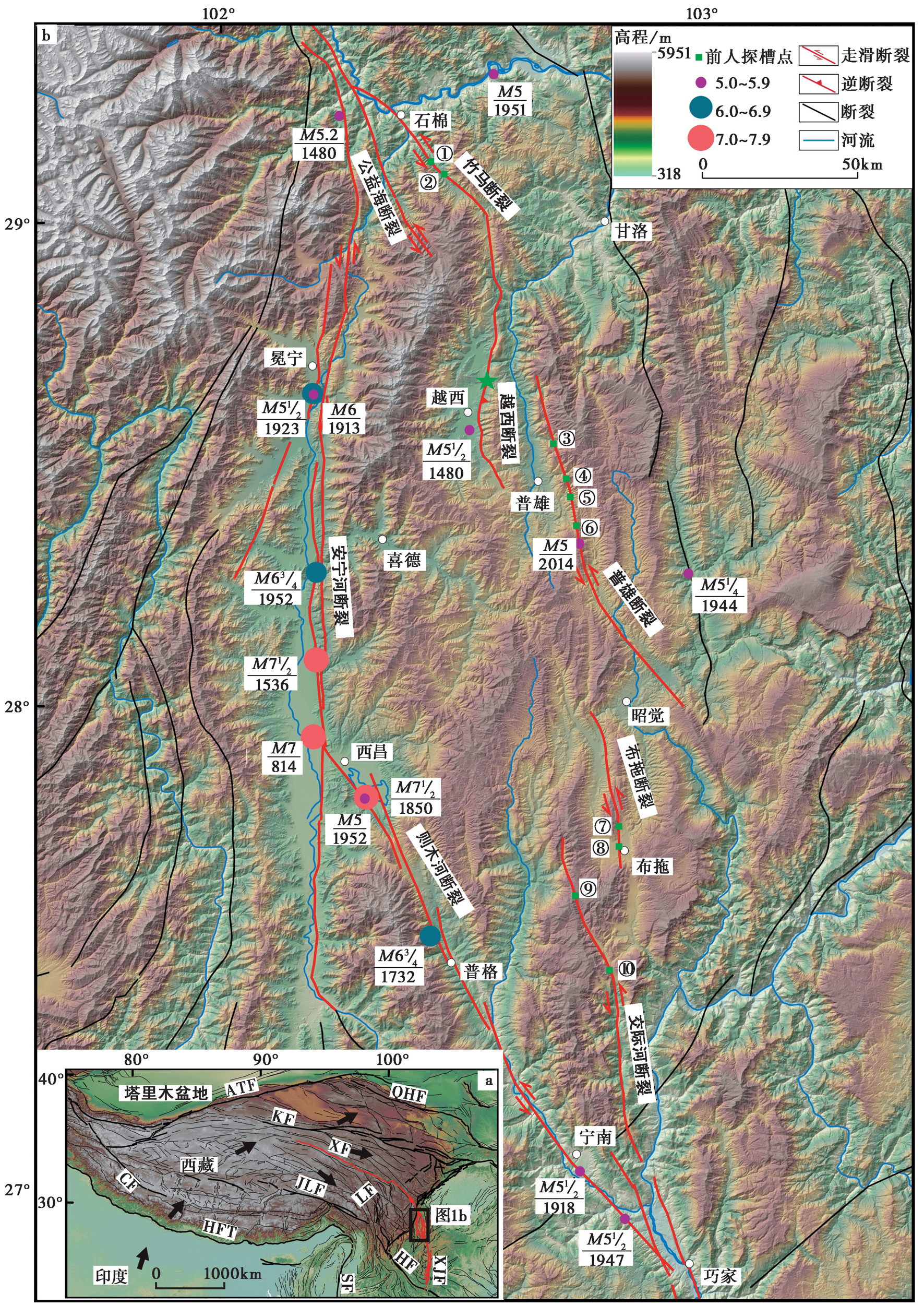
图1 大凉山断裂带分布图 a 青藏高原周缘主要活动断裂展布图, 红色粗线条代表鲜水河-小江断裂系, 黑色粗线为其他断裂; b 大凉山断裂带分布图, 地形底图源于SRTM3 DEM, 历史地震记录源于文献(国家地震局震害防御司, 1995; 中国地震局震害防御司, 1999), 现代地震记录源于中国地震台网中心。沿大凉山断裂带的古地震探槽点分别为: ①联合村探槽(冯嘉辉等, 2021); ②黑林子探槽(孙浩越等, 2015); ③曲古地探槽(周荣军等, 2003); ④三莫洛探槽(高伟等, 2016); ⑤克七拉打探槽(宋方敏等, 2002); ⑥洛莫探槽(高伟等, 2016); ⑦达子日探槽; ⑧洛色探槽; ⑨乌科探槽;⑩次子脚探槽(Sun et al., 2019)。绿色五角星为本研究的探槽点
Fig. 1 The distribution map of the Daliangshan fault zone.
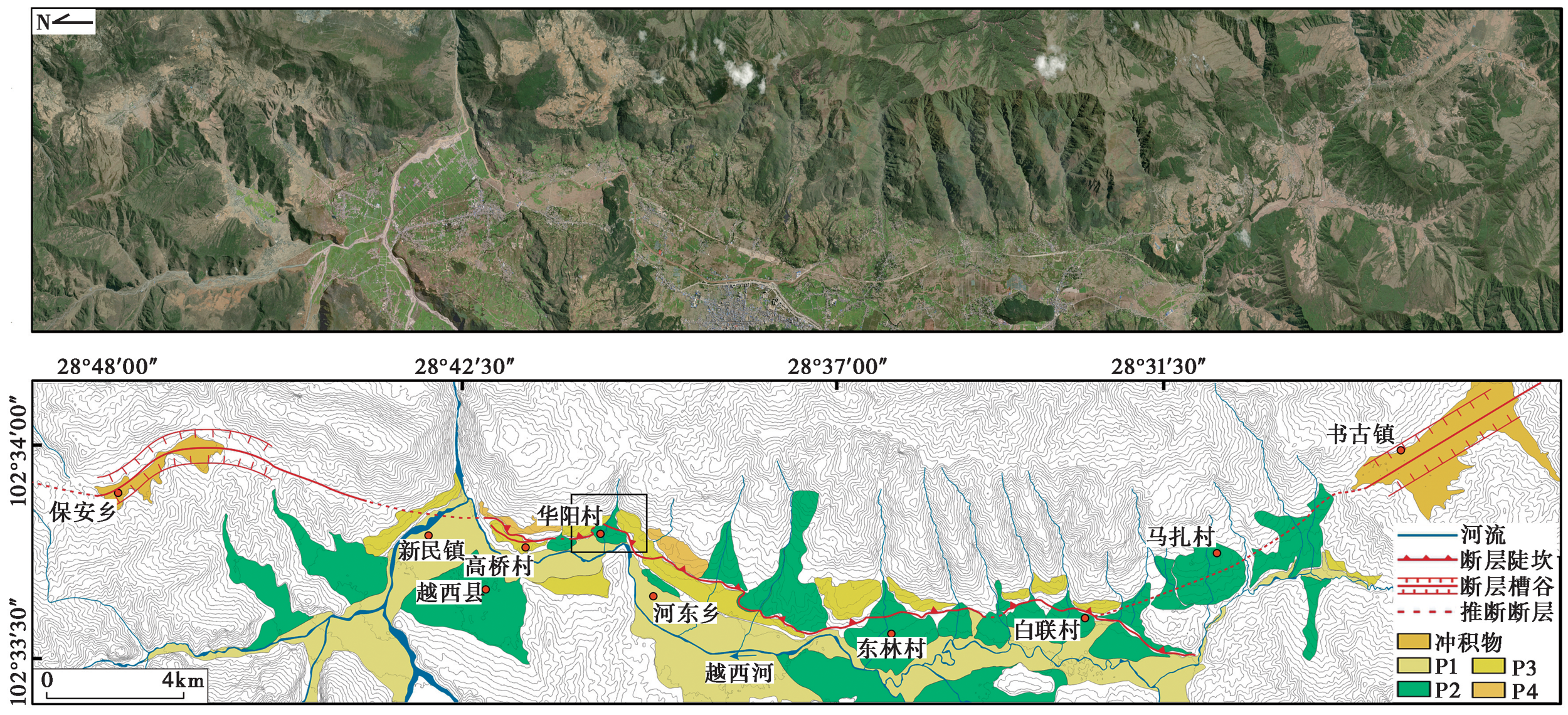
图2 越西断裂的展布图 底图源于WDMI影像, 图中黑色矩形框代表图3a的位置。P1-P4为洪积扇, 在时代上依次对应河流阶地T1-T4
Fig. 2 The spatial distribution of the Yuexi Fault.

图3 华阳村附近的断层地貌 a、b 华阳村附近的遥感影像及解译图, 底图源于WDMI影像, 黑色矩形框代表图c、d的位置。c 华阳村附近断错地貌的无人机航测高精度正射影像, 红色三角形表示断层活动迹线, 紫色矩形表示探槽位置; d 华阳村附近断错地貌的无人机航测高精度DEM解译图, 黑色带字母的线段表示跨断裂剖面线, 紫色矩形表示探槽位置; e 华阳村附近的断错地貌照片, 红色三角形表示断层的活动迹线, 紫色矩形表示探槽位置; f、g 冲沟一级阶地跨断裂的剖面图; h 冲沟二级阶地跨断裂的剖面图; i 二级洪积扇跨断裂的剖面图
Fig. 3 The faulted landforms near the Huayang village.

图4 华阳探槽北壁的拼接照片及解译图 a 黄色带字母的虚线矩形框为图6a-c的位置; b 黑线表示地层单元或子单元的界线, 红线表示断层, 红色小矩形表示样品的采集位置, U、C开头的黑色字母数字表示地层编号, DH开头的黑色字母数字表示样品编号, 黑色数字测年结果表示样品的测试年龄, 红字年代表示样品的OxCal校正年龄
Fig. 4 Photo mosaic(a) and interpretation log(b) of the north wall of the Huayang Trench.
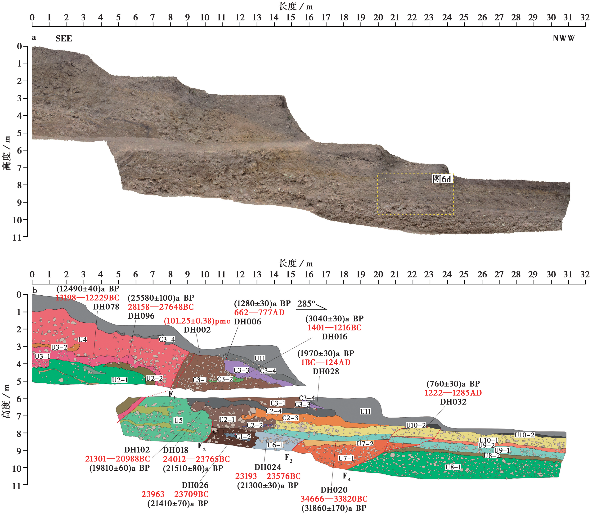
图5 华阳探槽南壁的拼接照片及解译图 a 黄色带字母的虚线矩形框表示图6d位置; b 黑线表示地层单元或子单元的界线, 红线表示断层, 红色小矩形表示样品的采集位置。U、C开头的黑色字母数字表示地层编号, DH开头的黑色字母数字表示样品编号, 黑色测年结果表示样品的测试年龄, 红字年代表示样品的OxCal校正年龄
Fig. 5 Photo mosaic(a) and interpretation log(b) of the south wall of the Huayang Trench.
| 地层单元 | 地层描述 |
|---|---|
| U1 | 槽洪相灰褐色含细砂砾石层。砾石直径2~10cm,次棱角状,分选差,层理不发育,其间夹有漫洪相黄褐色及灰褐色发育斜层理的细砂层。 |
| U2-1 | 槽洪相褐黄色夹紫红色含细砂砾石层。砾石直径多为2~4cm,次棱角状。在探槽北壁,顶部炭屑(DH063)的14C测年结果为(26 960±120)a BP。 |
| U2-2 | 黑色夹棕黄色淤泥层。含少量砾石,砾石直径1~3cm。在探槽南壁,顶部有机沉积物(DH096)的14C测年结果为(25 580±100)a BP。 |
| U3-1 | 漫洪相褐黄色含砾细砂层。砾石直径2~10cm。 |
| U3-2 | 漫洪相灰褐色粉砂层。顶部为褐黄色细砂层,发育斜层理。 |
| U4 | 槽洪相黄褐色含细砂砾石层。砾石直径2~10cm,次棱角状,发育斜层理。在探槽南壁,底部漫洪相夹层中炭粒(DH078)的14C测年结果为(12 490±40)a BP。 |
| U5 | 槽洪相灰褐色含细砂砾石层。砾石直径2~10cm,多为次棱角状,发育水平层理,其间夹有漫洪相黄褐色及灰褐色发育近水平层理的细砂层。在探槽南壁,下部漫洪相夹层中炭粒(DH102)的14C测年结果为(19 180±60)a BP;在探槽北壁,下部漫洪相夹层中炭屑(DH083)的14C测年结果为(22 890±90)a BP。 |
| C1-1 | 崩积楔,砾石与砂土混杂,无分选,无层理。 |
| C1-2 | 漫洪相灰褐色含黏土细砂层。含少量砾石,砾石直径2~4cm,多为次棱角状。在探槽南壁上部炭屑(DH026)的14C测年结果为(21 410±70)a BP;在探槽北壁,下部炭粒(DH029)的14C测年结果为(24 180±70)a BP。 |
| U6-1 | 槽洪相灰褐色含砂砾石层,砾石直径2~20cm,多为次棱角状。 |
| U6-2 | 漫洪相黄褐色细砂层。含少量砾石,砾石直径2~4cm,多为次棱角状,发育水平层理。在探槽北壁,下部炭屑(DH031)的14C测年结果为(25 110±120)a BP,与水平相变的C1-1地层单元的测年结果基本一致。 |
| U7-1 | 槽洪相黄褐色含细砂砾石层,砾石直径2~4cm,多为次棱角状,发育斜层理。 |
| U7-2 | 漫洪相灰褐色细砂层。含少量砾石,砾石直径2~4cm,多为次棱角状,发育水平层理。在探槽南壁,上部炭屑(DH020)的14C测年结果为(31 860±170)a BP。 |
| U8-1 | 槽洪相浅灰色夹紫红色含砂砾石层。砾石直径2~15cm,局部最大可达30cm,多为次棱角状,发育近水平层理。 |
| U8-2 | 漫洪相褐黑色夹深棕黄色淤泥层含少量砾石,砾石直径2~4cm,磨圆差。在探槽北壁,下部有机沉积物(DH045)的14C测年结果为(25 760±100)a BP。 |
| U9-1 | 槽洪相浅灰色含细砂砾石层。砾石直径2~6cm,多为次棱角状,发育水平层理,其间夹有漫洪相浅灰黄色发育水平层理的含砾细砂层。 |
| U9-2 | 漫洪相浅灰黄色含砾细砂层,砾石直径2~4cm,磨圆差,发育水平层理。 |
| C2-1 | 崩积楔,砾石与砂土混杂,无分选,无层理。 |
| C2-2 | 漫洪相灰褐色中砂层。含少量砾石,砾石直径1~2cm,发育近水平层理。在探槽南壁,炭屑(DH024)的14C测年结果为(21 300±70)a BP;在探槽北壁,炭屑(DH023)的14C测年结果为(20 990±80)a BP。 |
| C2-3 | 坡积相红褐色含砾细砂层,砾石直径2~4cm,次棱角状。 |
| C2-4 | 灰黑色古土壤层。含少量砾石,砾石直径2~4cm。在探槽南壁,靠近断层炭屑(DH018)的14C测年结果为(21 510±80)a BP;远离断层崩积楔坡脚上部有机沉积物(DH028)的14C测年结果为(1 970±30)a BP,其年龄明显偏年轻,层位靠近现代耕作层底部,受到后期污染;在探槽北壁,靠近断层炭屑(DH017)的14C测年结果为(19 080±80)a BP,远离断层的崩积楔坡脚上部有机沉积物(DH037)的14C测年结果为(2 020±30)a |
| C3-1 | 崩积楔,砾石与砂土混杂,无分选,无层理。 |
| C3-2 | 漫洪相灰褐色细砂层。含少量砾石,砾石直径2~4cm,发育近水平层理,近断层处发生拖曳变形。在探槽南壁,中部炭屑(DH016)的14C测年结果为(3 040±30)a BP;在探槽北壁,炭屑(DH013)的14C测年结果为(20 480±70)a BP。 |
| C3-3 | 坡积相红褐色细砂层,含少量砾石,砾石直径2~4cm,次棱角状。 |
| C3-4 | 灰黑色含砾古土壤。砾石直径4~8cm,局部最大可达25cm。在探槽南壁,下部有机沉积物(DH006)的14C测年结果为(1 280±30)a BP;在探槽北壁,下部有机沉积物(DH001)的14C测年结果为(1 340±30)a BP。 |
| U10-1 | 槽洪相棕黄色夹紫红色含细砂砾石层。砾石直径2~12cm,局部最大可达35cm,多为次棱角状,水平层理不发育。 |
| U10-2 | 灰黑色土壤化粉细砂层。顶部砾石近水平排列,砾石直径2~5cm,多为次棱角状。在探槽南壁下部获得的有机沉积物(DH032)的14C测年结果为(760±30)a BP;在探槽北壁下部获得的有机沉积物(DH041)的14C测年结果为(790±30)a BP。 |
| U11 | 现代耕作层。灰黑色含砾砂土层,结构松散,砾石直径2~9cm,磨圆差。 |
表 1 探槽揭露的地层序列
Table1 The strata units exposed by the trench
| 地层单元 | 地层描述 |
|---|---|
| U1 | 槽洪相灰褐色含细砂砾石层。砾石直径2~10cm,次棱角状,分选差,层理不发育,其间夹有漫洪相黄褐色及灰褐色发育斜层理的细砂层。 |
| U2-1 | 槽洪相褐黄色夹紫红色含细砂砾石层。砾石直径多为2~4cm,次棱角状。在探槽北壁,顶部炭屑(DH063)的14C测年结果为(26 960±120)a BP。 |
| U2-2 | 黑色夹棕黄色淤泥层。含少量砾石,砾石直径1~3cm。在探槽南壁,顶部有机沉积物(DH096)的14C测年结果为(25 580±100)a BP。 |
| U3-1 | 漫洪相褐黄色含砾细砂层。砾石直径2~10cm。 |
| U3-2 | 漫洪相灰褐色粉砂层。顶部为褐黄色细砂层,发育斜层理。 |
| U4 | 槽洪相黄褐色含细砂砾石层。砾石直径2~10cm,次棱角状,发育斜层理。在探槽南壁,底部漫洪相夹层中炭粒(DH078)的14C测年结果为(12 490±40)a BP。 |
| U5 | 槽洪相灰褐色含细砂砾石层。砾石直径2~10cm,多为次棱角状,发育水平层理,其间夹有漫洪相黄褐色及灰褐色发育近水平层理的细砂层。在探槽南壁,下部漫洪相夹层中炭粒(DH102)的14C测年结果为(19 180±60)a BP;在探槽北壁,下部漫洪相夹层中炭屑(DH083)的14C测年结果为(22 890±90)a BP。 |
| C1-1 | 崩积楔,砾石与砂土混杂,无分选,无层理。 |
| C1-2 | 漫洪相灰褐色含黏土细砂层。含少量砾石,砾石直径2~4cm,多为次棱角状。在探槽南壁上部炭屑(DH026)的14C测年结果为(21 410±70)a BP;在探槽北壁,下部炭粒(DH029)的14C测年结果为(24 180±70)a BP。 |
| U6-1 | 槽洪相灰褐色含砂砾石层,砾石直径2~20cm,多为次棱角状。 |
| U6-2 | 漫洪相黄褐色细砂层。含少量砾石,砾石直径2~4cm,多为次棱角状,发育水平层理。在探槽北壁,下部炭屑(DH031)的14C测年结果为(25 110±120)a BP,与水平相变的C1-1地层单元的测年结果基本一致。 |
| U7-1 | 槽洪相黄褐色含细砂砾石层,砾石直径2~4cm,多为次棱角状,发育斜层理。 |
| U7-2 | 漫洪相灰褐色细砂层。含少量砾石,砾石直径2~4cm,多为次棱角状,发育水平层理。在探槽南壁,上部炭屑(DH020)的14C测年结果为(31 860±170)a BP。 |
| U8-1 | 槽洪相浅灰色夹紫红色含砂砾石层。砾石直径2~15cm,局部最大可达30cm,多为次棱角状,发育近水平层理。 |
| U8-2 | 漫洪相褐黑色夹深棕黄色淤泥层含少量砾石,砾石直径2~4cm,磨圆差。在探槽北壁,下部有机沉积物(DH045)的14C测年结果为(25 760±100)a BP。 |
| U9-1 | 槽洪相浅灰色含细砂砾石层。砾石直径2~6cm,多为次棱角状,发育水平层理,其间夹有漫洪相浅灰黄色发育水平层理的含砾细砂层。 |
| U9-2 | 漫洪相浅灰黄色含砾细砂层,砾石直径2~4cm,磨圆差,发育水平层理。 |
| C2-1 | 崩积楔,砾石与砂土混杂,无分选,无层理。 |
| C2-2 | 漫洪相灰褐色中砂层。含少量砾石,砾石直径1~2cm,发育近水平层理。在探槽南壁,炭屑(DH024)的14C测年结果为(21 300±70)a BP;在探槽北壁,炭屑(DH023)的14C测年结果为(20 990±80)a BP。 |
| C2-3 | 坡积相红褐色含砾细砂层,砾石直径2~4cm,次棱角状。 |
| C2-4 | 灰黑色古土壤层。含少量砾石,砾石直径2~4cm。在探槽南壁,靠近断层炭屑(DH018)的14C测年结果为(21 510±80)a BP;远离断层崩积楔坡脚上部有机沉积物(DH028)的14C测年结果为(1 970±30)a BP,其年龄明显偏年轻,层位靠近现代耕作层底部,受到后期污染;在探槽北壁,靠近断层炭屑(DH017)的14C测年结果为(19 080±80)a BP,远离断层的崩积楔坡脚上部有机沉积物(DH037)的14C测年结果为(2 020±30)a |
| C3-1 | 崩积楔,砾石与砂土混杂,无分选,无层理。 |
| C3-2 | 漫洪相灰褐色细砂层。含少量砾石,砾石直径2~4cm,发育近水平层理,近断层处发生拖曳变形。在探槽南壁,中部炭屑(DH016)的14C测年结果为(3 040±30)a BP;在探槽北壁,炭屑(DH013)的14C测年结果为(20 480±70)a BP。 |
| C3-3 | 坡积相红褐色细砂层,含少量砾石,砾石直径2~4cm,次棱角状。 |
| C3-4 | 灰黑色含砾古土壤。砾石直径4~8cm,局部最大可达25cm。在探槽南壁,下部有机沉积物(DH006)的14C测年结果为(1 280±30)a BP;在探槽北壁,下部有机沉积物(DH001)的14C测年结果为(1 340±30)a BP。 |
| U10-1 | 槽洪相棕黄色夹紫红色含细砂砾石层。砾石直径2~12cm,局部最大可达35cm,多为次棱角状,水平层理不发育。 |
| U10-2 | 灰黑色土壤化粉细砂层。顶部砾石近水平排列,砾石直径2~5cm,多为次棱角状。在探槽南壁下部获得的有机沉积物(DH032)的14C测年结果为(760±30)a BP;在探槽北壁下部获得的有机沉积物(DH041)的14C测年结果为(790±30)a BP。 |
| U11 | 现代耕作层。灰黑色含砾砂土层,结构松散,砾石直径2~9cm,磨圆差。 |

图6 探槽剖面的断错细节图 a-c 探槽北壁的剖面细节图, 位置见图4a; b 探槽南壁的剖面细节图, 位置见图5a。U、C开头的黑色字母数字表示地层编号, DH开头的黑色字母数字表示样品编号, 红字年代表示样品的OxCal校正年龄
Fig. 6 The detail faults on the trench walls.
| 地层编号 | 样品编号 | 实验室编号 | 测试成分 | 初始年代 | 校正年代(2σ) |
|---|---|---|---|---|---|
| U2-1 | DH063 | 603442 | 炭屑 | (26960±120)a BP | 29234-29090BC(95.4%) |
| U2-2 | DH096 | 603432 | 有机沉积物 | (25580±100)a BP | 28158-27648BC(95.4%) |
| U4 | DH078 | 603433 | 炭粒 | (12490±40)a BP | 13198-12229BC(95.4%) |
| U5 | DH102 | 603431 | 炭粒 | (19810±60)a BP | 21301-20988BC(95.4%) |
| U5 | DH083 | 603443 | 炭屑 | (22890±90)a BP | 25492-25184BC(94.7%) |
| 25592-25563BC(0.7%) | |||||
| C1-2 | DH026 | 603434 | 炭屑 | (21410±70)a BP | 23963-23709BC(95.4%) |
| C1-2 | DH029 | 603435 | 炭粒 | (24180±90)a BP | 26724-26050BC(95.4%) |
| C2-2 | DH023 | 603436 | 炭屑 | (20990±80)a BP | 23668-23175BC(95.4%) |
| C2-2 | DH024 | 603424 | 炭屑 | (21300±70)a BP | 23193-23576BC(86.9%) |
| 23540-23393BC(8.6%) | |||||
| C2-4 | DH028 | 603426 | 有机沉积物 | (1970±30)a BP | 1BC-124AD(83.6%) |
| 41-9BC(11.9%) | |||||
| C2-4 | DH017 | 603437 | 炭屑 | (19080±60)a BP | 21662-20954BC(95.4%) |
| C2-4 | DH018 | 603425 | 炭屑 | (21510±80)a BP | 24012-23765BC(95.4%) |
| C2-4 | DH037 | 603438 | 有机沉积物 | (2020±30)a BP | 58BC-78AD(89.6%) |
| 98-70BC(5.4%) | |||||
| 102-106AD(0.4%) | |||||
| C3-2 | DH016 | 603427 | 炭屑 | (3040±30)a BP | 1401-1216BC(95.4%) |
| C3-2 | DH013 | 603439 | 炭屑 | (20480±70)a BP | 22981-22357BC(95.4%) |
| C3-4 | DH006 | 603428 | 有机沉积物 | (1280±30)a BP | 662-777AD(90.8%) |
| 791-821AD(47%) | |||||
| C3-4 | DH001 | 603440 | 有机沉积物 | (1340±30)a BP | 656-775AD(95.4%) |
| U6-2 | DH031 | 603444 | 炭屑 | (25110±120)a BP | 27874-27173BC(95.4%) |
| U7-2 | DH020 | 603423 | 炭屑 | (31860±170)a BP | 34666-33820BC(95.4%) |
| U8-2 | DH045 | 603445 | 有机沉积物 | (25760±100)a BP | 28264-27957BC(95.4%) |
| U10-2 | DH032 | 603429 | 有机沉积物 | (760±30)a BP | 1222-1285AD(95.4%) |
| U10-2 | DH041 | 603441 | 有机沉积物 | (790±30)a BP | 1215-1280AD(95.4%) |
| U11 | DH002 | 603430 | 有机沉积物 | (101.25±0.38)PMC |
表2 华阳探槽样品的放射性年龄及其年代校正
Table2 Radiocarbon ages and calibrated calendar dates of samples from the Huayang Trench
| 地层编号 | 样品编号 | 实验室编号 | 测试成分 | 初始年代 | 校正年代(2σ) |
|---|---|---|---|---|---|
| U2-1 | DH063 | 603442 | 炭屑 | (26960±120)a BP | 29234-29090BC(95.4%) |
| U2-2 | DH096 | 603432 | 有机沉积物 | (25580±100)a BP | 28158-27648BC(95.4%) |
| U4 | DH078 | 603433 | 炭粒 | (12490±40)a BP | 13198-12229BC(95.4%) |
| U5 | DH102 | 603431 | 炭粒 | (19810±60)a BP | 21301-20988BC(95.4%) |
| U5 | DH083 | 603443 | 炭屑 | (22890±90)a BP | 25492-25184BC(94.7%) |
| 25592-25563BC(0.7%) | |||||
| C1-2 | DH026 | 603434 | 炭屑 | (21410±70)a BP | 23963-23709BC(95.4%) |
| C1-2 | DH029 | 603435 | 炭粒 | (24180±90)a BP | 26724-26050BC(95.4%) |
| C2-2 | DH023 | 603436 | 炭屑 | (20990±80)a BP | 23668-23175BC(95.4%) |
| C2-2 | DH024 | 603424 | 炭屑 | (21300±70)a BP | 23193-23576BC(86.9%) |
| 23540-23393BC(8.6%) | |||||
| C2-4 | DH028 | 603426 | 有机沉积物 | (1970±30)a BP | 1BC-124AD(83.6%) |
| 41-9BC(11.9%) | |||||
| C2-4 | DH017 | 603437 | 炭屑 | (19080±60)a BP | 21662-20954BC(95.4%) |
| C2-4 | DH018 | 603425 | 炭屑 | (21510±80)a BP | 24012-23765BC(95.4%) |
| C2-4 | DH037 | 603438 | 有机沉积物 | (2020±30)a BP | 58BC-78AD(89.6%) |
| 98-70BC(5.4%) | |||||
| 102-106AD(0.4%) | |||||
| C3-2 | DH016 | 603427 | 炭屑 | (3040±30)a BP | 1401-1216BC(95.4%) |
| C3-2 | DH013 | 603439 | 炭屑 | (20480±70)a BP | 22981-22357BC(95.4%) |
| C3-4 | DH006 | 603428 | 有机沉积物 | (1280±30)a BP | 662-777AD(90.8%) |
| 791-821AD(47%) | |||||
| C3-4 | DH001 | 603440 | 有机沉积物 | (1340±30)a BP | 656-775AD(95.4%) |
| U6-2 | DH031 | 603444 | 炭屑 | (25110±120)a BP | 27874-27173BC(95.4%) |
| U7-2 | DH020 | 603423 | 炭屑 | (31860±170)a BP | 34666-33820BC(95.4%) |
| U8-2 | DH045 | 603445 | 有机沉积物 | (25760±100)a BP | 28264-27957BC(95.4%) |
| U10-2 | DH032 | 603429 | 有机沉积物 | (760±30)a BP | 1222-1285AD(95.4%) |
| U10-2 | DH041 | 603441 | 有机沉积物 | (790±30)a BP | 1215-1280AD(95.4%) |
| U11 | DH002 | 603430 | 有机沉积物 | (101.25±0.38)PMC |
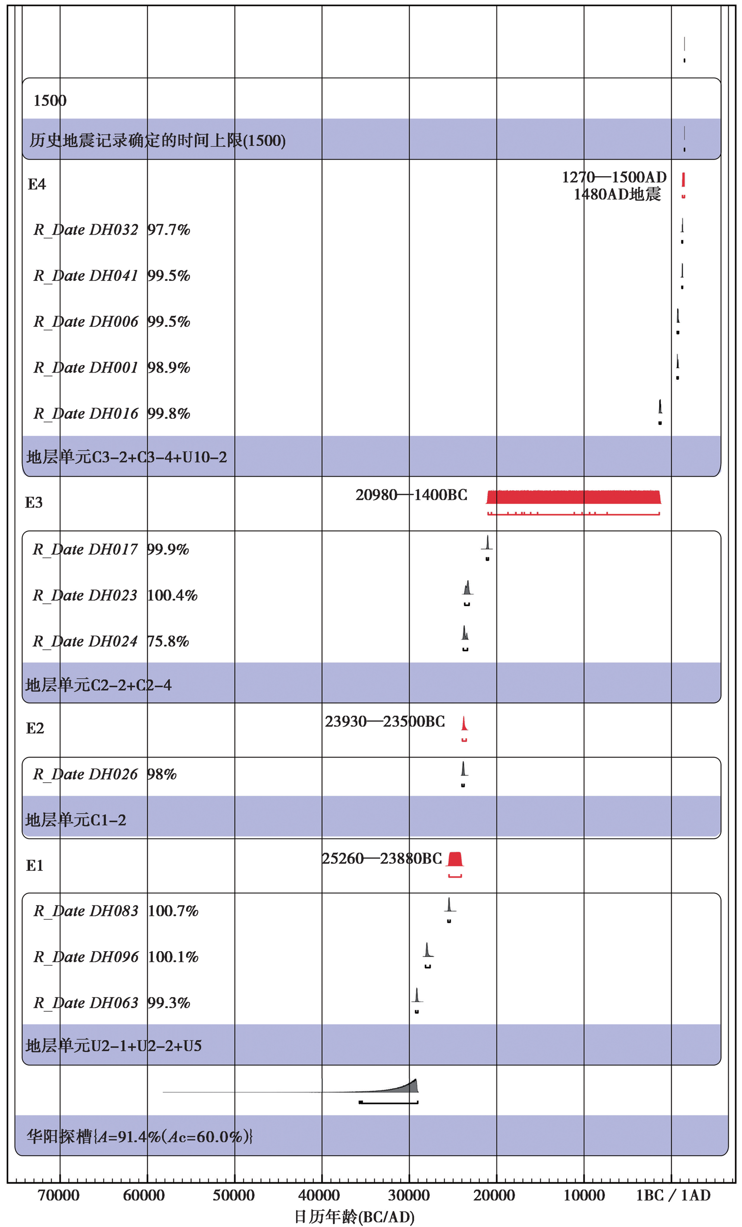
图7 事件年代的OxCal校正结果
Fig. 7 Results of OxCal analysis of radiocarbon dates from the trench.
| [1] | 陈长云. 2008. 越西盆地活动构造研究[D]. 北京: 中国地震局地质研究所. |
| CHEN Chang-yun. 2008. A study on active tectonics in Yuexi barin[D]. Beijing: Institute of Geology, CEA. (in Chinese) | |
| [2] | 陈桂华. 2006. 川滇块体北东边界活动构造带的构造转换与变形分界作用[D]. 北京: 中国地震局地质研究所. |
| CHEN Gui-hua. 2006. Structural transformation and strain partitioning along the northeast boundary belt of the Sichuan-Yunnan block[D]. Beijing: Institute of Geology, CEA. (in Chinese) | |
| [3] | 邓起东, 于贵华, 叶文华. 1992. 地震地表破裂参数与震级关系的研究 [A] ∥国家地震局地质研究所. 活动断裂研究(2). 北京: 地震出版社: 247-264. |
| DENG Qi-dong, YU Gui-hua, YE Wen-hua. 1992. Relationship between earthquake magnitude and parameters of surface ruptures associated with historical earthquakes [A]∥Institute of Geology, China Earthquake Administration. Research on Active Fault(The Second Edition). Seismological Press, Beijing: 247-264. (in Chinese) | |
| [4] | 邓起东, 张培震, 冉勇康, 等. 2002. 中国活动构造基本特征[J]. 中国科学(D辑), 32(12): 1020-1030. |
| DENG Qi-dong, ZHANG Pei-zhen, RAN Yong-kang, et al. 2002. Basic characteristics of active tectonics of China[J]. Science in China (Ser D), 32(12): 1020-1030. (in Chinese) | |
| [5] | 冯嘉辉, 陈立春, 王虎, 等. 2021. 大凉山断裂带北段石棉断裂的古地震[J]. 地震地质, 43(1): 53-71. |
| FENG JIA-hui, CHEN LI-chun, WANG Hu, et al. 2021. Paleoseismology study on the Shimian fault in the northern section of the Daliangshan fault zone[J]. Seismology and Geology, 43(1): 53-71. (in Chinese) | |
| [6] |
高伟, 何宏林, 孙浩越, 等. 2016. 大凉山断裂带中段普雄断裂晚第四纪古地震[J]. 地震地质, 38(4): 797-816. doi: 10.3969/j.issn.0253-4967.2016.04.001.
DOI |
| GAO Wei, HE Hong-lin, SUN Hao-yue, et al. 2016. Paleoearthquakes along the Puxiong Fault of the Daliangshan fault zone during late Quaternary[J]. Seismology and Geology, 38(4): 797-816. (in Chinese) | |
| [7] | 国家地震局震害防御司. 1995. 中国历史强震目录(公元前23世纪-公元1911年)[Z]. 北京: 地震出版社. |
| Department of Earthquake Disaster Prevention, State Seismological Bureau. 1995. Catalog of Historical Strong Earthquakes in China(23rd Century BC to 1911AD)[Z]. Seismological Press, Beijing. (in Chinese) | |
| [8] | 何宏林, 池田安隆. 2007. 安宁河断裂带晚第四纪运动特征及模式的讨论[J]. 地震学报, 29(5): 537-548. |
| HE Hong-lin, Ikeda Y. 2007. Faulting on the Anninghe fault zone, southwest China in late Quaternary and its movement model[J]. Acta Seismologica Sinica, 29(5): 537-548. (in Chinese) | |
| [9] | 何宏林, 池田安隆, 何玉林, 等. 2008. 新生的大凉山断裂带: 鲜水河-小江断裂系中段的裁弯取直[J]. 中国科学(D辑), 38(5): 564-574. |
| HE Hong-lin, Ikeda Y, HE Yu-lin, et al. 2008. Newly-generated Daliangshan fault zone: Shortcutting on the central section of Xianshuihe-Xiaojiang fault system[J]. Science in China(Ser D), 38(5): 564-574. | |
| [10] | 黄玮琼, 李文香, 曹学锋. 1994. 中国大陆地震资料完整性研究之二[J]. 地震学报, 16(4): 423-432. |
| HUANG Wei-qiong, LI Wen-xiang, CAO Xue-feng. 1994. Completeness analysis for earthquake catalogs in China mainland Ⅱ[J]. Acta Seismologica Sinica, 16(4): 423-432. (in Chinese) | |
| [11] | 李林蔚. 2015. 四川越西、甘洛等五县市方言音系研究[D]. 成都: 四川师范大学. |
| LI Lin-wei. 2015. The study of dialect phonetic system in five counties and cities of Sichuan[D]. Sichuan Normal University, Chengdu. (in Chinese) | |
| [12] | 李玶. 1993. 鲜水河-小江断裂带[M]. 北京: 地震出版社. |
| LI Ping. 1993. The Xianshuihe-Xiaojiang Fault Zone[M]. Seismological Press, Beijing. (in Chinese) | |
| [13] | 冉勇康, 程建武, 宫会玲, 等. 2008. 安宁河断裂紫马跨一带晚第四纪地貌变形与断层位移速率[J]. 地震地质, 30(1): 86-98. |
| RAN Yong-kang, CHENG Jian-wu, GONG Hui-ling, et al. 2008. Late quaternary geomorphic deformation and displacement rates of the Anninghe fault around zimakua[J]. Seismology and Geology, 30(1): 86-98. (in Chinese) | |
| [14] |
冉勇康, 陈立春, 陈文山, 等. 2012. 中国大陆古地震研究的关键技术与案例解析(2): 汶川地震地表变形特征与褶皱逆断层古地震识别[J]. 地震地质, 34(3): 385-400. doi: 10.3969/j.issn.0253-4967.2012.03.001.
DOI |
| RAN Yong-kang, CHEN Li-chun, CHEN Wen-shan, et al. 2012. Key techniques and several cases analysis in paleoseismic studies in mainland China(2): surface deformation characteristics of Wenchuan earthquake and paleoseismic indicators on fold-reverse fault[J]. Seismology and Geology, 34(3): 385-400. (in Chinese) | |
| [15] | 邵延秀. 2018. 走滑断裂阶区度地震复发行为研究--以阿尔金-海原走滑断裂西为例[D]. 北京: 中国地震局地质研究所. |
| SHAO Yan-xiu. 2019. Paleoseismological study of step-over on the Altyn Tagh-Haiyuan fault system[D]. Beijing: Institute of Geology, CEA. (in Chinese) | |
| [16] | 宋方敏, 李如成, 徐锡伟. 2002. 四川大凉山断裂带古地震研究初步结果[J]. 地震地质, 24(1): 27-34. |
| SONG Fang-min, LI Ru-cheng, XU Xi-wei. 2002. Preliminary results of the investigation of paleo-earthquakes along the Daliangshan fault zone, Sichuan Province, China[J]. Seismology and Geology, 24(1): 27-34. (in Chinese) | |
| [17] | 孙成民. 2010. 四川地震全记录(公元前26年-公元1949年9月)[M]. 成都: 四川人民出版社: 13-15. |
| SUN Cheng-min. 2010. Complete Record of Earthquakes in Sichuan (from 26BC to Sept. 1949AD)[M]. Sichuan People’s Publishing House, Chengdu: 13-15. (in Chinese) | |
| [18] |
孙浩越, 何宏林, 魏占玉, 等. 2015. 大凉山断裂带北段东支--竹马断裂晚第四纪活动性[J]. 地震地质, 37(2): 440-454. doi: 10.3969/j.issn.0253-4967.2015.02.008.
DOI |
| SUN Hao-yue, HE Hong-lin, WEI Zhan-yu, et al. 2015. The late Quaternary activity of Zhuma Fault on the north segment of Daliangshan fault zone[J]. Seismology and Geology: 37( 2): 440-454. (in Chinese) | |
| [19] |
王虎, 冉勇康, 陈立春, 等. 2018. 安宁河断裂带南段滑动速率估计[J]. 地震地质, 40(5): 967-979. doi: 10.3969/j.issn.0253-4967.2018.05.002.
DOI |
| WANG Hu, RAN Yong-kang, CHEN Li-chun, et al. 2018. Determination of slip rate on the southern segment of the Anninghe fault[J]. Seismology and Geology, 40(5): 967-979. (in Chinese) | |
| [20] |
魏占玉, 何宏林, 石峰, 等. 2012. 大凉山断裂带南段滑动速率估计[J]. 地震地质, 34(2): 282-293. doi: 10.3969/j.issn.0253-4967.2012.02.007.
DOI |
| WEI Zhan-yu, HE Hong-lin, SHI Feng, et al. 2012. Slip rate on the south segment of Daliangshan fault zone[J]. Seismology and Geology, 34(2): 282-293. (in Chinese) | |
| [21] | 徐锡伟, 闻学泽, 郑荣章, 等. 2003. 川滇地区活动块体最新构造变动样式及其动力来源[J]. 中国科学(D辑), 33(S1): 151-162. |
| XU Xi-wei, WEN Xue-ze, ZHENG Rong-zhang, et al. 2003. Newly tectonic deformation and its dynamic source of the Sichuan-Yunnan block[J]. Science in China(Ser D), 33(S1): 151-162. (in Chinese) | |
| [22] | 越西县志编纂委员会. 1994. 越西县志[M]. 成都: 四川辞书出版社. |
| Yuexi County Annals Compilation Committee. 1994. Annals of Yuexi County[M]. Sichuan Lexicographical Publishing House Co. Ltd, Chengdu. (in Chinese) | |
| [23] | 张培震, 邓起东, 张国民, 等. 2003. 中国大陆的强震活动与活动地块[J]. 中国科学(D辑), 33(S1): 12-20. |
| ZHANG Pei-zhen, DENG Qi-dong, ZHANG Guo-min, et al. 2003. Active tectonic blocks and strong earthquakes in continental China[J]. Science in China(Ser D), 33(S1): 12-20. (in Chinese) | |
| [24] | 中国地震局震害防御司编. 1999. 中国近代地震目录(公元1912-1990年, MS≥4.7)[Z]. 北京: 中国科学技术出版社: 227-228. |
| Department of Earthquake Disaster Prevention, China Earthquake Administration. 1999. Catalogue of Chinese Earthquakes(1912-1990, MS≥4.7)[Z]. China Science and Technology Press, Beijing: 227-228. (in Chinese) | |
| [25] | 周荣军, 黎小刚, 黄祖智, 等. 2003. 四川大凉山断裂带的晚第四纪平均滑动速率[J]. 地震研究, 26(2): 191-196. |
| ZHOU Rong-jun, LI Xiao-gang, HUANG Zu-zhi, et al. 2003. Average slip rate of Daliang Mountains fault zone in Sichuan in late Quaternary period[J]. Journal of Seismological Research, 26(2): 191-196. (in Chinese) | |
| [26] |
Bronk-Ramsey C. 1998. Radiocarbon calibration and analysis of stratigraphy: The OxCal program[J]. Radiocarbon, 37(2): 425-430.
DOI URL |
| [27] |
He H L, Ikeday Y, He Y L, et al. 2008. Newly-generated Daliangshan fault zone: Shortcutting on the central section of Xianshuihe-Xiaojiang fault system[J]. Science in China(Ser D), 51(9): 1248-1258.
DOI URL |
| [28] |
Sun H Y, He H L, Ikeday Y, et al. 2019. Paleoearthquake history along the southern segment of the Daliangshan fault zone in the southeastern Tibetan plateau[J]. Tectonics, 38(7): 2208-2231.
DOI URL |
| [29] | Wells D L, Coppersmith K J. 1994. New empirical relationships among magnitude, rupture length, rupture wide, rupture area, and surface displacement[J]. Bulletin of the Seismological Society of America, 84(4): 974-1002. |
| [30] |
Wen X Z, Ma S L, Xu X W, et al. 2008. Historical pattern and behavior of earthquake ruptures along the eastern boundary of the Sichuan-Yunnan faulted-block, southwestern China[J]. Physics of the Earth and Planetary Interiors, 168(1): 16-36.
DOI URL |
| [1] | 左玉琦, 杨海波, 杨晓平, 詹艳, 李安, 孙翔宇, 胡宗凯. 阿拉善地块南缘北大山断裂的晚第四纪构造活动证据[J]. 地震地质, 2023, 45(2): 355-376. |
| [2] | 李安, 万波, 王晓先, 计昊旻, 索锐. 金州断裂盖州北鞍山段古地震破裂的新证据[J]. 地震地质, 2023, 45(1): 111-126. |
| [3] | 郑海刚, 姚大全, 赵朋, 杨源源, 黄金水. 郯庐断裂带赤山段全新世新活动的特征[J]. 地震地质, 2023, 45(1): 127-138. |
| [4] | 原浩东, 李安, 黄伟亮, 胡宗凯, 左玉琦, 杨晓平. 西准噶尔地区托里断裂晚第四纪构造变形[J]. 地震地质, 2023, 45(1): 49-66. |
| [5] | 张伟恒, 陈杰, 李涛, 邸宁, 姚远. 龙门山前陆冲断带南段三苏场背斜晚第四纪变形速率[J]. 地震地质, 2022, 44(6): 1351-1364. |
| [6] | 杨源源, 李鹏飞, 路硕, 疏鹏, 潘浩波, 方良好, 郑海刚, 赵朋, 郑颖平, 姚大全. 郯庐断裂带中段F5断裂淮河-女山湖段的古地震与垂直滑动速率[J]. 地震地质, 2022, 44(6): 1365-1383. |
| [7] | 石文芳, 徐伟, 尹金辉, 郑勇刚. 秦岭北缘古地震基岩崩塌和滑坡施密特锤暴露年龄[J]. 地震地质, 2022, 44(6): 1384-1402. |
| [8] | 冯晶晶, 赵勇伟, 李霓, 陈正全, 王丽竹, 刘永顺, 聂保锋, 张学斌. 琼北晚第四纪火山锥体形貌与喷发机制[J]. 地震地质, 2022, 44(5): 1107-1127. |
| [9] | 沈军, 戴训也, 肖淳, 焦轩凯, 白其乐格尔, 邓梅, 刘泽众, 夏方华, 刘玉, 刘明. 夏垫西断裂的晚第四纪活动性[J]. 地震地质, 2022, 44(4): 909-924. |
| [10] | 徐伟, 刘志成, 王继, 高战武, 尹金辉. 西藏阿里地区喀喇昆仑断裂断错地貌及最近强震活动时代的初步研究[J]. 地震地质, 2022, 44(4): 925-943. |
| [11] | 张驰, 李智敏, 任治坤, 刘金瑞, 张志亮, 武登云. 日月山断裂南段晚第四纪活动特征[J]. 地震地质, 2022, 44(1): 1-19. |
| [12] | 刘兴旺, 袁道阳, 姚赟胜, 邹小波. 三危山断裂敦煌段古地震活动特征[J]. 地震地质, 2021, 43(6): 1398-1411. |
| [13] | 常昊, 常祖峰, 刘昌伟. 金沙江断裂带活动与大型滑坡群的关系研究:以金沙江拿荣—绒学段为例[J]. 地震地质, 2021, 43(6): 1435-1458. |
| [14] | 常祖峰, 常昊, 李鉴林, 毛泽斌, 臧阳. 维西-乔后断裂全新世活动与古地震[J]. 地震地质, 2021, 43(4): 881-898. |
| [15] | 杨晨艺, 李晓妮, 冯希杰, 朱琳, 李苗, 张恩会. 渭河盆地北缘口镇-关山断层的晚第四纪—现今的活动性[J]. 地震地质, 2021, 43(3): 504-520. |
| 阅读次数 | ||||||
|
全文 |
|
|||||
|
摘要 |
|
|||||
