地震地质 ›› 2022, Vol. 44 ›› Issue (5): 1313-1332.DOI: 10.3969/j.issn.0253-4967.2022.05.014
张博譞1),2),3),6)( ), 郑文俊1),2),3),*(), 陈杰3),4), 何骁慧1),2), 李启雷5), 张冬丽1),2),3), 段磊1,2,3), 陈干1),2),3)
收稿日期:2021-07-16
修回日期:2022-02-27
出版日期:2022-10-20
发布日期:2022-11-28
通讯作者:
郑文俊
作者简介:张博譞, 男, 1992年生, 2022年于中山大学获构造地质学博士学位, 主要研究方向为新构造与活动构造, E-mail: zhangboxuan92@163.com。
基金资助:
ZHANG Bo-xuan1),2),3),6)(), ZHENG Wen-jun1),2),3)(), CHEN Jie3),4), HE Xiao-hui1),2), LI Qi-lei5), ZHANG Dong-li1),2),3), DUAN Lei1,2,3), CHEN Gan1),2),3)
Received:2021-07-16
Revised:2022-02-27
Online:2022-10-20
Published:2022-11-28
Contact:
ZHENG Wen-jun
摘要:
青海茫崖 MS5.8 地震发生在祁连山与柴达木盆地交界的部位。对于此次地震开展研究, 不仅有助于理解柴达木盆地与祁连山之间的现今构造变形、 应力状态及动力学过程, 也将为该区未来的强震趋势预测提供依据。文中首先利用CAP方法反演得到该次地震的震源深度约为13km, 震源机制解为逆冲性质。结合地表地质、 卫星影像和地震反射剖面解译, 认为该地震发生在冷湖逆断裂-褶皱带的东南端, 发震构造可能为冷湖七号东背斜之下控制背斜生长的2条倾向相反的隐伏逆冲断裂之一。此次茫崖5.8级地震仅使冷湖七号东背斜下伏逆断层发生了部分破裂, 并未破裂至地表, 为典型的褶皱地震。震区发育多条第四纪活动褶皱及下伏逆断层, 这些构造均具备发生 MW5.9 ~7.2地震的构造条件, 并有可能因级联地震破裂而引发7级以上强震。因此, 震区未来的地震危险性不容忽视。
张博譞, 郑文俊, 陈杰, 何骁慧, 李启雷, 张冬丽, 段磊, 陈干. 柴达木盆地北部2021年6月16日青海茫崖MS5.8地震发震构造分析[J]. 地震地质, 2022, 44(5): 1313-1332.
ZHANG Bo-xuan, ZHENG Wen-jun, CHEN Jie, HE Xiao-hui, LI Qi-lei, ZHANG Dong-li, DUAN Lei, CHEN Gan. ANALYSIS OF THE SEISMOGENIC STRUCTURE OF THE JUNE 2021 MS5.8 MANG’AI EARTHQUAKE IN NORTHERN QAIDAM BASIN[J]. SEISMOLOGY AND GEOLOGY, 2022, 44(5): 1313-1332.
| 来源 | 震中位置 | 震源 深度 /km | 震级 | 节面Ⅰ | 节面Ⅱ | P轴 | T轴 | B轴 | ||||||||
|---|---|---|---|---|---|---|---|---|---|---|---|---|---|---|---|---|
| 北纬/(°) | 东经/(°) | 走向/(°) | 倾角/(°) | 滑动角/(°) | 走向/(°) | 倾角/(°) | 滑动角/(°) | 方位 /(°) | 倾角/(°) | 方位 /(°) | 倾角/(°) | 方位 /(°) | 倾角/(°) | |||
| CENC | 38.14 | 93.81 | 10 | MS5.8 | ||||||||||||
| USGS | 38.21 | 93.72 | 14 | MW5.4 | 298 | 45 | 106 | 97 | 47 | 75 | 197 | 1 | 291 | 79 | 107 | 11 |
| GCMT | 38.25 | 93.72 | 17 | MW5.5 | 279 | 49 | 86 | 106 | 41 | 95 | 12 | 4 | 154 | 85 | 282 | 3 |
| GFZ | 38.13 | 93.76 | 17 | MS5.5 | 289 | 43 | 102 | 93 | 47 | 78 | ||||||
| 本文 | 38.14 | 93.81 | 13 | MW5.3 | 291 | 41 | 91 | 110 | 49 | 89 | 200 | 4 | 11 | 86 | 110 | 1 |
表1 不同机构给出的茫崖 MS5.8 地震的参数
Table1 The results of focal mechanisms of the Mang’ai MS5.8 earthquake
| 来源 | 震中位置 | 震源 深度 /km | 震级 | 节面Ⅰ | 节面Ⅱ | P轴 | T轴 | B轴 | ||||||||
|---|---|---|---|---|---|---|---|---|---|---|---|---|---|---|---|---|
| 北纬/(°) | 东经/(°) | 走向/(°) | 倾角/(°) | 滑动角/(°) | 走向/(°) | 倾角/(°) | 滑动角/(°) | 方位 /(°) | 倾角/(°) | 方位 /(°) | 倾角/(°) | 方位 /(°) | 倾角/(°) | |||
| CENC | 38.14 | 93.81 | 10 | MS5.8 | ||||||||||||
| USGS | 38.21 | 93.72 | 14 | MW5.4 | 298 | 45 | 106 | 97 | 47 | 75 | 197 | 1 | 291 | 79 | 107 | 11 |
| GCMT | 38.25 | 93.72 | 17 | MW5.5 | 279 | 49 | 86 | 106 | 41 | 95 | 12 | 4 | 154 | 85 | 282 | 3 |
| GFZ | 38.13 | 93.76 | 17 | MS5.5 | 289 | 43 | 102 | 93 | 47 | 78 | ||||||
| 本文 | 38.14 | 93.81 | 13 | MW5.3 | 291 | 41 | 91 | 110 | 49 | 89 | 200 | 4 | 11 | 86 | 110 | 1 |
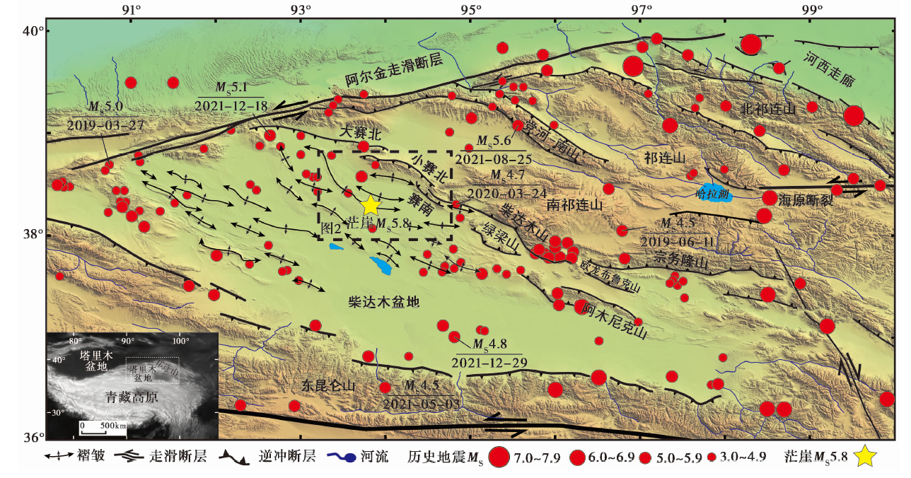
图1 柴达木盆地及邻区主要构造简图与2021年6月16日青海省海西蒙古族藏族自治州茫崖5.8级地震的震中位置 据文献(Yin et al., 2008)修改, 地震目录引自全球矩心矩张量(GCMT)目录网站①(① https://www.globalcmt.org。)
Fig. 1 The location of the epicenter of the MS5.8 Mang’ai earthquake in Haixi Prefecture, Qinghai Province, June 16, 2021.
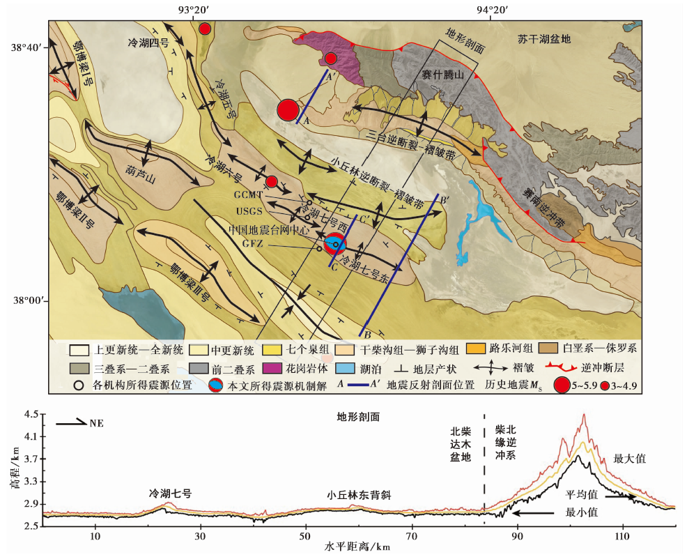
图2 震区地质图及条带地形剖面 据Google Earth卫星影像图及1︰20地质图解译; 空心圆为不同机构给出的 MS5.8 地震的震中位置; 震源机制解采用本文所得结果
Fig. 2 Geological map of the study area based on Google Earth image interpretation and swath topographic profile.

图3 a 茫崖 MS5.8 地震震中与地震监测台站分布图; b 茫崖 MS5.8 地震震源机制反演误差随震源深度的变化图(初始深度设定为10km)
Fig. 3 The epicenter of Mang’ai MS5.8 earthquake and distribution of seismic monitoring stations(a); The variation of misfit error with focal depth during the focal mechanism inversion of the Mang’ai MS5.8 earthquake(b) (The initial depth is set to 10km).
| 厚度/km | P波速度/km·s-1 | S波速度/km·s-1 |
|---|---|---|
| 0.5 | 2.50 | 1.20 |
| 0.5 | 4.00 | 2.10 |
| 18.0 | 6.00 | 3.50 |
| 18.0 | 6.40 | 3.70 |
| 18.0 | 7.10 | 3.90 |
| 0.0 | 8.15 | 4.70 |
表2 速度模型
Table2 The velocity models
| 厚度/km | P波速度/km·s-1 | S波速度/km·s-1 |
|---|---|---|
| 0.5 | 2.50 | 1.20 |
| 0.5 | 4.00 | 2.10 |
| 18.0 | 6.00 | 3.50 |
| 18.0 | 6.40 | 3.70 |
| 18.0 | 7.10 | 3.90 |
| 0.0 | 8.15 | 4.70 |
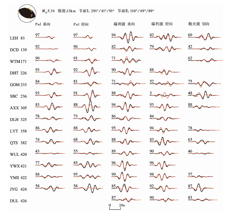
图4 茫崖 MS5.8 地震的理论地震图与观测波形拟合图 红色实线为理论地震图, 黑色实线为观测波形图, 台站名右侧数字为震中距(单位: km), 波形上方的数字分别代表理论地震图与观测地震图的互相关系数(百分比)
Fig. 4 The focal mechanism solution and comparison between observed and synthetic waveforms of the Mang’ai MS5.8 earthquake.
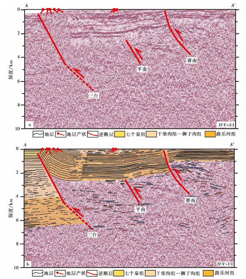
图5 三台背斜带构造的典型地震反射剖面 a 原始剖面(剖面位置见图2a中的AA'); b 解译剖面(据Cheng et al., 2019修改)
Fig. 5 Seismic section across the Santai anticline.
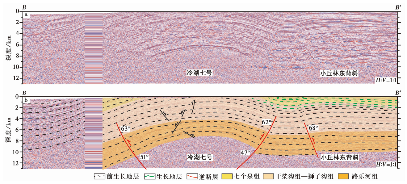
图6 冷湖七号东背斜的典型地震反射剖面(据余梦丽, 2018; Luo et al., 2022修改) a 原始剖面(剖面位置见图2a中的BB'); b 解译剖面
Fig. 6 Seismic section across the Lenghu No. 7 anticline(modified from YU Meng-li, 2018; Luo et al., 2022).
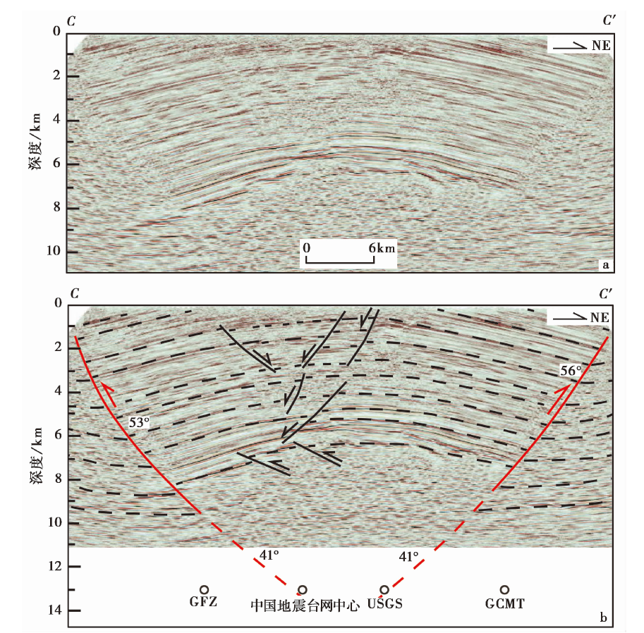
图7 冷湖七号东背斜的典型地震反射剖面(据李宏义等, 2007; Luo et al., 2022修改) a 原始剖面(剖面位置见图2a中的CC'); b 解译剖面。空心圆为不同机构给出的震中位置的投影
Fig. 7 Seismic section across the Lenghu No. 7 anticline(modified from LI Hong-yi et al., 2007; Luo et al., 2022).

图8 鄂博梁Ⅱ号背斜的典型地震剖面(据Luo et al., 2022) a 原始剖面; b 解释剖面
Fig. 8 Typical seismic profile across the Eboliang No.2 anticline(after Luo et al., 2022).
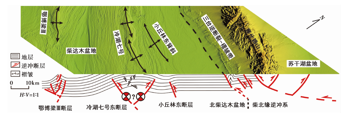
图9 青海茫崖5.8级地震的发震构造模型
Fig. 9 Seismogenic model of MS5.8 Mang’ai earthquake in Qinghai Province.
| 构造带名称 | 地表背斜 | 地表 背斜长度 /km | 上断点 埋深 /km | Leonard, (MW)* | Wells等, (MW)* | Leonard, (MW)# | Wells等, 1994 (MW)# |
|---|---|---|---|---|---|---|---|
| 三台逆断裂-褶皱带 | 级联全部破裂 | 61 | 0~1 | 7.0 | 6.8 | 7.2 | 7.0 |
| 小丘林逆断裂- 褶皱带 | 小丘林西、 东背斜 | 33~44 | 4~6 | 6.2~6.6 | 6.1~6.4 | 6.8~7.0 | 6.6~6.8 |
| 级联全部破裂 | 77 | 4~6 | 6.7 | 6.6 | 7.2 | 7.0 | |
| 冷湖逆断裂- 褶皱带 | 西段冷湖带 | 7~12 | 0~1 | 6.0~6.3 | 5.9~6.2 | 6.3~6.5 | 6.2~6.4 |
| 中段冷湖带 | 7~31 | 3~6 | 5.9~6.3 | 5.9~6.2 | 6.2~6.8 | 6.1~6.6 | |
| 东段冷湖带 | 32~48 | 2~3 | 6.2~6.5 | 6.1~6.4 | 6.6~6.9 | 6.5~6.7 | |
| 冷湖七号西段 | 17 | 3 | 6.3 | 6.2 | 6.6 | 6.5 | |
| 冷湖七号东段 | 25 | 6 | 6.2 | 6.1 | 6.7 | 6.6 | |
| 级联全部破裂 | 144 | 0~6 | 7.1 | 7.0 | 7.5 | 7.3 | |
| 鄂博梁逆断裂- 褶皱带 | 鄂博梁Ⅰ-Ⅲ号 | 40~50 | 4~7 | 6.4~6.6 | 6.3~6.5 | 7.0 | 6.8 |
| 葫芦山 | 38 | 5 | 6.5 | 6.4 | 6.9 | 6.8 | |
| 级联全部破裂 | 175 | 4~7 | 7.1 | 7.0 | 7.6 | 7.3 |
表3 震区主要活动构造的破裂面积及其最大潜在地震的矩震级
Table3 Multi-spatial rupture area and maximum potential seismic moment magnitude of the main faults
| 构造带名称 | 地表背斜 | 地表 背斜长度 /km | 上断点 埋深 /km | Leonard, (MW)* | Wells等, (MW)* | Leonard, (MW)# | Wells等, 1994 (MW)# |
|---|---|---|---|---|---|---|---|
| 三台逆断裂-褶皱带 | 级联全部破裂 | 61 | 0~1 | 7.0 | 6.8 | 7.2 | 7.0 |
| 小丘林逆断裂- 褶皱带 | 小丘林西、 东背斜 | 33~44 | 4~6 | 6.2~6.6 | 6.1~6.4 | 6.8~7.0 | 6.6~6.8 |
| 级联全部破裂 | 77 | 4~6 | 6.7 | 6.6 | 7.2 | 7.0 | |
| 冷湖逆断裂- 褶皱带 | 西段冷湖带 | 7~12 | 0~1 | 6.0~6.3 | 5.9~6.2 | 6.3~6.5 | 6.2~6.4 |
| 中段冷湖带 | 7~31 | 3~6 | 5.9~6.3 | 5.9~6.2 | 6.2~6.8 | 6.1~6.6 | |
| 东段冷湖带 | 32~48 | 2~3 | 6.2~6.5 | 6.1~6.4 | 6.6~6.9 | 6.5~6.7 | |
| 冷湖七号西段 | 17 | 3 | 6.3 | 6.2 | 6.6 | 6.5 | |
| 冷湖七号东段 | 25 | 6 | 6.2 | 6.1 | 6.7 | 6.6 | |
| 级联全部破裂 | 144 | 0~6 | 7.1 | 7.0 | 7.5 | 7.3 | |
| 鄂博梁逆断裂- 褶皱带 | 鄂博梁Ⅰ-Ⅲ号 | 40~50 | 4~7 | 6.4~6.6 | 6.3~6.5 | 7.0 | 6.8 |
| 葫芦山 | 38 | 5 | 6.5 | 6.4 | 6.9 | 6.8 | |
| 级联全部破裂 | 175 | 4~7 | 7.1 | 7.0 | 7.6 | 7.3 |
| [1] |
白亚东, 杨巍, 马峰, 等. 2019. 柴北缘冷湖七号-南八仙地区构造特征及油气勘探方向[J]. 特种油气藏, 26(1): 75-79. doi: 10.3969/j.issn.1006-6535.2019.01.013.
DOI |
|
|
|
| [2] |
陈俊厢, 陈景亮. 2003. 若羌-阿勒泰区域剖面的速度特征和地壳结构[J]. 新疆石油地质, 24(6): 498-501. doi: 10.3969/j.issn.1001-3873.2003.06.004.
DOI |
|
|
|
| [3] |
DOI |
|
|
|
| [4] |
戴俊生, 曹代勇, 张守仁. 1999. 冷湖背斜带中东段构造特征分析[J]. 煤炭学报, 24(6): 561-565.
|
|
|
|
| [5] |
DOI |
|
|
|
| [6] |
DOI |
|
|
|
| [7] |
高长海, 查明. 2007a. 柴达木盆地北缘北西(西)向断裂及其油气地质意义[J]. 地球学报, 28(3): 283-290. doi: 10.3321/j.issn:1006-3021.2007.03.007.
DOI |
|
|
|
| [8] |
高长海, 查明. 2007b. 柴达木盆地北缘冷湖-南八仙构造带油气成藏条件及成藏模式[J]. 中国石油大学学报(自然科学版), 31(4): 1-13.
|
|
|
|
| [9] |
高先志, 陈发景, 马达德, 等. 2003. 中、 新生代柴达木盆地北缘的盆地类型与构造演化[J]. 西北地质, 36(4): 16-24.
|
|
|
|
| [10] |
郭占谦, 师继红. 2001. 新构造运动活跃的柴达木盆地含油气系统特征[J]. 大庆石油地质与开发, 20(1): 9-12. doi: 10.3969/j.issn.1000-3754.2001.01.003.
DOI |
|
|
|
| [11] |
胡受权, 曹运江, 黄继祥, 等. 1999. 柴达木盆地北缘地区前陆盆地演化及油气勘探目标[J]. 天然气工业, 19(4): 1-5. doi: 10.3321/j.issn:1000-0976.1999.04.001.
DOI |
|
|
|
| [12] |
姜枚, 许志琴, 薛光琦, 等. 1999. 青海茫崖-新疆若羌地震探测剖面及其深部构造的研究[J]. 地质学报, 73(2): 153-161.
|
|
|
|
| [13] |
孔红喜, 王远飞, 周飞, 等. 2021. 鄂博梁构造带油气成藏条件分析及勘探启示[J]. 岩性油气藏, 33(1): 175-185.
|
|
|
|
| [14] |
李宏义, 汤良杰, 姜振学, 等. 2007. 柴达木盆地北缘冷湖七号构造油气成藏过程与模式[J]. 地质学报, 81(2): 267-272. doi: 10.3321/j.issn:0001-5717.2007.02.018.
DOI |
|
|
|
| [15] |
李廷栋. 1995. 青藏高原隆升的过程和机制[J]. 地球学报, (1): 1-9.
|
|
|
|
| [16] |
刘志宏, 万传彪, 杨建国, 等. 2005. 柴达木盆地北缘地区新生代构造特征及变形规律[J]. 地质科学, 40(3): 404-414.
|
|
|
|
| [17] |
龙锋, 祁玉萍, 易桂喜, 等. 2021. 2021年5月21日云南漾濞 MS6.4 地震序列重新定位发震构造分析[J]. 地球物理学报, 64(8): 2631-2646. doi: 10.6038/cjg2021O0526.
DOI |
|
|
|
| [18] |
鲁如魁, 钟华明, 童劲松, 等. 2005. 西藏洛扎地区拆离断层构造变形特征[J]. 大地构造与成矿学, 29(2): 189-197. doi: 10.3969/j.issn.1001-1552.2005.02.005.
DOI |
|
|
|
| [19] |
罗艳. 2010. 中小地震震源参数研究[D]. 合肥: 中国科学技术大学:5-10.
|
|
|
|
| [20] |
马达德, 袁莉, 陈琰, 等. 2018. 柴达木盆地北缘天然气地质条件、 资源潜力及勘探方向[J]. 天然气地球科学, 29(10): 1486-1496. doi: 10.11764/j.issn.1672-1926.2018.09.009.
DOI |
|
|
|
| [21] |
青海地质矿产局. 1991. 青海区域地质志[M]. 北京: 地质出版社.
|
|
Qinghai Bureau of Geology and Mineral Resources. 1991. Regional Geology of Qinghai[M]. Geological Publishing House, Beijing. (in Chinese)
|
|
| [22] |
孙长虹, 许丰, 杨玉波, 等. 2012. 2003年青海德令哈6.7级地震序列的震源机制解及其构造含义[J]. 地球物理学报, 55(10): 3338-3346. doi: 10.1002/cjg2.1762.
DOI |
|
|
|
| [23] |
王步清. 2005. 柴北缘晚第三纪以来走滑冲断构造带的几何学和运动学[D]. 杭州: 浙江大学.
|
|
|
|
| [24] |
王步清, 肖安成, 程晓敢, 等. 2005. 柴达木盆地北缘新生代右行走滑冲断构造带的几何学和运动学[J]. 浙江大学学报(理学版), 32(2): 225-230. doi: 10.3321/j.issn:1008-9497.2005.02.027.
DOI |
|
|
|
| [25] |
王步清, 王清华, 陈汉林, 等. 2006. 柴北缘冷湖地区构造建模和构造分析[J]. 大地构造与成矿学, 30(4): 430-434. doi: 10.3969/j.issn.1001-1552.2006.04.004.
DOI |
|
|
|
| [26] |
王月, 胡少乾, 何骁慧, 等. 2021. 2021年5月21日云南漾濞6.4级地震序列重定位及震源机制研究[J]. 地球物理学报, 64(12): 4510-4525. doi: 10.6038/cjg2021p0401.
DOI |
|
|
|
| [27] |
王志伟, 王小龙, 马胜利, 等. 2018. 重庆荣昌地区注水诱发地震的时空分布特征[J]. 地震地质, 40(3): 523-538. doi: 10.3969/j.issn.0253-4967.2018.03.002.
DOI |
|
|
|
| [28] |
魏国齐, 李本亮, 肖安成, 等. 2005. 柴达木盆地北缘走滑-冲断构造特征及其油气勘探思路[J]. 地学前缘, 12(4): 397-402. doi: 10.3321/j.issn:1005-2321.2005.04.008.
DOI |
|
|
|
| [29] |
肖安成, 陈志勇, 杨树锋, 等. 2005. 柴达木盆地北缘晚白垩世古构造活动的特征研究[J]. 地学前缘, 12(4): 451-457. doi: 10.3321/j.issn:1005-2321.2005.04.014.
DOI |
|
|
|
| [30] |
杨明慧. 1998. 张盆压岭型地洼盆地的基本特征及其大地构造演化: 对柴达木盆地北缘德令哈地洼的实例研究[J]. 大地构造与成矿学, 22(3): 198-208. doi: 10.1088/0256-307X/16/9/027.
DOI |
|
|
|
| [31] |
姚生海, 盖海龙, 殷翔, 等. 2020. 柴达木盆地北缘断裂(锡铁山段)的构造地貌特征与晚第四纪活动速率[J]. 地震地质, 42(6): 1385-1400. http://dx.doi.org/10.3969/j.issn.0253-4467.2020.06.008.
|
|
|
|
| [32] |
易桂喜, 赵敏, 龙锋, 等. 2021. 2021年9月16日四川泸县 MS6.0 地震序列特征及孕震构造环境[J]. 地球物理学报, 64(12): 4449-4461.
|
|
|
|
| [33] |
余梦丽. 2018. 柴达木盆地北缘西段新生代构造隆升及沉积响应[D]. 西安: 西北大学:88.
|
|
|
|
| [34] |
张迎峰. 2021. 基于形变观测的山前活动断裂几何学与运动学特征研究[D]. 北京: 中国地震局地质研究所.
|
|
|
|
| [35] |
赵寒森. 2010. 柴北缘冷湖构造带构造特征及其对油气成藏的控制[D]. 西安: 西安科技大学:15-16.
|
|
|
|
| [36] |
中国石油地质志编写组. 1990. 中国石油地质志[M]. 北京: 石油工业出版社:12-66.
|
|
China Petroleum Geology Compilation Group. 1990. Petroleum Geology of China[M]. Petroleum Industry Press, Beijing: 12-66. (in Chinese)
|
|
| [37] |
周飞, 王波, 李哲翔, 等. 2019. 柴达木盆地冷湖构造带天然气地球化学特征及成藏主控因素[J]. 天然气地球科学, 30(10): 1496-1507. doi: 10.11764/j.issn.1672-1926.2019.06.003.
DOI |
|
|
|
| [38] |
DOI |
| [39] |
DOI |
| [40] |
DOI URL |
| [41] |
DOI URL |
| [42] |
DOI |
| [43] |
DOI |
| [44] |
DOI URL |
| [45] |
|
| [46] |
DOI |
| [47] |
DOI URL |
| [48] |
DOI URL |
| [49] |
DOI |
| [50] |
DOI |
| [51] |
DOI |
| [52] |
DOI |
| [53] |
DOI |
| [54] |
DOI URL |
| [1] | 刘白云, 赵莉, 刘云云, 王文才, 张卫东. 2021年5月22日青海玛多M7.4地震余震重新定位与断层面参数拟合[J]. 地震地质, 2023, 45(2): 500-516. |
| [2] | 赵德政, 屈春燕, 张桂芳, 龚文瑜, 单新建, 朱传华, 张国宏, 宋小刚. 基于InSAR技术的同震形变获取、地震应急监测和发震构造研究应用进展[J]. 地震地质, 2023, 45(2): 570-592. |
| [3] | 张珂, 王鑫, 杨红樱, 王玥, 徐岩, 李静. 2021年云南漾濞MS6.4地震序列特征及其发震构造分析[J]. 地震地质, 2023, 45(1): 231-251. |
| [4] | 李传友, 孙凯, 马骏, 李俊杰, 梁明剑, 房立华. 四川泸定6.8级地震--鲜水河断裂带磨西段局部发起、 全段参与的一次复杂事件[J]. 地震地质, 2022, 44(6): 1648-1666. |
| [5] | 姚生海, 盖海龙, 殷翔, 刘炜, 张加庆, 袁建新. 阿木尼克山山前地表破裂带与1962年6.8级地震关系的讨论[J]. 地震地质, 2022, 44(4): 976-991. |
| [6] | 梁宽, 何仲太, 姜文亮, 李永生, 刘泽民. 2022年1月8日青海门源MS6.9地震的同震地表破裂特征[J]. 地震地质, 2022, 44(1): 256-278. |
| [7] | 高帆, 韩竹军, 袁仁茂, 董绍鹏, 郭鹏. 滇东南地区小江断裂南段历史滑坡特征及其地震地质意义[J]. 地震地质, 2021, 43(6): 1412-1434. |
| [8] | 姚生海, 盖海龙, 殷翔, 李鑫. 青海玛多MS7.4地震地表破裂带的基本特征和典型现象[J]. 地震地质, 2021, 43(5): 1060-1072. |
| [9] | 贾蕊, 张国宏, 解朝娣, 单新建, 张迎峰, 李成龙, 黄自成. 2019年巴基斯坦新米尔普尔MW6.0地震的同震形变场与断层滑动分布反演[J]. 地震地质, 2021, 43(3): 600-613. |
| [10] | 赵启光, 孙业君, 黄耘, 杨伟林, 顾勤平, 孟科, 杨浩. 高邮-宝应MS4.9地震的发震构造[J]. 地震地质, 2021, 43(3): 630-646. |
| [11] | 李传友, 张金玉, 王伟, 孙凯, 单新建. 2021年云南漾濞6.4级地震发震构造分析[J]. 地震地质, 2021, 43(3): 706-721. |
| [12] | 崔仁胜, 赵翠萍, 周连庆, 陈阳. 2020年1月19日新疆伽师MS6.4地震序列的活动特征和发震构造[J]. 地震地质, 2021, 43(2): 329-344. |
| [13] | 李启雷, 李玉丽, 屠泓为, 刘文邦. 丁青地区地震重定位、 震源机制及其发震构造初步分析[J]. 地震地质, 2021, 43(1): 209-231. |
| [14] | 刘白云, 尹志文, 袁道阳, 李亮, 王维欢. 青藏高原东北缘老虎山断裂的断层面参数拟合及其几何意义[J]. 地震地质, 2020, 42(6): 1354-1369. |
| [15] | 吴微微, 魏娅玲, 龙锋, 梁明剑, 陈学芬, 孙玮, 赵晶. 2017年8月8日四川九寨沟M7.0地震及其余震序列的震源参数[J]. 地震地质, 2020, 42(2): 492-512. |
| 阅读次数 | ||||||
|
全文 |
|
|||||
|
摘要 |
|
|||||
