地震地质 ›› 2023, Vol. 45 ›› Issue (2): 500-516.DOI: 10.3969/j.issn.0253-4967.2023.02.012
刘白云1,2,3)( ), 赵莉4),*(), 刘云云5), 王文才1), 张卫东1)
修回日期:2022-08-03
出版日期:2023-04-20
发布日期:2023-05-18
通讯作者:
*赵莉, 女, 1985年生, 工程师, 主要从事无线通信、波速成像等方面的研究, E-mail: 作者简介:刘白云, 男, 1980年生, 高级工程师, 主要研究方向为地震断层面参数、地壳速度结构反演, E-mail: 421121833@qq.com。
基金资助:
LIU Bai-yun1,2,3)(), ZHAO Li4),*(), LIU Yun-yun5), WANG Wen-cai1), ZHANG Wei-dong1)
Revised:2022-08-03
Online:2023-04-20
Published:2023-05-18
摘要:
文中基于青海和周边地震台网72个台站以及震后布设的12个流动观测台站于2021年5月22-27日记录的青海玛多M7.4地震主震及1 357次余震资料, 使用双差地震定位法重新对余震位置进行了修定, 获得了1 289次余震修定后的震源位置。重新定位后, 余震基本沿昆仑山口-江错断裂呈NWW向线性分布, 震源深度由重新定位前主要集中于5~10km变为在5~15km深度范围内相对均匀地分布。根据重新定位后的余震分布特点并参考地质断层及现场考察的地震破裂带展布情况, 依据成丛地震发生在断层附近的原则, 选取了6个矩形区域内重新定位后的震源信息, 联合采用模拟退火与高斯-牛顿算法反演获得了每个区域断层面的详细参数。结果表明, 主干断裂为长约146km、总体走向为285°~290°的高倾角大型左旋走滑兼逆冲断裂。重新定位还显示, 主干断裂东、西两侧有分叉现象, 可能是大地震发生时期由于复杂的应力分配导致触发并新产生2条分支断裂, 断裂整体显示为树形。西侧分支走向为306°, 与主干断裂相交, 夹角为21°。东侧分支走向近EW, 与主干断裂的东段相连。
中图分类号:
刘白云, 赵莉, 刘云云, 王文才, 张卫东. 2021年5月22日青海玛多M7.4地震余震重新定位与断层面参数拟合[J]. 地震地质, 2023, 45(2): 500-516.
LIU Bai-yun, ZHAO Li, LIU Yun-yun, WANG Wen-cai, ZHANG Wei-dong. THE RESEARCH ON RELOCATION AND FAULT PLANE SOLUTION AND GEOMETRIC MEANING OF THE MADUO M7.4 EARTHQUAKE ON 22 MAY 2021[J]. SEISMOLOGY AND GEOLOGY, 2023, 45(2): 500-516.
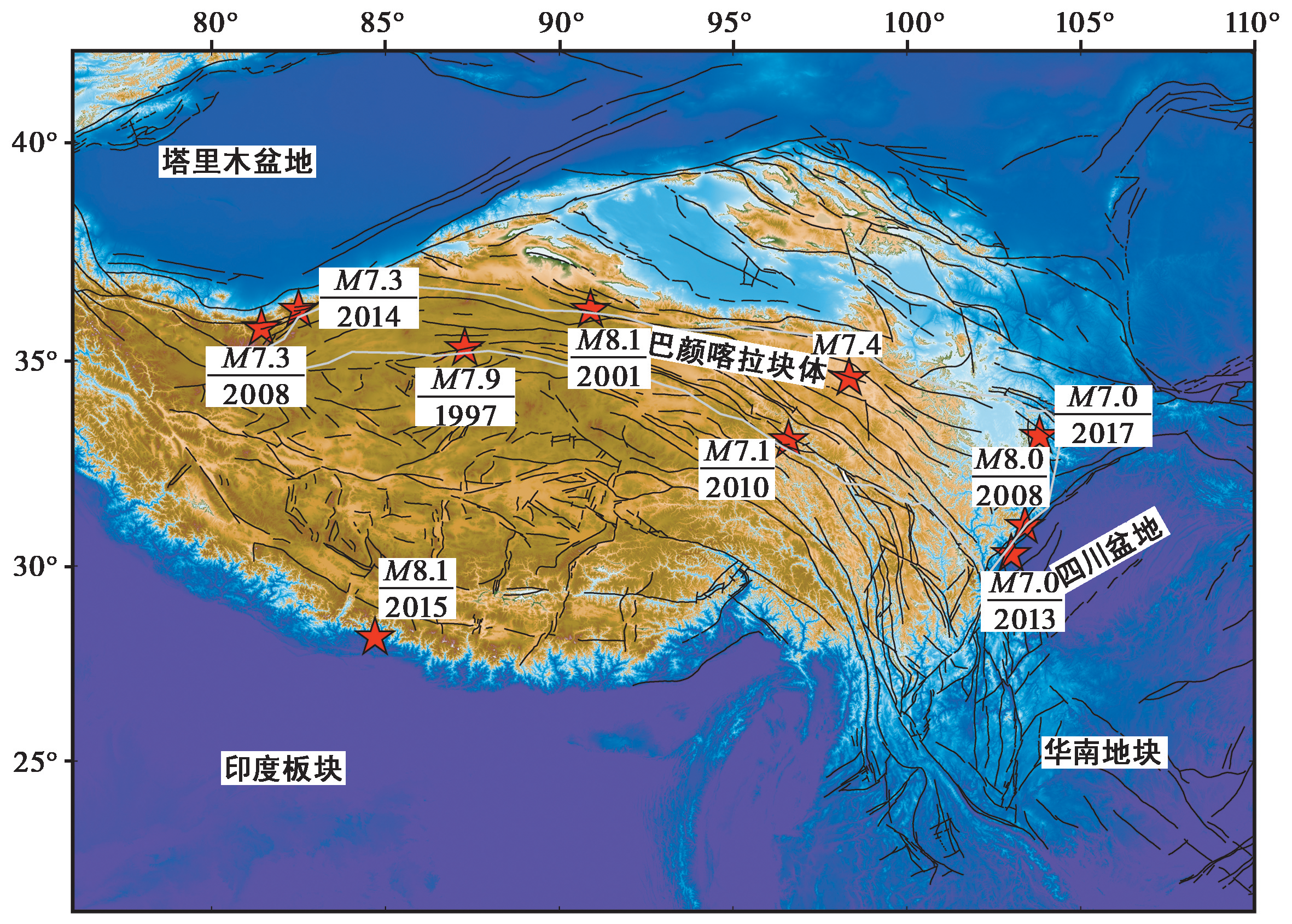
图1 巴颜喀拉块体及周缘7级以上大地震分布图 底图来自中国地质科学院地质研究所
Fig. 1 The distribution map of large earthquakes with M≥7 in Bayankala block and its periphery.

图2 震区的主要断裂及地震台站分布
Fig. 2 Spatial distribution of main faults and stations in the earthquake area.
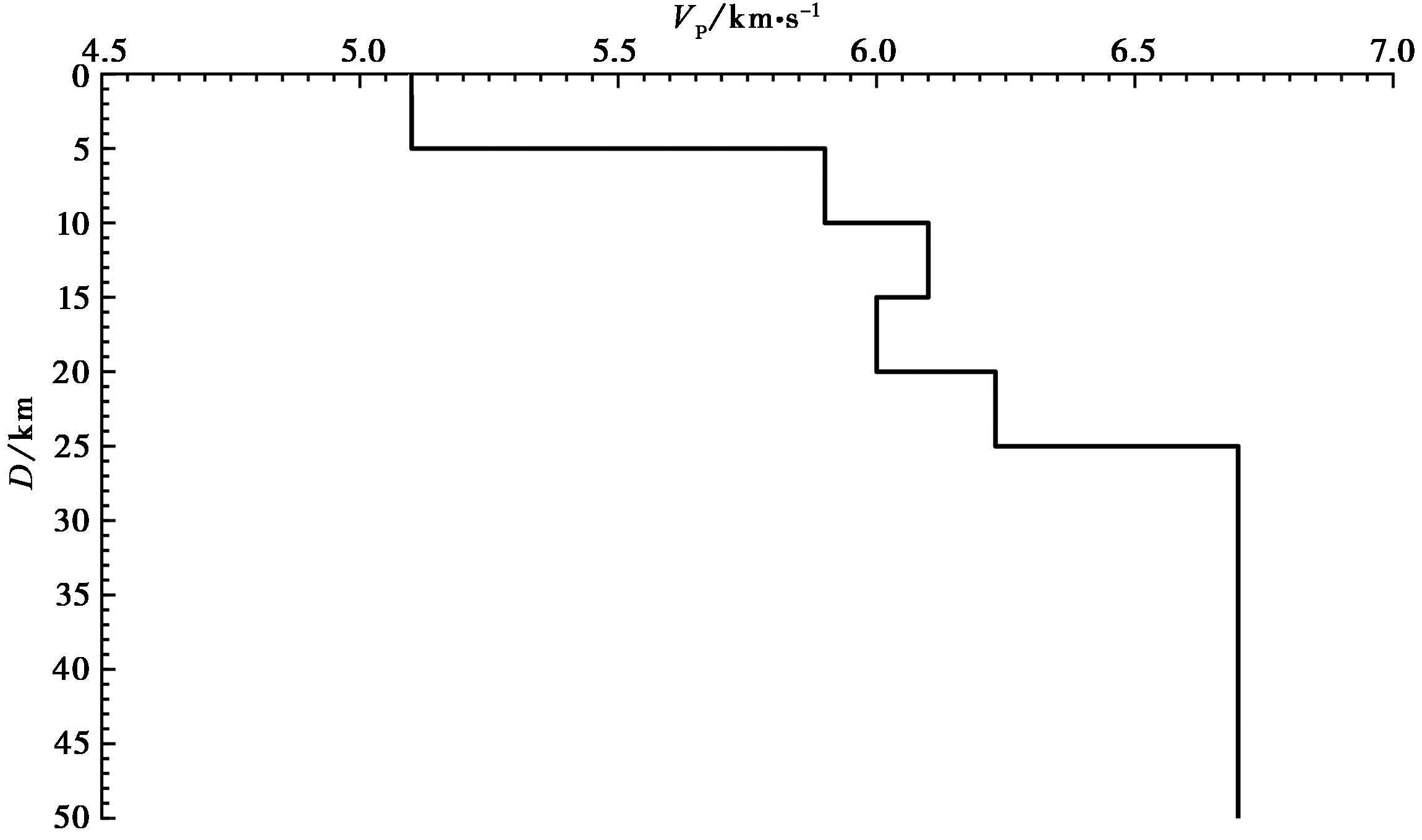
图3 双差定位采用的初始一维P波速度模型
Fig. 3 1-D initial velocity model used for double difference relocation.
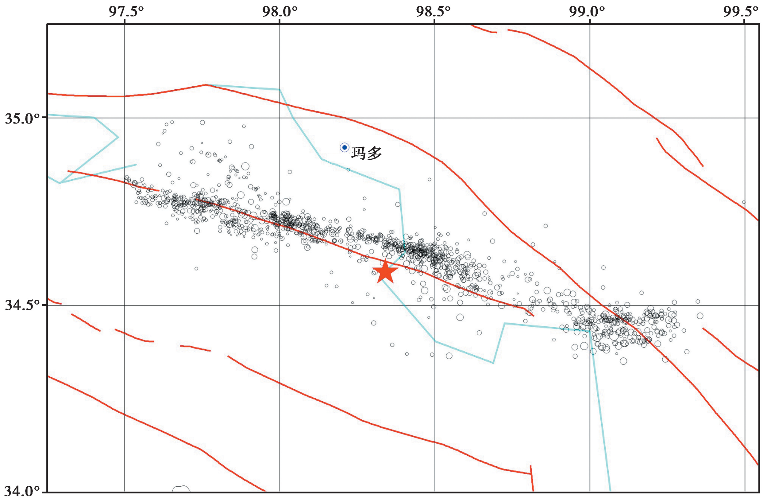
图4 研究区重新定位前的小地震震中分布图
Fig. 4 Map view of microseismicity before relocation in the research area.
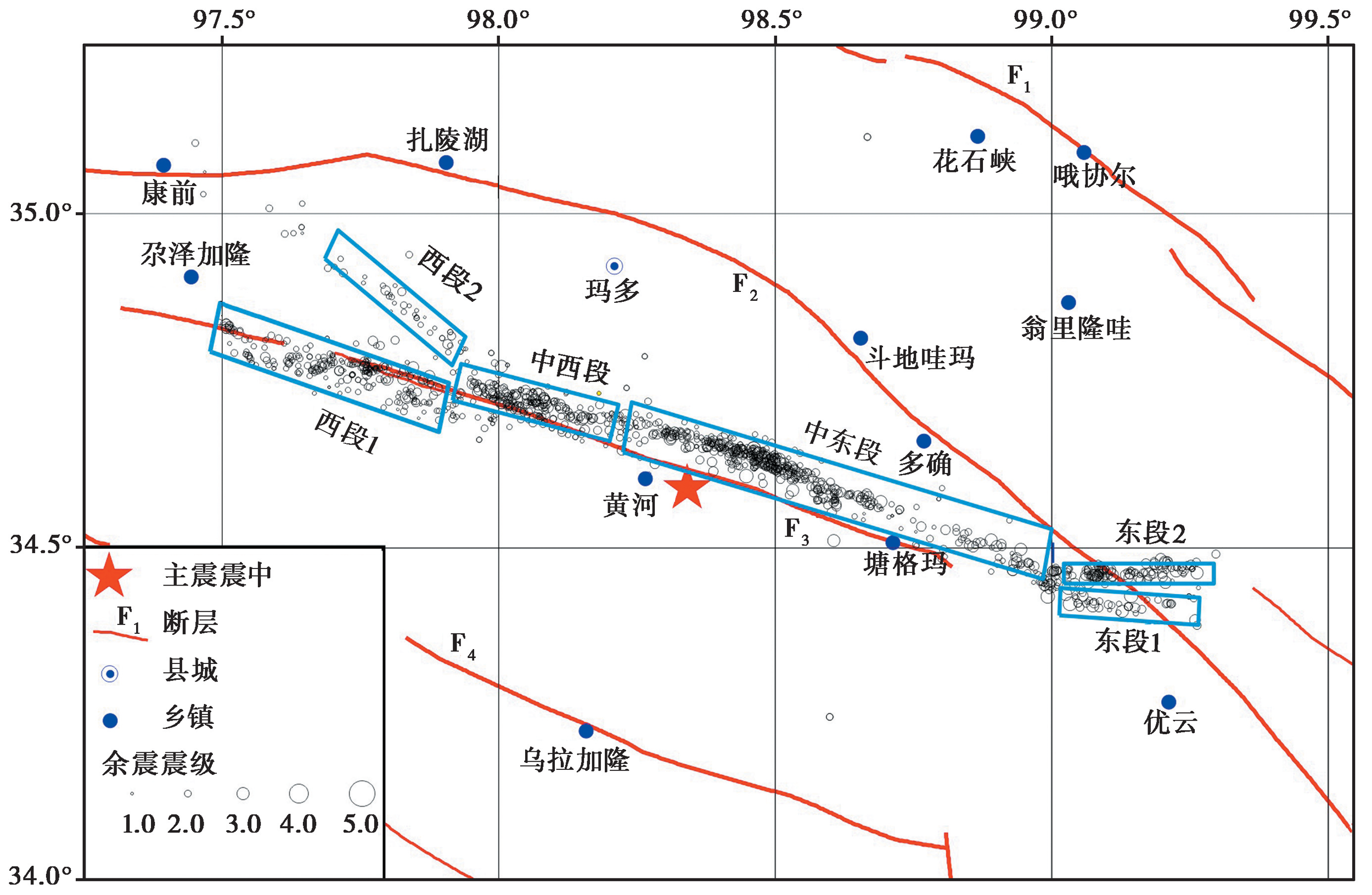
图5 研究区重新定位后的小地震震中分布图 粗线青色矩形框为不同的反演区域段。F1东昆仑断裂; F2昆仑山口-江错断裂; F3玛多-甘德断裂; F4达日断裂
Fig. 5 Map view of microseismicity after relocation in the research area.
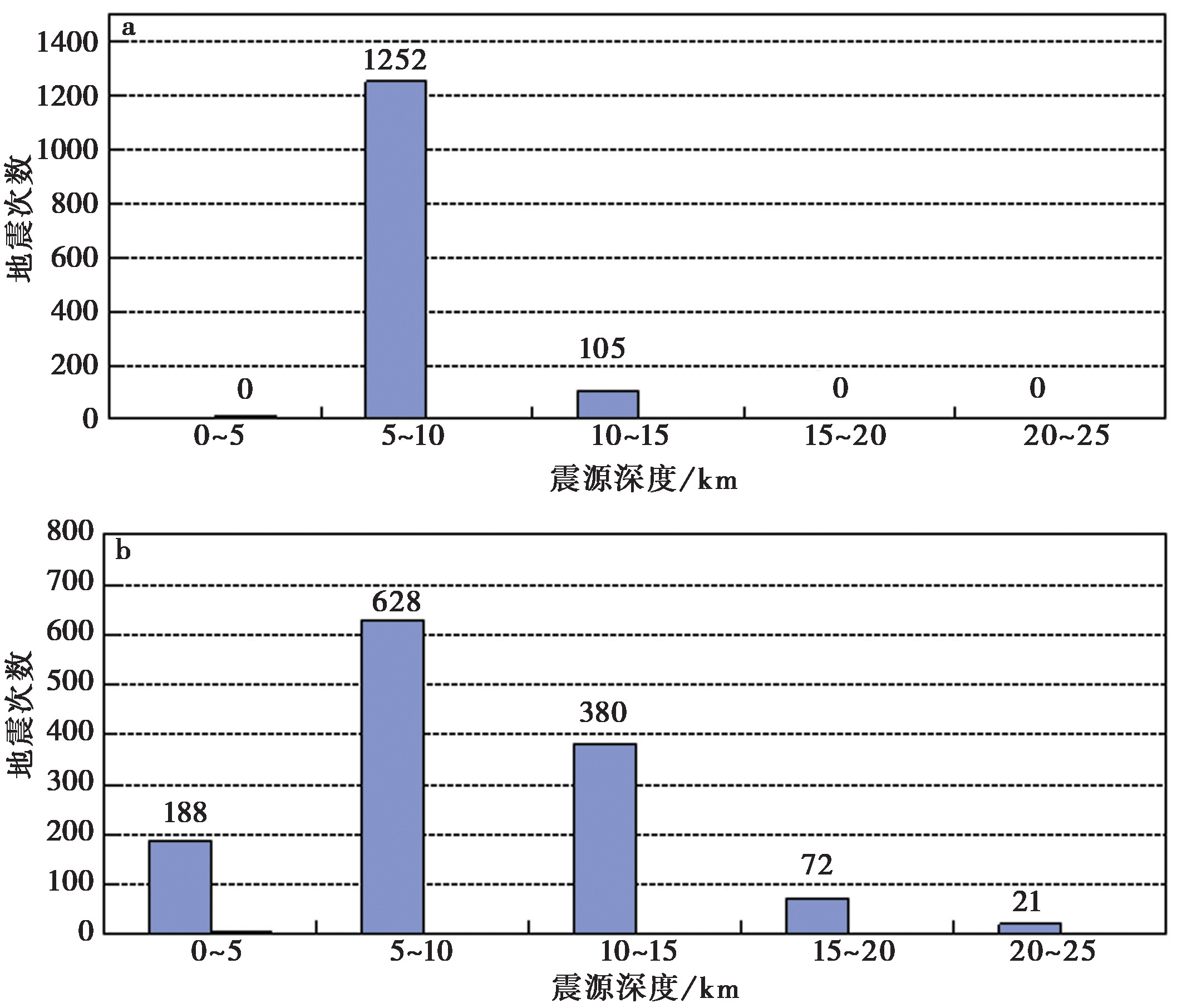
图6 研究区小地震重新定位前(a)、后(b)的震源深度统计图
Fig. 6 Statistics of focal depths of small earthquakes before(a)and after(b)relocation in the research area.
| 位置 | 地震 个数 | 走向 | 倾角 | 距离 | 滑动角 /(°) | 断层面顶点位置 | |||||
|---|---|---|---|---|---|---|---|---|---|---|---|
| 数值 /(°) | 标准差 /(°) | 数值 /(°) | 标准差 /(°) | 数值 /(°) | 标准差 /(°) | 北纬 /(°) | 东经 /(°) | 深度 /km | |||
| 西段1 | 244 | 285 | 0.6 | 85 | 1.2 | 0 | 0.1 | 14.6 | 34.81 | 97.54 | 3.1 |
| 34.79 | 97.53 | 24.1 | |||||||||
| 34.71 | 97.92 | 24.1 | |||||||||
| 34.72 | 97.93 | 3.1 | |||||||||
| 西段2 | 41 | 306 | 1.1 | 87.9 | 1.7 | 0 | 0.1 | 149.9 | 34.79 | 97.94 | 2.8 |
| 34.8 | 97.94 | 18.2 | |||||||||
| 34.92 | 97.73 | 18.2 | |||||||||
| 34.92 | 97.72 | 2.8 | |||||||||
| 中西段 | 219 | 286.7 | 0.9 | 84.4 | 1.5 | 0 | 0.09 | 19.6 | 34.67 | 98.19 | 3.5 |
| 34.69 | 98.2 | 16.9 | |||||||||
| 34.75 | 97.96 | 16.9 | |||||||||
| 34.73 | 97.95 | 3.5 | |||||||||
| 中东段 | 472 | 290 | 0.2 | 83.5 | 0.7 | 0 | 0.05 | 23.9 | 34.49 | 98.91 | 3.8 |
| 34.5 | 98.91 | 13.9 | |||||||||
| 34.69 | 98.29 | 13.9 | |||||||||
| 34.68 | 98.28 | 3.8 | |||||||||
| 东段1 | 36 | 92.2 | 1.4 | 89.1 | 1.9 | 0 | 0.1 | 1.6 | 34.41 | 99.22 | 2.1 |
| 34.41 | 99.22 | 16.1 | |||||||||
| 34.42 | 99.04 | 16.1 | |||||||||
| 34.42 | 99.04 | 2.1 | |||||||||
| 东段2 | 119 | 87.7 | 0.6 | 89.1 | 1.1 | 0 | 0.07 | 1.4 | 34.46 | 99 | 3 |
| 34.46 | 99 | 15.8 | |||||||||
| 34.47 | 99.25 | 15.8 | |||||||||
| 34.47 | 99.25 | 3 |
表1 使用重新定位的余震资料拟合的断层面参数
Table1 Fault plane parameters determined using relocation results of aftershocks
| 位置 | 地震 个数 | 走向 | 倾角 | 距离 | 滑动角 /(°) | 断层面顶点位置 | |||||
|---|---|---|---|---|---|---|---|---|---|---|---|
| 数值 /(°) | 标准差 /(°) | 数值 /(°) | 标准差 /(°) | 数值 /(°) | 标准差 /(°) | 北纬 /(°) | 东经 /(°) | 深度 /km | |||
| 西段1 | 244 | 285 | 0.6 | 85 | 1.2 | 0 | 0.1 | 14.6 | 34.81 | 97.54 | 3.1 |
| 34.79 | 97.53 | 24.1 | |||||||||
| 34.71 | 97.92 | 24.1 | |||||||||
| 34.72 | 97.93 | 3.1 | |||||||||
| 西段2 | 41 | 306 | 1.1 | 87.9 | 1.7 | 0 | 0.1 | 149.9 | 34.79 | 97.94 | 2.8 |
| 34.8 | 97.94 | 18.2 | |||||||||
| 34.92 | 97.73 | 18.2 | |||||||||
| 34.92 | 97.72 | 2.8 | |||||||||
| 中西段 | 219 | 286.7 | 0.9 | 84.4 | 1.5 | 0 | 0.09 | 19.6 | 34.67 | 98.19 | 3.5 |
| 34.69 | 98.2 | 16.9 | |||||||||
| 34.75 | 97.96 | 16.9 | |||||||||
| 34.73 | 97.95 | 3.5 | |||||||||
| 中东段 | 472 | 290 | 0.2 | 83.5 | 0.7 | 0 | 0.05 | 23.9 | 34.49 | 98.91 | 3.8 |
| 34.5 | 98.91 | 13.9 | |||||||||
| 34.69 | 98.29 | 13.9 | |||||||||
| 34.68 | 98.28 | 3.8 | |||||||||
| 东段1 | 36 | 92.2 | 1.4 | 89.1 | 1.9 | 0 | 0.1 | 1.6 | 34.41 | 99.22 | 2.1 |
| 34.41 | 99.22 | 16.1 | |||||||||
| 34.42 | 99.04 | 16.1 | |||||||||
| 34.42 | 99.04 | 2.1 | |||||||||
| 东段2 | 119 | 87.7 | 0.6 | 89.1 | 1.1 | 0 | 0.07 | 1.4 | 34.46 | 99 | 3 |
| 34.46 | 99 | 15.8 | |||||||||
| 34.47 | 99.25 | 15.8 | |||||||||
| 34.47 | 99.25 | 3 |
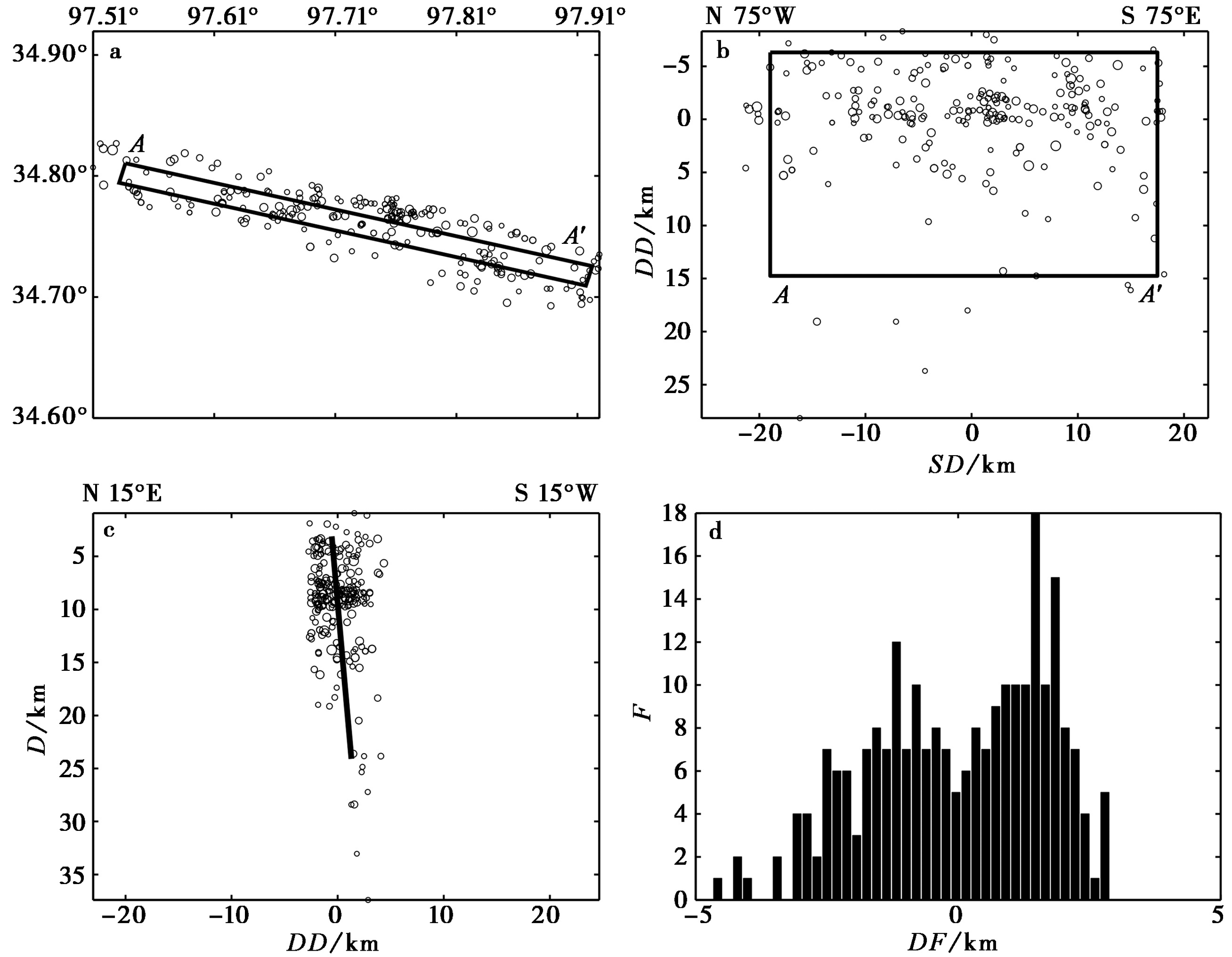
图7 昆仑山口-江错断裂西段1重定位的小地震分布 a 在平面方向上的投影; b 在竖向上的投影; c 在断面上的投影; d 小地震距离断层面的情况。圆圈表示重定位后的余震, 粗线为拟合断层面的边界; AA'为边界端点; SD是走向, DD是倾向, DF是余震与断层面之间的距离, F为频度
Fig. 7 Distribution of the relocated aftershocks near the western segment 1 of the Kunlun Mountains Pass-Jiangcuo Fault.
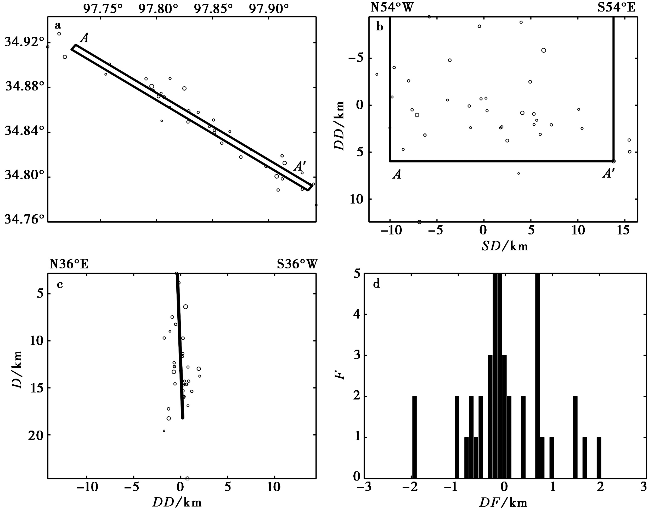
图8 昆仑山口-江错断裂西段2重定位后的小地震分布 其余说明与图 7相同
Fig. 8 Distribution of the relocated aftershocks near the western segment 2 of the Kunlun Mountains Pass-Jiangcuo Fault.
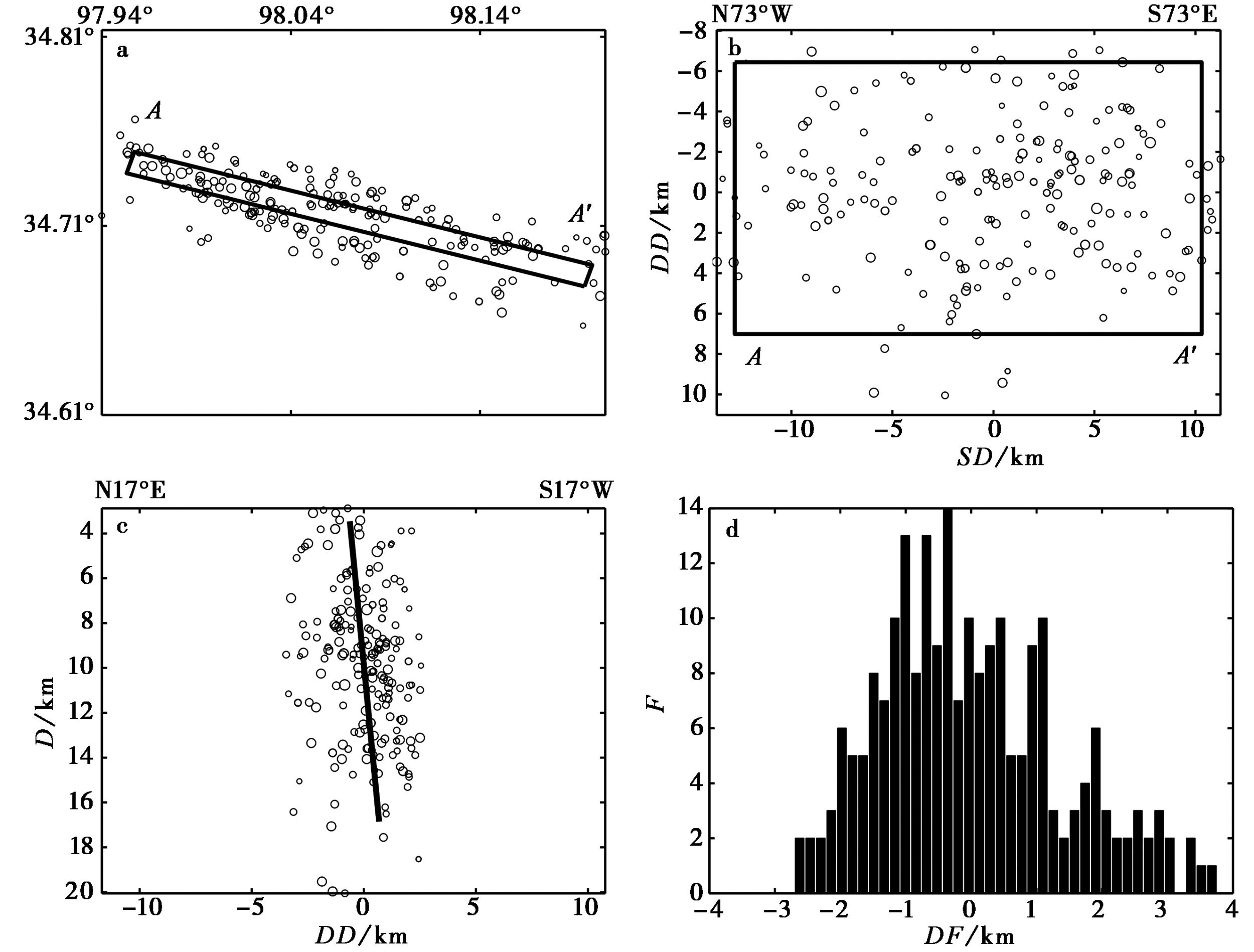
图9 昆仑山口-江错断裂中西段重定位后的小地震分布 其余说明与图7相同
Fig. 9 Distribution of the relocated aftershocks near the central and western segment of the Kunlun Mountains Pass-Jiangcuo Fault.
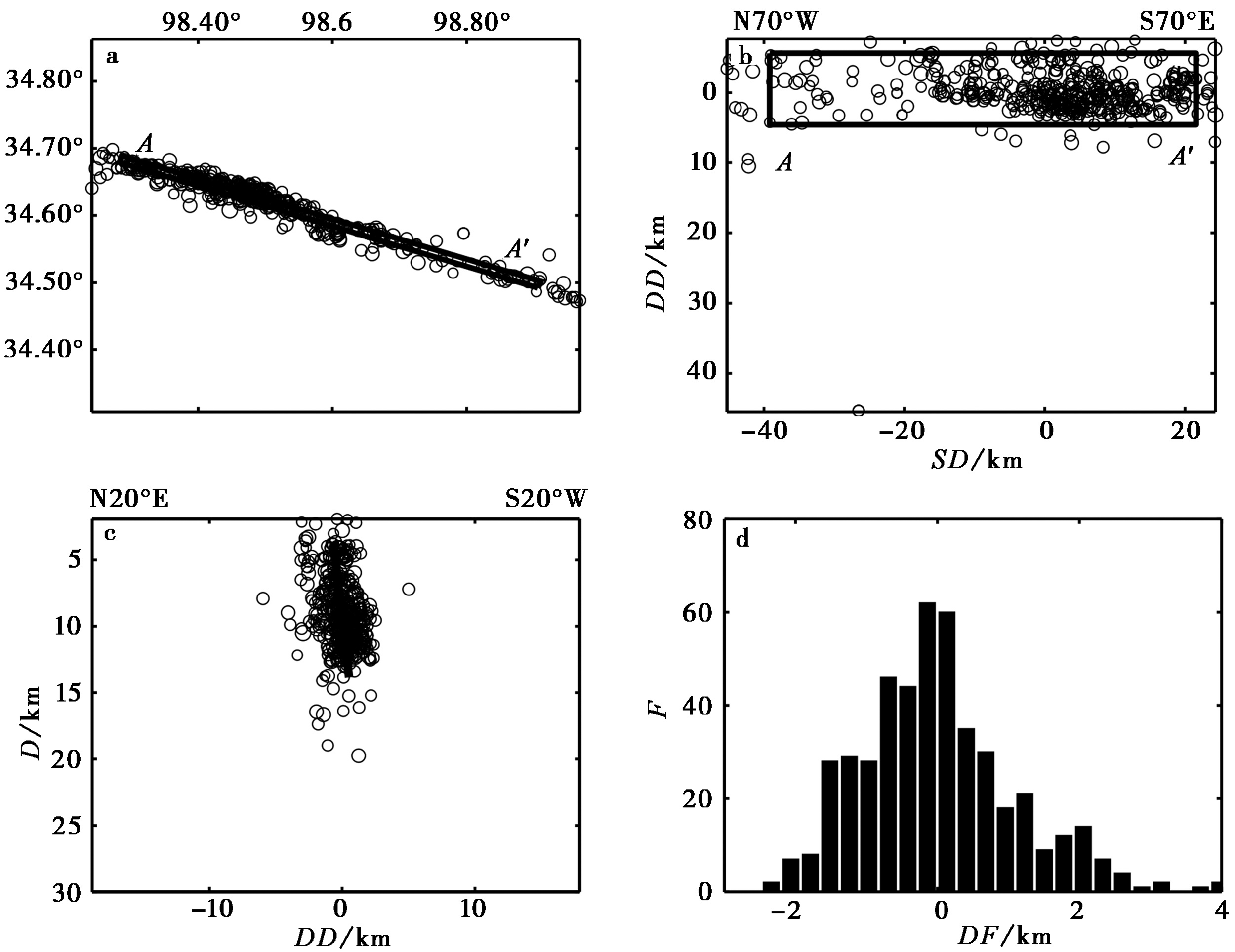
图10 昆仑山口-江错断裂中东段重定位后的小地震分布 其余说明与图7相同
Fig. 10 Distribution of the relocated aftershocks near the central and eastern segment of the Kunlun Mountains Pass-Jiangcuo Fault.
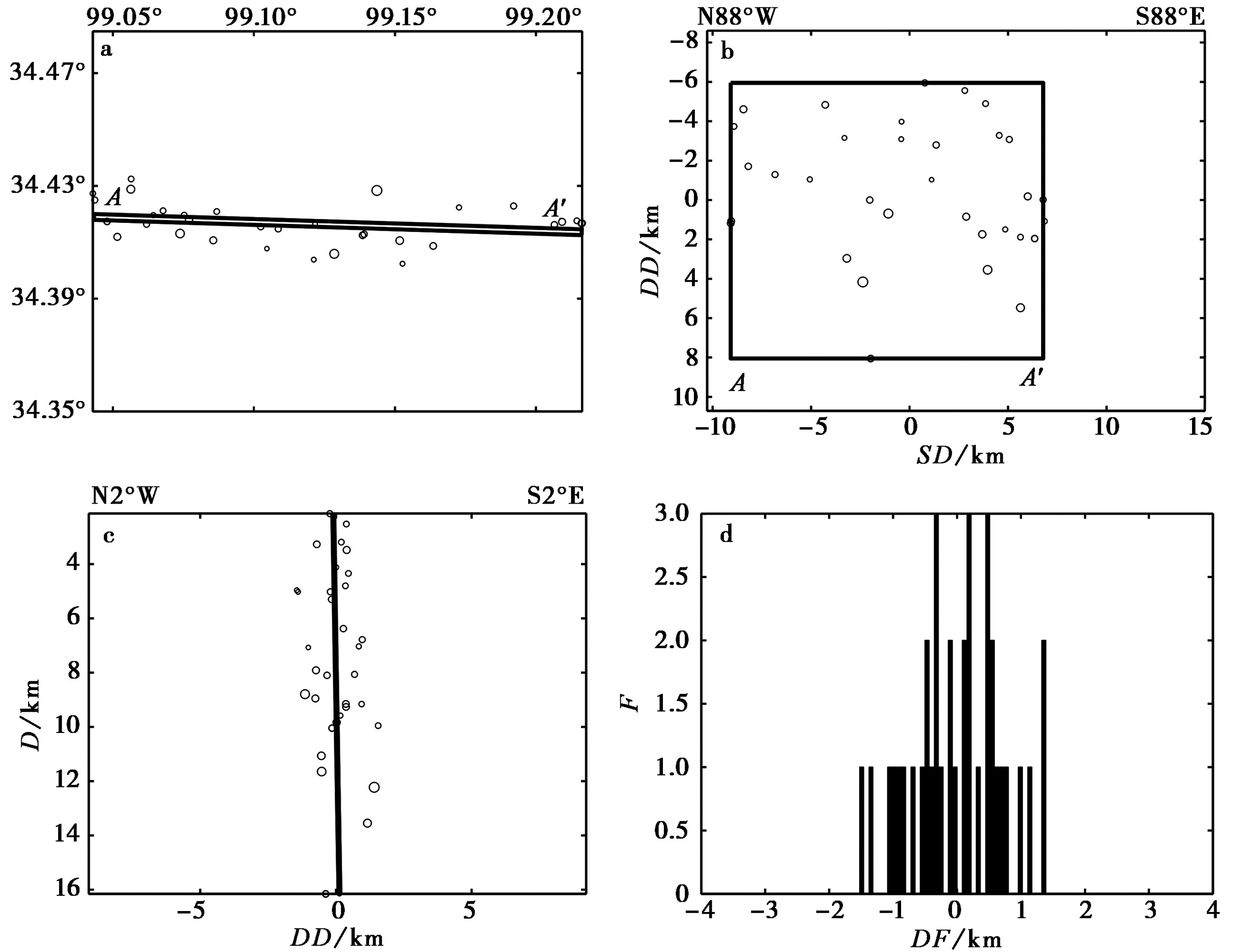
图11 昆仑山口-江错断裂东段1重定位后的小地震分布 其余说明与图7相同
Fig. 11 Distribution of the relocated aftershocks near the eastern segment 1 of the Kunlun Mountains Pass-Jiangcuo Fault.
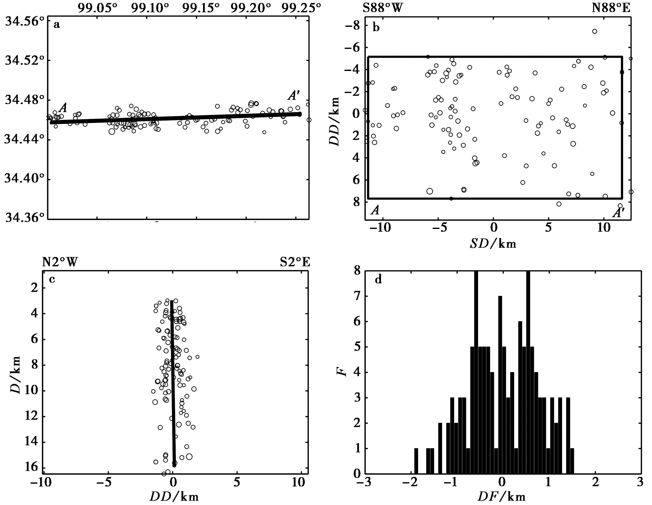
图12 昆仑山口-江错断裂中东段2重定位后的小地震分布 其余说明与图7相同
Fig. 12 Distribution of the relocated aftershocks near the eastern segment 2 of the Kunlun Mountains Pass-Jiangcuo Fault.
| P轴 | T轴 | R | ||
|---|---|---|---|---|
| 方位 | 倾伏角 | 方位 | 倾伏角 | 0.96 |
| 212° | 6° | 304° | 22° |
表2 研究区局部应力场参数
Table2 Regional stress field of Maduo area
| P轴 | T轴 | R | ||
|---|---|---|---|---|
| 方位 | 倾伏角 | 方位 | 倾伏角 | 0.96 |
| 212° | 6° | 304° | 22° |
| 序号 | 机构或作者 | 震源机制解 | ||
|---|---|---|---|---|
| 走向/(°) | 倾角/(°) | 滑动角/(°) | ||
| 1 | 王卫民 | 103.1 | 83.5 | 6.5 |
| 2 | 中国地震台网中心 | 102 | 81 | -11 |
| 3 | USGS | 92 | 67 | -40 |
| 4 | GCMT | 282 | 83 | -9 |
| 5 | CPPT | 104 | 75 | 14 |
| 6 | GFZ | 102 | 84 | -3 |
| 7 | 中国地震局地球物理研究所 | 101 | 87 | -7 |
表3 不同科研单位给出青海玛多县M7.4地震震源机制解参数①(① https://:ses-kled.cidp.edu.cn/info/1084/1265.htm)
Table3 The parameters of focal mechanism solutions of Maduo M7.4 earthquake from different scientific research institutions①(① https://:ses-kled.cidp.edu.cn/info/1084/1265.htm)
| 序号 | 机构或作者 | 震源机制解 | ||
|---|---|---|---|---|
| 走向/(°) | 倾角/(°) | 滑动角/(°) | ||
| 1 | 王卫民 | 103.1 | 83.5 | 6.5 |
| 2 | 中国地震台网中心 | 102 | 81 | -11 |
| 3 | USGS | 92 | 67 | -40 |
| 4 | GCMT | 282 | 83 | -9 |
| 5 | CPPT | 104 | 75 | 14 |
| 6 | GFZ | 102 | 84 | -3 |
| 7 | 中国地震局地球物理研究所 | 101 | 87 | -7 |
| [1] |
崔华伟, 郑建常, 张正帅, 等. 2020. 长岛地区小地震断层面参数拟合及应力场特征[J]. 地震地质, 42(6): 1432-1445. doi: 10.3969/j.issn.0253-4967.2020.06.011.
DOI |
| CUI Hua-wei, ZHENG Jian-chang, ZHANG Zheng-shuai, et al. 2020. Fitting the fault plane parameters with small earthquakes and the characteristics of stress field of Changdao area[J]. Seismology and Geology, 42(6): 1432-1445. (in Chinese) | |
| [2] | 董治平. 1990. 青海东部地区新生代构造应力场探讨[J]. 内陆地震, 4(3): 247-256. |
| DONG Zhi-ping. 1990. The analysis of Cenozoic stress field in the region of eastern Qinghai[J]. Inland Earthquake, 4(3): 247-256. (in Chinese) | |
| [3] |
华俊, 赵德政, 单新建, 等. 2021. 2021年青海玛多 MW7.3 地震InSAR的同震形变场、断层滑动分布及其对周边区域的应力扰动[J]. 地震地质, 43(3): 677-691. doi: 10.3969/j.issn.0253-4967.2021.03.013.
DOI |
| HUA Jun, ZHAO De-zheng, SHAN Xin-jian, et al. 2021. Coseismic deformation field, slip distribution and Coulomb stress disturbance of the 2021 MW7.3 Maduo earthquake using Sentinel-1 InSAR observations[J]. Seismology and Geology, 43(3): 677-691. (in Chinese) | |
| [4] | 李松林, 张先康, 张成科, 等. 2002. 玛沁-兰州-靖边地震测深剖面地壳速度结构的初步研究[J]. 地球物理学报, 45(2): 210-217. |
| LI Song-lin, ZHANG Xian-kang, ZHANG Cheng-ke, et al. 2002. A preliminary study on the crustal velocity structure of Maqin-Lanzhou-Jingbian by means of deep seismic sounding profile[J]. Chinese Journal of Geophysics, 45(2): 210-217. (in Chinese) | |
| [5] |
刘白云, 尹志文, 袁道阳, 等. 2020. 青藏高原东北缘老虎山断裂的断层面参数拟合及其几何意义[J]. 地震地质, 42(6): 1354-1369. doi: 10.3969/j.issn.0253-4967.2020.06.006.
DOI |
| LIU Bai-yun, YIN Zhi-wen, YUAN Dao-yang, et al. 2020. The research on fault plane solution and geometric meaning of the Laohushan Fault in the northeastern Tibetan plateau[J]. Seismology and Geology, 42(6): 1354-1369. (in Chinese) | |
| [6] |
刘白云, 袁道阳, 张波, 等. 2012. 1879年武都南8级大地震断层面参数和滑动性质的厘定[J]. 地震地质, 34(3): 415-424. doi: 10.3969/j.issn.0253-4967.2012.03.003.
DOI |
| LIU Bai-yun, YUAN Dao-yang, ZHANG Bo, et al. 2012. Determination of fault parameters and sliding behavior of the 1879 southern Wudu M8.0 earthquake[J]. Seismology and Geology, 34(3): 415-424. (in Chinese) | |
| [7] | 刘白云, 曾文浩, 袁道阳, 等. 2014. 1954年腾格里沙漠北7级地震断层面参数和滑动性质研究[J]. 地震工程学报, 36(3): 622-627. |
| LIU Bai-yun, ZENG Wen-hao, YUAN Dao-yang, et al. 2014. Fault parameters and slip properties of the 1954 northern Tengger desert M7.0 earthquake[J]. China Earthquake Engineering Journal, 36(3): 622-627. (in Chinese) | |
| [8] |
刘白云, 曾文浩, 袁道阳, 等. 2015. 1927年古浪8级大地震断层面参数和滑动性质[J]. 地震地质, 37(3): 818-828. doi: 103969/j.issn.0253-4967.2015.03.012.
DOI |
| LIU Bai-yun, ZENG Wen-hao, YUAN Dao-yang, et al. 2015. The research on fault parameter and sliding behavior of the 1927 Gulang M8.0 earthquake[J]. Seismology and Geology, 37(3): 818-828. (in Chinese) | |
| [9] | 潘家伟, 白明坤, 李超, 等. 2021. 2021年5月22日青海玛多 MS7.4 地震地表破裂带及发震构造[J]. 地质学报, 95(6): 1655-1670. |
| PAN Jia-wei, BAI Ming-kun, LI Chao, et al. 2021. Coseismic surface rupture and seismogenic structure of the 2021-05-22 Maduo(Qinghai) MS7.4 earthquake[J]. Acta Geologica Sinica, 95(6): 1655-1670. (in Chinese) | |
| [10] | 孙庆山, 盛书中, 万永革, 等. 2016. 2014 年云南鲁甸 MS6.5 地震断层面参数的确定[J]. 内陆地震, 30(1): 66-73. |
| SUN Qing-shan, SHENG Shu-zhong, WAN Yong-ge, et al. 2016. Fault plane parameter determination of Yunnan Ludian MS6.5 earthquake in 2014[J]. Inland Earthquake, 30(1): 66-73. (in Chinese) | |
| [11] | 万永革, 沈正康, 刁桂苓, 等. 2008. 利用小震分布和区域应力场确定大震断层面参数方法及其在唐山地震序列中的应用[J]. 地球物理学报, 51(3): 793-804. |
| WAN Yong-ge, SHEN Zheng-kang, DIAO Gui-ling, et al. 2008. An algorithm of fault parameter determination using distribution of small earthquakes and parameters of regional stress field and its application to Tangshan earthquake sequence[J]. Chinese Journal of Geophysics, 51(3): 793-804. (in Chinese) | |
| [12] | 王未来, 房立华, 吴建平, 等. 2021. 2021年青海玛多 MS7.4 地震序列精定位研究[J]. 中国科学(D辑), 51(7): 1193-1202. |
| WANG Wei-lai, FANG Li-hua, WU Jian-ping, et al. 2021. Aftershock sequence relocation of the 2021 MS7.4 Maduo earthquake, Qinghai, China[J]. Science in China(Ser D), 51(7): 1193-1202. (in Chinese) | |
| [13] | 徐旭, 徐锦承, 张伟. 2020. 2017年四川九寨沟 MS7.0 地震及余震定位研究[J]. 中国地震, 36(2): 324-332. |
| XU Xu, XU Jin-cheng, ZHANG Wei. 2020. Relocation of main shock and aftershocks of the MS7.0 Sichuan Jiuzhaigou earthquake[J]. Earthquake Research in China, 36(2): 324-332. (in Chinese) | |
| [14] | 徐志国, 梁姍姍, 张广伟, 等. 2021. 2021年5月22日青海玛多 MS7.4 地震发震构造分析[J]. 地球物理学报, 64(8): 2657-2670. |
| XU Zhi-guo, LIANG Shan-shan, ZHANG Guang-wei, et al. 2021. Analysis of seismogenic structure of Maduo, Qinghai MS7.4 earthquake on May 22, 2021[J]. Chinese Journal of Geophysics, 64(8): 2657-2670. (in Chinese) | |
| [15] | 徐志双, 刘杰, 郑通彦, 等. 2020. 基于精定位余震序列的2019年四川长宁 MS6.0 地震等震线研究[J]. 地震学报, 42(4): 447-456. |
| XU Zhi-shuang, LIU Jie, ZHENG Tong-yan, et al. 2020. Isoseismal line of Sichuan Changning MS6.0 earthquake in 2019 based on precisely located aftershocks sequence[J]. Acta Seismologica Sinica, 42(4): 447-456. (in Chinese) | |
| [16] |
阎春恒, 周斌, 李莎, 等. 2020. 利用小震分布和区域应力场确定龙滩库区地震断层面参数[J]. 地震地质, 42(3): 562-579. doi: 10.3969/j.issn.0253-4967.2020.03.002.
DOI |
| YAN Chun-heng, ZHOU Bin, LI Sha, et al. 2020. Determination of fault plane parameters in the Longtan reservoir by using precisely located small earthquake data and regional stress field[J]. Seismology and Geology, 42(3): 562-579. (in Chinese) | |
| [17] | 詹艳, 梁明剑, 孙翔宇, 等. 2021. 2021年5月22日青海玛多 MS7.4 地震深部环境及发震构造模式[J]. 地球物理学报, 64(7): 2232-2252. |
| ZHAN Yan, LIANG Ming-jian, SUN Xiang-yu, et al. 2021. Deep structure and seismogenic pattern of the 2021.5. 22 Madoi(Qinghai) MS7.4 earthquake[J]. Chinese Journal of Geophysics, 64(7): 2232-2252. (in Chinese) | |
| [18] | 赵博, 高原, 马延路. 2022. 2021年5月21日云南漾濞 MS6.4 地震序列重新定位、 震源机制及应力场反演[J]. 地球物理学报, 65(3): 1006-1020. |
| ZHAO Bo, GAO Yuan, MA Yan-lu, 2022. Relocations, focal mechanisms and stress inversion of the May 21th 2021 Yangbi MS6.4 earthquake sequence in Yunnan, China[J]. Chinese Journal of Geophysics, 65(3): 1006-1020. (in Chinese) | |
| [19] | 周民都. 2006. 青藏高原东北缘深地震测深研究成果回顾[J]. 西北地震学报, 28(2): 189-191. |
| ZHOU Min-du. 2006. Review of study on the depth seismic sounding in the northeastern margin of Qinghai-Tibetan plateau[J]. Northwestern Seismological Journal, 28(2): 189-191. (in Chinese) | |
| [20] | Schaff D P, Bokelmann G H R, Beroza G C, et al. 2002. High-resolution image of Calaveras fault seismicity[J]. Journal of Geophysical Research, 107(B9): ESE5-1-ESE5-16. |
| [21] | Waldhauser F, Ellsworth W L. 2002. Fault structure and mechanics of the Hayward Fault, California, from double-difference earthquake locations[J]. Journal of Geophysical Research: Solid Earth, 107(B3): ESE3-1-ESE3-15. |
| [1] | 赵德政, 屈春燕, 张桂芳, 龚文瑜, 单新建, 朱传华, 张国宏, 宋小刚. 基于InSAR技术的同震形变获取、地震应急监测和发震构造研究应用进展[J]. 地震地质, 2023, 45(2): 570-592. |
| [2] | 张珂, 王鑫, 杨红樱, 王玥, 徐岩, 李静. 2021年云南漾濞MS6.4地震序列特征及其发震构造分析[J]. 地震地质, 2023, 45(1): 231-251. |
| [3] | 李传友, 孙凯, 马骏, 李俊杰, 梁明剑, 房立华. 四川泸定6.8级地震--鲜水河断裂带磨西段局部发起、 全段参与的一次复杂事件[J]. 地震地质, 2022, 44(6): 1648-1666. |
| [4] | 张博譞, 郑文俊, 陈杰, 何骁慧, 李启雷, 张冬丽, 段磊, 陈干. 柴达木盆地北部2021年6月16日青海茫崖MS5.8地震发震构造分析[J]. 地震地质, 2022, 44(5): 1313-1332. |
| [5] | 姚生海, 盖海龙, 殷翔, 刘炜, 张加庆, 袁建新. 阿木尼克山山前地表破裂带与1962年6.8级地震关系的讨论[J]. 地震地质, 2022, 44(4): 976-991. |
| [6] | 余占洋, 沈旭章, 梁浩, 郑文俊, 刘旭宙. 基于地震活动性和震源机制解研究渭河-运城盆地主要断裂带的特征及应力场分布[J]. 地震地质, 2022, 44(2): 395-413. |
| [7] | 梁宽, 何仲太, 姜文亮, 李永生, 刘泽民. 2022年1月8日青海门源MS6.9地震的同震地表破裂特征[J]. 地震地质, 2022, 44(1): 256-278. |
| [8] | 高帆, 韩竹军, 袁仁茂, 董绍鹏, 郭鹏. 滇东南地区小江断裂南段历史滑坡特征及其地震地质意义[J]. 地震地质, 2021, 43(6): 1412-1434. |
| [9] | 姚生海, 盖海龙, 殷翔, 李鑫. 青海玛多MS7.4地震地表破裂带的基本特征和典型现象[J]. 地震地质, 2021, 43(5): 1060-1072. |
| [10] | 赵韬, 王莹, 马冀, 邵若潼, 徐一斐, 胡景. 2021年青海玛多7.4级地震序列重定位和震源机制特征[J]. 地震地质, 2021, 43(4): 790-805. |
| [11] | 王莹, 赵韬, 胡景, 刘春. 2021年云南漾濞6.4级地震序列重定位及震源机制解特征分析[J]. 地震地质, 2021, 43(4): 847-863. |
| [12] | 贾蕊, 张国宏, 解朝娣, 单新建, 张迎峰, 李成龙, 黄自成. 2019年巴基斯坦新米尔普尔MW6.0地震的同震形变场与断层滑动分布反演[J]. 地震地质, 2021, 43(3): 600-613. |
| [13] | 赵启光, 孙业君, 黄耘, 杨伟林, 顾勤平, 孟科, 杨浩. 高邮-宝应MS4.9地震的发震构造[J]. 地震地质, 2021, 43(3): 630-646. |
| [14] | 李传友, 张金玉, 王伟, 孙凯, 单新建. 2021年云南漾濞6.4级地震发震构造分析[J]. 地震地质, 2021, 43(3): 706-721. |
| [15] | 崔仁胜, 赵翠萍, 周连庆, 陈阳. 2020年1月19日新疆伽师MS6.4地震序列的活动特征和发震构造[J]. 地震地质, 2021, 43(2): 329-344. |
| 阅读次数 | ||||||
|
全文 |
|
|||||
|
摘要 |
|
|||||
