地震地质 ›› 2023, Vol. 45 ›› Issue (2): 570-592.DOI: 10.3969/j.issn.0253-4967.2023.02.016
• 综述 • 上一篇
赵德政1)( ), 屈春燕1),*(), 张桂芳1), 龚文瑜1), 单新建1), 朱传华2), 张国宏1), 宋小刚1)
修回日期:2022-09-21
出版日期:2023-04-20
发布日期:2023-05-18
通讯作者:
*屈春燕, 女, 1966年生, 博士, 研究员, 主要研究方向为InSAR地壳形变与模拟, E-mail: 作者简介:赵德政, 男, 1992年生, 2021年于中国地震局地质研究所获地球物理专业博士学位, 现为中国地震局地质研究所博士后, 主要研究方向为地震周期形变与断层运动学, E-mail: dezhengzhao@ies.ac.cn。
基金资助:
ZHAO De-zheng1)(), QU Chun-yan1),*(), ZHANG Gui-fang1), GONG Wen-yu1), SHAN Xin-jian1), ZHU Chuan-hua2), ZHANG Guo-hong1), SONG Xiao-gang1)
Revised:2022-09-21
Online:2023-04-20
Published:2023-05-18
摘要:
随着大地测量观测理论、观测平台和观测技术的发展与进步, InSAR作为一种新型的遥感地质观测途径和数据源, 在同震形变获取、地震应急监测、抗震救灾和发震构造科学研究中发挥了越来越重要和不可替代的作用。其中, InSAR在同震形变监测中的应用最为广泛, 能够在重要灾害性地震事件发生后及时响应, 在识别隐伏断层、确定发震断层、监测地表破裂、研究发震断层的运动学特征、获取三维形变以及厘定发震构造等问题中能提供有效的地表观测数据和模型约束。InSAR观测以其大范围、高精度、及时性等技术和数据优势, 在地震应急观测方面的科技支撑作用逐渐凸显, 能解决防震减灾的实际需求并逐渐趋于业务化。梳理近年来InSAR技术在不同活动构造区和地震危险区地震周期形变监测中的应用、分析基于InSAR同震形变观测的断层运动学特征和发震构造研究、讨论InSAR技术的前沿发展趋势, 能更好地服务于当前青藏高原及周边广大地区的防震减灾事业, 有助于实现活动断层的地震危险性评估等科学目标。基于此, 文中简要综述了近20年来InSAR技术在同震形变获取、应用中的现状、业务化、科学认识和存在的问题。
中图分类号:
赵德政, 屈春燕, 张桂芳, 龚文瑜, 单新建, 朱传华, 张国宏, 宋小刚. 基于InSAR技术的同震形变获取、地震应急监测和发震构造研究应用进展[J]. 地震地质, 2023, 45(2): 570-592.
ZHAO De-zheng, QU Chun-yan, ZHANG Gui-fang, GONG Wen-yu, SHAN Xin-jian, ZHU Chuan-hua, ZHANG Guo-hong, SONG Xiao-gang. APPLICATIONS AND ADVANCES FOR THE COSEISMIC DEFORMA-TION OBSERVATIONS, EARTHQUAKE EMERGENCY RESPONSE AND SEISMOGENIC STRUCTURE INVESTIGATION USING INSAR[J]. SEISMOLOGY AND GEOLOGY, 2023, 45(2): 570-592.

图1 青藏高原及周边地区的历史地震、断裂带、块体、人口分布图 红色震源球: MW>7; 绿色震源球: 7>MW>6; 蓝色震源球: 6>MW>5。 黑色圆圈为1970年以前的历史地震震中(数据来自中国地震台网地震目录); 黑色实线为断裂带; 浅蓝色实线为块体边界; 底图为人口数量分布①(①http://sedac.ciesin.columbia.edu/gpw。)
Fig. 1 Historical earthquakes, active faults, blocks, and population distribution within the Qinghai-Tibetan plateau and surrounding regions.
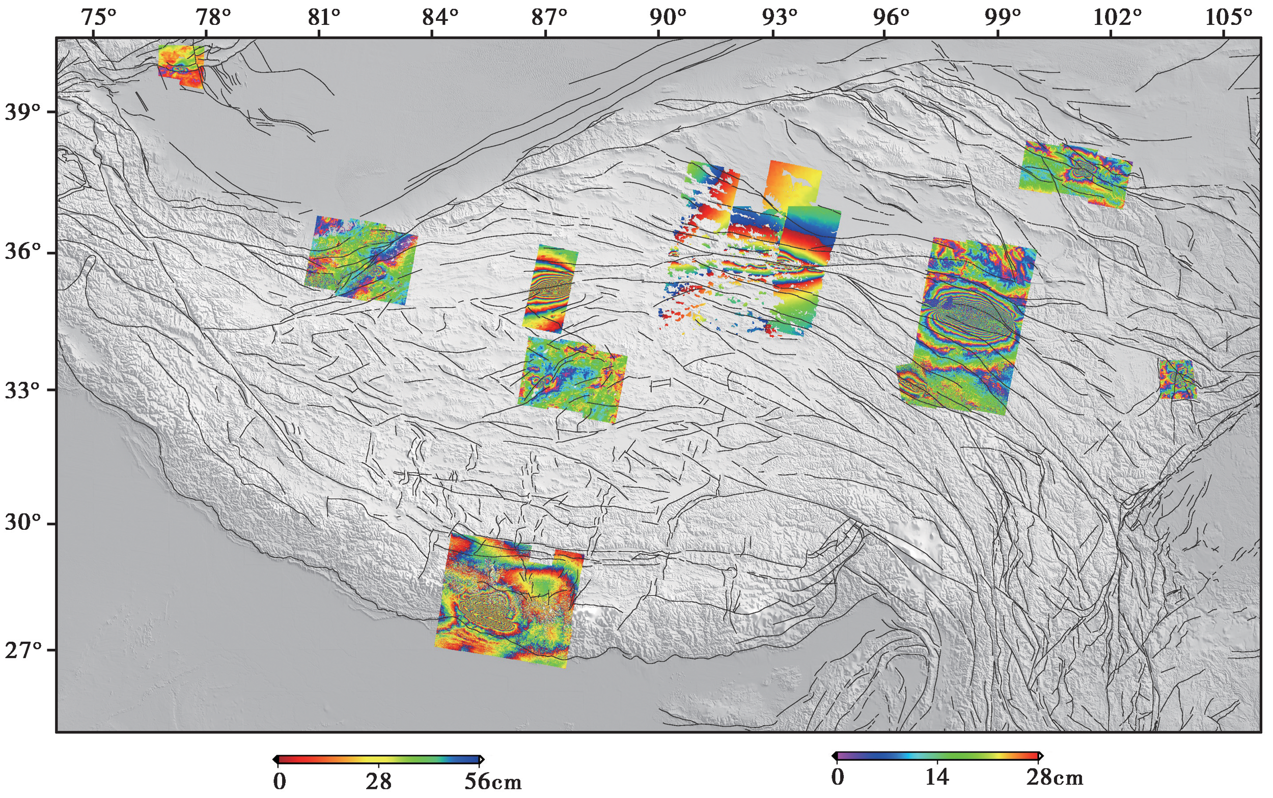
图2 青藏高原及周边地区部分地震(M>6)的InSAR干涉图条纹图 图中色标为缠绕干涉图(Unwrapped interferogram)标尺, 单位为cm
Fig. 2 Collage of coseismic InSAR interferograms of some earthquakes within the Qinghai-Tibetan plateau and surrounding regions.
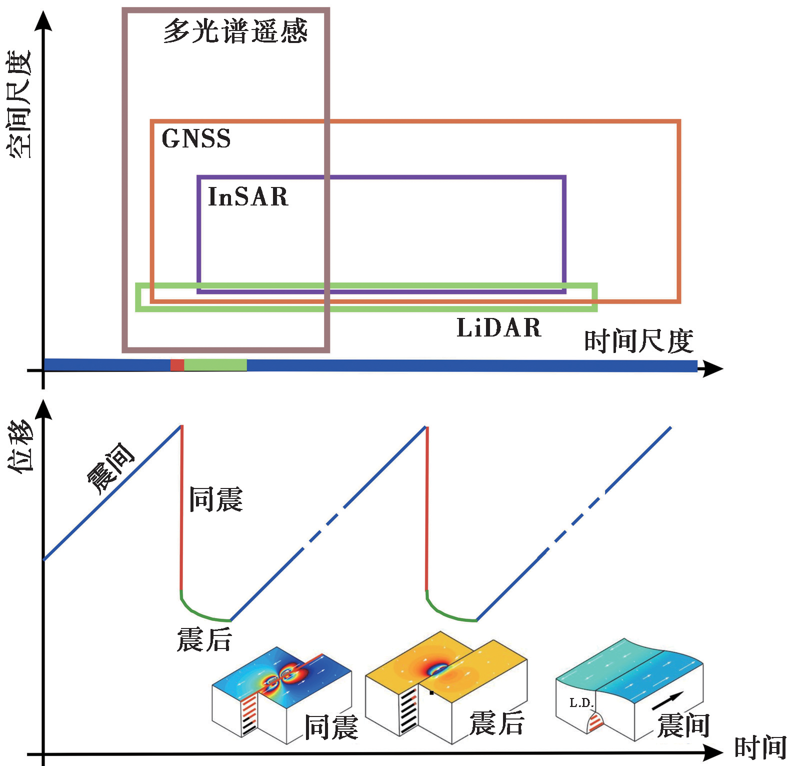
图3 利用不同数据源研究地震形变的时空尺度和理想化的地震周期形变过程示意图
Fig. 3 Spatio-temporal scale of diverse data sources used to observe earthquake deformation and schematics of earthquake cycle deformation.
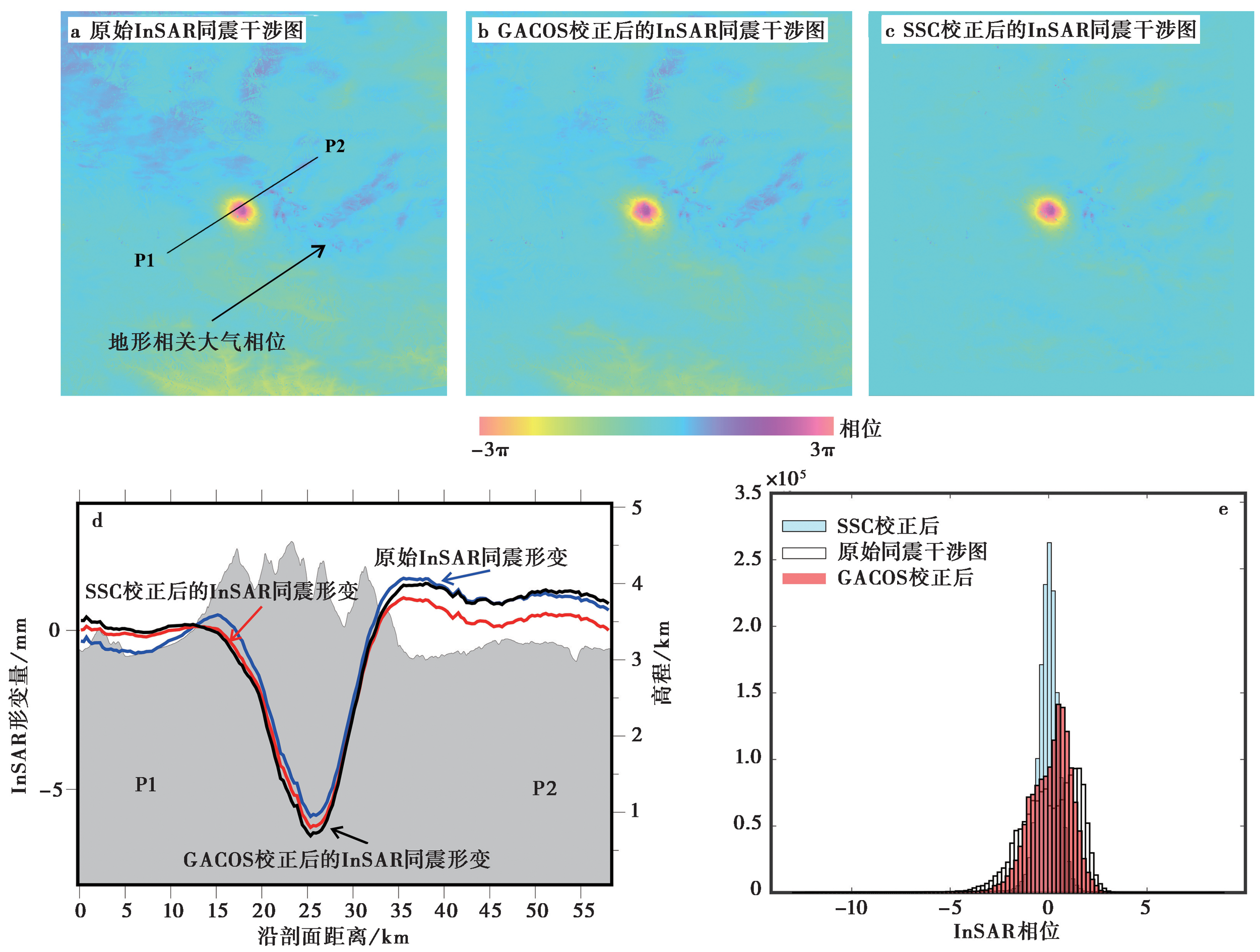
图4 基于不同大气校正方法的同震形变监测应用示例 2016年 MW6.4 门源地震(震源深度10km)的InSAR同震形变监测的例子, 证明采用多窗口经验线性估计方法获取的同震形变场远场地形相关大气相位噪声得到有效抑制。
Fig. 4 Example of the atmospheric phase correction for coseismic deformation field. GACOS: Generic Atmospheric Correction Online Service(Chen et al., 2021); SSC: Simple-Stratification-Correction scheme

图5 2021年青海玛多地震的震前InSAR观测(2015-2020年, C波段Sentinel-1 SAR数据, 修改自Zhao et al., 2022) a 6个相邻轨道的降轨InSAR形变速率场; b 6个相邻轨道的升轨InSAR形变速率场; c 升、降轨InSAR形变速率场解算的EW向形变速率场; 绿色实线为块体边界断裂带; 黑色细线为活动断层; 白色实线为块体边界; 红色实线为历史地震破裂段; 紫色沙滩球为2021年玛多 MW7.3 地震的震源机制解; 蓝色(Wang M et al., 2020)和紫色(Diao et al., 2019)箭头为GPS震间速率场
Fig. 5 InSAR velocity field prior to the 2021 MW7.4 Madoi earthquake (2015-2020, C band Sentinel-1 SAR data, from Zhao et al., 2022).
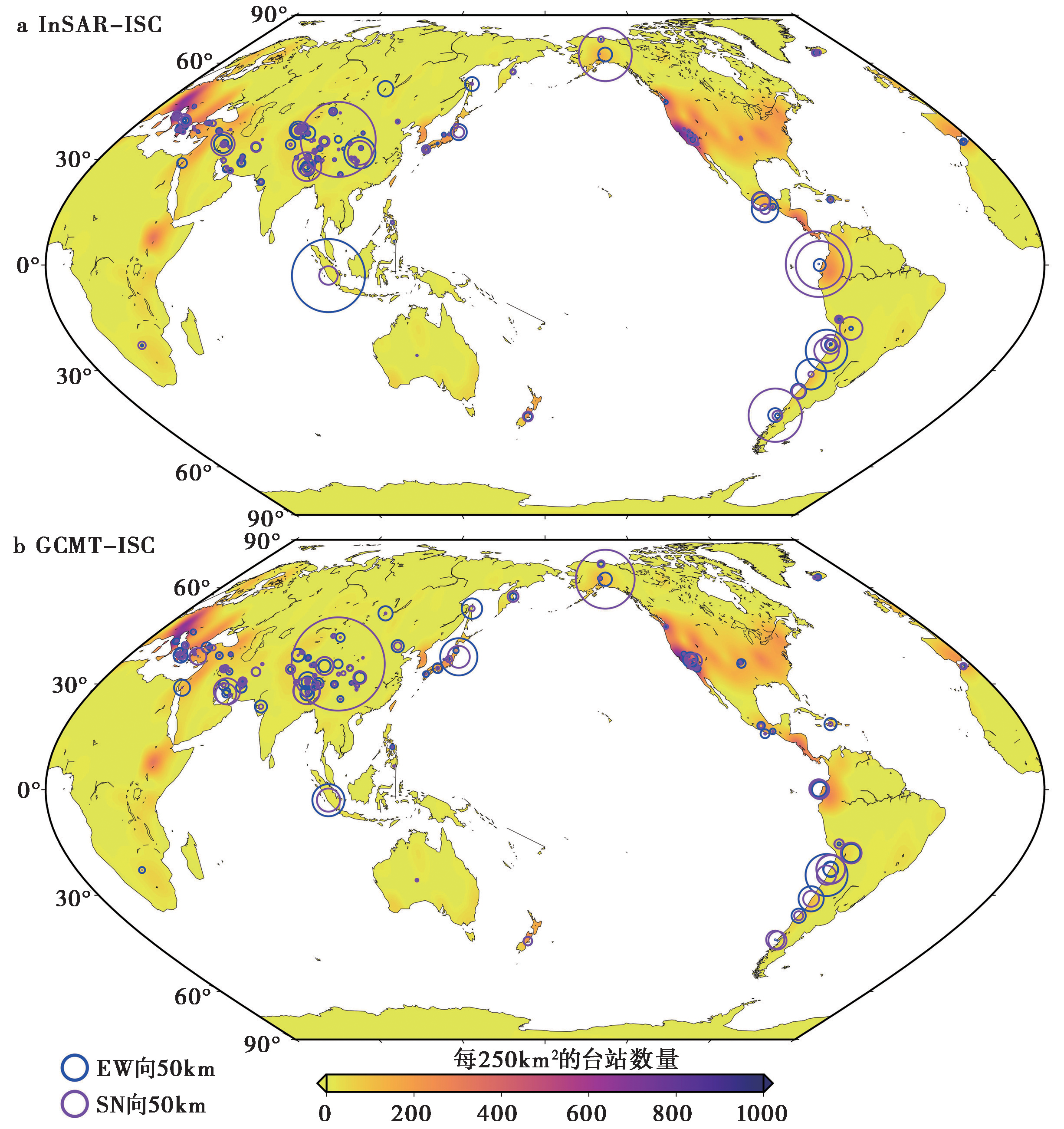
图6 基于InSAR数据获取的矩中心位置和地震学目录(GCMT和ISC)矩中心位置的差异, 底图为区域地震台站的数量(来自Zhu et al., 2021)
Fig. 6 Difference of centroid location between InSAR based observation and seismic data superimposed on the number of seismic stations from Zhu et al.(2021).
| [1] | 季灵运, 刘传金, 徐晶, 等. 2017. 九寨沟 MS7.0 地震的InSAR观测及发震构造分析[J]. 地球物理学报, 60(10): 4069-4082. |
| JI Ling-yun, LIU Chuan-jin, XU Jing, et al. 2017. InSAR observation and inversion of the seismogenic fault for the 2017 Jiuzhaigou MS7.0 earthquake in China[J]. Chinese Journal of Geophysics, 60(10): 4069-4082. (in Chinese) | |
| [2] | 刘传金, 邱江涛, 王金烁. 2018. 基于升降轨 Sentinel-1 SAR 影像研究精河 MS6.6 地震震源机制[J]. 大地测量与地球动力学, 38(11): 1111-1116. |
| LIU Chuan-jin, QIU Jiang-tao, WANG Jin-shuo. 2018. The 2017 Jinghe MS6. 6 earthquake inversion from ascending and descending Sentinel-1 observations[J]. Journal of Geodesy and Geodynamics, 38(11): 1111-1116. (in Chinese) | |
| [3] | 刘云华, 汪驰升, 单新建, 等. 2014. 芦山 MS7.0 地震InSAR形变观测及震源参数反演[J]. 地球物理学报, 57(8): 2495-2506. |
| LIU Yun-hua, WANG Chi-sheng, SHAN Xin-jian, et al. 2014. Result of SAR differential interferometry for the co-seismic deformation and source parameter of the MS7.0 Lushan Earthquake[J]. Chinese Journal of Geophysics, 57(8): 2495-2506. (in Chinese) | |
| [4] | 屈春燕, 左荣虎, 单新建, 等. 2017. 尼泊尔 MW7.8 地震InSAR同震形变场及断层滑动分布[J]. 地球物理学报, 60(1): 151-162. |
| QU Chun-yan, ZUO Rong-hu, SHAN Xin-jian, et al. 2017. Coseismic deformation field of the Nepal MS8.1 earthquake from Sentinel-1A/InSAR data and fault slip inversion[J]. Chinese Journal of Geophysics, 60(1): 151-162. (in Chinese) | |
| [5] | 孙建宝, 石耀霖, 沈正康, 等. 2007. 基于线弹性位错模型反演1997年西藏玛尼 MW7.5 地震的干涉雷达同震形变场--Ⅱ滑动分布反演[J]. 地球物理学报, 50(5): 1390-1397. |
| SUN Jian-bao, SHI Yao-lin, SHEN Zheng-kang, et al. 2007. Parameter inversion of the 1997 Mani earthquake from INSAR co-seismic deformation field based on linear elastic dislocation model: Ⅱ. Slip distribution inversion[J]. Chinese Journal of Geophysics, 50(5): 1390-1397. (in Chinese) | |
| [6] | 万永革, 沈正康, 王敏, 等. 2008. 根据GPS和InSAR数据反演2001年昆仑山口西地震同震破裂分布[J]. 地球物理学报, 51(4): 1074-1084. |
| WAN Yong-ge, SHEN Zheng-kang, WANG Min, et al. 2008. Coseismic slip distribution of the 2001 Kunlun mountain pass west earthquake constrained using GPS and InSAR data[J]. Chinese Journal of Geophysics, 51(4): 1074-1084. (in Chinese) | |
| [7] | 温少妍, 单新建, 张迎峰, 等. 2016. 基于InSAR的青海大柴旦地震三维同震形变场获取与震源特征分析[J]. 地球物理学报, 59(3): 912-921. |
| WEN Shao-yan, SHAN Xin-jian, ZHANG Ying-feng, et al. 2016. Three-dimensional co-seismic deformation of the Da Qaidam, Qinghai earthquakes derived from D-InSAR data and their source features[J]. Chinese Journal of Geophysics, 59(3): 912-921. (in Chinese) | |
| [8] | 张桂芳, 屈春燕, 单新建, 等. 2011. 2010年青海玉树 MS7.1 地震地表破裂带和形变特征分析[J]. 地球物理学报, 54(1): 121-127. |
| ZHANG Gui-fang, QU Chun-yan, SHAN Xin-jian, et al. 2011. The surface rupture and coseismic deformation characteristics of the MS7.1 earthquake at Qinghai Yushu in 2010[J]. Chinese Journal of Geophysics, 54(1): 121-127. (in Chinese) | |
| [9] | 张国宏, 屈春燕, 单新建, 等. 2011. 2008年 MS7.1 于田地震InSAR同震形变场及其震源滑动反演[J]. 地球物理学报, 54(11): 2753-2760. |
| ZHANG Guo-hong, QU Chun-yan, SHAN Xin-jian, et al. 2011. The coseismic InSAR measurements of 2008 Yutian earthquake and its inversion for source parameters[J]. Chinese Journal of Geophysics, 54(11): 2753-2760. (in Chinese) | |
| [10] | 郑文俊, 袁道阳, 张培震, 等. 2016. 青藏高原东北缘活动构造几何图像、运动转换与高原扩展[J]. 第四纪研究, 36(4): 775-788. |
| ZHENG Wen-jun, YUAN Dao-yang, ZHANG Pei-zhen, et al. 2016. Tectonic geometry and kinematic dissipation of the active faults in the northeastern Tibetan plateau and their implications for understanding northeastward growth of the plateau[J]. Quaternary Sciences, 36(4): 775-788. (in Chinese) | |
| [11] |
Barbot S, Agram P, De Michele M. 2013. Change of apparent segmentation of the San Andreas fault around Parkfield from space geodetic observations across multiple periods[J]. Journal of Geophysical Research: Solid Earth, 118(12): 6311-6327.
DOI URL |
| [12] |
Bürgmann R. 2018. The geophysics, geology and mechanics of slow fault slip[J]. Earth and Planetary Science Letters, 495(2018): 112-134.
DOI URL |
| [13] |
Bürgmann R, Dresen G. 2008. Rheology of the lower crust and upper mantle: Evidence from rock mechanics, geodesy, and field observations[J]. Annual Review of Earth and Planetary Sciences, 36(1): 531-567.
DOI URL |
| [14] | Cavalié O, Lasserre C, Doin M P, et al. 2008. Measurement of interseismic strain across the Haiyuan fault(Gansu, China), by InSAR[J]. Earth and Planetary Science Letters, 275(3-4): 246-257. |
| [15] | Chen Y U, Li Z, Bai L, et al. 2021. Successful applications of generic atmospheric correction online service for InSAR(GACOS)to the reduction of atmospheric effects on InSAR observations[J]. Journal of Geodesy and Geoinformation Science, 4(1): 109-115. |
| [16] |
Daout S, Sudhaus H, Kausch T, et al. 2019. Interseismic and postseismic shallow creep of the North Qaidam Thrust faults detected with a multitemporal InSAR analysis[J]. Journal of Geophysical Research: Solid Earth, 124(7): 7259-7279.
DOI URL |
| [17] | Dawson J, Tregoning P. 2007. Uncertainty analysis of earthquake source parameters determined from InSAR: A simulation study[J]. Journal of Geophysical Research: Solid Earth, 112(B9): B09406. |
| [18] | Devlin S, Isacks B L, Pritchard M E, et al. 2012. Depths and focal mechanisms of crustal earthquakes in the central Andes determined from teleseismic waveform analysis and InSAR[J]. Tectonics, 31(2): TC2002. |
| [19] |
Diao F, Xiong X, Wang R, et al. 2019. Slip rate variation along the Kunlun fault(Tibet): Results from new GPS observations and a viscoelastic earthquake-cycle deformation model[J]. Geophysical Research Letters, 46(5): 2524-2533.
DOI URL |
| [20] | Elliott J R, Biggs J, Parsons B, et al. 2008. InSAR slip rate determination on the Altyn Tagh Fault, northern Tibet, in the presence of topographically correlated atmospheric delays[J]. Geophysical Research Letters, 35(12): L12309. |
| [21] |
Elliott J R, Jolivet R, González P J, et al. 2016. Himalayan megathrust geometry and relation to topography revealed by the Gorkha earthquake[J]. Nature Geoscience, 9(2): 174-180.
DOI |
| [22] | Elliott J R, Parsons B, Jackson J A, et al. 2011. Depth segmentation of the seismogenic continental crust: The 2008 and 2009 Qaidam earthquakes[J]. Geophysical Research Letters, 38(6): L06305. |
| [23] | Feng G C, Hetland E A, Ding X L, et al. 2010. Coseismic fault slip of the 2008 MW7.9 Wenchuan earthquake estimated from InSAR and GPS measurements[J]. Geophysical Research Letters, 37(1): L01302. |
| [24] |
Feng G C, Li Z W, Shan X J, et al. 2015. Geodetic model of the 2015 April 25 MW7.8 Gorkha Nepal Earthquake and MW7.3 aftershock estimated from InSAR and GPS data[J]. Geophysical Journal International, 203(2): 896-900.
DOI URL |
| [25] |
Fialko Y, Sandwell D, Simons M, et al. 2005. Three-dimensional deformation caused by the Bam, Iran, earthquake and the origin of shallow slip deficit[J]. Nature, 435(7040): 295-299.
DOI |
| [26] | Funning G J, Parsons B, Wright T J, et al. 2005. Surface displacements and source parameters of the 2003 Bam(Iran)earthquake from Envisat advanced synthetic aperture radar imagery[J]. Journal of Geophysical Research: Solid Earth, 110(B9): B09406. |
| [27] |
Garthwaite M C, Wang H, Wright T J. 2013. Broadscale interseismic deformation and fault slip rates in the central Tibetan plateau observed using InSAR[J]. Journal of Geophysical Research: Solid Earth, 118(9): 5071-5083.
DOI URL |
| [28] |
Gong W Y, Zhang Y F, Li T, et al. 2019. Multi-sensor geodetic observations and modeling of the 2017 MW6.3 Jinghe earthquake[J]. Remote Sensing, 11(18): 2157.
DOI URL |
| [29] |
Grandin R, Doin M P, Bollinger L, et al. 2012. Long-term growth of the Himalaya inferred from interseismic InSAR measurement[J]. Geology, 40(12): 1059-1062.
DOI URL |
| [30] |
Grandin R, Klein E, Métois M, et al. 2016. Three-dimensional displacement field of the 2015 MW8.3 Illapel earthquake(Chile)from across- and along-track Sentinel-1 TOPS interferometry[J]. Geophysical Research Letters, 43(6): 2552-2561.
DOI URL |
| [31] |
Guo R, Yang H, Li Y, et al. 2021. Complex slip distribution of the 2021 MW7.4 Maduo, China, earthquake: An event occurring on the slowly slipping fault[J]. Seismological Research Letters, 93(2A): 653-665.
DOI URL |
| [32] |
Hamling I J, Hreinsdóttir S, Clark K, et al. 2017. Complex multifault rupture during the 2016 MW7.8 Kaikōura earthquake, New Zealand[J]. Science, 356(6334): eaam7194.
DOI URL |
| [33] |
Hao K X, Si H, Fujiwara H, et al. 2009. Coseismic surface-ruptures and crustal deformations of the 2008 Wenchuan earthquake MW7.9, China[J]. Geophysical Research Letters, 36(11): L11303.
DOI URL |
| [34] | He L J, Feng G C, Wu X X, et al. 2021. Coseismic and early postseismic slip models of the 2021 MW7.4 Maduo earthquake(western China)estimated by space-based geodetic data[J]. Geophysical Research Letters, 48(24): e2021GL095860. |
| [35] |
He P, Ding K, Xu C. 2018. The 2016 MW6.7 Aketao earthquake in Muji range, northern Pamir: Rupture on a strike-slip fault constrained by Sentinel-1 radar interferometry and GPS[J]. International Journal of Applied Earth Observation and Geoinformation, 73: 99-106.
DOI URL |
| [36] | Hooper A, Zebker H, Segall P, et al. 2004. A new method for measuring deformation on volcanoes and other natural terrains using InSAR persistent scatterers[J]. Geophysical Research Letters, 31(23): L23611. |
| [37] |
Hu J, Li Z W, Ding X L, et al. 2014. Resolving three-dimensional surface displacements from InSAR measurements: A review[J]. Earth-Science Reviews, 133: 1-17.
DOI URL |
| [38] | Huang M H, Huang H H. 2018. The complexity of the 2018 MW6.4 Hualien earthquake in east Taiwan[J]. Geophysical Research Letters, 45(24): 13249-13257. |
| [39] | Jin Z, Fialko Y. 2021. Coseismic and early postseismic deformation due to the 2021 M7.4 Maduo(China)earthquake[J]. Geophysical Research Letters, 48(21): e2021GL095213. |
| [40] | Jolivet R, Lasserre C, Doin M P, et al. 2013. Spatio-temporal evolution of aseismic slip along the Haiyuan fault, China: Implications for fault frictional properties[J]. Earth and Planetary Science Letters, 377-378: 23-33. |
| [41] | Lasserre C, Peltzer G, Crampé F, et al. 2005. Coseismic deformation of the 2001 MW=7.8 Kokoxili earthquake in Tibet, measured by synthetic aperture radar interferometry[J]. Journal of Geophysical Research: Solid Earth, 110(B12): B12408. |
| [42] |
Lee S J, Lin T C, Liu T Y, et al. 2019. Fault-to-fault jumping rupture of the 2018 MW6.4 Hualien earthquake in eastern Taiwan[J]. Seismological Research Letters, 90(1): 30-39.
DOI URL |
| [43] | Li X, Jónsson S, Cao Y. 2021. Interseismic deformation from Sentinel-1 burst-overlap interferometry: Application to the Southern Dead Sea Fault[J]. Geophysical Research Letters, 48(16): e2021GL093481. |
| [44] |
Li Y, Bürgmann R, Zhao B. 2020. Evidence of fault immaturity from shallow slip deficit and lack of postseismic deformation of the 2017 MW6.5 Jiuzhaigou earthquake[J]. Bulletin of the Seismological Society of America, 110(1): 154-165.
DOI URL |
| [45] |
Liu C, Ji L, Zhu L, et al. 2018. InSAR-constrained interseismic deformation and potential seismogenic asperities on the Altyn Tagh fault at 91.5°-95°E, northern Tibetan plateau[J]. Remote Sensing, 10(6): 943.
DOI URL |
| [46] | Liu F, Elliott J R, Craig T J, et al. 2021. Improving the resolving power of InSAR for earthquakes using time series: a case study in Iran[J]. Geophysical Research Letters, 48(14): e2021GL093043. |
| [47] |
Liu G, Xiong W, Wang Q, et al. 2019. Source characteristics of the 2017 MS7.0 Jiuzhaigou, China, earthquake and implications for recent seismicity in eastern Tibet[J]. Journal of Geophysical Research: Solid Earth, 124(5): 4895-4915.
DOI URL |
| [48] |
Lo Y C, Yue H, Sun J, et al. 2019. The 2018 MW6. 4 Hualien earthquake: dynamic slip partitioning reveals the spatial transition from mountain building to subduction[J]. Earth and Planetary Science Letters, 524: 115729.
DOI URL |
| [49] |
Luo H, Wang T, Wei S, et al. 2021. Deriving centimeter-level coseismic deformation and fault geometries of small-to-moderate earthquakes from time-series Sentinel-1 SAR images[J]. Frontiers in Earth Science, 9: 636398.
DOI URL |
| [50] | Materna K, Wei S, Wang X, et al. 2019. Source characteristics of the 2017 MW6.4 Moijabana, Botswana earthquake, a rare lower-crustal event within an ancient zone of weakness[J]. Earth and Planetary Science Letters, 56: 348-359. |
| [51] | Mellors R J, Magistrale H, Earle P, et al. 2004. Comparison of four moderate-size earthquakes in southern California using seismology and InSAR[J]. Bulletin of the Seismological Society of America, 94(6): 2004-2014. |
| [52] |
Mencin D, Bendick R, Upreti B N, et al. 2016. Himalayan strain reservoir inferred from limited afterslip following the Gorkha earthquake[J]. Nature Geoscience, 9(7): 533-537.
DOI |
| [53] |
Mueller C S. 2019. Earthquake catalogs for the USGS national seismic hazard maps[J]. Seismological Research Letters, 90(1): 251-261.
DOI |
| [54] |
Qian Y, Chen X, Luo H, et al. 2019. An extremely shallow MW4.1 thrust earthquake in the eastern Sichuan Basin(China)likely triggered by unloading during infrastructure construction[J]. Geophysical Research Letters, 46(23): 13775-13784.
DOI URL |
| [55] |
Qu C Y, Zhang G H, Shan X J, et al. 2013. Coseismic deformation derived from analyses of C and L band SAR data and fault slip inversion of the Yushu MS7.1 earthquake, China in 2010[J]. Tectonophysics, 584: 119-128.
DOI URL |
| [56] |
Ryder I, Bürgmann R, Pollitz F. 2011. Lower crustal relaxation beneath the Tibetan plateau and Qaidam Basin following the 2001 Kokoxili earthquake[J]. Geophysical Journal International, 187(2): 613-630.
DOI URL |
| [57] | Shan X, Ma J, Wang C, et al. 2004. Co-seismic ground deformation and source parameters of Mani M7.9 earthquake inferred from spaceborne D-InSAR observation data[J]. Science in China(Ser D), 47(6): 481-488. |
| [58] |
Shan X, Zhang G, Wang C, et al. 2011. Source characteristics of the Yutian earthquake in 2008 from inversion of the co-seismic deformation field mapped by InSAR[J]. Journal of Asian Earth Sciences, 40(4): 935-942.
DOI URL |
| [59] |
Shen Z K, Sun J, Zhang P, et al. 2009. Slip maxima at fault junctions and rupturing of barriers during the 2008 Wenchuan earthquake[J]. Nature Geoscience, 2(10): 718-724.
DOI |
| [60] | Sun J, Johnson K M, Cao Z, et al. 2011. Mechanical constraints on inversion of coseismic geodetic data for fault slip and geometry: Example from InSAR observation of the 6 October 2008 MW6.3 Dangxiong-Yangyi(Tibet)earthquake[J]. Journal of Geophysical Research: Solid Earth, 116(B1): B01406. |
| [61] |
Sun J, Yue H, Shen Z, et al. 2018. The 2017 Jiuzhaigou earthquake: A complicated event occurred in a young fault system[J]. Geophysical Research Letters, 45(5): 2230-2240.
DOI URL |
| [62] |
Tao W, Shen Z K, Wan Y G, et al. 2007. Crustal elasticity contrast across the East Kunlun fault in northern Tibet inferred from InSAR measurements of the 2001 MW7.8 Kokoxili earthquake[J]. Chinese Journal of Geophysics, 50(3): 658-665.
DOI URL |
| [63] | Talebian M, Fielding E J, Funning G J, et al. 2004. The 2003 Bam(Iran)earthquake: Rupture of a blind strike-slip fault[J]. Geophysical research letters, 31(11): L11611. |
| [64] |
Tong X, Sandwell D T, Smith-Konter B. 2013. High-resolution interseismic velocity data along the San Andreas Fault from GPS and InSAR[J]. Journal of Geophysical Research: Solid Earth, 118(1): 369-389.
DOI URL |
| [65] | Vallage A, Klinger Y, Grandin R, et al. 2015. Inelastic surface deformation during the 2013 MW7.7 Balochistan, Pakistan, earthquake[J]. Geology, 43(12): 1079-1082. |
| [66] | Wang H, Wright T J, Biggs J. 2009. Interseismic slip rate of the northwestern Xianshuihe fault from InSAR data[J]. Geophysical Research Letters, 36(3): L03302. |
| [67] |
Wang H, Wright T J, Liu-Zeng J, et al. 2019. Strain rate distribution in south-central Tibet from two decades of InSAR and GPS[J]. Geophysical Research Letters, 46(10): 5170-5179.
DOI |
| [68] |
Wang K, Dreger D S, Tinti E, et al. 2020. Rupture process of the 2019 Ridgecrest, California MW6.4 foreshock and MW7.1 earthquake constrained by seismic and geodetic data[J]. Bulletin of the Seismological Society of America, 110(4): 1603-1626.
DOI URL |
| [69] |
Wang K, Fialko Y. 2015. Slip model of the 2015 MW7.8 Gorkha(Nepal)earthquake from inversions of ALOS-2 and GPS data[J]. Geophysical Research Letters, 42(18): 7452-7458.
DOI URL |
| [70] | Wang M, Shen Z K. 2020. Present-day crustal deformation of continental China derived from GPS and its tectonic implications[J]. Journal of Geophysical Research: Solid Earth, 125(2): e2019JB018774. |
| [71] |
Wang Q, Qiao X J, Lan Q G, et al. 2011. Rupture of deep faults in the 2008 Wenchuan earthquake and uplift of the Longmen Shan[J]. Nature Geoscience, 4(9): 634-640.
DOI |
| [72] |
Wang S, Xu C, Wen Y, et al. 2017. Slip model for the 25 November 2016 MW6.6 Aketao earthquake, western China, revealed by Sentinel-1 and ALOS-2 observations[J]. Remote Sensing, 9(4): 325.
DOI URL |
| [73] |
Wang X, Liu G, Yu B, et al. 2014. 3D coseismic deformations and source parameters of the 2010 Yushu earthquake(China)inferred from DInSAR and multiple-aperture InSAR measurements[J]. Remote sensing of environment, 152: 174-189.
DOI URL |
| [74] |
Wei S, Fielding E, Leprince S, et al. 2011. Superficial simplicity of the 2010 El Mayor-Cucapah earthquake of Baja California in Mexico[J]. Nature Geoscience, 4(9): 615-618.
DOI |
| [75] |
Wimpenny S, Copley A, Ingleby T. 2017. Fault mechanics and post-seismic deformation at Bam, SE Iran[J]. Geophysical Journal International, 209(2): 1018-1035.
DOI URL |
| [76] |
Wimpenny S, Watson C S. 2021. gWFM: A global catalog of moderate-magnitude earthquakes studied using teleseismic body waves[J]. Seismological Research Letters, 92(1): 212-226.
DOI URL |
| [77] | Wright T J, Parsons B E, Lu Z. 2004. Toward mapping surface deformation in three dimensions using InSAR[J]. Geophysical Research Letters, 31(1): L01607. |
| [78] |
Xu C, Liu Y, Wen Y, et al. 2010. Coseismic slip distribution of the 2008 MW7.9 Wenchuan earthquake from joint inversion of GPS and InSAR data[J]. Bulletin of the Seismological Society of America, 100(5B): 2736-2749.
DOI URL |
| [79] | Yu C, Penna N T, Li Z. 2017. Generation of real-time mode high-resolution water vapor fields from GPS observations[J]. Journal of Geophysical Research: Atmospheres, 122(3): 2008-2025. |
| [80] |
Zhang G H, Qu C Y, Shan X J, et al. 2011. Slip distribution of the 2008 Wenchuan MS7.9 earthquake by joint inversion from GPS and InSAR measurements: a resolution test study[J]. Geophysical Journal International, 186(1): 207-220.
DOI URL |
| [81] |
Zhang G H, Shan X J, Delouis B, et al. 2013. Rupture history of the 2010 MS7.1 Yushu earthquake by joint inversion of teleseismic data and InSAR measurements[J]. Tectonophysics, 584: 129-137.
DOI URL |
| [82] |
Zhang Y, Shan X, Gong W, et al. 2021. The ambiguous fault geometry derived from InSAR measurements of buried thrust earthquakes: a synthetic data based study[J]. Geophysical Journal International, 225(3): 1799-1811.
DOI URL |
| [83] | Zhao D, Qu C, Bürgmann R, et al. 2022. Large-scale crustal deformation, slip-rate variation, and strain distribution along the Kunlun Fault(Tibet)from Sentinel-1 InSAR observations(2015-2020)[J]. Journal of Geophysical Research: Solid Earth, 127(1): e2021JB022892. |
| [84] | Zhao D, Qu C, Chen H, et al. 2021. Tectonic and geometric control on fault kinematics of the 2021 MW7.3 Maduo(China)earthquake inferred from interseismic, coseismic, and postseismic InSAR observations[J]. Geophysical Research Letters, 48(18): e2021GL095417. |
| [85] |
Zhao D, Qu C, Shan X, et al. 2018. InSAR and GPS derived coseismic deformation and fault model of the 2017 MS7.0 Jiuzhaigou earthquake in the Northeast Bayanhar block[J]. Tectonophysics, 726: 86-99.
DOI URL |
| [86] |
Zhu C, Wang C, Zhang B, et al. 2021. Differential Interferometric Synthetic Aperture Radar data for more accurate earthquake catalogs[J]. Remote Sensing of Environment, 266: 112690.
DOI URL |
| [87] |
Zuo R, Qu C, Shan X J, et al. 2016. Coseismic deformation fields and a fault slip model for the MW7.8 mainshock and MW7.3 aftershock of the Gorkha-Nepal 2015 earthquake derived from Sentine-1A SAR interferometry[J]. Tectonophysics, 686: 158-169.
DOI URL |
| [1] | 刘白云, 赵莉, 刘云云, 王文才, 张卫东. 2021年5月22日青海玛多M7.4地震余震重新定位与断层面参数拟合[J]. 地震地质, 2023, 45(2): 500-516. |
| [2] | 张珂, 王鑫, 杨红樱, 王玥, 徐岩, 李静. 2021年云南漾濞MS6.4地震序列特征及其发震构造分析[J]. 地震地质, 2023, 45(1): 231-251. |
| [3] | 李传友, 孙凯, 马骏, 李俊杰, 梁明剑, 房立华. 四川泸定6.8级地震--鲜水河断裂带磨西段局部发起、 全段参与的一次复杂事件[J]. 地震地质, 2022, 44(6): 1648-1666. |
| [4] | 张博譞, 郑文俊, 陈杰, 何骁慧, 李启雷, 张冬丽, 段磊, 陈干. 柴达木盆地北部2021年6月16日青海茫崖MS5.8地震发震构造分析[J]. 地震地质, 2022, 44(5): 1313-1332. |
| [5] | 姚生海, 盖海龙, 殷翔, 刘炜, 张加庆, 袁建新. 阿木尼克山山前地表破裂带与1962年6.8级地震关系的讨论[J]. 地震地质, 2022, 44(4): 976-991. |
| [6] | 梁宽, 何仲太, 姜文亮, 李永生, 刘泽民. 2022年1月8日青海门源MS6.9地震的同震地表破裂特征[J]. 地震地质, 2022, 44(1): 256-278. |
| [7] | 高帆, 韩竹军, 袁仁茂, 董绍鹏, 郭鹏. 滇东南地区小江断裂南段历史滑坡特征及其地震地质意义[J]. 地震地质, 2021, 43(6): 1412-1434. |
| [8] | 姚生海, 盖海龙, 殷翔, 李鑫. 青海玛多MS7.4地震地表破裂带的基本特征和典型现象[J]. 地震地质, 2021, 43(5): 1060-1072. |
| [9] | 贾蕊, 张国宏, 解朝娣, 单新建, 张迎峰, 李成龙, 黄自成. 2019年巴基斯坦新米尔普尔MW6.0地震的同震形变场与断层滑动分布反演[J]. 地震地质, 2021, 43(3): 600-613. |
| [10] | 赵启光, 孙业君, 黄耘, 杨伟林, 顾勤平, 孟科, 杨浩. 高邮-宝应MS4.9地震的发震构造[J]. 地震地质, 2021, 43(3): 630-646. |
| [11] | 李传友, 张金玉, 王伟, 孙凯, 单新建. 2021年云南漾濞6.4级地震发震构造分析[J]. 地震地质, 2021, 43(3): 706-721. |
| [12] | 崔仁胜, 赵翠萍, 周连庆, 陈阳. 2020年1月19日新疆伽师MS6.4地震序列的活动特征和发震构造[J]. 地震地质, 2021, 43(2): 329-344. |
| [13] | 李启雷, 李玉丽, 屠泓为, 刘文邦. 丁青地区地震重定位、 震源机制及其发震构造初步分析[J]. 地震地质, 2021, 43(1): 209-231. |
| [14] | 刘白云, 尹志文, 袁道阳, 李亮, 王维欢. 青藏高原东北缘老虎山断裂的断层面参数拟合及其几何意义[J]. 地震地质, 2020, 42(6): 1354-1369. |
| [15] | 董丽娜, 连尉平, 陈为涛, 马海建. 防震减灾公共服务现状与需求全国公众调查结果分析[J]. 地震地质, 2020, 42(3): 762-771. |
| 阅读次数 | ||||||
|
全文 |
|
|||||
|
摘要 |
|
|||||
