地震地质 ›› 2025, Vol. 47 ›› Issue (2): 429-447.DOI: 10.3969/j.issn.0253-4967.2025.02.20240142
陈子龙1)( ), 刘刚1,2),*(), 李琦1), 陈威1), 赵昕宇3), 林牧1,4), 陶隆文1), 乔学军1,2), 聂兆生1,2)
收稿日期:2024-11-27
修回日期:2025-01-16
出版日期:2025-04-20
发布日期:2025-06-07
通讯作者:
* 刘刚, 男, 1984年生, 研究员, 主要研究方向为地震大地测量, E-mail: whgpslg@cgps.ac.cn。
作者简介:陈子龙, 男, 2000年生, 现为中国地震局地震研究所大地测量学与测量工程专业在读硕士研究生, 主要研究方向为地震大地测量学, E-mail: 13147197065@163.com。
基金资助:
CHEN Zi-long1)(), LIU Gang1,2),*(), LI Qi1), CHEN Wei1), ZHAO Xin-yu3), LIN Mu1,4), TAO Long-wen1), QIAO Xue-jun1,2), NIE Zhao-sheng1,2)
Received:2024-11-27
Revised:2025-01-16
Online:2025-04-20
Published:2025-06-07
摘要:
文中利用Sentinel-1升、 降轨影像获取2024年乌什 MW7.0 地震的视线向同震形变场, 并约束发震断层几何参数和滑动分布。最佳断层模型为沿走向弯折的双断层结构, 弯折前后走向变化约为25°, 倾角约有20°的差异。断层滑动为高倾角逆冲兼左旋走滑, 主要分布于震中及其西侧, 东侧幅度低且相对弥散, 整体分布具有浅部滑移亏损特征。几何差异和滑动分布的空间相关性表明发震构造在震中以东存在几何复杂体, 以障碍体模式阻碍破裂传播。同震扩展围限于玉山古溪和乌什凹陷之间, 东、 西两侧的断裂阶区和复杂构造限定了破裂规模。MW5.7余震形成了清晰的LOS向变形, 最优模型显示其发震断层偏离主震迹线约10°, 倾向SE, 断层面地表迹线与地表破裂几乎重合, 浅层滑动量与调查所得的错断量相当。
陈子龙, 刘刚, 李琦, 陈威, 赵昕宇, 林牧, 陶隆文, 乔学军, 聂兆生. 2024年乌什MW7.0地震InSAR同震形变与发震构造[J]. 地震地质, 2025, 47(2): 429-447.
CHEN Zi-long, LIU Gang, LI Qi, CHEN Wei, ZHAO Xin-yu, LIN Mu, TAO Long-wen, QIAO Xue-jun, NIE Zhao-sheng. INSAR COSEISMIC DEFORMATION AND SEISMOGENIC STRUCTURE OF THE 2024 MW7.0 WUSHI EARTHQUAKE[J]. SEISMOLOGY AND GEOLOGY, 2025, 47(2): 429-447.
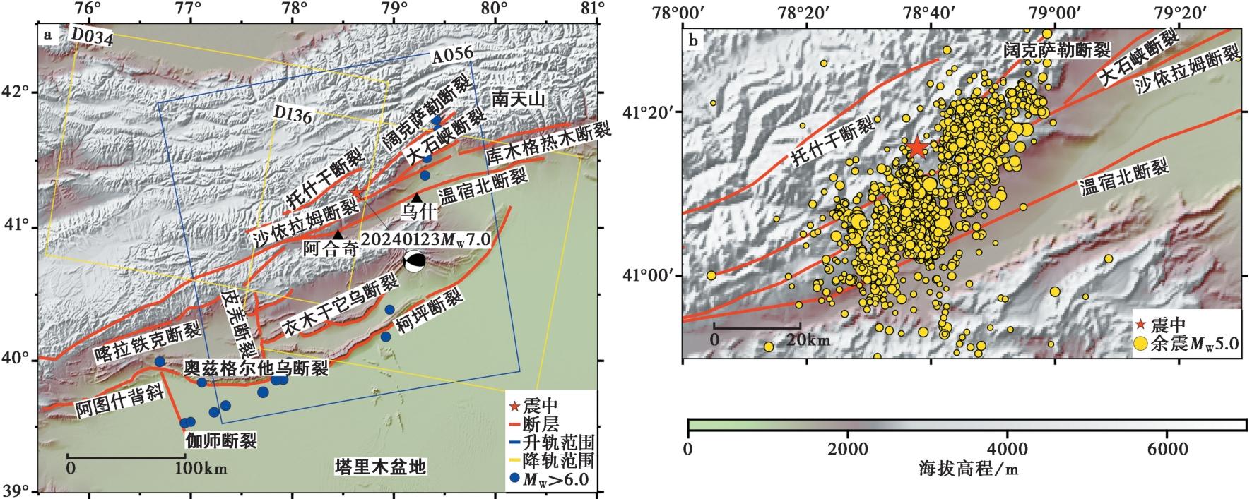
图 1 地震构造背景图 a 影像数据覆盖范围及该区域1950年以来6级以上历史地震分布; b 震后60d内的不同震级的余震分布。历史地震信息及震源机制解来自USGS; 断裂分布信息来自中国地震局地质研究所
Fig. 1 Tectonic background.
| 来源 | 震中位置 | 走向/(°) | 倾角/(°) | 滑动角/(°) | 震级/MW | |
|---|---|---|---|---|---|---|
| USGS | 78.64°E,41.26°N | 235 | 45 | 42 | 7.0 | |
| 113 | 62 | 126 | ||||
| GCMT | 78.57°E,41.19°N | 236 | 48 | 47 | 7.0 | |
| 110 | 57 | 127 | ||||
| CENC | 78.63°E,41.26°N | 233 | 49 | 41 | 7.1 | |
| 131 | 60 | 131 | ||||
| 李雨森等, | 78.63°E,41.26°N | 229 | 62.4 | 50.45 | 7.0 | |
| 赵磊等, | 78.60°E,41.19°N | 228 | 67 | 60 | 7.0 | |
| 黄旺等, | 78.60°E,41.23°N | 230 | 48 | 48 | 7.0 | |
| 能懿菡等, | 78.64°E,41.23°N | 230 | 57 | 41 | 7.1 | |
| 柳姣姣等, | 78.63°E,41.26°N | 230 | 67 | 45 | 7.0 | |
| 本研究最优单断层模型F1 | 78.63°E,41.24°N | 225 | 56 | 51 | 7.1 | |
| 本研究双断层模型 | F1 | 225 | 60 | 41 | 7.01 | |
| F2 | 250 | 40 | 56 | |||
表 1 不同机构和研究公布的发震断层参数
Table1 Fault parameters published by different organizations and studies
| 来源 | 震中位置 | 走向/(°) | 倾角/(°) | 滑动角/(°) | 震级/MW | |
|---|---|---|---|---|---|---|
| USGS | 78.64°E,41.26°N | 235 | 45 | 42 | 7.0 | |
| 113 | 62 | 126 | ||||
| GCMT | 78.57°E,41.19°N | 236 | 48 | 47 | 7.0 | |
| 110 | 57 | 127 | ||||
| CENC | 78.63°E,41.26°N | 233 | 49 | 41 | 7.1 | |
| 131 | 60 | 131 | ||||
| 李雨森等, | 78.63°E,41.26°N | 229 | 62.4 | 50.45 | 7.0 | |
| 赵磊等, | 78.60°E,41.19°N | 228 | 67 | 60 | 7.0 | |
| 黄旺等, | 78.60°E,41.23°N | 230 | 48 | 48 | 7.0 | |
| 能懿菡等, | 78.64°E,41.23°N | 230 | 57 | 41 | 7.1 | |
| 柳姣姣等, | 78.63°E,41.26°N | 230 | 67 | 45 | 7.0 | |
| 本研究最优单断层模型F1 | 78.63°E,41.24°N | 225 | 56 | 51 | 7.1 | |
| 本研究双断层模型 | F1 | 225 | 60 | 41 | 7.01 | |
| F2 | 250 | 40 | 56 | |||
| 卫星轨道 | 轨道号 | 主影像时间 | 辅影像时间 | 极化方式 | 干涉模式 | 时间基线/d |
|---|---|---|---|---|---|---|
| 升轨 | T056 | 2024-01-14 | 2024-01-26 | VV | IW | 12 |
| 降轨 | T136 | 2024-01-20 | 2024-02-25 | VV | IW | 36 |
| 降轨 | T034 | 2024-01-13 | 2024-01-25 | VV | IW | 12 |
表2 本文采用的Sentinel-1卫星数据
Table2 Sentinel-1 satellite data used in this study
| 卫星轨道 | 轨道号 | 主影像时间 | 辅影像时间 | 极化方式 | 干涉模式 | 时间基线/d |
|---|---|---|---|---|---|---|
| 升轨 | T056 | 2024-01-14 | 2024-01-26 | VV | IW | 12 |
| 降轨 | T136 | 2024-01-20 | 2024-02-25 | VV | IW | 36 |
| 降轨 | T034 | 2024-01-13 | 2024-01-25 | VV | IW | 12 |
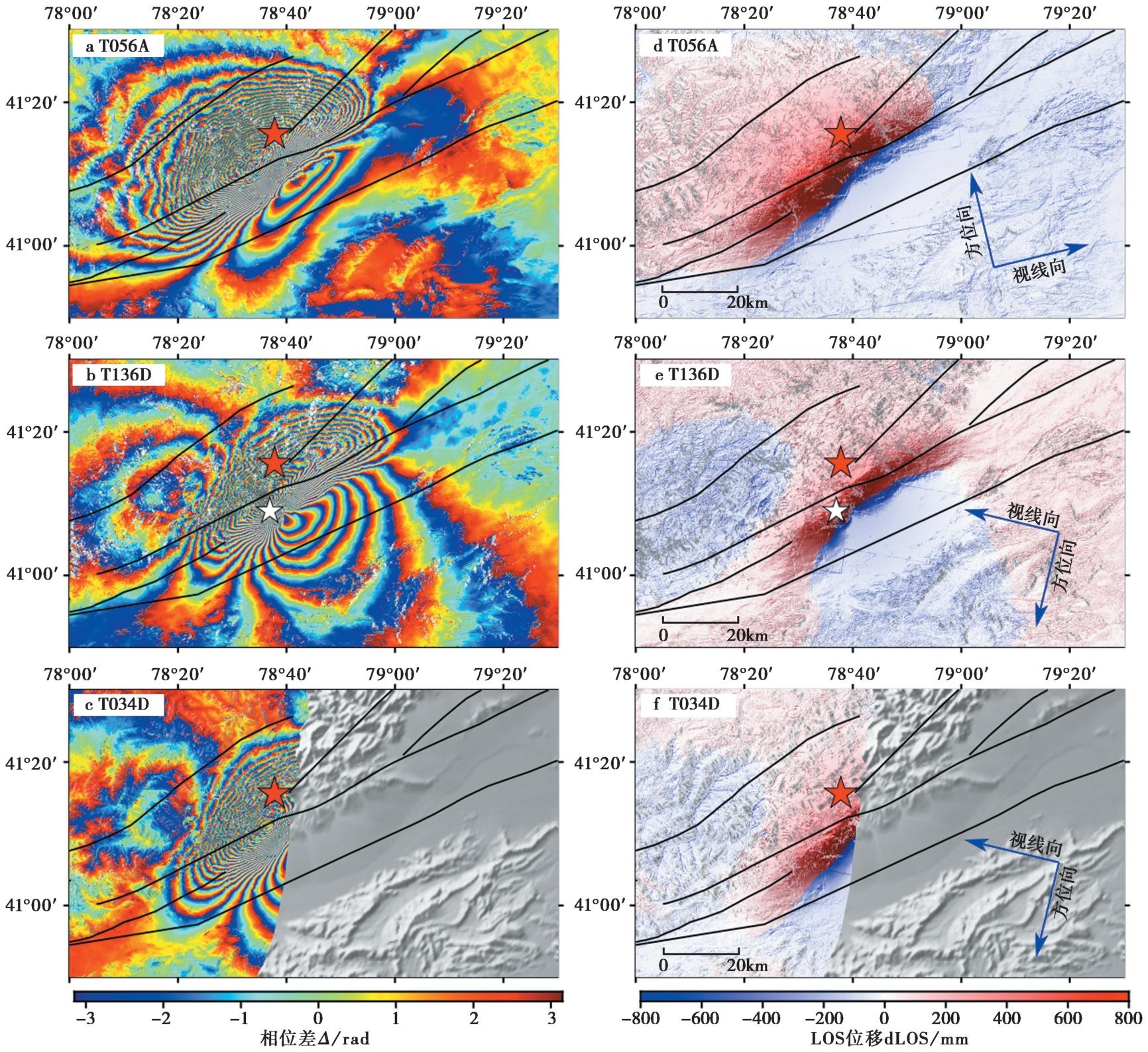
图 2 升、 降轨差分干涉条纹图和同震形变场 a T56差分干涉条纹图; b T136差分干涉条纹图; c T34差分干涉条纹图; d T56升轨同震形变场; e T136降轨同震形变场; f T34降轨同震形变场。 红色五角星表示CENC震中, 白色五角星表示北京时间2024年1月30日 MW5.7 余震的位置
Fig. 2 Ascending and descending differential interferograms and coseismic deformation field.
| 模型 | 走向/(°) | 倾角/(°) | 滑动角/(°) | 长度/km | 宽度/km | 滑动量/m |
|---|---|---|---|---|---|---|
| 单断层模型F1段 | [180,270] | [5,85] | [10,80] | [20,100] | [5,25] | [0.1,5.0] |
| 双断层模型F1段 | [180,270] | [5,85] | [10,80] | [20,30] | [10,20] | [0.1,5.0] |
| 双断层模型F2段 | [180,270] | [5,85] | [10,80] | [10,20] | [10,20] | [0.1,5.0] |
表3 单断层和双断层模型参数设置范围
Table3 Parameter ranges for single-fault and dual-fault models
| 模型 | 走向/(°) | 倾角/(°) | 滑动角/(°) | 长度/km | 宽度/km | 滑动量/m |
|---|---|---|---|---|---|---|
| 单断层模型F1段 | [180,270] | [5,85] | [10,80] | [20,100] | [5,25] | [0.1,5.0] |
| 双断层模型F1段 | [180,270] | [5,85] | [10,80] | [20,30] | [10,20] | [0.1,5.0] |
| 双断层模型F2段 | [180,270] | [5,85] | [10,80] | [10,20] | [10,20] | [0.1,5.0] |
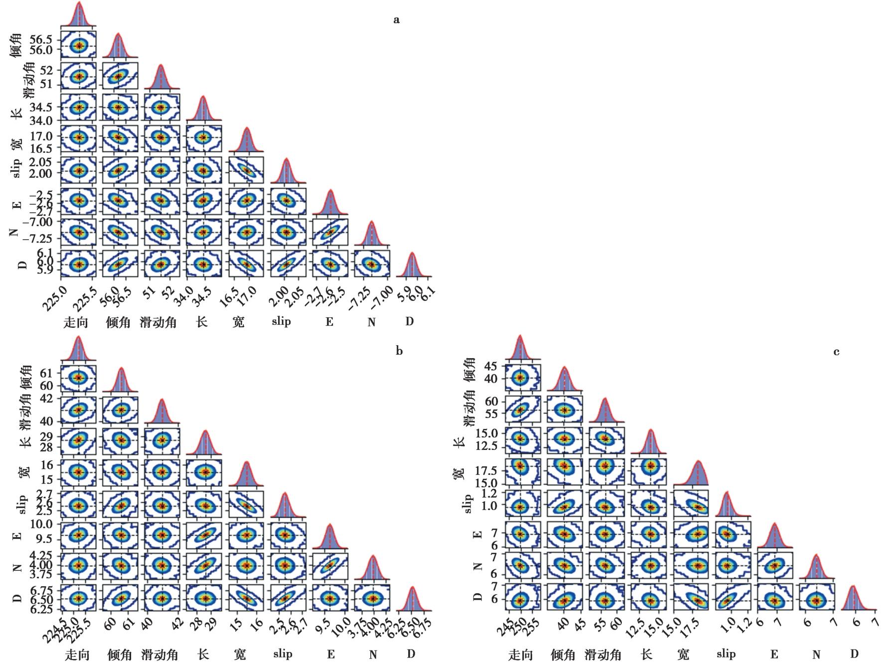
图 3 均匀断层模型几何参数的后验概率密度 a 单断层模型F1; b 双断层模型F1; c 双断层模型F2
Fig. 3 Posterior probability density of geometric parameters for the uniform fault model.
| 模型 | 走向/(°) | 倾角/(°) | 滑动角/(°) | 长度/km | 宽度/km | 滑动量/m | 上边界埋深/km |
|---|---|---|---|---|---|---|---|
| 单断层模型F1段 | 225 | 56 | 51 | 34.44 | 16.92 | 2.01 | 5.95 |
| 双断层模型F1段 | 225 | 60 | 41 | 28.62 | 15.47 | 2.55 | 6.52 |
| 双断层模型F2段 | 250 | 40 | 56 | 14.01 | 18.32 | 0.95 | 5.87 |
表 4 单断层和双断层模型最优参数结果
Table4 Optimal parameter results for single-fault and dual-fault models
| 模型 | 走向/(°) | 倾角/(°) | 滑动角/(°) | 长度/km | 宽度/km | 滑动量/m | 上边界埋深/km |
|---|---|---|---|---|---|---|---|
| 单断层模型F1段 | 225 | 56 | 51 | 34.44 | 16.92 | 2.01 | 5.95 |
| 双断层模型F1段 | 225 | 60 | 41 | 28.62 | 15.47 | 2.55 | 6.52 |
| 双断层模型F2段 | 250 | 40 | 56 | 14.01 | 18.32 | 0.95 | 5.87 |
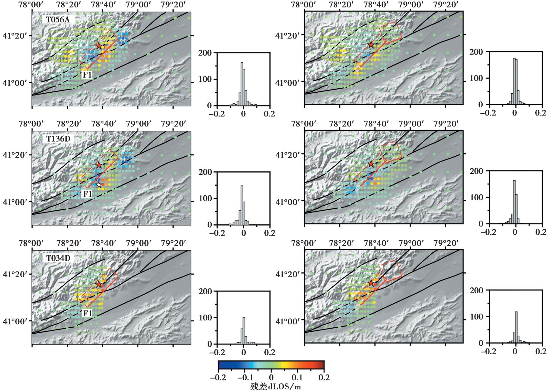
图 4 几何参数反演的单断层和双断层模型模拟残差 红色边框表示断层面的地表投影, 实线部分表示断层面上边界, 白色五角星表示GCMT给出的2024年1月30日 MW5.7 余震震中, 残差分布直方图表示残差值(单位: m)的数量分布
Fig. 4 Modeling residuals for single-fault and dual-fault models from geometric parameter inversion.
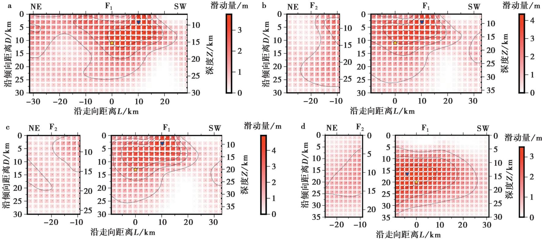
图 5 滑动分布图 a 单断层模型F1; b 双断层模型1; c 双断层模型2; d 双断层模型2的上边界延伸至地表。 黄色五角星表示矩心震中位置, 蓝色三角形标识最大滑动量, 黑色箭头方向及大小表示子断层滑动矢量
Fig. 5 Sliding distribution.
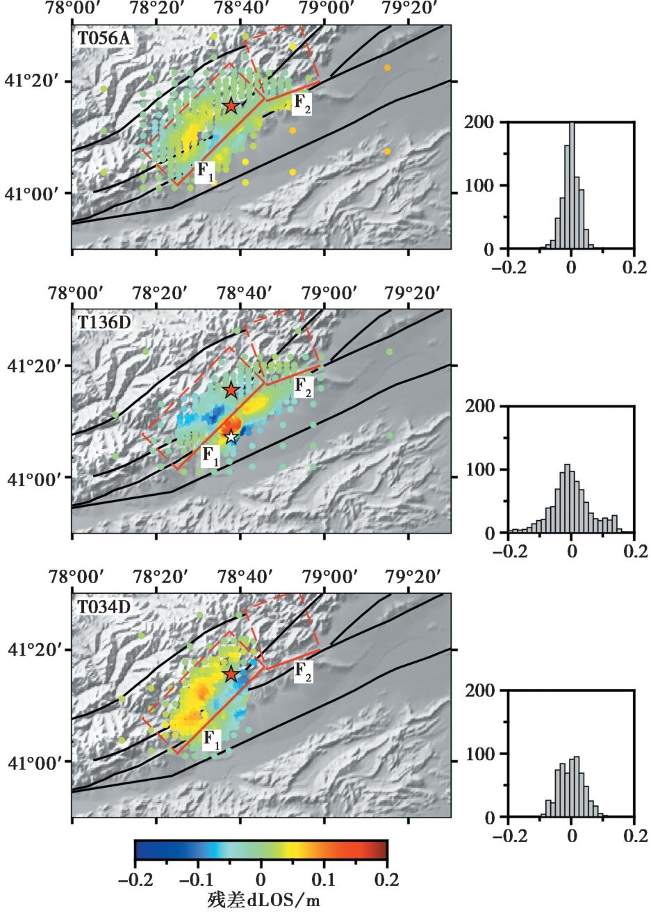
图 6 双断层模型2模拟形变场残差分布 白色五角星表示2024年1月30日5.7级余震的震中位置
Fig. 6 Residual distribution of modeled deformation field for dual-fault model 2.
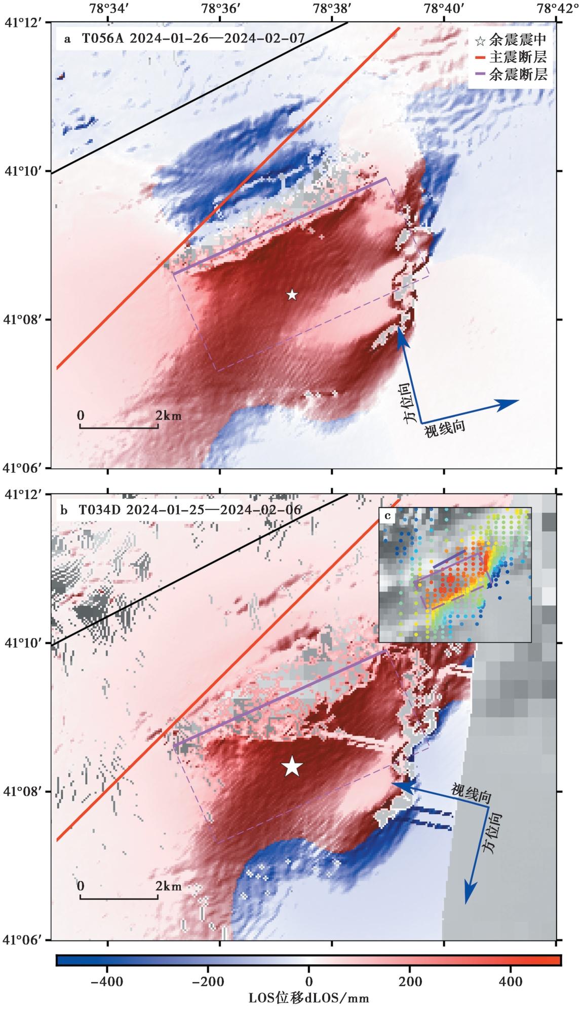
图 7 余震同震形变场和T136D模型2残差分布 a T56A同震形变场; b T34D同震形变场; c T136D模型2滑动分布残差; T056A的时间范围2024年1月26日—2月7日, T034D的时间范围2024年1月25日—2月6日; 黑色框线表示图 6中余震附近较大残差值覆盖的区域;图c中深紫色线为地表破裂位置(张博譞等, 2024)
Fig. 7 Coseismic deformation field of the aftershock and residual distribution for T136D in model 2.
| 来源 | 震中位置 | 深度/km | 走向/(°) | 倾角/(°) | 滑动角/(°) | 震级/MW |
|---|---|---|---|---|---|---|
| GCMT | 41.12°N,78.63°E | 12 | 221 | 49 | 65 | 5.7 |
| 76 | 47 | 116 | ||||
| 本研究 | 41.14°N,78.62°E | 2.8 | 65 | 58 | 89 | 5.71 |
表 5 MW5.7余震(北京时间2024-01-30, 06:27:40)震源参数
Table5 Source parameters of the MW5.7 aftershock(BJT: 2024-01-30, 06:27:40)
| 来源 | 震中位置 | 深度/km | 走向/(°) | 倾角/(°) | 滑动角/(°) | 震级/MW |
|---|---|---|---|---|---|---|
| GCMT | 41.12°N,78.63°E | 12 | 221 | 49 | 65 | 5.7 |
| 76 | 47 | 116 | ||||
| 本研究 | 41.14°N,78.62°E | 2.8 | 65 | 58 | 89 | 5.71 |
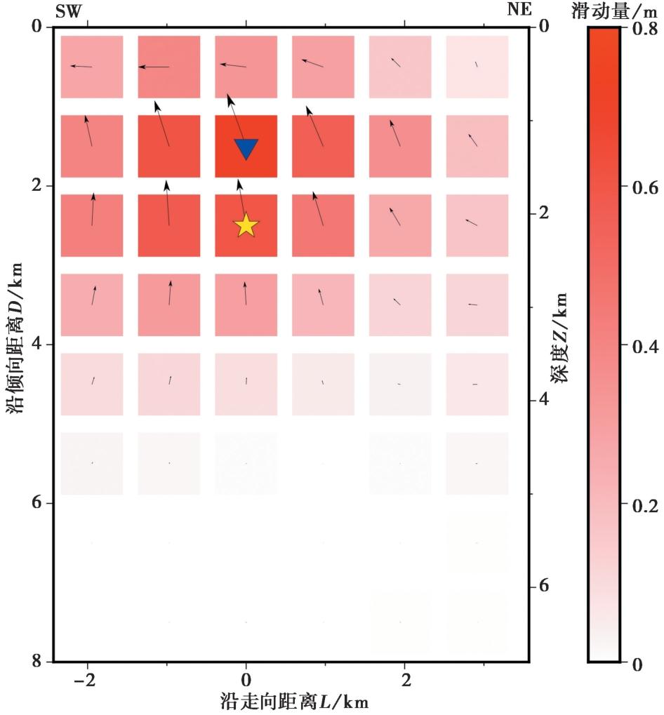
图 8 余震滑动分布
Fig. 8 Sliding distribution of the aftershock.
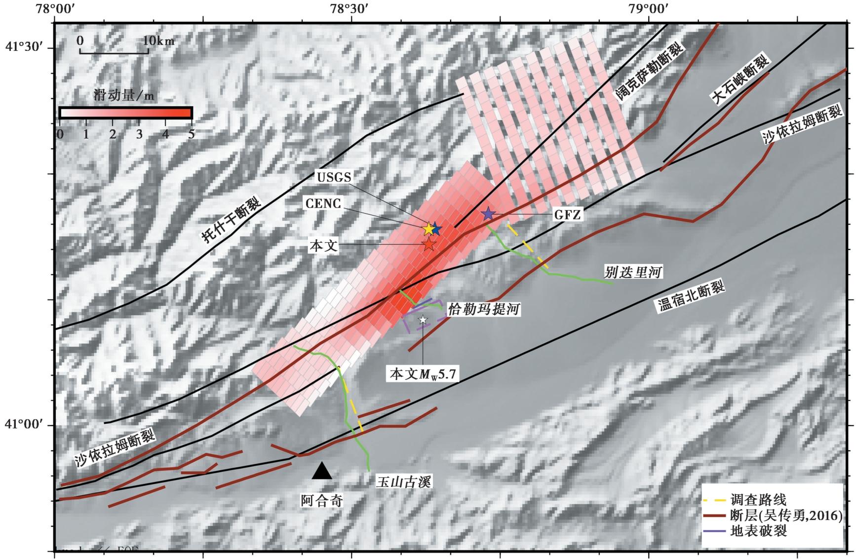
图 9 同震和余震滑动分布平面图 黄色虚线表示张博譞等(2024)的调查路线3和7; 深红色断层线来自吴传勇(2016); 绿色实线表示河流
Fig. 9 Plan view of coseismic and aftershock sliding distributions.
| [1] |
黄旺, 李杰, 陈荣柳, 等. 2024. 2024年1月23日乌什 MW7.0 地震InSAR同震形变与滑动分布特征[J]. 内陆地震, 38(2): 166-172. doi: 10.16256/j.issn.1001-8956.2024.02.009.
|
|
DOI |
|
| [2] |
李瑞, 李杰, 刘代芹, 等. 2021. 柯坪块体周缘主要断裂闭锁程度与滑动亏损速率的分布特征[J]. 中国地震, 37(4): 868-877.
|
|
|
|
| [3] |
李雨森, 李为乐, 许强, 等. 2024. 2024年新疆乌什 MS7.1 地震InSAR同震形变探测与断层滑动分布反演[J]. 成都理工大学学报(自然科学版), 51(4): 641-653.
|
|
|
|
| [4] |
梁乐, 朱彤. 2024. 新疆乌什7.1级地震救援工作需防余震风险[N]. 科技日报, 2024-01-24(3).
|
|
|
|
| [5] |
刘代芹,
DOI |
|
|
|
| [6] |
刘静, 纪晨, 张金玉, 等. 2015. 2015年4月25日尼泊尔 MW7.8 地震的孕震构造背景和特征[J]. 科学通报, 60(27): 2640-2655.
|
|
|
|
| [7] |
柳姣姣, 张永志, 郝小叶, 等. 2025. 基于Sentinel-1A的2024年新疆乌什 MW7.0 地震地表形变与断层滑动分布反演[J]. 大地测量与地球动力学, 45(2): 170-176.
|
|
|
|
| [8] |
木妮拉·局玛洪, 艾力夏提·玉山, 李瑞, 等. 2022. 2020年伽师 MS6.4 地震InSAR同震形变与滑动分布特征分析[J]. 震灾防御技术, 17(3): 549-556.
|
|
|
|
| [9] |
能懿菡, 韩炳权, 刘振江, 等. 2025. InSAR观测揭示的2024年新疆乌什 MW7.0 地震地表形变及发震断层模型[J]. 武汉大学学报(信息科学版), 50(2): 368-376.
|
|
|
|
| [10] |
王敏. 2014. 新疆乌什县地质灾害发育特征及易发性评价研究[D]. 南京: 南京大学.
|
|
|
|
| [11] |
王晓萌. 2021. 中国西部活动断块地震灾害时空对称结构与相关机理研究[D]. 西安: 陕西师范大学.
|
|
|
|
| [12] |
王子韬, 程惠红, 董培育, 等. 2020. 天山造山带及邻区孕震应力场及断裂带活动性特征的数值实验分析[J]. 地球物理学报, 63(11): 4037-4049.
DOI |
|
|
|
| [13] |
吴传勇, 阿里木江, 戴训也, 等. 2014. 西南天山迈丹断裂东段晚第四纪活动的发现及构造意义[J]. 地震地质, 36(4): 976-990. doi: 10.3969/j.issn.0253-4967.2014.04.004.
|
|
|
|
| [14] |
吴传勇. 2016. 西南天山北东东走向断裂的晚第四纪活动特征及在天山构造变形中的作用[D]. 北京: 中国地震局地质研究所.
|
|
|
|
| [15] |
闫纪元, 冯军, 张雪华, 等. 2024. 2024年1月23日新疆阿克苏地区乌什 MS7.1 地震地表变形特征初步调查[J/OL]. 北京大学学报(自然科学版) [2025-03-20].
|
|
|
|
| [16] |
杨少敏, 李杰, 王琪. 2008. GPS研究天山现今变形与断层活动[J]. 中国科学(D辑), 38(7): 872-880.
|
|
|
|
| [17] |
张博譞, 钱黎, 李涛, 等. 2024. 2024年1月23日新疆乌什 MS7.1 地震地质灾害和地表破裂[J]. 地震地质, 46(1): 220-234. doi: 10.3969/j.issn.0253-4967.2024.01.013.
|
|
|
|
| [18] |
赵磊, 陈志丹, 谢磊, 等. 2024. 2024年1月23日 MW7.0 乌什地震InSAR同震形变场和断层滑动分布[J]. 地球与行星物理论评, 55(4): 453-460.
|
|
|
|
| [19] |
赵鹏翔, 马建, 黄帅堂, 等. 2024. 乌什7.1级地震烈度评定与震害特征分析[J]. 内陆地震, 38(2): 112-120.
DOI |
|
DOI |
|
| [20] |
周德敏. 2013. 中西天山现今地壳形变特征及地震危险性分析[D]. 北京: 中国地震局地质研究所.
|
|
|
|
| [21] |
朱爽, 梁洪宝, 魏文薪, 等. 2021. 天山地震带主要活动断层现今的滑动速率及其地震矩亏损[J]. 地震地质, 43(1): 249-261. doi: 10.3969/j.issn.0253-4967.2021.01.015.
|
|
DOI |
|
| [22] |
|
| [23] |
|
| [24] |
|
| [25] |
|
| [26] |
|
| [27] |
|
| [28] |
|
| [29] |
|
| [30] |
|
| [31] |
|
| [32] |
|
| [33] |
|
| [34] |
|
| [35] |
|
| [36] |
|
| [37] |
|
| [38] |
DOI |
| [39] |
|
| [40] |
|
| [1] | 杨莹辉, 谢丽媛, 许强, 王运生, 赵晶晶, 王道明, 陈强. 2023年积石山MW6.1 地震InSAR同震形变与震间断裂运动机制[J]. 地震地质, 2025, 47(5): 1416-1437. |
| [2] | 刘胜, 谈洪波, 杨光亮, 孟恒舟, 秦海涛, 王嘉沛, 黄敏夫. 2025年西藏定日MW7.1地震破裂过程反演[J]. 地震地质, 2025, 47(3): 777-788. |
| [3] | 陈建波, 郑黎明, 李涛, 陈杰, 姚远, 钱黎, 张博譞, 胡宗凯, 刘冠伸, 李金. 2024年1月23日新疆乌什MS7.1地震宏观震中与地质灾害调查[J]. 地震地质, 2025, 47(2): 561-576. |
| [4] | 陈长云, 尹海权. 新疆地区现今地壳变形特征与强震危险性概率预测[J]. 地震地质, 2025, 47(2): 384-404. |
| [5] | 徐晶, 季灵运, 刘传金. 2022年泸定MS6.8地震震前区域变形背景及同震形变特征[J]. 地震地质, 2024, 46(3): 645-664. |
| [6] | 王雨晴, 冯万鹏, 张培震. 交角约90°共轭断裂的现今形变及对构造应力场的指示意义——以2019年MW≥6.4菲律宾地震序列为例[J]. 地震地质, 2022, 44(2): 313-332. |
| [7] | 徐芳, 鲁人齐, 王帅, 江国焰, 龙锋, 王晓山, 苏鹏, 刘冠伸. 基于多元约束方法的2020年四川青白江MS5.1地震构造研究[J]. 地震地质, 2022, 44(1): 220-237. |
| [8] | 邱江涛, 季灵运, 刘雷, 刘传金. 2020年西藏尼玛MW6.3地震的InSAR同震形变与构造意义[J]. 地震地质, 2021, 43(6): 1586-1599. |
| [9] | 徐晓雪, 季灵运, 朱良玉, 王光明, 张文婷, 李宁. 漾濞MS6.4地震同震形变特征及发震构造探讨[J]. 地震地质, 2021, 43(4): 771-789. |
| [10] | 华俊, 赵德政, 单新建, 屈春燕, 张迎峰, 龚文瑜, 王振杰, 李成龙, 李彦川, 赵磊, 陈晗, 范晓冉, 王绍俊. 2021年青海玛多MW7.3地震InSAR的同震形变场、断层滑动分布及其对周边区域的应力扰动[J]. 地震地质, 2021, 43(3): 677-691. |
| [11] | 王绍俊, 刘云华, 单新建, 屈春燕, 张国宏, 解朝娣, 赵德政, 范晓冉, 华俊, 梁诗明, 张克亮, 代成龙. 2021年云南漾濞MS6.4地震同震地表形变与断层滑动分布[J]. 地震地质, 2021, 43(3): 692-705. |
| [12] | 贾蕊, 张国宏, 解朝娣, 单新建, 张迎峰, 李成龙, 黄自成. 2019年巴基斯坦新米尔普尔MW6.0地震的同震形变场与断层滑动分布反演[J]. 地震地质, 2021, 43(3): 600-613. |
| [13] | 温少妍, 单新建, 张迎峰, 刘云华, 汪驰升, 宋春燕. 基于Sentinel-1A的新疆阿克陶MS6.7地震同震形变与滑动分布特征[J]. 地震地质, 2020, 42(6): 1401-1416. |
| [14] | 郑博文, 龚文瑜, 温少妍, 张迎峰, 单新建, 宋小刚, 刘云华. 基于Sentinel-1A的2016年青海门源MW5.9地震发震构造特征[J]. 地震地质, 2018, 40(4): 872-882. |
| [15] | 张迎峰, 张国宏, 单新建, 温少妍. 2015年尼泊尔GorkhaMW7.9地震与KodariMW7.3地震InSAR数据反演及其应力触发分析[J]. 地震地质, 2017, 39(1): 104-116. |
| 阅读次数 | ||||||
|
全文 |
|
|||||
|
摘要 |
|
|||||
