地震地质 ›› 2025, Vol. 47 ›› Issue (2): 384-404.DOI: 10.3969/j.issn.0253-4967.2025.02.20240151
陈长云( ), 尹海权
收稿日期:2024-12-01
修回日期:2025-03-10
出版日期:2025-04-20
发布日期:2025-06-07
作者简介:陈长云, 男, 1981年生, 2014年于中国地震局地质研究所获构造地质学专业博士学位, 高级工程师, 主要研究方向为活动构造与地壳变形特征研究, E-mail: ccy_666@163.com。
基金资助:
CHEN Chang-yun(), YIN Hai-quan
Received:2024-12-01
Revised:2025-03-10
Online:2025-04-20
Published:2025-06-07
摘要:
文中基于GNSS速度场结果利用球面最小二乘配置方法计算获取2024年1月23日乌什 MS7.1 地震前新疆地区现今的地壳变形特征。基于活动块体基本概念, 结合区域地震地质数据将新疆及其邻区划分为17个活动块体, 利用三维弹性块体模型计算了活动块体及其边界断裂带的滑动速率。基于块体划分结果, 将研究区划分为91个潜在地震危险区。将基于GNSS速度场反演得到的断层滑动速率、 面应变率等大地测量结果应用到经典强震危险性概率预测中, 给出各潜在危险区的强震危险性概率预测结果, 并综合分析了乌什7.1级地震与区域地壳变形特征和强震概率预测结果之间的关系。结果表明, 新疆地区的速度场、 应变率场和主要边界断裂带的滑动速率均具有明显的分区特征。速度场方向变化与动力背景有关, 大小变化与天山构造带的吸收作用有关。南天山西段主压应变特征最为明显, 其次是阿尔金断裂带。各块体边界断裂带中NW走向的断裂带以右旋走滑运动为主, NE或近EW向的断裂带以左旋走滑运动为主, 整个天山地区以挤压变形为主。基于乌什地震震前数据获取的高概率危险区段主要集中在南天山西段, 包括NE走向的迈丹断裂带、 那拉提断裂带和乌孙山脊断裂带, NW走向的塔拉斯-费尔干纳断裂带和克孜勒陶断裂带北西段等。北天山强震危险概率相对较高的区域包括阜康断裂带、 博格达断裂带西段等。乌什7.1级地震发生在高发震概率迈丹断裂带上, 验证了方法的有效性。
陈长云, 尹海权. 新疆地区现今地壳变形特征与强震危险性概率预测[J]. 地震地质, 2025, 47(2): 384-404.
CHEN Chang-yun, YIN Hai-quan. CRUSTAL DEFORMATION CHARACTERISTICS AND PROBABILITY PREDICTION OF STRONG EARTHQUAKE RISK IN XINJIANG AND ITS ADJACENT REGION[J]. SEISMOLOGY AND GEOLOGY, 2025, 47(2): 384-404.

图 1 新疆地区的主要活动断裂带、 地震活动和GNSS速度场 图中断裂带数据据文献(徐锡伟等, 2016); 地震数据来自中国地震台网中心 ① ; 震源机制解下载自网站 ② ; GNSS速度场据文献(Wang et al., 2020)。F1额尔齐斯断裂带; F2可可托海-二台断裂带; F3北塔山前断裂带; F4纸坊断裂带; F5哈密断裂带; F6洛包泉-咸泉子断裂带; F7博格达南缘断裂带; F8博格达北缘断裂带; F9博阿断裂带; F10喀什河断裂带; F11那拉提断裂带; F12迈丹断裂带; F13柯坪断裂带; F14秋里塔格断裂带; F15兴地断裂带; F16克敏断裂带; F17大扎莱尔断裂带; F18塔拉斯-费尔干纳断裂带; F19克孜勒陶断裂带; F20阿尔金断裂带; F21达尔布特断裂带
Fig. 1 Major faults, seismic activity and GNSS velocity field respective to Eurasian frame in Xinjiang and its adjacent regions.
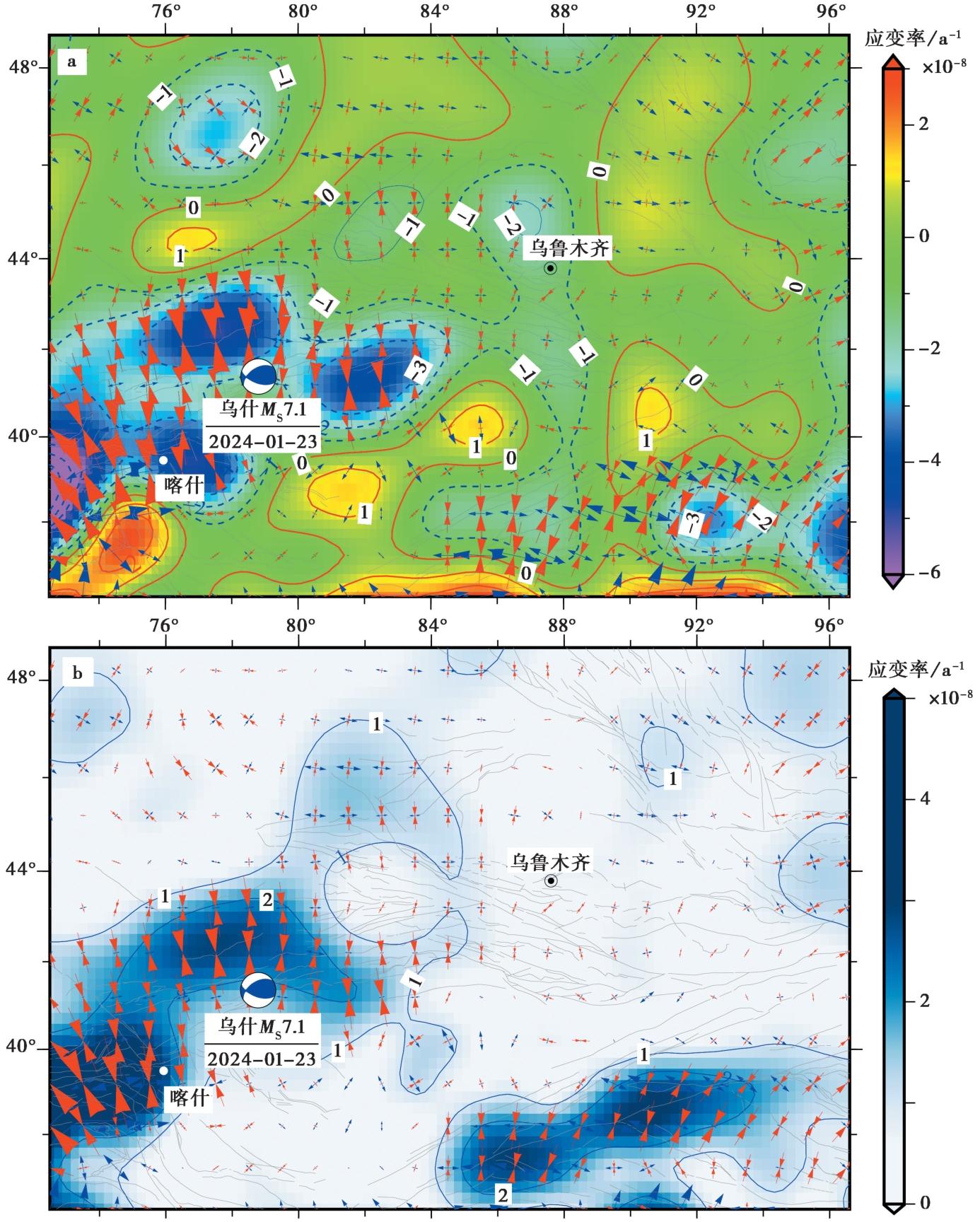
图 2 基于GNSS的新疆地区的地壳变形特征 a 主应变率和面应变率; b 主应变率和最大剪切应变率
Fig. 2 Continuum deformation field in Xinjiang and its adjacent regions based on GNSS.

图 3 新疆地区块体划分和块体运动(a)及其残差分布(b) 图中红色和蓝色线段分别为张培震等(2003)给出的一级和二级活动地块的边界; 棕色线段为本文给出的块体边界。块体名称: B1塔里木; B2柯坪; B3那拉提南; B4那拉提北; B5克敏东; B6博乐; B7焉耆; B8阜康; B9博格达; B10哈密; B11清河; B12海西; B13塔什库尔干; B14乌恰; B15克敏西; B16巴尔喀什; B17塔城
Fig. 3 Block division and motion in Xinjiang and its adjacent(a)and residuals of block motion(b).

图 4 基于震源深度和三维弹性块体模型拟合确定新疆地区最优闭锁深度 a 小地震精定位和1900年以来5.0级以上地震分布; 黑色框为投影范围; b、 c 分别为跨南天山和北天山中东段震源深度剖面; d、 e 分别为b和c所示剖面对应的震源深度频次统计结果; f 最优闭锁深度模型拟合结果
Fig. 4 The optimal locking depth in Xinjiang and adjacent areas determined based on focal depths and model fitting results.

图 5 新疆地区块体边界断裂的运动特征 a 走滑运动特征(红色左旋, 蓝色右旋); b 张压运动特征(红色拉张, 蓝色挤压)
Fig. 5 Kinematic characteristics of block boundary faults in Xinjiang and its adjacent regions.
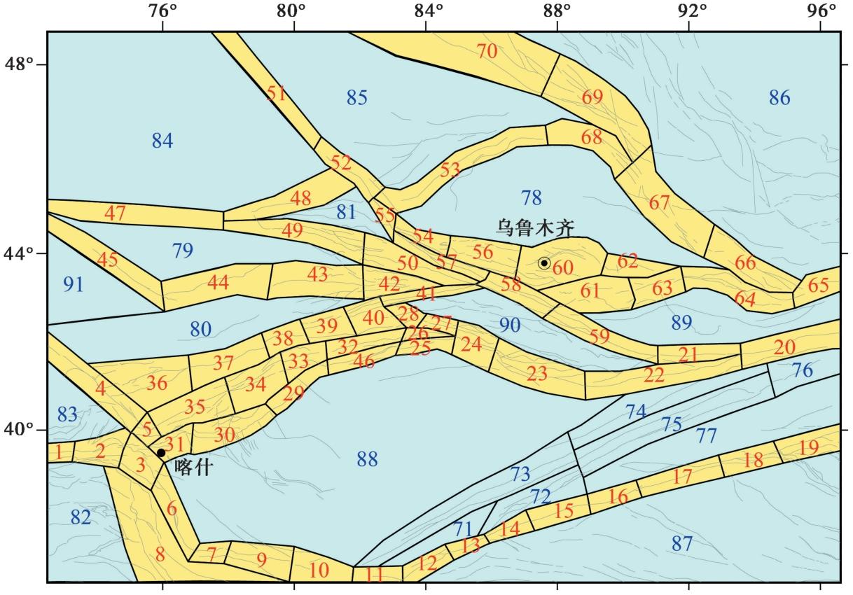
图 6 新疆地区潜在地震危险区划分结果 黄色为主要潜在地震危险区; 青色为次级潜在地震危险区; 序号为潜在危险区的编号
Fig. 6 Results of potential earthquake hazard zone delineation in Xinjiang and its adjacent regions.
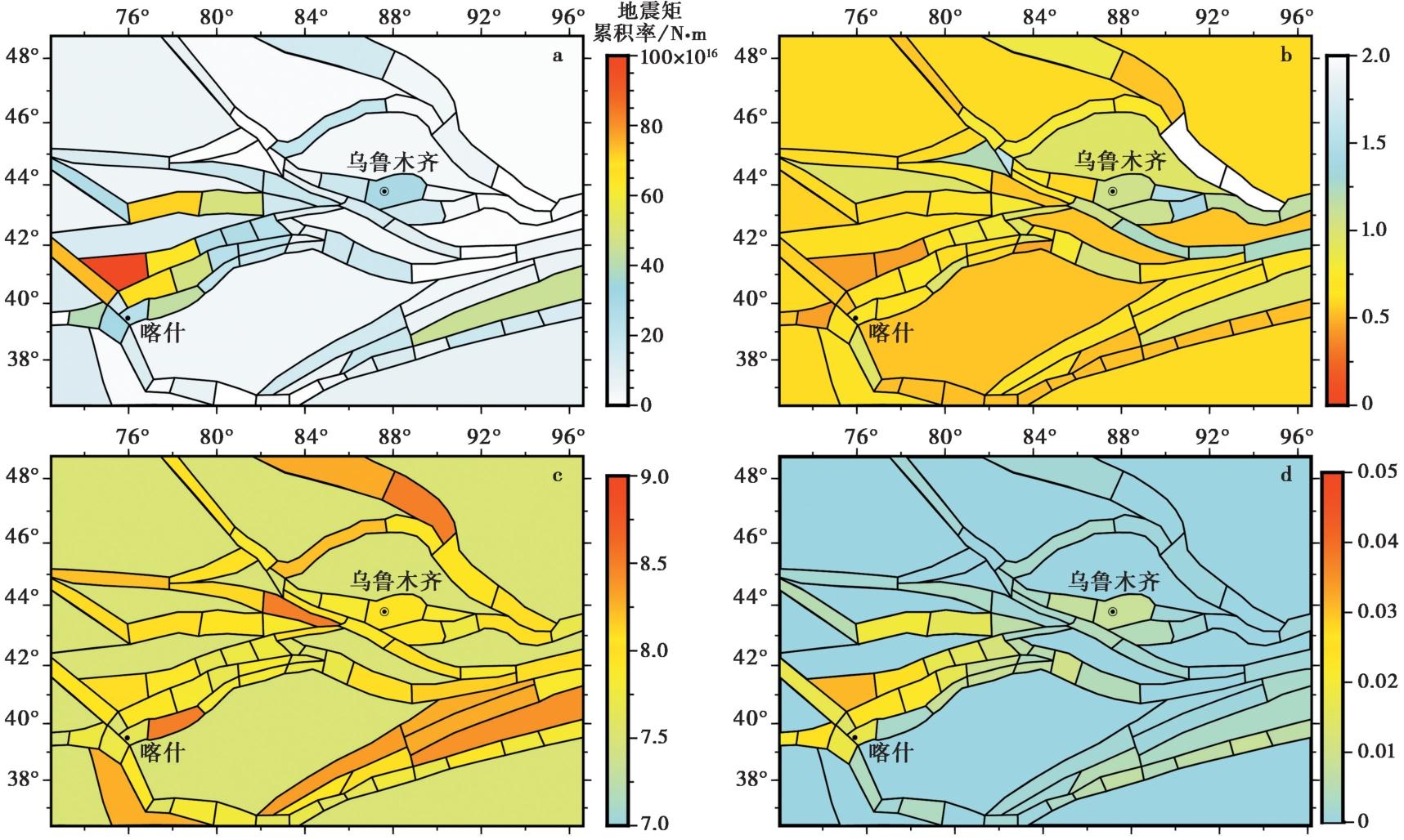
图 7 新疆地区潜在地震危险区内的地震活动参数 a 地震矩累积率; b b值; c 最大潜在震级; d 7级以上地震年均地震频次
Fig. 7 Parameters of seismic activity in potentially earthquake risk regions.
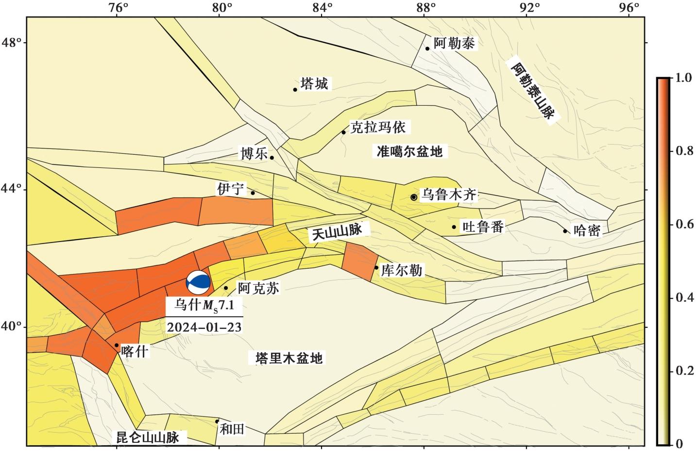
图 8 新疆地区未来50a的7级以上强震的发震概率
Fig. 8 Probability of occurrence of strong earthquakes larger than 7 in Xinjiang and its adjacent regions in the next 50 years.
| [1] |
程维明, 柴慧霞, 周成虎, 等. 2009. 新疆地貌空间分布格局分析[J]. 地理研究, 28(5): 1157-1169.
|
|
|
|
| [2] |
邓起东, 张培震. 2000. 史前古地震的逆断层崩积楔[J]. 科学通报, 45(6): 650-655.
|
|
|
|
| [3] |
邓起东, 张培震, 冉勇康, 等. 2002. 中国活动构造基本特征[J]. 中国科学(D辑), 32(12): 1020-1030.
|
|
|
|
| [4] |
冯先岳. 1997. 新疆古地震[M]. 乌鲁木齐: 新疆科技卫生出版社.
|
|
|
|
| [5] |
江在森, 马宗晋, 张希, 等. 2003. GPS初步结果揭示的中国大陆水平应变场与构造变形[J]. 地球物理学报, 46(3): 352-358.
|
|
|
|
| [6] |
江在森, 武艳强. 2012. 地壳形变与强震地点预测问题与认识[J]. 地震, 32(2): 8-21.
|
|
|
|
| [7] |
江在森, 杨国华, 王敏, 等. 2006. 中国大陆地壳运动与强震关系研究[J]. 大地测量与地球动力学, 26(3): 1-9.
|
|
|
|
| [8] |
李安, 杨晓平, 黄伟亮, 等. 2011. 焉耆盆地北缘哈尔莫敦背斜区的活动断裂及其形成机制[J]. 地震地质, 33(4): 789-803. doi: 10.3969/j.issn.0253-4967.2011.04.005.
|
|
DOI |
|
| [9] |
李桂荣, 孙小旭, 王晓强, 等. 2016. 基于GNSS的博阿断裂活动性分析[J]. 内陆地震, 30(4): 306-313.
|
|
|
|
| [10] |
李杰, 刘代芹, 王琪, 等. 2014. 基于GPS研究天山西南地区现今应变场特征[J]. 地震研究, 37(2): 197-203.
|
|
|
|
| [11] |
M7专项工作组. 2012. 中国大陆大地震中-长期危险性研究[M]. 北京: 地震出版社.
|
|
The Working Group of M7. 2012. Study on the Mid-to Long-term Potential of Large Earthquakes on the Chinese Continent[M]. Seismological Press, Beijing. (in Chinese)
|
|
| [12] |
马建, 吴国栋. 2019. 博-阿断裂带中东段晚第四纪以来滑动速率[J]. 高原地震, 31(1): 20-25.
|
|
|
|
| [13] |
孟国杰, 申旭辉,
|
|
|
|
| [14] |
牛之俊, 游新兆, 杨少敏. 2007. 利用GPS分析天山现今地壳形变特征[J]. 大地测量与地球动力学, 27(2): 1-9.
|
|
|
|
| [15] |
庞亚瑾, 武艳强, 苏广利, 等. 2024. 西南天山迈丹断裂周缘地壳应力演化及地震危险性分析[J]. 岩石学报, 40(12): 4020-4029.
|
|
|
|
| [16] |
沈军, 汪一鹏, 李莹甄, 等. 2003. 中国新疆天山博阿断裂晚第四纪右旋走滑运动特征[J]. 地震地质, 25(2): 183-194.
|
|
|
|
| [17] |
石耀霖, 朱守彪. 2006. 用GPS位移资料计算应变方法的讨论[J]. 大地测量与地球动力学, 26(1): 1-8.
|
|
|
|
| [18] |
王敏, 沈正康, 牛之俊, 等. 2003. 现今中国大陆地壳运动与活动块体模型[J]. 中国科学(D辑), 33(S1): 21-32.
|
|
|
|
| [19] |
王芃, 邵志刚, 刘琦, 等. 2019. 基于多学科物理观测的地震概率预测方法在川滇地区的应用[J]. 地球物理学报, 62(9): 3448-3463.
DOI |
|
|
|
| [20] |
王子韬, 程惠红, 董培育, 等. 2020. 天山造山带及邻区孕震应力场及断裂带活动性特征的数值实验分析[J]. 地球物理学报, 63(11): 4037-4049.
DOI |
|
|
|
| [21] |
吴传勇, 阿里木江, 戴训也, 等. 2014. 西南天山迈丹断裂东段晚第四纪活动的发现及构造意义[J]. 地震地质, 36(4): 976-990. doi: 10.3969/j.issn.0253-4967.2014.04.004.
|
|
DOI |
|
| [22] |
武艳强, 江在森, 杨国华, 等. 2009. 利用最小二乘配置在球面上整体解算GPS应变场的方法及应用[J]. 地球物理学报, 52(7): 1707-1714.
|
|
|
|
| [23] |
武艳强, 江在森, 朱爽, 等. 2020. 中国大陆西部GNSS变形特征及其与M≥7.0强震孕育的关系[J]. 中国地震, 36(4): 756-766.
|
|
|
|
| [24] |
徐佳静, 韩光洁, 席楠, 等. 2024. 2024年1月23日新疆乌什7.1级地震震源参数的初步分析[J]. 中国地震, 40(1): 260-270.
|
|
|
|
| [25] |
徐锡伟, 韩竹军, 杨晓平, 等. 2016. 中国及邻近地区地震构造图[CM]. 北京: 地震出版社.
|
|
|
|
| [26] |
徐锡伟, 闻学泽, 郑荣章, 等. 2003. 川滇地区活动块体最新构造变动样式及其动力来源[J]. 中国科学(D辑), 33(S1): 151-162.
|
|
|
|
| [27] |
徐锡伟, 吴熙彦, 于贵华, 等. 2017. 中国大陆高震级地震危险区判定的地震地质学标志及其应用[J]. 地震地质, 39(2): 219-275. doi: 10.3969/j.issn.0253-4967.2017.02.001.
|
|
DOI |
|
| [28] |
杨晓平, 李安, 黄伟亮, 等. 2011. 天山北麓活动背斜区河流阶地与古地震事件[J]. 地震地质, 33(4): 739-751. doi: 10.3969/j.issn.0253-4967.2011.04.001.
|
|
|
|
| [29] |
杨晓平, 冉勇康, 宋方敏, 等. 2006. 西南天山柯坪逆冲推覆构造带的地壳缩短分析[J]. 地震地质, 28(2): 194-204.
|
|
|
|
| [30] |
杨晓平, 沈军. 2000. 天山内部博罗可努断裂精河-阿拉山口段晚更新世以来的活动特征[J]. 地震地质, 22(3): 305-315.
|
|
|
|
| [31] |
张培震. 2003. 天山及其前陆盆地的晚新生代构造变形[J]. 科学通报, 48(24): 2499-2500.
|
|
|
|
| [32] |
张培震, 邓起东, 张国民, 等. 2003. 中国大陆的强震活动与活动地块[J]. 中国科学(D辑), 33(S1): 12-20.
|
|
|
|
| [33] |
|
| [34] |
|
| [35] |
|
| [36] |
|
| [37] |
|
| [38] |
|
| [39] |
|
| [40] |
|
| [41] |
|
| [42] |
|
| [43] |
|
| [44] |
|
| [45] |
|
| [46] |
|
| [47] |
|
| [48] |
|
| [49] |
|
| [50] |
|
| [51] |
|
| [52] |
|
| [53] |
|
| [54] |
PMID |
| [55] |
PMID |
| [56] |
|
| [57] |
|
| [58] |
|
| [59] |
|
| [60] |
|
| [61] |
|
| [62] |
|
| [63] |
|
| [64] |
|
| [65] |
|
| [66] |
|
| [67] |
|
| [68] |
PMID |
| [69] |
|
| [70] |
|
| [71] |
|
| [72] |
|
| [73] |
|
| [74] |
|
| [75] |
|
| [76] |
|
| [77] |
|
| [1] | 常玉巧, 张会平, 赵旭东. 青藏高原东南缘小江断裂带晚第四纪活动性研究进展[J]. 地震地质, 2026, 48(2): 279-313. |
| [2] | 徐伟, 李光涛, 程理, 邹子南. 毛毛山南缘断裂石板沟至南泥湾一带晚第四纪活动特征[J]. 地震地质, 2026, 48(2): 386-402. |
| [3] | 陈艳文, 袁道阳, 姚赟胜, 于锦超, 文亚猛, 苏瑞欢, 孙浩. 祁连山东段玛雅雪山断裂晚第四纪活动特征及其构造意义[J]. 地震地质, 2025, 47(6): 1566-1585. |
| [4] | 高扬, 吴中海, 韩帅, 田婷婷. 2025年定日MS6.8地震发震断层(登么错断裂)晚第四纪垂直滑动速率[J]. 地震地质, 2025, 47(3): 689-706. |
| [5] | 张盛峰, 张永仙. 针对地震科考工作的可操作性余震概率预测及检验——以西藏定日 MS6.8 地震为例[J]. 地震地质, 2025, 47(3): 835-849. |
| [6] | 陈子龙, 刘刚, 李琦, 陈威, 赵昕宇, 林牧, 陶隆文, 乔学军, 聂兆生. 2024年乌什MW7.0地震InSAR同震形变与发震构造[J]. 地震地质, 2025, 47(2): 429-447. |
| [7] | 朱爽, 郭南男, 庞亚瑾. 西南天山柯坪冲断带断层形变特征及地震危险性[J]. 地震地质, 2025, 47(2): 448-462. |
| [8] | 陈建波, 郑黎明, 李涛, 陈杰, 姚远, 钱黎, 张博譞, 胡宗凯, 刘冠伸, 李金. 2024年1月23日新疆乌什MS7.1地震宏观震中与地质灾害调查[J]. 地震地质, 2025, 47(2): 561-576. |
| [9] | 许斌斌, 张逸鹏, 卢乐浚, 田晴映, 杨雪, 王洋, 张培震. 2025年3月缅甸 MS7.9 地震的发震构造[J]. 地震地质, 2025, 47(2): 649-670. |
| [10] | 陈倩, 张竹琪. 太原盆地地壳形变特征及其反映的强震危险性[J]. 地震地质, 2025, 47(1): 189-213. |
| [11] | 花春雨, 石峰, 魏占玉. 龙门山断裂带映秀-北川断裂白沙河段滑动速率[J]. 地震地质, 2024, 46(6): 1295-1313. |
| [12] | 陈毅, 赵斌, 熊维, 王伟, 余鹏飞, 余建胜, 王东振, 陈威, 乔学军. InSAR数据约束的鲜水河断裂带北西段震间滑动速率及浅部蠕滑特征[J]. 地震地质, 2023, 45(5): 1074-1091. |
| [13] | 杨源源, 李鹏飞, 路硕, 疏鹏, 潘浩波, 方良好, 郑海刚, 赵朋, 郑颖平, 姚大全. 郯庐断裂带中段F5断裂淮河-女山湖段的古地震与垂直滑动速率[J]. 地震地质, 2022, 44(6): 1365-1383. |
| [14] | 张秀丽, 熊建国, 张培震, 刘晴日, 姚勇, 钟岳志, 张会平, 李有利. 中更新世晚期以来中条山北麓断层滑动速率研究[J]. 地震地质, 2022, 44(6): 1403-1420. |
| [15] | 邵延秀, 刘静, 高云鹏, 王文鑫, 姚文倩, 韩龙飞, 刘志军, 邹小波, 王焱, 李云帅, 刘璐. 同震地表破裂的位移测量与弥散变形分析——以2021年青海玛多MW7.4地震为例[J]. 地震地质, 2022, 44(2): 506-523. |
| 阅读次数 | ||||||
|
全文 |
|
|||||
|
摘要 |
|
|||||
