地震地质 ›› 2022, Vol. 44 ›› Issue (4): 992-1010.DOI: 10.3969/j.issn.0253-4967.2022.04.011
李宗旭1)( ), 贺日政1),*(), 冀战波1), 李娱兰2), 牛潇1)
收稿日期:2021-05-31
修回日期:2021-10-10
出版日期:2022-08-20
发布日期:2022-09-23
通讯作者:
贺日政
作者简介:李宗旭, 男, 1997年生, 现为中国地质科学院地球探测与信息技术专业在读博士研究生, 研究方向为青藏高原深部结构探测与构造研究, E-mail: lizongxu19@mails.ucas.ac.cn。
基金资助:
LI Zong-xu1)(), HE Ri-zheng1),*(), JI Zhan-bo1), LI Yu-lan2), NIU Xiao1)
Received:2021-05-31
Revised:2021-10-10
Online:2022-08-20
Published:2022-09-23
Contact:
HE Ri-zheng
摘要:
文中收集了由西藏地震台网和同期流动观测台网记录到的2009年7月24日西藏尼玛 MS5.6 地震的波形数据, 应用Hypo2000方法对该地震开展了绝对到时精定位。因定位所使用的台站分布均匀, 与仅使用固定台站数据的定位结果(31.30°N, 86.10°E)相比, 我们得到的尼玛地震的精定位结果(31.08°N, 86.05°E)更为可靠, 该结果与通过矩张量定位方法(GCMT)获得的结果(31.05°N, 86.10°E)较为一致。在获得震中定位结果的基础上, 使用CAP方法得到该地震的震源深度(海拔高度为0m起算)为19.3km, 该地震具有走滑断裂性质。结合地震所处的应力场特征对本次地震的2个节面(节面Ⅰ, 走向为220°, 倾角为82°, 滑动角为-17°; 节面Ⅱ, 走向为314°, 倾角为73°, 滑动角为-171°)的剪应力和正应力进行计算, 发现该地震的震源机制与区域内SN向挤压、 EW向扩张的应力场特征相吻合。参考震中所在位置的1︰25万区域地质调查结果, 结合该区EW向窝藏断裂和NWW向扎拉断裂所限定的近EW向走滑断裂带的特征推断, 该地震具有EW向右旋走滑性质。根据区域地表地质及区域地球物理揭示的深部结构特征推测, 该地震发生在当惹雍错裂谷西侧约30km处的狮泉河-拉果错-永珠-嘉黎蛇绿岩混杂岩带下方中上地壳间的低速软弱层(即壳内脆韧性转换带)顶部, 暗示了晚中生代形成的狮泉河-拉果错-永珠-嘉黎蛇绿岩混杂岩带在高原快速隆升过程中以EW向走滑方式再次活化。这一解释对理解青藏高原EW向伸展作用有着重要意义。
中图分类号:
李宗旭, 贺日政, 冀战波, 李娱兰, 牛潇. 2009年7月24日西藏尼玛MS5.6地震的震源机制及其构造意义[J]. 地震地质, 2022, 44(4): 992-1010.
LI Zong-xu, HE Ri-zheng, JI Zhan-bo, LI Yu-lan, NIU Xiao. THE FOCAL MECHANISM AND TECTONIC SIGNIFICANCE OF THE MS5.6 EARTHQUAKE ON JULY 24, 2009 IN NIMA, TIBET[J]. SEISMOLOGY AND GEOLOGY, 2022, 44(4): 992-1010.
| 发震时间(UTC时间) | 东经/(°) | 北纬/(°) | 深度/km | 震级 | 数据来源 |
|---|---|---|---|---|---|
| 2009-07-24, T03:11:58 | 86.10 | 31.30 | 33.0 | MS5.6 | 中国地震台网中心 |
| 2009-07-24, T03:12:00 | 86.00 | 31.28 | 7.0 | MS5.7 | 西藏地震台网 |
| 2009-07-24, T03:12:00 | 86.00 | 31.28 | 7.0 | MW5.8 | 沈小七等, |
| 2009-07-24, T03:11:57 | 85.96 | 31.17 | 13.3 | MW5.8 | IRIS |
| 2009-07-24, T03:12:02 | 86.10 | 31.05 | 28.1 | MW5.8 | GCMT |
| 2009-07-24, T03:11:56 | 85.90 | 31.16 | 13.4 | MW5.8 | USGS |
| 2009-07-24, T03:11:56 | 85.97 | 31.20 | 10.0 | MW5.7 | EMSC |
| 2009-07-24, T03:11:58 | 85.90 | 31.10 | 17.0 | M5.6 | GFZ |
| 2009-07-24, T03:11:55 | 86.05 | 31.08 | 19.3 | MW5.57 | 本文 |
表1 本文与其他机构计算的2009年7月24日西藏尼玛 MS5.6 地震的参数对比(引自沈小七等, 2015)
Table 1 Parameters of the MS5.6 earthquake on July 24, 2009 in Nima, Tibet calculated by different institutions.(after SHEN Xiao-qi et al., 2015)
| 发震时间(UTC时间) | 东经/(°) | 北纬/(°) | 深度/km | 震级 | 数据来源 |
|---|---|---|---|---|---|
| 2009-07-24, T03:11:58 | 86.10 | 31.30 | 33.0 | MS5.6 | 中国地震台网中心 |
| 2009-07-24, T03:12:00 | 86.00 | 31.28 | 7.0 | MS5.7 | 西藏地震台网 |
| 2009-07-24, T03:12:00 | 86.00 | 31.28 | 7.0 | MW5.8 | 沈小七等, |
| 2009-07-24, T03:11:57 | 85.96 | 31.17 | 13.3 | MW5.8 | IRIS |
| 2009-07-24, T03:12:02 | 86.10 | 31.05 | 28.1 | MW5.8 | GCMT |
| 2009-07-24, T03:11:56 | 85.90 | 31.16 | 13.4 | MW5.8 | USGS |
| 2009-07-24, T03:11:56 | 85.97 | 31.20 | 10.0 | MW5.7 | EMSC |
| 2009-07-24, T03:11:58 | 85.90 | 31.10 | 17.0 | M5.6 | GFZ |
| 2009-07-24, T03:11:55 | 86.05 | 31.08 | 19.3 | MW5.57 | 本文 |

图1 研究区的台站分布、 定位结果及震源机制解 a 欧亚板块和印度板块的地形图, 红色矩形为图1b所示区域, 地形数据为STRM15+数据; b 蓝色五角星为USGS定位结果及震源机制解; 绿色五角星为GCMT定位结果及震源机制解; 红色五角星为本文精定位结果及震源机制解。图1b中当惹雍错裂谷的位置见图4c。BNS 班公湖-怒江缝合带; SYMZ 狮泉河-永珠-那木错-嘉黎蛇绿岩混杂带; LMF 珞巴对-米拉山断裂带; IYS 雅鲁藏布江缝合带; QT 羌塘地体; NLT 北拉萨地体; MLT 中拉萨地体; SLT 南拉萨地体; HIMALAYA 喜马拉雅。构造线、 缝合线改编自文献(潘桂棠等, 2006; 徐梦婧, 2014)
Fig. 1 Map of station distribution, earthquake location result, and focal mechanism in the study area.
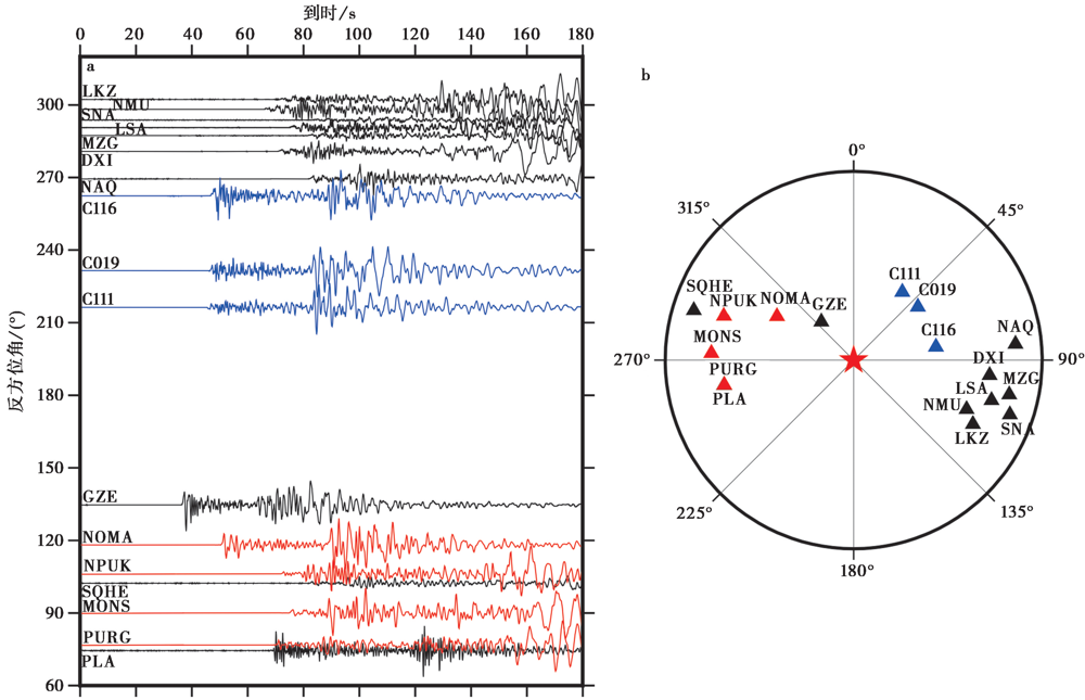
图2 2009年7月24日西藏尼玛 MS5.6 地震事件的波形及定位所使用的台站分布 a 各台站记录到的Z分量的波形示意图(按反方位角排列), 其中黑色代表西藏固定台网, 红色代表Western Tibet台网, 蓝色代表流动观测TITAN台阵; b 以地震事件为中心, 各台站按方位角排列分布
Fig. 2 Waveform of the MS5.6 earthquake on July 24, 2009 in Nima, Tibet and stations’ distribution used in the earthquake location.
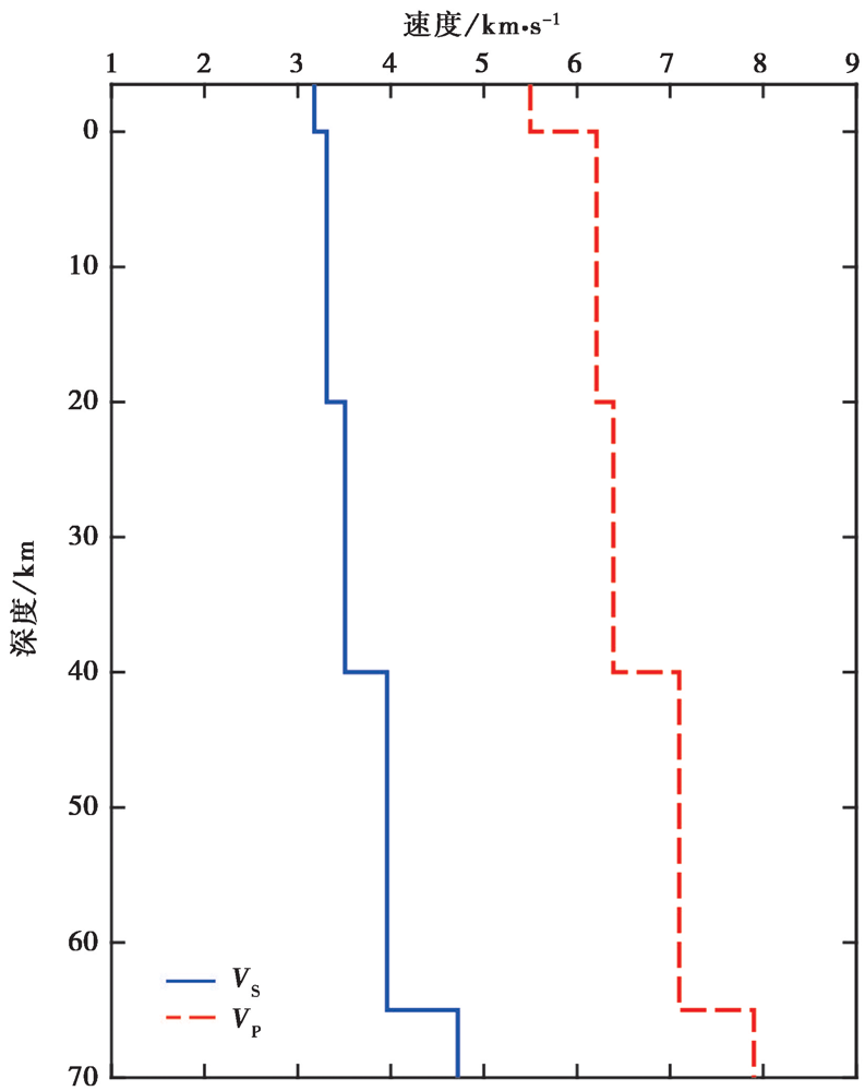
图3 本文使用的地壳速度模型(牛潇等, 2021)
Fig. 3 Crustal velocity model used in this study(NIU Xiao et al., 2021).
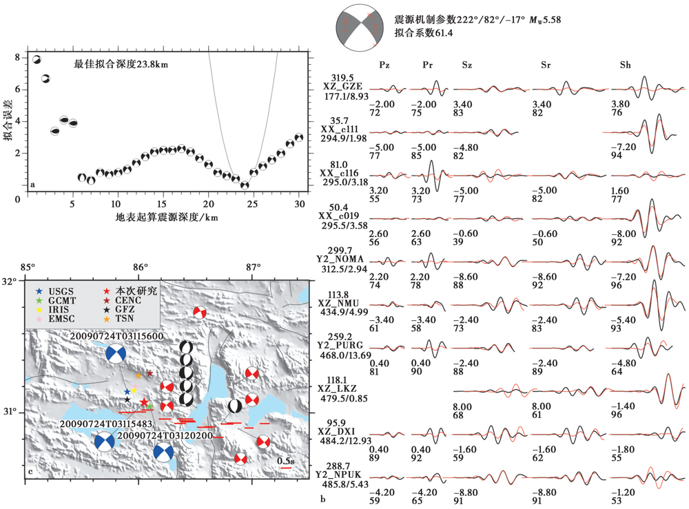
图4 CAP反演结果及当惹雍错裂谷地区的地震定位、 震源机制、 SKS研究对比 a CAP反演中的最佳震源深度结果; b CAP反演中理论地震图与观测地震图的拟合程度及震源机制解, 红色实线表示理论地震图, 黑色实线为观测地震图, 波形左侧为台站名, 台站名左下数字为震中距(单位: km), 右下数字为该台理论初至P波与观测初至P波的到时差, 上方值为方位角(°), 波形下方的2行数字分别代表理论地震图相对观测地震图的移动时间(单位: s)与两者的相关系数(%); c 当惹雍错地区(图1b中的黑色矩形区域)的地震定位及震源机制、 SKS横波分裂快慢波延时EW分量(引自Chen et al., 2015)对比图
Fig. 4 CAP inversion results, and contrast of seismic locations, focal mechanism solutions and SKS wave splitting in the Tangra-Yumco rift area.
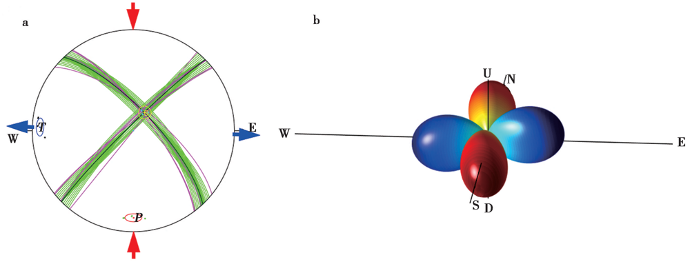
图5 a 中心震源机制解; b 空间三维辐射花样 a 红色箭头代表挤压, 蓝色箭头代表拉张, 红色圈部分代表主压力轴(P轴), 蓝色圈部分代表主拉张轴(T轴), 黄色圈部分代表中间主应力轴(B轴); b 红色代表挤压, 蓝色代表拉张
Fig. 5 Central focal mechanism(a)and its 3-D radiation pattern(b).
| 结果对比 | 节面Ⅰ | 节面Ⅱ | P轴 | T轴 | B轴 | |||||||
|---|---|---|---|---|---|---|---|---|---|---|---|---|
| 走向 | 倾向 | 滑动角 | 走向 | 倾向 | 滑动角 | 方位 | 俯角 | 方位 | 俯角 | 方位 | 俯角 | |
| 本文 | 222° | 82° | -17° | 314° | 73° | -171° | 177° | 17° | 269° | 6° | 18° | 71° |
| GCMT | 226° | 83° | -16° | 318° | 74° | -172° | 181° | 14° | 273° | 6° | 22° | 72° |
| USGS | 231° | 84° | -14° | 323° | 76° | -174° | 186° | 14° | 277° | 6° | 28° | 74° |
| 中心解 | 226° | 83° | -16° | 318° | 74° | -172° | 181° | 16° | 273° | 6° | 22° | 73° |
表2 本文与GCMT、 USGS的震源机制解结果和中心震源机制解结果的对比
Table 2 Comparison of focal mechanism solution obtained by this study with that from GCMT, USGS, and the central focal mechanism solution
| 结果对比 | 节面Ⅰ | 节面Ⅱ | P轴 | T轴 | B轴 | |||||||
|---|---|---|---|---|---|---|---|---|---|---|---|---|
| 走向 | 倾向 | 滑动角 | 走向 | 倾向 | 滑动角 | 方位 | 俯角 | 方位 | 俯角 | 方位 | 俯角 | |
| 本文 | 222° | 82° | -17° | 314° | 73° | -171° | 177° | 17° | 269° | 6° | 18° | 71° |
| GCMT | 226° | 83° | -16° | 318° | 74° | -172° | 181° | 14° | 273° | 6° | 22° | 72° |
| USGS | 231° | 84° | -14° | 323° | 76° | -174° | 186° | 14° | 277° | 6° | 28° | 74° |
| 中心解 | 226° | 83° | -16° | 318° | 74° | -172° | 181° | 16° | 273° | 6° | 22° | 73° |
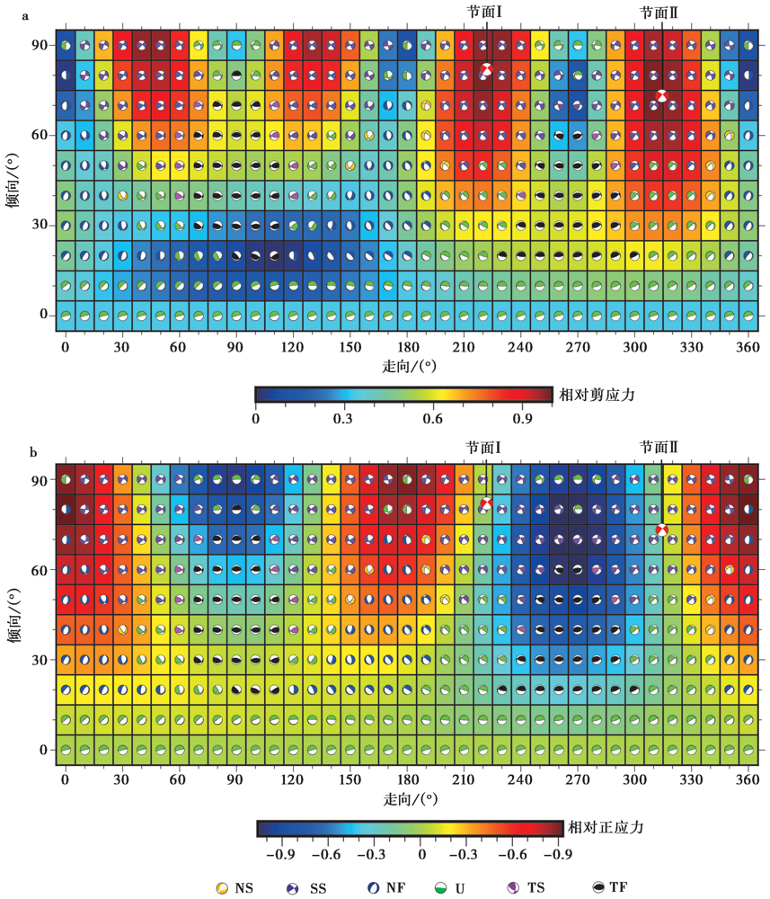
图6 区域应力场在不同断层面上的相对剪应力(a)和相对正应力(b) 震源机制解(图4)对应的应力场在对应走向和倾向产生的相对剪应力和相对正应力。 震源机制类型为: NS 正走滑型; SS 走滑型; NF 正断型; U 不确定型; TS 逆走滑型; TF 逆断型
Fig. 6 Relative shear stress(a)and relative normal stress(b)of regional stress field on various faults.
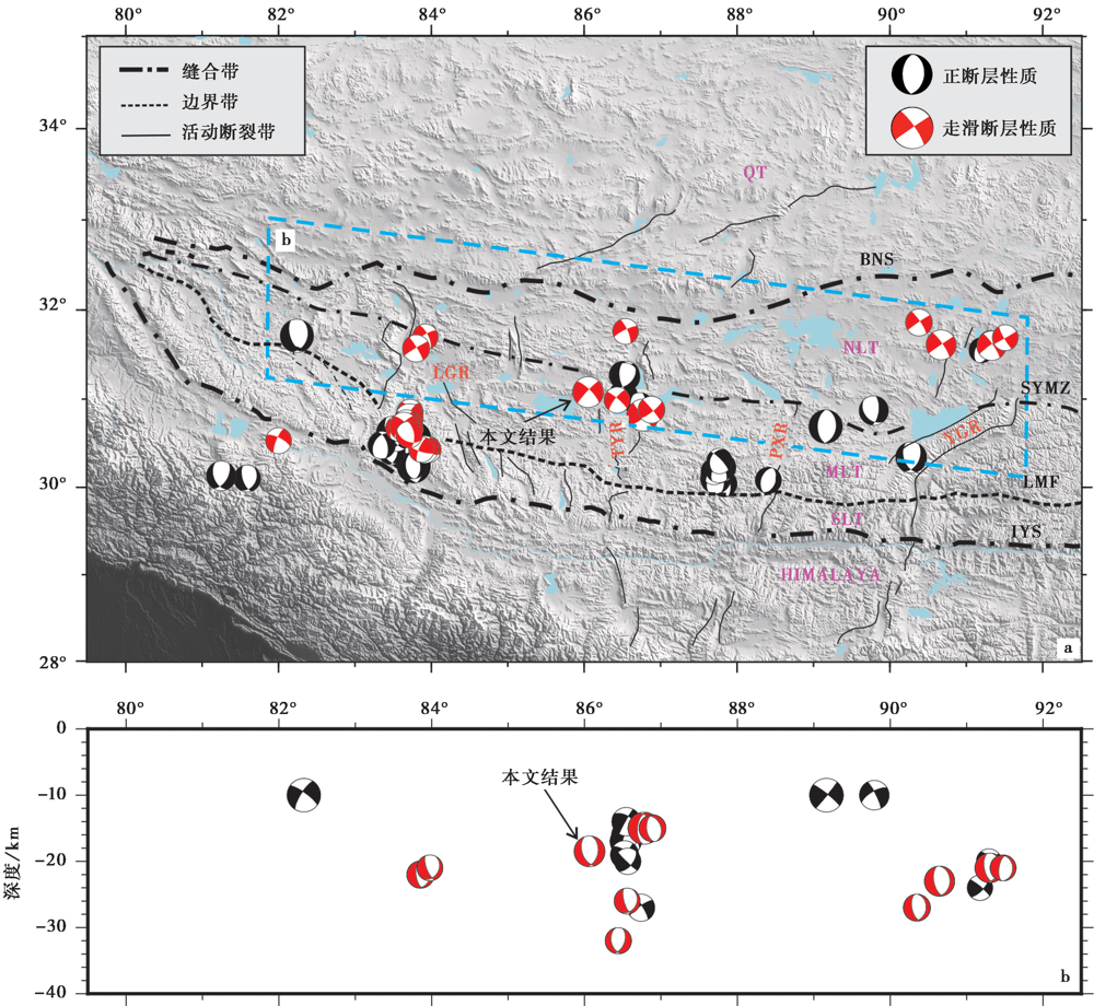
图7 拉萨地体内的震源机制解及其错动类型 a 拉萨地体内(30°~32°N, 79.5°~92.5°E)地震的震源机制解及其错动类型平面图, 震源数据见网页 (来自GCMT目录), 黑色震源球代表正断性质, 红色震源球代表走滑性质; b 拉萨地体内沿SYMZ(图7a中的蓝色区域)地震的震源机制解及其错动类型剖面图(投影至31°N)
Fig. 7 The focal mechanism solution and its dislocation type plan of the Lhasa terrane.
| [1] | 曹圣华, 李德威, 余忠珍, 等. 2009. 西藏冈底斯当惹雍错-许如错SN向地堑的特征及成因[J]. 地球科学(中国地质大学学报), 34(6): 914-920. |
| CAO Sheng-hua, LI De-wei, YU Zhong-zhen, et al. 2009. Characteristics and mechanism of the Dangra Yun Co and Xuru Co NS-trending graben in the Gangdese, Tibet[J]. Earth Science(Journal of China University of Geosciences), 34(6): 914-920. (in Chinese) | |
| [2] | 陈振华, 刘云, 李均良. 2006. 西藏当惹雍错吉松环斑花岗岩的发现及地质意义[J]. 沉积与特提斯地质, 26(2): 16-20. |
| CHEN Zhen-hua, LIU Yun, LI Jun-liang. 2006. The discovery and significance of the rapakivi granites in Gyisong, Tangra Yumco, Xizang[J]. Sedimentary Geology and Tethyan Geology, 26(2): 16-20. (in Chinese) | |
| [3] | 丁林, 岳雅慧, 蔡福龙, 等. 2006. 西藏拉萨地块高镁超钾质火山岩及对SN向裂谷形成时间和切割深度的制约[J]. 地质学报, 80(9): 1252-1261. |
| DING Lin, YUE Ya-hui, CAI Fu-long, et al. 2006. 40Ar/39Ar geochronology, geochemical and Sr-Nd-O isotopic characteristics of the high-Mg ultrapotassic rocks in Lhasa block of Tibet: Implications in the onset time and depth of NS-striking rift system[J]. Acta Geologica Sinica, 80(9): 1252-1261. (in Chinese) | |
| [4] | 管勇, 吴朋, 马付红. 2017. 地震台站空隙角对地震定位精度的影响[J]. 地震地磁观测与研究, 38(3): 53-59. |
| GUAN Yong, WU Peng, MA Fu-hong. 2017. The influence of the gap angle of the stations on the accuracy of different positioning methods[J]. Seismological and Geomagnetic Observation and Research, 38(3): 53-59. (in Chinese) | |
| [5] | 贺日政. 2003. 青藏高原近SN向裂谷的岩石圈结构及其动力学过程[D]. 北京: 中国地质科学院. |
| HE Ri-zheng. 2003. Lithospheric structure of near north-south striking rifts in Tibet Plateau and its geodynamical process[D]. Chinese Academy of Geological Sciences, Beijing. (in Chinese) | |
| [6] | 贺日政, 高锐, 郑洪伟. 2007a. 隐伏在青藏高原中部的EW走向断裂的航磁异常场特征及其意义[J]. 吉林大学学报(地球科学版), 37(5): 1002-1008. |
| HE Ri-zheng, GAO Rui, ZHENG Hong-wei. 2007a. Areomagnetic anomaly of subtle east-west striking faults in the central Tibet and its significance[J]. Journal of Jilin University(Earth Science Edition), 37(5): 1002-1008. (in Chinese) | |
| [7] | 贺日政, 高锐, 郑洪伟, 等. 2007b. 青藏高原中西部航磁异常的匹配滤波分析与构造意义[J]. 地球物理学报, 50(4): 1031-1040. |
| HE Ri-zheng, GAO Rui, ZHENG Hong-wei, et al. 2007b. Matched-filter analysis of aeromagnetic anomaly in mid-western Tibetan plateau and its tectonic implications[J]. Chinese Journal of Geophysics, 50(4): 1031-1040. (in Chinese) | |
| [8] | 李赫, 董一兵, 王熠熙, 等. 2020. 廊固凹陷深部剪切破裂构造的地震学证据[J]. 地球物理学报, 63(2): 492-504. |
| LI He, DONG Yi-bing, WANG Yi-xi, et al. 2020. Seismological evidence for a deep-seated shear zone in the Langgu Depression[J]. Chinese Journal of Geophysics, 63(2): 492-504. (in Chinese) | |
| [9] | 廖思平, 陈振华, 罗小川, 等. 2002. 西藏当惹雍错地区白榴石响岩的发现及地质意义[J]. 地质通报, 21(11): 735-738. |
| LIAO Si-ping, CHEN Zhen-hua, LUO Xiao-chuan, et al. 2002. Discovery of leucite phonolite in the Tangra Yumco area, Tibet and its geological significance[J]. Geological Bulietion of China, 21(11): 735-738. (in Chinese) | |
| [10] | 牛潇, 郑洪伟, 贺日政, 等. 2021. 青藏高原中部INDEPTH-Ⅲ剖面低速层研究[J]. 地球学报, 42(1): 74-84. |
| NIU Xiao, ZHENG Hong-wei, HE Ri-zheng, et al. 2021. A study of the low velocity layer along INDEPTH-III profile in central Tibetan plateau[J]. Acta Geoscientica Sinica, 42(1): 74-84. (in Chinese) | |
| [11] | 潘桂棠, 莫宣学, 侯增谦, 等. 2006. 冈底斯造山带的时空结构及演化[J]. 岩石学报, 22(3): 521-533. |
| PAN Gui-tang, MO Xuan-xue, HOU Zeng-qian, et al. 2006. Spatial-temporal framework of the Fangdese orogenic belt and its evolution[J]. Acta Petrologica Sinica, 22(3): 521-533. (in Chinese) | |
| [12] | 秦四清, 薛雷, 黄鑫, 等. 2010. 西藏地区未来强震预测[J]. 地球物理学进展, 25(6): 1879-1886. |
| QIN Si-qing, XUE Lei, HUANG Xin, et al. 2010. A forward prediction of strong earthquakes in the Tibet region[J]. Process in Geophysics, 25(6): 1879-1886. (in Chinese) | |
| [13] | 沈小七, 索仁, 王俊, 等. 2015. 2009年7月24日西藏尼玛西南 MS5.6 地震研究[J]. 地震工程学报, 31(1): 181-187. |
| SHEN Xiao-qi, SUO Ren, WANG Jun, et al. 2015. Research on the MS5.6 earthquake of July 24, 2009 in the southwest Nima, Tibet[J]. China Earthquake Engineering Journal, 31(1): 181-187. (in Chinese) | |
| [14] | 滕吉文, 宋鹏汉, 刘有山, 等. 2019. 青藏高原“亚东-东巧-葫芦湖”大陆裂谷带形成的深层动力过程[J]. 地球物理学报, 62(9): 3321-3339. |
| TENG Ji-wen, SONG Peng-han, LIU You-shan, et al. 2019. Deep dynamics for the Yadong-Dongqiao-Huluhu Rift in the Tibetan plateau[J]. Chinese Journal of Geophysics, 62(9): 3321-3339. (in Chinese) | |
| [15] | 万永革. 2016. 地震学导论[M]. 北京: 科学出版社. |
| WAN Yong-ge. 2016. Introduction to Seismology[M]. Science Press, Beijing. (in Chinese) | |
| [16] | 万永革. 2020. 震源机制与应力体系关系模拟研究[J]. 地球物理学报, 63(6): 2281-2296. |
| WAN Yong-ge. 2020. Simulation on relationship between stress regimes and focal mechanisms of earthquake[J]. Chinese Journal of Geophysics, 63(6): 2281-2296. (in Chinese) | |
| [17] | 王保弟, 刘函, 王立全, 等. 2020. 青藏高原狮泉河-拉果错-永珠-嘉黎蛇绿混杂岩带时空结构与构造演化[J]. 地球科学, 45(8): 34-54. |
| WANG Bao-di, LIU Han, WANG Li-quan, et al. 2020. Spatial-temporal framework of Shiquanhe-Laguoco-Yongzhu-Jiali ophiolite melange zone, Qinghai-Tibet Plateau and its tectonic evolution[J]. Earth Science, 45(8): 34-54. (in Chinese) | |
| [18] | 王亮. 2017. 裁剪-粘贴波形反演方法及其在地震学中的应用[D]. 桂林: 桂林理工大学. |
| WANG Liang. 2017. Cut and paste method and its application in seismology[D]. Guilin University of Technology, Gulin. (in Chinese) | |
| [19] | 王烁帆, 曾祥方, 王向腾, 等. 2019. 云南景谷地震震源深度: 新生断裂脆韧性转换带深度探讨[J]. 科学通报, 64(4): 474-484. |
| WANG Shuo-fan, ZENG Xiang-fang, WANG Xiang-teng, et al. 2019. Focal depth of the Yunnan Jinggu MW6.1 earthquake: Discussion on depth of the brittle-ductile transition zone of a young fault[J]. Chinese Science Bulletin, 64(4): 474-484. (in Chinese) | |
| [20] | 谢国刚. 2002. 邦多区幅H45C001002 1︰25万区域地质调查报告[R]. 江西省地质调查院. |
| XIE Guo-gang. 2002. 1/250000 regional geological survey report of Bangduo area H45C001002[R]. Geological Survey of Jiangxi Province. (in Chinese) | |
| [21] | 徐梦婧. 2014. 青藏高原狮泉河-永珠-嘉黎蛇绿混杂岩带的构造演化[D]. 长春: 吉林大学. |
| XU Meng-jing. 2014. The evolution of Shiquanhe-Yongzhu-Jiali ophiolitic melange belt, Tibetan plateau[D]. Jilin University, Changchun. (in Chinese) | |
| [22] | 闫永利, 马晓冰, 陈赟, 等. 2012. 西藏错勤-申扎剖面大地电磁测深研究[J]. 地球物理学报, 55(8): 2636-2642. |
| YAN Yong-li, MA Xiao-bing, CHEN Yun, et al. 2012. The study of magnetotelluric sounding on Coqen-Xainza profile in Tibet[J]. Chinese Journal of Geophysics, 55(8): 2636-2642. (in Chinese) | |
| [23] | 易桂喜, 龙锋, 梁明剑, 等. 2020. 四川盆地荣县-威远-资中地区发震构造几何结构与构造变形特征: 基于震源机制解的认识和启示[J]. 地球物理学报, 63(9): 3275-3291. |
| YI Gui-xi, LONG Feng, LIANG Ming-jian, et al. 2020. Geometry and tectonic deformation of seismogenic structures in the Rongxian-Weiyuan-Zizhong region, Sichuan Basin: Insights from focal mechanism solutions[J]. Chinese Journal of Geophysic, 63(9): 3275-3291. (in Chinese) | |
| [24] | 于丽芳, 赵文霞, 陈建林, 等. 2012. 西藏当惹雍错富钾和富钠碱性火山岩的矿物学研究及其成因指示[J]. 大地构造与成矿学, 36(2): 274-283. |
| YU Li-fang, ZHAO Wen-xia, CHEN Jian-lin, et al. 2012. Mineralogical characteristics of the sodium- and potassic-rich alkaline volcanic rocks at Tangra Yumco, SE Tibet: Implications for petrogenesis[J]. Geotectonica et Metallogenia, 36(2): 274-283. (in Chinese) | |
| [25] | 曾融生, 孙为国. 1992. 青藏高原及其邻区的地震活动性和震源机制以及高原物质东流的讨论[J]. 地震学报, 14(S1): 534-564. |
| ZENG Rong-sheng, SUN Wei-guo. 1992. Seismicity and focal mechanism in Tibetan plateau and its implications to lithospheric flow[J]. Acta Seismologica Sinca, 14(S1): 534-564. (in Chinese) | |
| [26] | 张国民, 李丽. 2003. 地壳介质的流变性与孕震模型[J]. 地震地质, 25(1): 1-10. |
| ZHANG Guo-min, LI Li. 2003. Rheology of crustal media and a related seismogenic model[J]. Seismology and Geology, 25(1): 1-10. (in Chinese) | |
| [27] |
张佳伟, 李汉敖, 张会平, 等. 2020. 青藏高原新生代SN走向裂谷研究进展[J]. 地球科学进展, 35(8): 848-862.
DOI |
| ZHANG Jia-wei, LI Han-ao, ZHANG Hui-ping, et al. 2020. Research progress in Cenozoic N-S striking rifts in Tibetan plateau[J]. Advinces in Earth Science, 35(8): 848-862. (in Chinese) | |
| [28] | 张进江, 丁林. 2003. 青藏高原EW向伸展及其地质意义[J]. 地质科学, 38(2): 179-189. |
| ZHANG Jin-jiang, DING Lin. 2003. East-west extension in Tibetan plateau and its significance to tectonic evolution[J]. Chinese Journal of Geology, 38(2): 179-189. (in Chinese) | |
| [29] | 赵志丹, 莫宣学, 罗照华, 等. 2003. 印度-亚洲俯冲带结构: 岩浆作用证据[J]. 地学前缘, 10(3): 149-157. |
| ZHAO Zhi-dan, MO Xuan-xue, LUO Zhao-hua, et al. 2003. Subduction of India beneath Tibet: Magamatism evidence[J]. Earth Science Frontiers, 10(3): 149-157. (in Chinese) | |
| [30] | 赵志丹, 莫宣学, Sebastien N, 等. 2006. 青藏高原拉萨地块碰撞后超钾质岩石的时空分布及其意义[J]. 岩石学报, 22(4): 787-794. |
| ZHAO Zhi-dan, MO Xuan-xue, Sebastien N, et al. 2006. Post-collisional ultrapotassic rocks in Lhasa Block, Tibetan plateau: Spatial and temporal distribution and its implications[J]. Acta Petrologica Sinica, 22(4): 787-794. (in Chinese) | |
| [31] | 郑斯华. 1995. 青藏高原地震的震源深度及其构造意义[J]. 中国地震, 11(2): 99-106. |
| ZHENG Si-hua. 1995. Focal depth of earthquakes under the Tibetan plateau and its tectonic implication[J]. Earthquake Research in China, 11(2): 99-106. (in Chinese) | |
| [32] | 郑秀芬, 欧阳飚, 张东宁, 等. 2009. “国家数字测震台网数据备份中心”技术系统建设及其对汶川大地震研究的数据支撑[J]. 地球物理学报, 52(2): 1412-1417. |
| ZHENG Xiu-fen, OUYANG Biao, ZHANG Dong-ning, et al. 2009. Technical system construction of Data Backup Centre for China Seismograph Network and the data support to researches on the Wenchuan earthquake[J]. Chinese Journal of Geophysics, 52(2): 1412-1417. (in Chinese) | |
| [33] | 朱弟成, 潘桂棠, 王立全, 等. 2008. 西藏冈底斯带中生代岩浆岩的时空分布和相关问题的讨论[J]. 地质通报, 27(9): 1535-1550. |
| ZHU Di-cheng, PAN Gui-tang, WANG Li-quan, et al. 2008. Tempo-spatial variations of Mesozoic magmatic rocks in the Gangdise Belt, Tibet, China, with a discussion of geodynamic setting-related issues[J]. Geological Bulletin of China, 27(9): 1535-1550. (in Chinese) | |
| [34] | 朱高华. 2016. 青藏高原中部拉涨构造地震活动性研究[D]. 北京: 中国科学院大学. |
| ZHU Gao-hua. 2016. Seismicity of the extensional tectonics in central Tibetan plateau[D]. University of Chinese Academy of Sciences, Beijing. (in Chinese) | |
| [35] | 邹长桥, 贺日政, 高锐, 等. 2012. 远震P波层析成像研究羌塘中央隆起带深部结构[J]. 科学通报, 57(28-29): 2729-2739. |
| ZOU Chang-qiao, HE Ri-zheng, GAO Rui, et al. 2012. Deep structure of the central uplift belt in the Qiangtang terrane, Tibetan plateau from teleseismic P-wave tomography[J]. Chinese Science Bulletin, 57(28-29): 2729-2739. (in Chinese) | |
| [36] | Armijo R, Tapponnier P, Mercier J L, et al. 1986. Quaternary extension in southern Tibet: Field observations and tectonic implications[J]. Journal of Geophysical Research: Solid Earth, 91(B14): 13803-13872. |
| [37] |
Barron J, Priestley K. 2009. Observations of frequency-dependent Sn propagation in northern Tibet[J]. Geophysical Journal International, 179(1): 475 https://doi.org/10.1111/j.1365-246X.2009.04318.x.
DOI URL |
| [38] |
Chen Y, Li W, Yuan X H, et al. 2015. Tearing of the Indian lithospheric slab beneath southern Tibet revealed by SKS-wave splitting measurements[J]. Earth and Planetary Science Letters, 413:13-24. http://dx.doi.org/10.1016/j.pngl.2014.12.041.
DOI URL |
| [39] |
Ding L. 2003. Cenozoic volcanism in Tibet: Evidence for a transition from oceanic to continental subduction[J]. Journal of Petrology, 44(10): 1833-1865.
DOI URL |
| [40] | Dong H, Wei W B, Jin S, et al. 2020. Shaping the surface deformation of central and south Tibetan plateau: Insights from magnetotelluric array data[J]. Journal of Geophysical Research: Solid Earth, 125(9): e019206. https://doi.org/10.1029/2019JB019206. |
| [41] | Ekström G, Nettles M, Dziewoński A M, et al. 2012. The global CMT project 2004-2010: Centroid-moment tensors for 13017 earthquakes[J]. Physics of the Earth and Planetary Interiors, 200-201:1-9. https://doi.org/10.1016/j.pepi.2012.04.002. |
| [42] | Engdahl E R, van de Hilst R D, Buland R P. 1998. Global teleseismic earthquake relocation with improved travel times and procedures for depth determination[J]. Bulletin of the Seismological Society of America, 88(3): 722-743. https://doi.org/10.1785/BSSA0880030722. |
| [43] | Gao S S, Liu K H. 2009. Significant seismic anisotropy beneath the southern Lhasa Terrane, Tibetan plateau[J]. Geochemistry, Geophysics, Geosystems, 10(2): 1-19. https://doi.org/10.1029/2008GC002227. |
| [44] | Geiger L. 1912. Probability method for determination of earthquake epicenters from arrival time only[J]. Bulletin of Saint Louis University, 8(1): 60-71. |
| [45] | Huang S H, Chen W, Chiao L. 2011. A data-adaptive, multiscale approach of finite-frequency, traveltime tomography with special reference to P and S wave data from central Tibet[J]. Journal of Geophysical Research: Solid Earth, 116(B6): B06307. https://doi.org/10.1029/2010JB008190. |
| [46] | Klein F W. 2002. User’s guide to HYPOINVERSE-2000, a Fortran program to solve for earthquake locations and magnitudes(4/2002 version)[R]. United States Department of the Interior Geological Survey, Open File Report 02-171. https://doi.org/10.13140/2.1.4859.3602. |
| [47] |
Li J T, Song X D. 2018. Tearing of Indian mantle lithosphere from high-resolution seismic images and its implications for lithosphere coupling in southern Tibet[J]. Proceedings of the National Academy of Sciences, 115(33): 8296-8300. https://doi.org/10.1073/pnas.1717258115.
DOI URL |
| [48] | Li Y L, Wang B S, He R Z, et al. 2018. Fine relocation, mechanism, and tectonic indications of middle-small earthquakes in the central Tibetan plateau[J]. Earth and Planetary Physics, 2(5): 1-14. http://doi.org/10.26464/epp2018038. |
| [49] |
Liang X F, Chen Y, Tian X B, et al. 2016. 3D imaging of subducting and fragmenting Indian continental lithosphere beneath southern and central Tibet using body-wave finite-frequency tomography[J]. Earth and Planetary Science Letters, 443(1): 162-175. https://doi.org/10.1016/j.pngl.2016.03.029.
DOI URL |
| [50] |
Lin T H, Lo C H, Chung S L, et al. 2009. 40Ar/39Ar dating of the Jiali and Gaoligong shear zones: Implications for crustal deformation around the eastern Himalayan syntaxis[J]. Journal of Asian Earth Sciences, 34(5): 674-685. https://doi.org/10.1016/j.jseaes.2008.10.009.
DOI URL |
| [51] |
Long F, Yi G X, Wang S W, et al. 2019. Geometry and tectonic deformation of the seismogenic structure for the 8 August 2017 MS7.0 Jiuzhaigou earthquake sequence, northern Sichuan, China[J]. Earth and Planetary Physics, 3(3): 253-267. http://doi.org/10.26464/epp2019027.
DOI URL |
| [52] |
Melbourne T, Carmichael I, Demets C, et al. 2013. The geodetic signature of the M8.0 Oct. 9, 1995, Jalisco subduction earthquake[J]. Geophysical Research Letters, 24(6): 715-718.
DOI URL |
| [53] | Molnar P, Tapponnier P. 1978. Active tectonics of Tibet[J]. Journal of Geophysical Research: Solid Earth, 83(B11): 5361-5375. |
| [54] |
Mori J. 1991. Estimates of velocity structure and source depth using multiple P waves from aftershocks of the 1987 Elmore Ranch and Superstition Hills, California, earthquakes[J]. Bulletin of the Seismological Society of America, 81(2): 508-523.
DOI URL |
| [55] | Mori J, Abercrombie R E. 1997. Depth dependence of earthquake frequency-magnitude distributions in California: Implications for rupture initiation[J]. Journal of Geophysical Research: Solid Earth, 102(B7): 15081-15090. |
| [56] |
Nunn C, Roecker S W, Priestley K F, et al. 2014. Joint inversion of surface waves and teleseismic body waves across the Tibetan collision zone: The fate of subducted Indian lithosphere[J]. Geophysical Journal International, 198(3): 1526-1542. https://doi.org/10.1093/gji/ggu193.
DOI URL |
| [57] |
Shang X F, de Hoop M V, van de Hilst R D. 2017. Common conversion point stacking of receiver functions versus passive-source reverse time migration and wavefield regularization[J]. Geophysical Journal International, 209(2): 923-934. https://doi.org/10.1093/gji/ggx069.
DOI URL |
| [58] |
Taylor M, Yin A. 2009. Active structures of the Himalayan-Tibetan orogen and their relationships to earthquake distribution, contemporary strain field, and Cenozoic volcanism[J]. Geosphere, 5(3): 199-214. https://doi.org/10.1130/GES00217.1.
DOI URL |
| [59] |
Wan Y G. 2010. Contemporary tectonic stress field in China[J]. Earthquake Science, 23(4): 377-386. https://doi.org/10.1007/s11589-010-0735-5.
DOI URL |
| [60] |
Wu C L, Tian X B, Xu T, et al. 2019. Upper-crustal anisotropy of the conjugate strike-slip fault zone in central Tibet analyzed using local earthquakes and shear-wave splitting[J]. Bulletin of the Seismological Society of America, 109(5): 1968-1984. https://doi.org/10.1785/0120180333.
DOI URL |
| [61] |
Xu Q, Zhao J M, Yuan X H, et al. 2015. Mapping crustal structure beneath southern Tibet: Seismic evidence for continental crustal underthrusting[J]. Gondwana Research, 27(4): 1487-1493. https://doi.org/10.1016/j.gr.2014.01.006.
DOI URL |
| [62] | Xue S, Chen Y, Liang H D, et al. 2021. Deep electrical resistivity structure across the Gyaring Co Fault in central Tibet revealed by magnetotelluric data and its implication[J]. Tectonophysics, 809(20): 228835. https://doi.org/10.1016/j.tecto.2021.228835. |
| [63] |
Yin A, Harrison T M. 2000. Geologic evolution of the Himalayan-Tibetan orogen[J]. Annual Review of Earth and Planetary Sciences, 28: 211-280.
DOI URL |
| [64] |
Zheng X F, Yao Z X, Liang J H, et al. 2010. The role played and opportunities provided by IGP DMC of China National Seismic Network in Wenchuan earthquake disaster relief and researches[J]. Bulletin of the Seismological Society of America, 100(5B): 2866-2872. http://dx.doi.org/10.1785/0120090257.
DOI URL |
| [65] |
Zhu D C, Mo X X, Zhao Z D, et al. 2010. Presence of Permian extension- and arc-type magmatism in southern Tibet: Paleogeographic implications[J]. Geological Society of America Bulletin, 122(7-8): 979-993. https://doi.org/10.1130/B30062.1.
DOI URL |
| [66] |
Zhu D C, Zhao Z D, Niu Y L, et al. 2013. The origin and pre-Cenozoic evolution of the Tibetan plateau[J]. Gondwana Research, 23(4): 1429-1454. https://doi.org/10.1016/j.gr.2012.02.002.
DOI URL |
| [67] |
Zhu D C, Zhao Z D, Pan G T, et al. 2009. Early Cretaceous subduction-related adakite-like rocks of the Gangdese Belt, southern Tibet: Products of slab melting and subsequent melt-peridotite interaction?[J]. Journal of Asian Earth Sciences, 34(3): 298-309. https://doi.org/10.1016/j.jseaes.2008.05.003.
DOI URL |
| [68] |
Zhu G H, Liang X F, Tian X B, et al. 2017. Analysis of the seismicity in central Tibet based on the SANDWICH network and its tectonic implications[J]. Tectonophysics, 702(4): 1-7.
DOI URL |
| [69] |
Zhu L P, Ben-Zion Y. 2013. Parametrization of general seismic potency and moment tensors for source inversion of seismic waveform data[J]. Geophysical Journal International, 194(2): 839-843. https://doi.org/10.1093/gji/ggt137.
DOI URL |
| [70] |
Zhu L P, Helmberger D V. 1996. Advancement in source estimation techniques using broadband regional seismograms[J]. Bulletin of the Seismological Society of America, 86(5): 1634-1641.
DOI URL |
| [1] | 李岩, 陈俊磊, 吕思宇, 王宇栋, 傅磊. 景谷地震序列触发关系及应力场反演[J]. 地震地质, 2026, 48(2): 561-581. |
| [2] | 常金龙, 甘卫军, 周晨, 朱成林, 刘长生, 姚程越. 依兰-伊通断裂北段应变状态及发震机制讨论[J]. 地震地质, 2026, 48(1): 200-216. |
| [3] | 王霞, 宋美卿, 吴昊昱, 梁向军, 吕睿, 郭文峰, 张娜, 李金. 山西裂谷构造应力场特征及其动力学意义[J]. 地震地质, 2026, 48(1): 257-277. |
| [4] | 黄婷, 吴芳, 夏彩香, 李振宏, 董晓朋, 吴中海, 寇琳琳. 宁夏清水河盆地南部全新世灾变事件层特征及其与区域地震的关系[J]. 地震地质, 2025, 47(4): 1036-1057. |
| [5] | 唐茂云, 李翠平, 黄世源, 董蕾, 高见, 李勇. 泸县—荣昌地区地震活动时空演化与构造应力场特征[J]. 地震地质, 2025, 47(4): 1183-1203. |
| [6] | 董春丽, 郭文峰, 刘瑞春, 丁大业. 山西中南部中小地震震源机制应力特征和地震活动相关性分析[J]. 地震地质, 2025, 47(4): 1222-1243. |
| [7] | 杨九元, 温扬茂, 许才军, 杨见兵. 同震及震后形变约束的2020年3月青藏高原南部定日 MW5.7 地震发震构造[J]. 地震地质, 2025, 47(4): 1292-1305. |
| [8] | 郭钊吾, 鲁人齐, 张金玉, 房立华, 刘冠伸, 吴熙彦, 孙晓, 祁诗淼. 2025年1月7日西藏定日MS6.8强震发震断层三维模型与地震构造环境[J]. 地震地质, 2025, 47(3): 671-688. |
| [9] | 王度, 陈立春, 李彦宝, 王虎, 贾永顺, 高茵怡, 薛柯依. 藏南申扎-定结裂谷系谢通门-登么错段晚第四纪活动特征[J]. 地震地质, 2025, 47(3): 718-733. |
| [10] | 许月怡, 徐贝贝, 徐晨雨, 邵志刚, 胡朝忠. 基于远震P波、 强震波形和InSAR联合反演2025年西藏定日MS6.8地震破裂过程[J]. 地震地质, 2025, 47(3): 734-746. |
| [11] | 王鹏, 戴宗辉, 孔雪, 李铂, 徐长朋, 张梦昕. 西藏定日 MS6.8 地震序列应力场演化特征分析[J]. 地震地质, 2025, 47(3): 881-896. |
| [12] | 李金, 邓明文, 张治广, 孙业君, 姚远, 徐凯驰. 2024年塔里木盆地尉犁5级震群发震构造[J]. 地震地质, 2025, 47(2): 463-487. |
| [13] | 崔华伟, 尹昕忠, 陈九辉, 郭飚, 李涛, 姚远, 李世莹, 贾震. 帕米尔高原东北部地震活动及构造应力场特征[J]. 地震地质, 2025, 47(2): 577-596. |
| [14] | 盛书中, 王倩茹, 李振月, 李红星, 张小娟, 葛坤朋, 宫猛. 基于构造应力场研究2025年西藏定日6.8级地震的发震构造[J]. 地震地质, 2025, 47(1): 49-63. |
| [15] | 王鑫, 张珂, 王玥. 内蒙古阿鲁科尔沁旗MS5.9与MS4.7地震序列特征及其发震构造分析[J]. 地震地质, 2024, 46(6): 1314-1331. |
| 阅读次数 | ||||||
|
全文 |
|
|||||
|
摘要 |
|
|||||
