
SEISMOLOGY AND GEOLOGY ›› 2022, Vol. 44 ›› Issue (1): 256-278.DOI: 10.3969/j.issn.0253-4967.2022.01.016
• Special topic on the Qinghai Menyuan MS6.9 earthquake • Previous Articles
SURFACE RUPTURE CHARACTERISTICS OF THE MENYUAN MS6.9 EARTHQUAKE ON JANUARY 8, 2022, QINGHAI PROVINCE
LIANG Kuan1)( ), HE Zhong-tai1),2),3),*(), JIANG Wen-liang1), LI Yong-sheng1), LIU Ze-min1)
- 1) National Institute of Natural Hazards, Ministry of Emergency Management of China, Beijing 100085, China
2) Hebei Key Laboratory of Earthquake Dynamics, Institute of Disaster Prevention, Sanhe, Hebei 065201, China
3) Key Laboratory of Crustal Dynamics, China Earthquake Administration, Beijing 100085, China
-
Received:2022-01-25Revised:2022-02-22Online:2022-02-20Published:2022-04-20 -
Contact:HE Zhong-tai
2022年1月8日青海门源MS6.9地震的同震地表破裂特征
梁宽1)(), 何仲太1),2),3),*(), 姜文亮1), 李永生1), 刘泽民1)
- 1)应急管理部国家自然灾害防治研究院, 北京 100085
2)防灾科技学院, 河北省地震动力学重点实验室, 三河 065201
3)中国地震局地壳动力学重点实验室, 北京 100085
-
通讯作者:何仲太 -
作者简介:梁宽, 男, 1988年生, 2019年于中国地震局地质研究所获构造地质学专业博士学位, 助理研究员, 研究方向为活动构造与构造地貌, E-mail: liangkuan18@126.com。 -
基金资助:应急管理部国家自然灾害防治研究院基本科研业务专项(ZDJ2019-28);应急管理部国家自然灾害防治研究院基本科研业务专项(ZDJ2019-21);国家自然科学基金(41872227);国家自然科学基金(41602221);高分遥感地震监测与应急应用示范系统(二期)川滇地区高分活动构造与风险排查示范项目(31-Y30F09-9001-20/22-6)
CLC Number:
Cite this article
LIANG Kuan, HE Zhong-tai, JIANG Wen-liang, LI Yong-sheng, LIU Ze-min. SURFACE RUPTURE CHARACTERISTICS OF THE MENYUAN MS6.9 EARTHQUAKE ON JANUARY 8, 2022, QINGHAI PROVINCE[J]. SEISMOLOGY AND GEOLOGY, 2022, 44(1): 256-278.
梁宽, 何仲太, 姜文亮, 李永生, 刘泽民. 2022年1月8日青海门源MS6.9地震的同震地表破裂特征[J]. 地震地质, 2022, 44(1): 256-278.
share this article
Add to citation manager EndNote|Ris|BibTeX
URL: https://www.dzdz.ac.cn/EN/10.3969/j.issn.0253-4967.2022.01.016
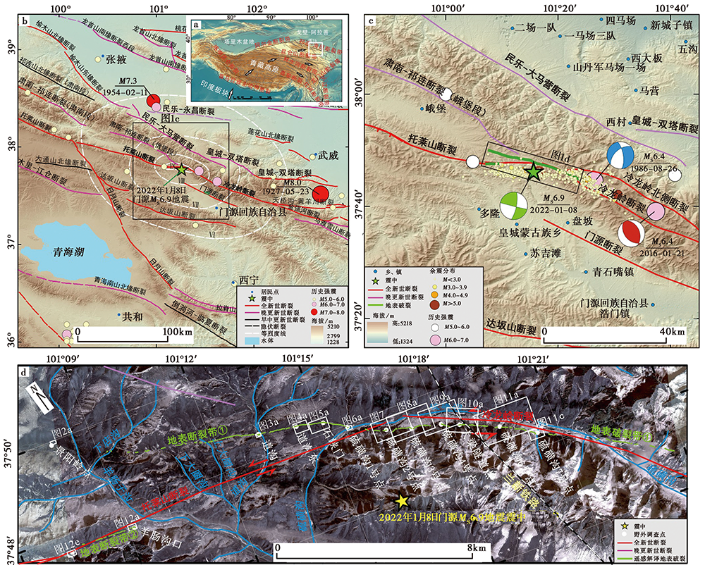
Fig. 1 Sketch map of active structure in the study area.
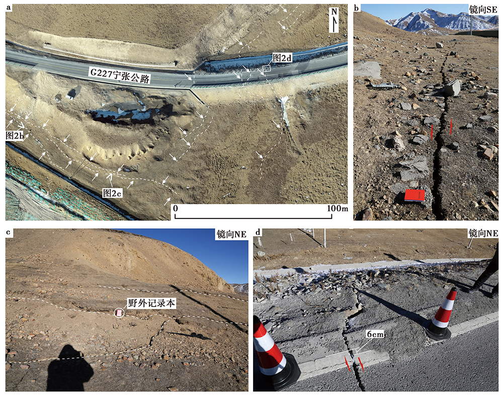
Fig. 2 Surface rupture of Jingyangling site.
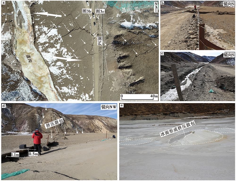
Fig. 3 Faulted landform in Daogou site.
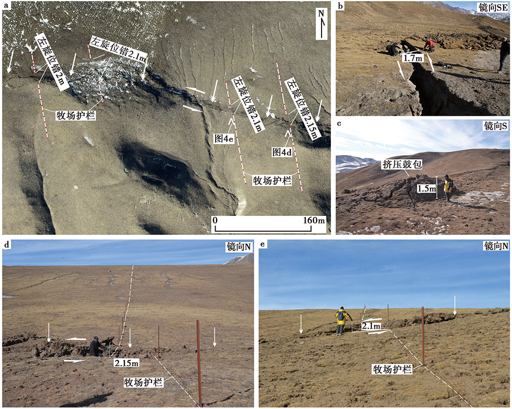
Fig. 4 Surface rupture of the east Daogou site.
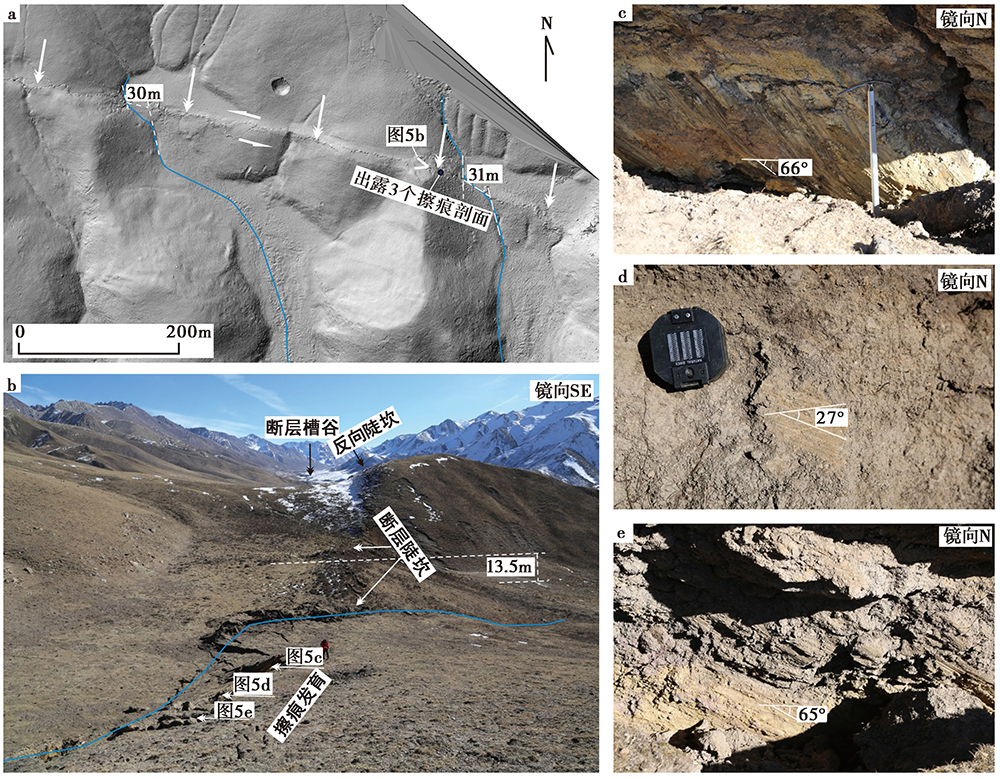
Fig. 5 Surface rupture and faulted landform of the Shixiamen site.
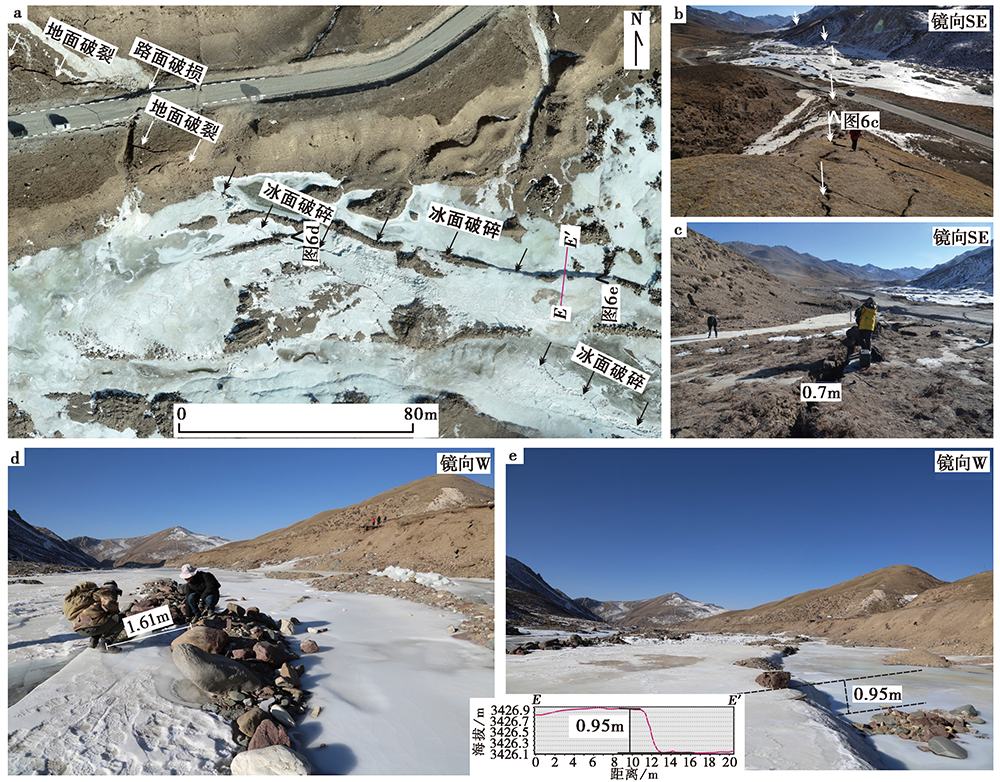
Fig. 6 Surface rupture of the Liuhuanggou No.1 site.
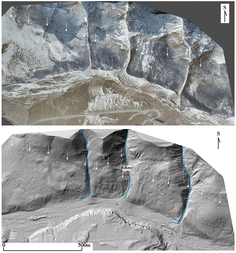
Fig. 7 DOM and DSM of the surface rupture in the Liuhuanggou No.2 site.
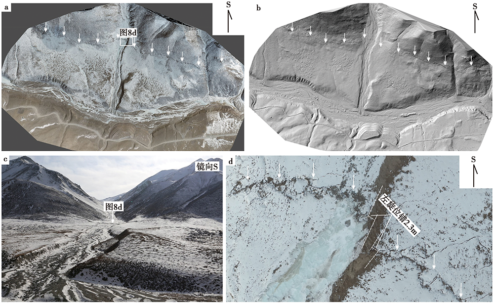
Fig. 8 Surface rupture of the Liuhuanggou No.3 site.
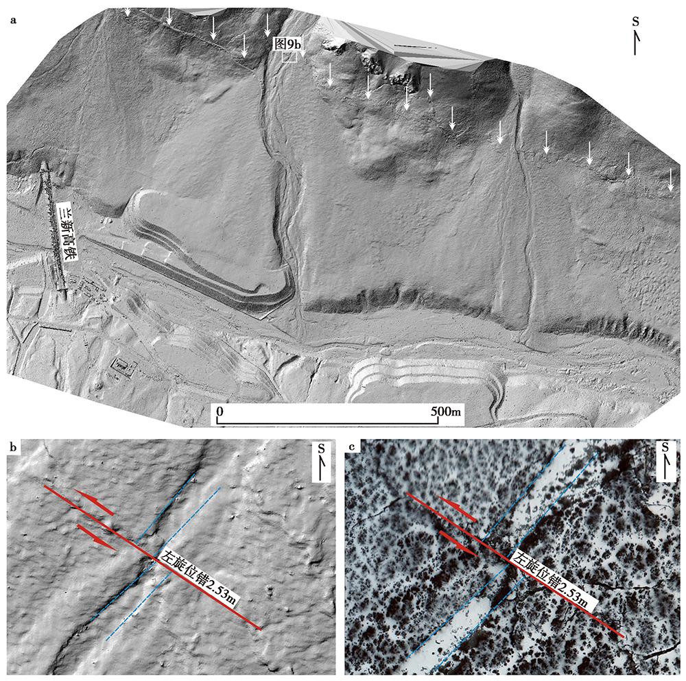
Fig. 9 Surface rupture of the Liuhuanggou No.4 site.
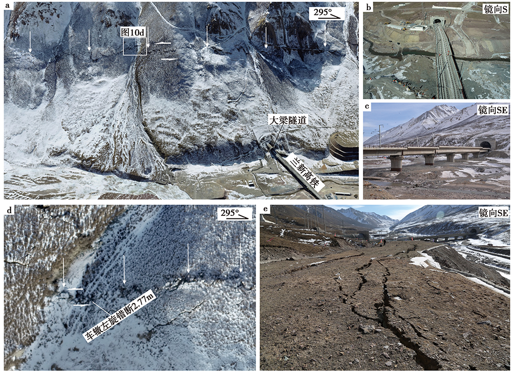
Fig. 10 Faulted landform of the Daliang tunnel site.
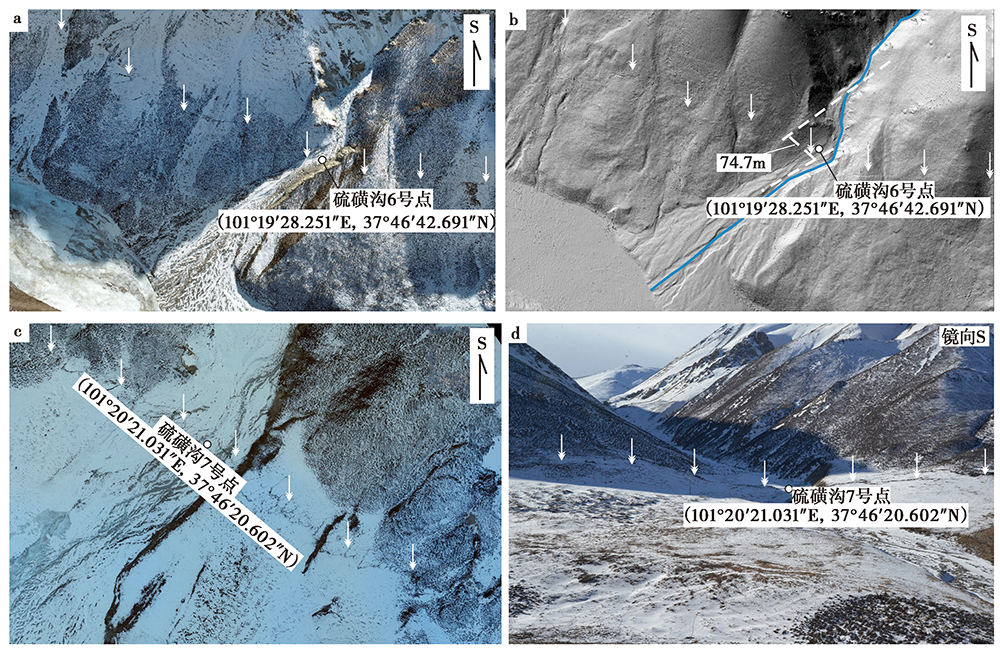
Fig. 11 Photos of the surface rupture in the Liuhuanggou No. 6 and 7 sites.
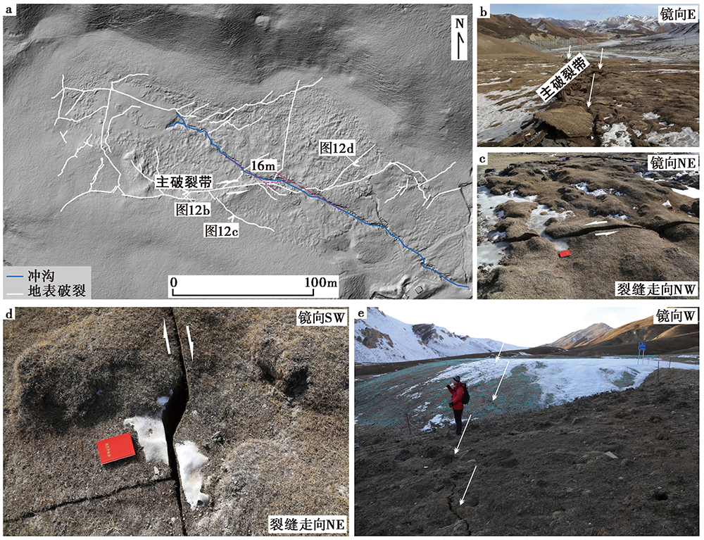
Fig. 12 Surface rupture of the Yangchangzigoukou site.
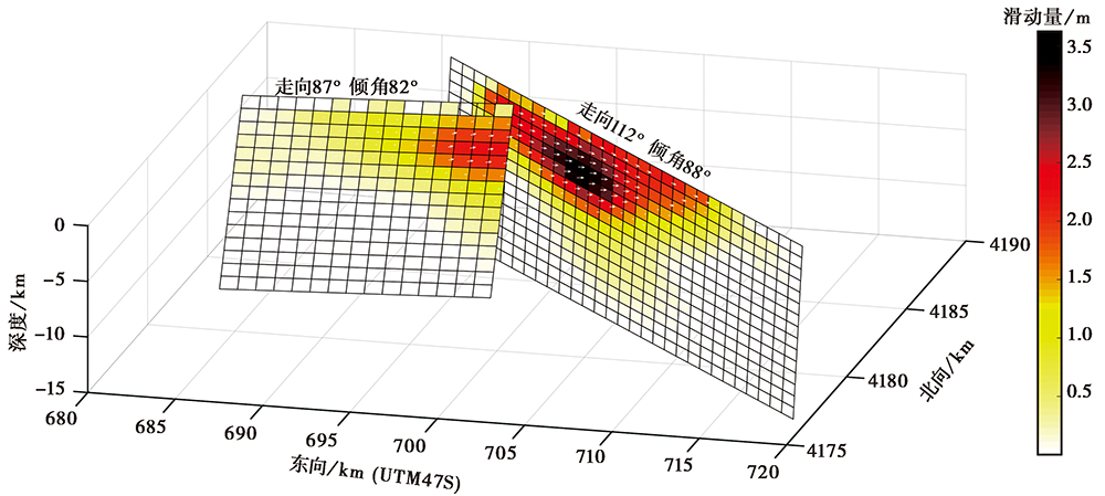
Fig. 13 InSAR inversion of fault rupture model of Menyuan MS6.9 earthquake in 2020.
| 东经 | 北纬 | 震源机制解 | 震源深度/km | 震级/MW | 数据来源 |
|---|---|---|---|---|---|
| 101.28° | 37.812° | F1:112°/88°/-4° F2:87°/82°/6° | 4.0 | 6.66 | InSAR(本文) |
| F1:104°/80°/0° F2:109°/80°/5° | 5.0 | 6.7 | InSAR(李振洪等, | ||
| 101.26° | 37.77° | 109°/81°/39° | 4.0 | 6.6 | IG, CEA |
| 101.31° | 37.80° | 104°/82°/1° | 14.8 | 6.7 | GCMT |
| 101.278° | 37.815° | 104°/88°/15° | 11.5 | 6.61 | USGS |
Table 1 Focal mechanism solutions and fault parameters
| 东经 | 北纬 | 震源机制解 | 震源深度/km | 震级/MW | 数据来源 |
|---|---|---|---|---|---|
| 101.28° | 37.812° | F1:112°/88°/-4° F2:87°/82°/6° | 4.0 | 6.66 | InSAR(本文) |
| F1:104°/80°/0° F2:109°/80°/5° | 5.0 | 6.7 | InSAR(李振洪等, | ||
| 101.26° | 37.77° | 109°/81°/39° | 4.0 | 6.6 | IG, CEA |
| 101.31° | 37.80° | 104°/82°/1° | 14.8 | 6.7 | GCMT |
| 101.278° | 37.815° | 104°/88°/15° | 11.5 | 6.61 | USGS |
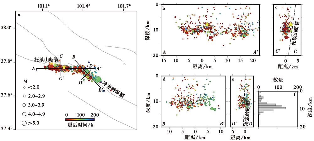
Fig. 14 Aftershocks distribution map.
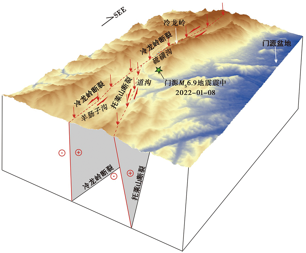
Fig. 15 Seismogenic structure map of Menyuan MS6.9 earthquake.
| [1] | 邓起东, 冉勇康, 杨晓平, 等. 2007. 中国活动构造图[CM]. 北京: 地震出版社. |
| DENG Qi-dong, RAN Yong-kang, YANG Xiao-ping, et al. 2007. Active Tectonic Map of China[M]. Seismological Press, Beijing. (in Chinese) | |
| [2] |
郭鹏, 韩竹军, 姜文亮, 等. 2017. 青藏高原东北缘冷龙岭断裂全新世左旋滑动速率[J]. 地震地质, 39(2): 323-341. doi: 10.3969/j.issn.0253-4967.2017.02.005.
DOI |
| GUO Peng, HAN Zhun-jun, JIANG Wen-liang, et al. 2017. Holocene left-lateral slip rate of the Lenglongling Fault, northeastern margin of the Tibetan plateau[J]. Seismology and Geology, 39(2): 323-341. (in Chinese) | |
| [3] | 何文贵, 刘百篪, 袁道阳, 等. 2000. 冷龙岭活动断裂的滑动速率研究[J]. 西北地震学报, 22(1): 90-97. |
| HE Wen-gui, LIU Bai-chi, YUAN Dao-yang, et al. 2000. Research on the slip rate of the Lenglongling fault zone[J]. Northwestern Seismological Journal, 22(1): 90-97. (in Chinese) | |
| [4] | 何文贵, 刘百箎, 袁道阳. 2001. 冷龙岭断裂古地震初步研究[G]// 《活动断裂研究》编委会. 活动断裂研究(8). 北京: 地震出版社: 64-74. |
| HE Wen-gui, LIU Bai-chi, YUAN Dao-yang. 2001. Preliminary study of the paleoearthquake on Lenglongling Fault[G]// Editorial Board of Research on Active Faults. Research of Active Fault (8). Seismological Press, Beijing: 64-74. (in Chinese) | |
| [5] | 何文贵, 袁道阳, 葛伟鹏, 等. 2010. 祁连山活动断裂带中东段冷龙岭断裂滑动速率的精确厘定[J]. 地震, 30(1): 131-137. |
| HE Wen-gui, YUAN Dao-yang, GE Wei-peng, et al. 2010. Determination of the slip rate of the Lenglongling Fault in the middle and eastern segments of the Qilian Mountain active fault zone[J]. Earthquake, 30(1): 131-137. (in Chinese) | |
| [6] | 胡朝忠, 杨攀新, 李智敏, 等. 2016. 2016年1月21日青海门源6.4级地震的发震机制探讨[J]. 地球物理学报, 59(5): 1637-1646. |
| HU Chao-zhong, YANG Pan-xin, LI Zhi-min, et al. 2016. Seismogenic mechanism of the 21 January 2016 Menyuan, Qinghai MS6.4 earthquake[J]. Chinese Journal of Geophysics, 59(5): 1637-1646. (in Chinese) | |
| [7] | 黄浩, 付虹. 2019. 2015年11月23日祁连5.2级地震发震构造初步研究[J]. 地震, 39(1): 114-125. |
| HUANG Hao, FU Hong. 2019. A preliminary study of the seismogenic structure of the Nov.23, 2015 Qilian 5.2 earthquake[J]. Earthquake, 39(1): 114-125. (in Chinese) | |
| [8] |
姜文亮, 李永生, 田云锋, 等. 2017. 冷龙岭地区2016年青海门源6.4级地震发震构造特征[J]. 地震地质, 39(3): 536-549. doi: 10.3969/j.issn.0253-4967.2017.03.007.
DOI |
| JIANG Wen-liang, LI Yong-sheng, TIAN Yun-feng, et al. 2017. Research of seismogenic structure of the Menyuan MS6.4 earthquake on January 21, 2016 in Lenglongling area of NE Tibetan plateau[J]. Seismology and Geology, 39(3): 536-549. (in Chinese) | |
| [9] | 李强, 江在森, 武艳强, 等. 2013. 海原-六盘山断裂带现今构造变形特征[J]. 大地测量与地球动力学, 33(2): 18-22. |
| LI Qiang, JIANG Zai-sen, WU Yan-qiang, et al. 2013. Present-day tectonic deformation characteristics of Haiyuan-Liupanshan fault zone[J]. Journal of Geodesy and Geodynamic, 33(2): 18-22. (in Chinese) | |
| [10] |
李振洪, 韩炳权, 刘振江, 等. 2022. InSAR数据约束下的2016年和2022年青海门源地震震源参数及其滑动分布[J]. 武汉大学学报信息科学版. doi: 10.13203/j.whugis20220037.
DOI |
| LI Zhen-hong, HAN Bing-quan, LIU Zhen-jiang, et al. 2022. Source parameters and slip distributions of the 2016 and 2022 Menyuan, Qinghai earthquakes constrained by InSAR observations[J]. Geomatics and Information Science of Wuhan University. (in Chinese) | |
| [11] | 汪进, 秦保燕, 董奇珍. 1992. 1986年8月26日门源6.4级地震破裂过程研究[J]. 华北地震科学, 10(2): 25-33. |
| WANG Jin, QIN Bao-yan, DONG Qi-zhen. 1992. A study on the fracture process of the Menyuan M6.4 earthquake occurred on August 26, 1986[J]. North China Earthquake Sciences, 10(2): 25-33. (in Chinese) | |
| [12] | 徐纪人, 姚立珣, 汪进. 1986. 1986年8月26日门源6.4级地震及其强余震的震源机制解[J]. 西北地震学报, 8(4): 82-84. |
| XU Ji-ren, YAO Li-xun, WANG Jin. 1986. Earthquake source mechanisms of Menyuan earthquake( MS6.4, on Aug. 26, 1986)and its strong aftershocks[J]. Northwestern Seismological Journal, 8(4): 82-84. (in Chinese) | |
| [13] | 徐锡伟, 韩竹军, 杨晓平, 等. 2016. 中国及邻近地区地震构造图[CM]. 北京: 地震出版社. |
| XU Xi-wei, HAN Zhu-jun, YANG Xiao-ping, et al. 2016. Seismotectonic Map of China and Adjacent Areas[CM]. Seismological Press, Beijing. (in Chinese) | |
| [14] |
徐锡伟, 吴熙彦, 于贵华, 等. 2017. 中国大陆高震级地震危险区判定的地震地质学标志及其应用[J]. 地震地质, 39(2): 219-275. doi: 10.3969/j.issn.0253-4967.2017.02.001.
DOI |
| XU Xi-wei, WU Xi-yan, YU Gui-hua, et al. 2017. Seismo-geological signatures for identifying M≥7.0 earthquake risk areas and their premilimary application in mainland China[J]. Seismology and Geology, 39(2): 219-275. (in Chinese) | |
| [15] | 杨丽萍, 苏旭. 2017. 德令哈市地震小区划[M]. 北京: 地震出版社. |
| YANG Li-ping, SU Xu. 2017. Seismic Microzonation of Delingha[M]. Seismological Press, Beijing. (in Chinese) | |
| [16] | 袁道阳, 刘百篪, 吕太乙, 等. 1998. 北祁连山东段活动断裂带的分段性研究[J]. 西北地震学报, 20(4): 27-34. |
| YUAN Dao-yang, LIU Bai-chi, LÜ Tai-yi, et al. 1998. Study on the segmentation in east segment of the northern Qilianshan fault zone[J]. North China Earthquake Sciences, 20(4): 27-34. (in Chinese) | |
| [17] | 袁道阳, 张培震, 刘百篪, 等. 2004. 青藏高原东北缘晚第四纪活动构造的几何图像与构造转换[J]. 地质学报, 78(2): 270-278. |
| YUAN Dao-yang, ZHANG Pei-zhen, LIU Bai-chi, et al. 2004. Geometrical imagery and tectonic transformation of the late Quaternary active tectonics in northeast margin of Qinghai-Xizang plateau[J]. Acta Geologica Sinica, 78(2): 270-278. (in Chinese) | |
| [18] | 张维歧, 焦德成, 柴炽章, 等. 2015. 天景山活动断裂带[M]. 北京: 地震出版社. |
| ZHANG Wei-qi, JIAO De-cheng, CHAI Chi-zhang, et al. 2015. The Tianjingshan Active Fault Zone[M]. Seismological Press, Beijing. (in Chinese) | |
| [19] | 郑文俊, 袁道阳, 何文贵. 2004. 祁连山东段天桥沟-黄羊川断裂古地震活动习性研究[J]. 地震地质, 26(4): 645-657. |
| ZHENG Wen-jun, YUAN Dao-yang, HE Wen-gui. 2004. Characteristics of paleoearthquake activity along the active Tianqiaogou-Huangyangchuan Fault on the eastern section of the Qilianshan Mountains[J]. Seismology and Geology, 26(4): 645-657. (in Chinese) | |
| [20] |
Allen M B, Walters R J, Song S, et al. 2017. Partitioning of oblique convergence coupled to the fault locking behavior of fold-and-thrust belts: Evidence from the Qilian Shan, northeastern Tibetan plateau[J]. Tectonics, 36(9-10): 1679-1698.
DOI URL |
| [21] | Fan L P, Li B R, Liao S R, et al. 2022. Precise relocation of the aftershock sequences of the 2022 M6.9 Menyuan earthquake[J]. Earthquake Science, 35(3): Q20220008. |
| [22] |
Gaudemer Y, Tapponnier P, Meyer B, et al. 1995. Partitioning of crustal slip between linked, active faults in the eastern Qilian Shan, and evidence for a major seismic gap, the ‘Tianzhu gap’, on the western Haiyuan Fault, Gansu(China)[J]. Geophysical Journal International, 120(3): 599-645.
DOI URL |
| [23] |
Guo P, Han Z J, An Y F, et al. 2017. Activity of the Lenglongling fault system and seismotectonics of the 2016 MS6.4 Menyuan earthquake[J]. Science China Earth Sciences, 60(5): 929-942.
DOI URL |
| [24] | Guo P, Han Z, Gao F, et al. 2020. A new tectonic model for the 1927 M8.0 Gulang earthquake on the NE Tibetan plateau[J]. Tectonics, 39: e2020TC006064. https://doi.org/10.1029/2020TC006064. |
| [25] |
Guo P, Han Z, Mao Z, et al. 2019. Paleoearthquakes and rupture behavior of the Lenglongling Fault: Implications for seismic hazards of the northeastern margin of the Tibetan plateau[J]. Journal of Geophysical Research: Solid Earth, 124:1520-1543.
DOI URL |
| [26] |
Hu X, Pan B, Kirby E, et al. 2015. Rates and kinematics of active shortening along the eastern Qilian Shan, China, inferred from deformed fluvial terraces[J]. Tectonics, 34:2478-2493.
DOI URL |
| [27] |
Jiang W L, Jiao Q S, Tian T, et al. 2021. Seismic slip distribution and rupture model of the Lenglongling fault zone, northeastern Tibetan plateau[J]. Geological Journal, 56(3): 1299-1314.
DOI URL |
| [28] | Lasserre C, Gaudemer Y, Tapponnier P, et al. 2002. Fast late Pleistocene slip rate on the Leng Long Ling segment of the Haiyuan Fault, Qinghai, China[J]. Journal of Geophysical Research: Solid Earth, 107(B11): 2276. |
| [29] |
Liu-Zeng J, Klinger Y, Xu X W, et al. 2007. Millennial recurrence of large earthquakes on the Haiyuan Fault near Songshan, Gansu Province, China[J]. Bulletin of the Seismological Society of America, 97(1B): 1-21.
DOI URL |
| [30] |
Meyer B, Tapponnier P, Bourjot L, et al. 1998. Crustal thickening in Gansu-Qinghai, lithospheric mantle subduction, and oblique, strike-slip controlled growth of the Tibet plateau[J]. Geophysical Journal International, 135(1): 1-47.
DOI URL |
| [31] |
Peltzer G, Tapponnier P. 1988. Formation and evolution of strike-slip faults, rifts, and basins during the India-Asia Collision: An experimental approach[J]. Journal of Geophysical Research, 93(B12): 15085-15117.
DOI URL |
| [32] |
Tapponnier P, Xu Z Q, Roger F, et al. 2001. Oblique stepwise rise and growth of the Tibet plateau[J]. Science, 294(5547): 1671-1677.
PMID |
| [33] | Wells D, Coppersmith K. 1994. New empirical relations among magnitude, rupture length, rupture width, rupture area and surface displacement[J]. Bulletin of the Seismological Society of America, 84(4): 974-l002. |
| [34] |
Xiong J, Li Y, Zhong Y, et al. 2017. Latest Pleistocene to Holocene thrusting recorded by a flight of strath terraces in the eastern Qilian Shan, NE Tibetan plateau[J]. Tectonics, 36:2973-2986.
DOI URL |
| [35] |
Xu X, Yeats R S, Yu G. 2010. Five short historical earthquake surface ruptures near the Silk Road, Gansu Province, China[J]. Bulletin of the Seismological Society of America, 100(2): 541-561.
DOI URL |
| [36] |
Yuan D Y, Ge W P, Chen Z W, et al. 2013. The growth of northeastern Tibet and its relevance to large-scale continental geodynamics: A review of recent studies[J]. Tectonics, 32(5): 1358-1370.
DOI URL |
| [37] | Zhang W Q, Jiao D C, Zhang P Z, et al. 1987. Displacement along the Haiyuan Fault associated with the great 1920 Haiyuan, China, earthquake[J]. Bulletin of the Seismological Society of America, 77(1): 117-131. |
| [38] |
Zheng W J, Liu X W, Yu J X, et al. 2016. Geometry and late Pleistocene slip rates of the Liangdang-Jiangluo Fault in the western Qinling Mountains, NW China[J]. Tectonophysics, 687:1-13.
DOI URL |
| [39] |
Zheng W J, Zhang P Z, He W G, et al. 2013. Transformation of displacement between strike-slip and crustal shortening in the northern margin of the Tibetan plateau: Evidence from decadal GPS measurements and late Quaternary slip rates on faults[J]. Tectonophysics, 584:267-280.
DOI URL |
| [1] | ZHANG Bo, WANG Ai-guo, FENG Zi-wei, HE Xiao-long, ZHU Jun-wen, YAO Yun-sheng, CAI Yi-meng. SEIMOTECTONIC ANALYSIS OF 2023 JISHISHAN MS6.2 EARTHQUAKE IN GANSU PROVINCE [J]. SEISMOLOGY AND GEOLOGY, 2025, 47(6): 1586-1605. |
| [2] | DAI Zong-hui, QU Jun-hao, XU Ning, LI Cui-qin, LI Dong-mei, YIN Yu-zhen. THREE-DIMENSIONAL WAVE VELOCITY STRUCTURE AND SEISMOGENIC STRUCTURE FOR THE 2023 WEISHAN EARTHQUAKE SWARM [J]. SEISMOLOGY AND GEOLOGY, 2025, 47(6): 1649-1666. |
| [3] | LI Ting-ting, MIAO Fa-jun, SUN Ye-jun, FAN Wen-hua, GONG Jie, GU Qin-ping, DU Hang, SUN Xiao-hang, ZHANG Cen, LI Zi-ye. THREE-DIMENSIONAL WAVE VELOCITY STRUCTURE AND SEISMOGENIC STRUCTURE FOR THE JIANGDU EARTHQUAKE SWARM IN JIANGSU [J]. SEISMOLOGY AND GEOLOGY, 2025, 47(5): 1343-1363. |
| [4] | LI Lin-lin, JIANG Wen-liang, LI De-wen, JIAO Qi-song, LUO Yi, LI Yong-sheng, TIAN Yun-feng, LI Ying-ying. SURFACE RUPTURE CHARACTERISTICS OF THE JISHISHAN MS6.2 EARTHQUAKE ON DECEMBER 18, 2023 [J]. SEISMOLOGY AND GEOLOGY, 2025, 47(4): 1058-1074. |
| [5] | ZHOU Ben-wei, FANG Li-hua, ZHANG Li-fen, WANG Jie, WANG Shi-guang, LIU Hua-biao. CONSTRUCTION OF A COMPLETE EARTHQUAKE CATALOG OF THE THREE GORGES SEISMIC NETWORK USING PALM AND THE GENESIS MECHANISM OF THE BADONG EARTHQUAKE SWARM FROM 2017 TO 2018 [J]. SEISMOLOGY AND GEOLOGY, 2025, 47(4): 1152-1166. |
| [6] | CHEN Han-lin, WANG Qin-cai, GAO Jin-rui, LI Jun. PRELIMINARY STUDY ON THE SEISMOGENIC STRUCTURE OF THE 2025 XIZANG DINGRI MS6.8 EARTHQUAKE SEQUENCE [J]. SEISMOLOGY AND GEOLOGY, 2025, 47(3): 747-760. |
| [7] | QIAO Jun-xiang, SHI Feng, LI An, LI Tao, ZHANG Da, WANG Xin, Gesangdanzhen, SUN Hao-yue. COSEISMIC SURFACE RUPTURE OF THE MS6.8 DINGRI EARTHQUAKE IN XIZANG, CHINA, BASED ON GF IMAGERY INTERPRETATION [J]. SEISMOLOGY AND GEOLOGY, 2025, 47(3): 789-805. |
| [8] | YIN Xin-xin, ZUO Ke-zhen, ZHAO Cui-ping, CAI Run. RELOCATION AND FORESHOCK SEQUENCE IDENTIFICATION OF DINGRI MS6.8 EARTHQUAKE IN XIZANG [J]. SEISMOLOGY AND GEOLOGY, 2025, 47(3): 850-868. |
| [9] | WANG Xue-zhu, WU Chuan-yong, LIU Jian-ming, ZANG Ke-zhi, YUAN Hai-yang, GAO Zhan, ZHANG Jin-shuo, MA Yun-xiao. EARTHQUAKE SEQUENCE RELOCATION AND SEISMOGENIC STRUCTURE OF THE 2024 MS7.1 WUSHI EARTHQUAKE ON JANUARY 23, 2024, XINJIANG [J]. SEISMOLOGY AND GEOLOGY, 2025, 47(2): 488-506. |
| [10] | XU Ying-cai, GUO Xiang-yun. MOMENT TENSOR INVERSION AND SEISMOGENIC STRUCTURE OF THE 2023 MS5.5 PINGYUAN EARTHQUAKE [J]. SEISMOLOGY AND GEOLOGY, 2025, 47(1): 284-305. |
| [11] | NIU Peng-fei, HAN Zhu-jun, GUO Peng, LIU Guan-shen, LUO Jia-hong, GUO Zhao-wu. THE COULOMB STRESS TRIGGERING EFFECT OF 2016 MW5.9 AND 2022 MW6.7 EARTHQUAKES IN MENYUAN, QINGHAI AND THEIR INFLUENCE ON THE SURROUNDING SEISMOGENIC FAULTS [J]. SEISMOLOGY AND GEOLOGY, 2025, 47(1): 325-344. |
| [12] | ZHANG Wei-heng, ZHANG Dong-sheng, CHEN Jie, TIAN Qin-jian, HE Wan-tong. THE RANGE OF DEFORMED ZONE BASED BY ACTIVE FAULT OFFSET BASED ON STATISTICAL ANALYSIS OF SURFACE RUPTURE ZONE WIDTH [J]. SEISMOLOGY AND GEOLOGY, 2025, 47(1): 345-366. |
| [13] | WANG Xin, ZHANG Ke, WANG Yue. CHARACTERISTICS AND SEISMIC STRUCTURE ANALYSIS OF THE MS5.9 AND MS4.7 EARTHQUAKE SEQUENCES IN ALUKEERQIN BANNER, INNER MONGOLIA [J]. SEISMOLOGY AND GEOLOGY, 2024, 46(6): 1314-1331. |
| [14] | NIU Peng-fei, HAN Zhu-jun, GUO Peng, LI Ke-chang, LÜ Li-xing. THE DISASTER MECHANISM OF THE MS6.9 EARTHQUAKE IN MENYUAN, QINGHAI PROVINCE, 2022 [J]. SEISMOLOGY AND GEOLOGY, 2024, 46(4): 761-782. |
| [15] | LI Yuan, YANG Zhou-sheng, PANG Ya-jin, LIANG Hong-bao, LIU Xia. NUMERICAL SIMULATION OF FAULT ACTIVITY AND STRESS STATE BEFORE MS6.9 MENYUAN EARTHQUAKE [J]. SEISMOLOGY AND GEOLOGY, 2023, 45(6): 1286-1308. |
| Viewed | ||||||
|
Full text |
|
|||||
|
Abstract |
|
|||||
Copyright © SEISMOLOGY AND GEOLOGY, All Rights Reserved.
Tel: 010-62009049/9063 E-mail: dzdz@ies.ac.cn
Powered by Beijing Magtech Co., Ltd.